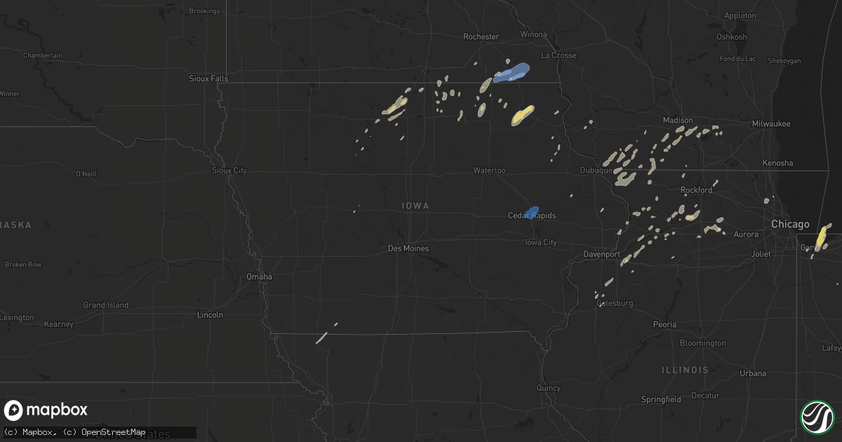
Hail Map in Iowa on September 12, 2019
Get this storm
September 12 map
$229
one time, instant access
Download today. No call, no setup
Keep the $229
Bought the map and want the full workflow? Apply the entire $229 to a subscription within 7 days. None of it is wasted.
Every map, not just this one
This buys you this map. Subscription and you get every map we run, in the markets you choose from a few cities to whole states to nationwide. Plus real-time alerts the moment a storm fires.
Contact data
Name, contact info, occupancy, even credit band for addresses in the footprint. You go from where it hit to who to call.
Become the source they trust
Unlimited branding weather history reports on demand. You already have the documented answer ready for the property owner, and you are the one who showed up with it.
Property data and RoofTrace estimates
Pull up any address you have got, its value and the exact code rules for that jurisdiction, straight from One Click Code. Then RoofTrace estimates the squares, pitch, and roof value, priced the way you price.
Storm reports in Iowa
Iowa
| Date | Description |
|---|---|
| 09/12/20196:04 PM CDT | A local report indicates 60 MPH wind near CLAYTON CENTER |
| 09/12/20195:34 PM CDT | An ef0 tornado touched down initially 5 mile west of farmersburg at 534 pm cdt and dissipated 2 miles southwest of monona at 541 pm cdt. Path length was 4.3 miles. Path |
| 09/12/20195:22 PM CDT | Trees and branches down near east main and d5x. |
| 09/12/20195:09 PM CDT | Trained spotter reported tops of trees blown down on roadway seven miles east of colwell. |
| 09/12/20194:55 PM CDT | Just spotted along hwy w14. |
| 09/12/20194:54 PM CDT | Possible tornado damage about 2.5 miles south southeast of ossian. |
| 09/12/20194:50 PM CDT | Report from mping: tree limbs broken. |
| 09/12/20194:45 PM CDT | Several tree limbs down in the road. Time estimate front radar. |
| 09/12/20194:40 PM CDT | Large tree limb down in driveway on clifton st ne... Relayed by broadcast media. |
| 09/12/20191:19 AM CDT | At 618 PM CDT, a severe thunderstorm was located near Lisbon, or 8 miles southwest of Mechanicsville, moving northeast at 50 mph. HAZARD...60 mph wind gusts and penny size hail. SOURCE...Radar indicated. IMPACT...Expect damage to roofs, siding, and trees. Locations impacted include... Anamosa, Mechanicsville, Stanwood, Mount Vernon, Monticello, Lisbon, Solon, Olin, Wyoming, Martelle, Onslow, Morley, Center Junction, Langworthy, Canton, Sutliff, Monticello Municipal Airport, Jones County Fairgrounds, Cedar Bluff and Pictured Rocks Wildlife Area. |
| 09/12/201912:04 AM CDT | At 503 PM CDT, a severe thunderstorm was located near Ossian, or 13 miles northeast of West Union, moving northeast at 20 mph. HAZARD...70 mph wind gusts and nickel size hail. SOURCE...Radar indicated. IMPACT...Expect considerable tree damage. Damage is likely to mobile homes, roofs, and outbuildings. This severe thunderstorm will be near... Postville around 515 PM CDT. Waukon around 545 PM CDT.Other locations impacted by this severe thunderstorm include CountyRoads X 16 And B 38, State Road 76 And County X 16, Frankville, StateRoad 51 And County W 48, Ludlow, Hardin and Castalia.This storm is also producing frequent dangerous lightning. |
| 09/11/201911:50 PM CDT | At 450 PM CDT, a severe thunderstorm was located over Alburnett, or 13 miles north of Cedar Rapids, moving north at 50 mph. HAZARD...60 mph wind gusts. SOURCE...Radar indicated. IMPACT...Expect damage to roofs, siding, and trees. Locations impacted include... Cedar Rapids, Manchester, Marion, Hiawatha, Robins, Central City, Springville, Edgewood, Earlville, Alburnett, Coggon, Lamont, Delhi, Colesburg, Ryan, Greeley, Prairieburg, Dundee, Delaware and Masonville.This includes Interstate 380 between mile markers 25 and 32. |
| 09/11/201911:11 PM CDT | At 411 PM CDT, a severe thunderstorm was located near Harmony, or near Preston, moving east at 40 mph. HAZARD...70 mph wind gusts. SOURCE...Trained weather spotters. A wind gust to 72 mph was recorded 4 miles south of Greenleafton around 410 PM. IMPACT...Expect considerable tree damage. Damage is likely to mobile homes, roofs, and outbuildings. This severe thunderstorm will be near... Harmony around 415 PM CDT. Canton around 420 PM CDT. Mabel around 435 PM CDT.Other locations impacted by this severe thunderstorm includeHenrytown, Forestville State Park, Choice, Carimona, York, Hutton andGreenleafton. |
| 09/11/20198:58 PM CDT | At 158 PM CDT, a severe thunderstorm was located near Glenville, or near Northwood, moving northeast at 40 mph. HAZARD...60 mph wind gusts and quarter size hail. SOURCE...Radar indicated. IMPACT...Hail damage to vehicles is expected. Expect wind damage to roofs, siding, and trees. Locations impacted include... Glenville, London, Hayward and Myrtle. This includes the following highways... Interstate 35 between mile markers 1 and 4. Interstate 90 between mile markers 163 and 173. |
| 09/11/20198:08 PM CDT | At 107 PM CDT, a severe thunderstorm was located 7 miles northwest of Eagle Lake, or 9 miles west of Forest City, moving northeast at 30 mph. HAZARD...Quarter size hail. SOURCE...Radar indicated. IMPACT...Damage to vehicles is expected. Locations impacted include... Forest City, Thompson, Leland, Crystal Lake, Woden, Hayfield, Pilot Knob State Park and Forest City Municipal Airport. |
All States Impacted by Hail Map on September 12, 2019
Cities Impacted by Hail Map on September 12, 2019
- Cheraw, SC
- Monticello, WI
- Belleville, WI
- Albany, WI
- Warsaw, IN
- Jefferson, WI
- Edgewood, IA
- Tonkawa, OK
- Happy, TX
- North Manchester, IN
- Elma, IA
- Ionia, IA
- Alta Vista, IA
- New Hampton, IA
- Charles City, IA
- Mutual, OK
- Vici, OK
- Seiling, OK
- Chester, OK
- Quitaque, TX
- Argyle, WI
- Geneseo, IL
- Medford, OK
- Americus, KS
- Emporia, KS
- Marion, IN
- Van Buren, IN
- Darlington, WI
- Shullsburg, WI
- Cuba City, WI
- Palatine, IL
- Arlington Heights, IL
- Buffalo Grove, IL
- Lake Zurich, IL
- Dixon, IL
- Oregon, IL
- Garber, OK
- Fairmont, OK
- Leedey, OK
- Billings, OK
- Tulia, TX
- Braman, OK
- Tatum, NM
- Mcdonald, NM
- Lovington, NM
- Logansport, IN
- Goltry, OK
- Enid, OK
- Lahoma, OK
- Carrier, OK
- Marathon, TX
- Wayside, TX
- Claude, TX
- Barneveld, WI
- South Wayne, WI
- Gratiot, WI
- Harmon, IL
- Saint Paul, KS
- Ossian, IA
- Calmar, IA
- Decorah, IA
- Postville, IA
- Waucoma, IA
- West Union, IA
- Fort Atkinson, IA
- Saint Lucas, IA
- Springbrook, WI
- Denver, IN
- Peru, IN
- Livermore, IA
- Chesterton, IN
- Portage, IN
- Hepler, KS
- Girard, KS
- Walnut, KS
- Jones, OK
- Harrah, OK
- Choctaw, OK
- Spencer, OK
- Cassatt, SC
- Monroe, WI
- Chadwick, IL
- Lanark, IL
- Valparaiso, IN
- Crystal Lake, IA
- Leland, IA
- Britt, IA
- Woden, IA
- Thompson, IA
- Forest City, IA
- Wesley, IA
- Arnett, OK
- Georgetown, DE
- Millsboro, DE
- Hawkeye, IA
- Castalia, IA
- Clarendon, TX
- Winona Lake, IN
- North Webster, IN
- Leesburg, IN
- Millersburg, IN
- Goshen, IN
- Sterling, IL
- Farlington, KS
- Fort Scott, KS
- Uniontown, KS
- Rose Hill, KS
- Stony Creek, VA
- Mason City, IA
- Osco, IL
- Redkey, IN
- Preston, MN
- Lanesboro, MN
- Fountain, MN
- North Liberty, IN
- Poplar Grove, IL
- Capron, IL
- Milledgeville, IL
- Canyon, TX
- Dimmitt, TX
- Lena, IL
- Mount Hope, WI
- Woodman, WI
- Ashton, IL
- Chana, IL
- Lindenwood, IL
- Rochelle, IL
- Blanchard, OK
- Newcastle, OK
- New Glarus, WI
- Elsmore, KS
- Moran, KS
- Norfolk, VA
- Waterman, IL
- Dekalb, IL
- Stoughton, WI
- Cambridge, WI
- Fulton, IL
- Clinton, IA
- Yorktown, TX
- Garner, IA
- Elkader, IA
- Pawnee, OK
- Mocksville, NC
- Osage, IA
- Buchanan, MI
- Algona, IA
- Floyd, IA
- Rockford, IA
- Kress, TX
- Fairfax, MO
- Burlington Junction, MO
- Grand Meadow, MN
- Parsons, KS
- Waukomis, OK
- Roanoke, IN
- Coyle, OK
- Cherokee, OK
- Milford, IN
- Craig, MO
- Fort Atkinson, WI
- Whitewater, WI
- Riceville, IA
- Muleshoe, TX
- Nappanee, IN
- Etna Green, IN
- Oregon, WI
- Mcfarland, WI
- Madison, WI
- Corwith, IA
- Belmond, IA
- Jefferson, IA
- Fredonia, KS
- Benedict, KS
- Cambridge, IL
- Ponca City, OK
- Protivin, IA
- Cresco, IA
- Ridgeway, IA
- Twelve Mile, IN
- Rochester, IN
- Boscobel, WI
- Taloga, OK
- Browntown, WI
- Winslow, IL
- Alexis, IL
- Gerlaw, IL
- Apple River, IL
- Stockton, IL
- Galena, IL
- Hanover, IL
- Warren, IL
- Scales Mound, IL
- Elizabeth, IL
- Monmouth, IL
- Charles City, VA
- Camanche, IA
- Cordova, IL
- Red Rock, OK
- Marland, OK
- Hobart, IN
- Merrillville, IN
- Crown Point, IN
- Lake Station, IN
- Gary, IN
- Edgerton, WI
- Alpha, IL
- New Windsor, IL
- Trego, WI
- Pond Creek, OK
- Lime Springs, IA
- Beloit, WI
- Fall River, KS
- Ridgeville, IN
- Portland, IN
- Dunkirk, IN
- Milnesand, NM
- Crossroads, NM
- Severy, KS
- Kremlin, OK
- Lamont, OK
- Hunter, OK
- New Kent, VA
- Quinton, VA
- Leon, KS
- Douglass, KS
- Belmont, WI
- Woosung, IL
- Polo, IL
- Rock Falls, IL
- Little York, IL
- Greeley, IA
- Chesapeake, VA
- Virginia Beach, VA
- Northwood, IA
- Lake Mills, IA
- Bedford, IA
- Clearmont, MO
- Compton, IL
- Steward, IL
- Jefferson, SC
- Mount Croghan, SC
- Fairfax, OK
- Ralston, OK
- Sharon, OK
- Byron, IL
- Ottosen, IA
- Bradgate, IA
- Mineral Point, WI
- Atlanta, KS
- Providence Forge, VA
- Dinwiddie, VA
- Carson, VA
- Holton, KS
- Perry, OK
- Harmony, MN
- Lyle, MN
- Austin, MN
- Cascade, IA
- Monticello, IA
- Oakwood, OK
- Cheyenne, OK
- Tampico, IL
- Prophetstown, IL
- South Haven, KS
- Brooklyn, WI
- Meridian, OK
- Guthrie, OK
- Bourbon, IN
- Garber, IA
- Guttenberg, IA
- Niles, MI
- Davis Junction, IL
- Helena, OK
- Wallace, SC
- Buffalo, KS
- Delmar, IA
- Maquoketa, IA
- Winnebago, IL
- La Fontaine, IN
- Harpers Ferry, IA
- Morrison, IL
- Lyndon, IL
- Erie, IL
- Walkerton, IN
- Chester, IA
- Le Roy, MN
- Spring Valley, MN
- Kensett, IA
- Jarratt, VA
- Enfield, NC
- Littleton, NC
- Halifax, NC
- New Paris, IN
- Mount Morris, IL
- Shannon, IL
- Saint Ansgar, IA
- Grafton, IA
- Deerfield, IL
- Lincolnshire, IL
- Osage City, KS
- Patrick, SC
- Gilmore City, IA
- Chesterfield, SC
- Manly, IA
- Plymouth, IA
- Hinckley, IL
- Hedley, TX
- Mount Carroll, IL
- Durand, IL
- Emporia, VA
- Yale, VA
- Humboldt, IA
- Glenville, MN
- Fairview, OK
- Maple Park, IL
- Cortland, IL
- Sycamore, IL
- Princeton, IL
- Ohio, IL
- Malta, IL
- Lee, IL
- Shabbona, IL
- Bode, IA
- San Pierre, IN
- Mulhall, OK
- Bartlett, KS
- Edna, KS
- Farwell, TX
- Hazel Green, WI
- Platteville, WI
- Thomson, IL
- Savanna, IL
- Drummond, OK
- Maramec, OK
- Cleveland, OK
- Mabel, MN
- Rushford, MN
- Peterson, MN
- Canton, MN
- Spring Grove, MN
- Houston, MN
- Robins, IA
- Palo, IA
- Hiawatha, IA
- Cedar Rapids, IA
- Marion, IA
- Dagsboro, DE
- Frankford, DE
- Weatherford, OK
- Corn, OK


