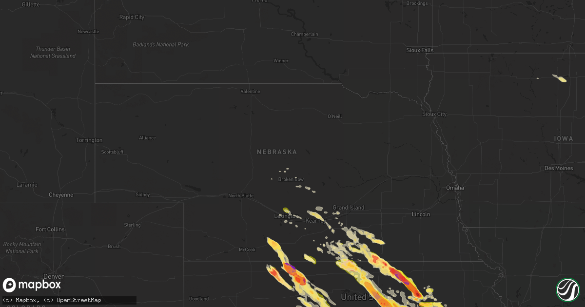
Hail Map in Nebraska on September 10, 2015
Get this storm
September 10 map
$229
one time, instant access
Download today. No call, no setup
Keep the $229
Bought the map and want the full workflow? Apply the entire $229 to a subscription within 7 days. None of it is wasted.
Every map, not just this one
This buys you this map. Subscription and you get every map we run, in the markets you choose from a few cities to whole states to nationwide. Plus real-time alerts the moment a storm fires.
Contact data
Name, contact info, occupancy, even credit band for addresses in the footprint. You go from where it hit to who to call.
Become the source they trust
Unlimited branding weather history reports on demand. You already have the documented answer ready for the property owner, and you are the one who showed up with it.
Property data and RoofTrace estimates
Pull up any address you have got, its value and the exact code rules for that jurisdiction, straight from One Click Code. Then RoofTrace estimates the squares, pitch, and roof value, priced the way you price.
Storm reports in Nebraska
Nebraska
| Date | Description |
|---|---|
| 09/10/20156:58 PM CDT | Hail from marble to quarter size with 70 mph winds. |
| 09/10/20156:52 PM CDT | Time est fm radar. Photo received via social media of 2.5 to 3 inch diameter hailstones. |
| 09/10/20156:06 PM CDT | Half dollar size hail reported near the patterson harbor on the south side of harlan lake. |
| 09/10/20156:05 PM CDT | A local report indicates 60 MPH wind near 4 NNE RED CLOUD |
| 09/10/20156:03 PM CDT | A local report indicates 69 MPH wind near 9 NW RED CLOUD |
| 09/10/20156:00 PM CDT | Golf ball size hail in chester broke the back window of a car. |
| 09/10/20155:58 PM CDT | Quarter size hail with some bigger stones between 530 and 6 pm. Delayed report from last night. |
| 09/10/20155:52 PM CDT | Dime to golf ball size hail now falling in chester. |
| 09/10/20155:51 PM CDT | Dime to half dollar size hail falling right now. |
| 09/10/20155:51 PM CDT | Public report of half dollar size hail in chester. Relayed by nws omaha office. |
| 09/10/20155:47 PM CDT | A local report indicates 1.00 inch wind near CHESTER |
| 09/10/20155:33 PM CDT | A few up to ping pong ball size |
| 09/10/20155:27 PM CDT | Time est fm radar. |
| 09/10/20155:27 PM CDT | A local report indicates 2.50 inch wind near 2 SW HOLBROOK |
| 09/10/20155:25 PM CDT | Hail up to quarter size. |
| 09/10/20155:08 PM CDT | Hailed from approx. 508-518 pm...largest ping pong ball |
| 09/10/20154:44 PM CDT | Nickel to some quarter size. Time est fm radar. |
| 09/10/20154:44 PM CDT | Nickel to some quarter size. Time est fm radar. Corrected location. |
| 09/10/20154:30 PM CDT | Trained spotter reported hail from pea to quarter size. |
| 09/10/20154:25 PM CDT | Hail up to half dollar size and heavy rain. |
All States Impacted by Hail Map on September 10, 2015
Cities Impacted by Hail Map on September 10, 2015
- Smithshire, IL
- Kirkwood, IL
- Biggsville, IL
- Miltonvale, KS
- Delphos, KS
- Aurora, KS
- Hoisington, KS
- Ellinwood, KS
- St John, KS
- Sylvia, KS
- Raymond, KS
- Olmitz, KS
- Great Bend, KS
- Hudson, KS
- Lenora, KS
- Randolph, KS
- Leonardville, KS
- Yates Center, KS
- Bloomfield, IA
- Moulton, IA
- Manter, KS
- Richfield, KS
- Johnson, KS
- Minden, NE
- Linn, KS
- Chapman, KS
- Wakefield, KS
- Princeton, KS
- Ottawa, KS
- Pomona, KS
- Williamsburg, KS
- Fairfield, NE
- Deweese, NE
- Ulysses, KS
- Belleville, KS
- Narka, KS
- Munden, KS
- Overbrook, KS
- Baldwin City, KS
- Waucoma, IA
- Lawler, IA
- Fredericksburg, IA
- Le Roy, KS
- Burlington, KS
- Republican City, NE
- Naponee, NE
- Ransom, KS
- Ness City, KS
- Utica, KS
- Arnold, KS
- Russell, KS
- Sheffield, IL
- Mineral, IL
- Annawan, IL
- Alton, KS
- Minneapolis, KS
- Glasco, KS
- Clay Center, KS
- Butler, MO
- Amoret, MO
- Amsterdam, MO
- Manhattan, KS
- Saint George, KS
- Arapahoe, NE
- Cambridge, NE
- Holbrook, NE
- Greenville, IL
- Mulberry Grove, IL
- Smithboro, IL
- Upland, NE
- Astoria, IL
- Hays, KS
- Arkansas City, KS
- Burr Oak, KS
- Esbon, KS
- Hebron, NE
- Deshler, NE
- Chester, NE
- Norcatur, KS
- Norton, KS
- Bogue, KS
- Belvue, KS
- Wamego, KS
- Paxico, KS
- Gridley, KS
- Madison, KS
- Hartford, KS
- Hamilton, KS
- Olpe, KS
- Hartley, TX
- Beaver City, NE
- Hendley, NE
- Auburn, KS
- Henderson, NC
- Oxford, NC
- Unionville, IA
- Jetmore, KS
- Bushton, KS
- Luray, KS
- Almena, KS
- Prairie View, KS
- Stockton, KS
- Kirwin, KS
- Phillipsburg, KS
- Glade, KS
- Woodston, KS
- Natoma, KS
- Lucas, KS
- Long Island, KS
- Osborne, KS
- Edison, NE
- Logan, KS
- Paradise, KS
- Eustis, NE
- Waldo, KS
- Shickley, NE
- Davenport, NE
- Carleton, NE
- Bruning, NE
- Concordia, KS
- Jamestown, KS
- Jewell, KS
- Norway, KS
- Media, IL
- Monmouth, IL
- Burlington, IA
- Roseville, IL
- Oquawka, IL
- Alma, KS
- Westmoreland, KS
- Nelson, NE
- Oak, NE
- Goodwell, OK
- New Berlin, IL
- Bath, IL
- Tallula, IL
- Browning, IL
- Petersburg, IL
- Havana, IL
- Chandlerville, IL
- Oakford, IL
- Ipava, IL
- Pleasant Plains, IL
- Springfield, IL
- Kilbourne, IL
- Haddam, KS
- Morrowville, KS
- Washington, KS
- Byron, NE
- Cuba, KS
- Republic, KS
- Clifton, KS
- Greenleaf, KS
- Palmer, KS
- Hubbell, NE
- Hardy, NE
- Winfield, KS
- Ashford, AL
- Cowarts, AL
- Dothan, AL
- Webb, AL
- Canton, IL
- Quenemo, KS
- Downing, MO
- Drakesville, IA
- Lancaster, MO
- Humansville, MO
- Stockton, MO
- Minneola, KS
- Ford, KS
- Bucklin, KS
- Bladen, NE
- Hollister, MO
- Dalhart, TX
- Spearville, KS
- Lebanon, KS
- Flemington, MO
- Colony, KS
- Covington, GA
- Osawatomie, KS
- Lane, KS
- Parker, KS
- California, MO
- Perry, OK
- Stillwater, OK
- Wilson, KS
- Claflin, KS
- Ellis, KS
- Dorrance, KS
- Holyrood, KS
- Catharine, KS
- Plainville, KS
- Bunker Hill, KS
- Gorham, KS
- Walker, KS
- Victoria, KS
- Sunray, TX
- Lakin, KS
- Deerfield, KS
- Holcomb, KS
- Haviland, KS
- Agenda, KS
- Olsburg, KS
- Lawrence, NE
- Guide Rock, NE
- Barnes, KS
- Riley, KS
- Ruskin, NE
- Superior, NE
- Green, KS
- Edgar, NE
- Blue Hill, NE
- Lampe, MO
- Berryville, AR
- Fort Riley, KS
- Bloomington, NE
- Aurora, MO
- Kinston, NC
- La Grange, NC
- Haven, KS
- Council Grove, KS
- Allen, KS
- Americus, KS
- Abilene, KS
- Longford, KS
- Eskridge, KS
- Randall, KS
- Hutchinson, KS
- Pretty Prairie, KS
- Abbyville, KS
- Garden Plain, KS
- Partridge, KS
- Andale, KS
- Goddard, KS
- Cheney, KS
- Mount Hope, KS
- Walker, MO
- Little River, AL
- Sarcoxie, MO
- Pierce City, MO
- Harveyville, KS
- Reading, KS
- Mason City, NE
- Union Mills, NC
- Rutherfordton, NC
- Green Forest, AR
- Blue Eye, MO
- Shell Knob, MO
- Oak Grove, AR
- Perkins, OK
- Anselmo, NE
- Carthage, MO
- Bertrand, NE
- Smithfield, NE
- Greenfield, MO
- Dadeville, MO
- Mullinville, KS
- Hanston, KS
- Beeler, KS
- Offerle, KS
- Greensburg, KS
- Cimarron, KS
- Dighton, KS
- Newkirk, OK
- Kaw City, OK
- Theodosia, MO
- Liberal, KS
- Hugoton, KS
- Moscow, KS
- Luray, MO
- Arbela, MO
- Kearney, NE
- Riverdale, NE
- Rolla, KS
- Borger, TX
- Skellytown, TX
- El Dorado Springs, MO
- Mankato, KS
- Humboldt, KS
- New Hampton, IA
- Ionia, IA
- Juniata, NE
- Campbell, NE
- Douglass, KS
- Augusta, KS
- Eddyville, NE
- Lexington, NE
- Red Cloud, NE
- Guymon, OK
- Hastings, NE
- Clay Center, NE
- Saronville, NE
- Geneva, NE
- Ong, NE
- Inland, NE
- Sutton, NE
- Harvard, NE
- Pocahontas, IL
- Carlyle, IL
- Breese, IL
- Charles City, IA
- Floyd, IA
- Chase, KS
- Callaway, NE
- Scranton, KS
- Carbondale, KS
- Doniphan, MO
- Olathe, KS
- Gardner, KS
- Iola, KS
- Paola, KS
- Glenvil, NE
- Ayr, NE
- Maxton, NC
- Red Springs, NC
- Inavale, NE
- Beloit, KS
- Formoso, KS
- Junction City, KS
- Riverton, NE
- Webber, KS
- Gibbon, NE
- Bamberg, SC
- Wellsville, KS
- Lawrence, KS
- Carrier, OK
- Goltry, OK
- Lahoma, OK
- Jet, OK
- Sorento, IL
- Walshville, IL
- Neosho Falls, KS
- Herscher, IL
- Maple Hill, KS
- Del Valle, TX
- Hardesty, OK
- Round O, SC
- Heartwell, NE
- Shelton, NE
- Keosauqua, IA
- Mount Sterling, IA
- Cantril, IA
- Wyaconda, MO
- Morganville, KS
- Wood River, NE
- Holstein, NE
- Kenesaw, NE
- Beckemeyer, IL
- Highland, IL
- Amherst, NE
- Stinnett, TX
- Gruver, TX
- Spearman, TX
- Morse, TX
- Garner, IA
- Linwood, NC
- Hillsboro, IL
- Garnett, KS
- Melvern, KS
- Waverly, KS
- Richmond, KS
- Edisto Island, SC
- Montrose, MO
- Appleton City, MO
- Floris, IA
- Milton, IA
- Selma, IA
- Eldon, IA
- Douds, IA
- Litchfield, IL
- Panama, IL
- De Soto, KS
- Bullock, NC
- Table Grove, IL
- Enid, OK
- Meno, OK
- Mulhall, OK
- Dunnegan, MO
- Knox City, MO
- Thornton, IA
- Ventura, IA
- Alma, NE
- Agra, KS
- Red Rock, OK
- Osage City, KS
- Lebo, KS
- Archie, MO
- Harrisonville, MO
- Hooker, OK
- Norwood, GA
- Greenfield, IL
- Rockbridge, IL
- Medora, IL
- Calhoun, MO
- Clinton, MO
- Topeka, KS
- Berryton, KS
- Brinson, GA
- Iron City, GA
- Blue Rapids, KS
- Raymond, IL
- Holdrege, NE
- Cozad, NE
- Barnhart, MO
- Pevely, MO
- Courtland, KS
- Milford, KS
- Marion, NC
- Windsor, NC
- Merry Hill, NC
- Unionville, MO
- Exline, IA
- Livonia, MO
- Girard, GA
- Elwood, NE
- Tecumseh, KS
- Sumner, IA
- Wakarusa, KS
- Kensington, KS
- Colwell, IA
- Waynesboro, GA
- Bonner Springs, KS
- New Century, KS
- Edgerton, KS
- Shawnee, KS
- Spring Hill, KS
- Kansas City, KS
- Eudora, KS
- Lenexa, KS
- Granville, IL
- Peru, IL
- Clear Lake, IA
- Klemme, IA
- Ashland, IL
- Strong City, KS
- Emporia, KS
- New Liberty, IA
- Ozark, MO
- Black, AL
- La Belle, MO
- Pleasanton, KS
- Bucyrus, KS
- Louisburg, KS
- Exeter, MO
- Cherokee, OK
- Nash, OK
- Vassar, KS
- Burlingame, KS
- Admire, KS
- Neosho Rapids, KS
- Rantoul, KS
- Lyndon, KS
- Columbia, AL
- Headland, AL
- Cottonwood, AL
- Pansey, AL
- Everton, MO
- Bazine, KS
- Elkhart, KS
- Wentworth, MO
- La Russell, MO
- Stotts City, MO
- Yemassee, SC
- Clopton, AL
- Eufaula, AL
- Abbeville, AL
- Clayton, AL
- Garden City, MO
- Stockton, AL
- Leoti, KS
- Bartelso, IL
- New Douglas, IL
- Okawville, IL
- Nashville, IL
- Toronto, KS
- Fall River, KS
- Hildreth, NE
- Cassville, MO
- Eagle Rock, MO
- Golden, MO
- Chanute, KS
- Piqua, KS
- El Dorado, KS
- Grantville, KS
- Perry, KS
- Osceola, MO
- Collins, MO
- Mansfield, GA
- Rutledge, GA
- Savannah, GA
- Rueter, MO
- Manito, IL
- Otis, KS
- Woodbine, KS
- White City, KS
- Realitos, TX
- Wheatland, MO
- Pfeifer, KS
- Albert, KS
- Palco, KS
- Bison, KS
- Tennille, GA
- Wesley, IA
- Clyde, KS
- Fillmore, IL
- Worden, IL
- Bunker Hill, IL
- Spring Hope, NC
- Gable, SC
- New Zion, SC
- Alcolu, SC
- Loomis, NE
- Urich, MO
- Conchas Dam, NM
- Belle Plaine, KS
- Udall, KS
- Sheldon, MO
- Hillsboro, MO
- Lowry City, MO
- Thomson, GA
- Billings, OK
- Garber, OK
- Covington, OK
- Scandia, KS
- Enterprise, KS
- Alta Vista, KS
- Talmage, KS
- Solomon, KS
- Rossville, KS
- McFarland, KS
- Saint Marys, KS
- Glasford, IL
- Kincaid, KS
- Ansley, NE
- Kremlin, OK
- Dixon, IA
- Bennett, IA
- Donahue, IA
- Merna, NE
- Miller, MO
- South Greenfield, MO
- Lockwood, MO
- Hertford, NC
- Atlanta, GA
- Hermitage, MO
- Preston, MO
- Nixa, MO
- Burnet, TX
- Overton, NE
- Elm Creek, NE
- Arnold, MO
- Imperial, MO
- Herculaneum, MO
- Festus, MO
- Bainbridge, GA
- Donalsonville, GA
- Clifton, IL
- Eureka, KS
- Severy, KS
- Piedmont, KS
- Ellisville, IL
- Smithfield, IL
- La Cygne, KS
- Andover, KS
- Fair Play, MO
- Leon, KS
- Ottumwa, IA
- Cameron, SC
- Beaver, OK
- Seligman, MO
- Britt, IA
- Ravenna, NE
- Pleasanton, NE
- Avon, IL
- Mount Vernon, MO
- Hillsboro, GA
- Waynesboro, MS
- La Harpe, KS
- Edenton, NC
- Greeley, KS
- Reeds, MO
- Avilla, MO
- Lecompton, KS
- Franklin, NE
- Diamond, MO
- Franklin, IL
- Frankfort, KS
- Rockville, MO
- Schell City, MO
- Quinter, KS
- Coffeen, IL
- Theriot, LA
- Kansas City, MO
- Fenton, MO
- Austin, TX
- Sterling, KS
- Deepwater, MO
- Peel, AR
- Stark City, MO
- Fairview, MO
- Purdy, MO
- Virgil, KS
- Neal, KS
- Oakville, IA
- Mediapolis, IA
- Grandy, NC
- Warrenton, GA
- Camak, GA
- Wapello, IA
- Dodge City, KS
- Leary, GA
- Walnut Grove, MO
- Nevada, MO
- Verona, MO
- Monroe City, MO
- Marietta, IL
- Cuba, IL
- Saint Pauls, NC
- Nashua, IA
- Litchfield, NE
- Rush Center, KS
- Tyner, NC
- Monett, MO
- Wilcox, NE
- Milo, MO
- Jacksonville, IL
- Alexander, IL
- Jasper, MO
- Neck City, MO
- Chatham, IL
- Westphalia, KS
- Lyons, KS
- Vermont, IL
- Hollywood, SC
- Cleveland, MO
- Belton, MO
- Weaubleau, MO
- Golden City, MO
- Cedarcreek, MO
- Lead Hill, AR
- Hume, MO
- Lorraine, KS
- Moravia, IA
- Udell, IA
- Syracuse, KS


