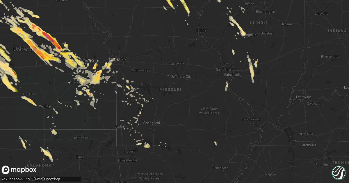
Hail Map in Missouri on September 10, 2015
Get this storm
September 10 map
$229
one time, instant access
Download today. No call, no setup
Keep the $229
Bought the map and want the full workflow? Apply the entire $229 to a subscription within 7 days. None of it is wasted.
Every map, not just this one
This buys you this map. Subscription and you get every map we run, in the markets you choose from a few cities to whole states to nationwide. Plus real-time alerts the moment a storm fires.
Contact data
Name, contact info, occupancy, even credit band for addresses in the footprint. You go from where it hit to who to call.
Become the source they trust
Unlimited branding weather history reports on demand. You already have the documented answer ready for the property owner, and you are the one who showed up with it.
Property data and RoofTrace estimates
Pull up any address you have got, its value and the exact code rules for that jurisdiction, straight from One Click Code. Then RoofTrace estimates the squares, pitch, and roof value, priced the way you price.
Storm reports in Missouri
Missouri
| Date | Description |
|---|---|
| 09/10/20154:20 PM CDT | Crop damage due to large hail. |
| 09/10/20152:55 PM CDT | A couple of downed trees on front street near highway z. One tree was 2.5 feet in diameter and fell ontu power lines. Time estimated from radar. |
| 09/09/20159:26 PM CDT | A local report indicates 60 MPH wind near 4 NNW GLADSTONE |
| 09/09/20159:24 PM CDT | Several reports from kc fire of tree limbs and power lines down...south and east of the downtown kc area |
| 09/09/20159:20 PM CDT | Estimated 60-65 mph winds at mile marker 6 on interstate 70w. |
| 09/09/20159:11 PM CDT | Tree limb fell onto power lines south of downtown kansas city |
| 09/09/20159:06 PM CDT | A local report indicates 1.25 inch wind near 4 NE GRANGER |
| 09/09/20159:06 PM CDT | Tree limb snapped and fell onto power line |
| 09/09/20158:56 PM CDT | Reported hail was mostly nickel or smaller but a few stones were the size of quarters. |
All States Impacted by Hail Map on September 10, 2015
Cities Impacted by Hail Map on September 10, 2015
- Smithshire, IL
- Kirkwood, IL
- Biggsville, IL
- Miltonvale, KS
- Delphos, KS
- Aurora, KS
- Hoisington, KS
- Ellinwood, KS
- St John, KS
- Sylvia, KS
- Raymond, KS
- Olmitz, KS
- Great Bend, KS
- Hudson, KS
- Lenora, KS
- Randolph, KS
- Leonardville, KS
- Yates Center, KS
- Bloomfield, IA
- Moulton, IA
- Manter, KS
- Richfield, KS
- Johnson, KS
- Minden, NE
- Linn, KS
- Chapman, KS
- Wakefield, KS
- Princeton, KS
- Ottawa, KS
- Pomona, KS
- Williamsburg, KS
- Fairfield, NE
- Deweese, NE
- Ulysses, KS
- Belleville, KS
- Narka, KS
- Munden, KS
- Overbrook, KS
- Baldwin City, KS
- Waucoma, IA
- Lawler, IA
- Fredericksburg, IA
- Le Roy, KS
- Burlington, KS
- Republican City, NE
- Naponee, NE
- Ransom, KS
- Ness City, KS
- Utica, KS
- Arnold, KS
- Russell, KS
- Sheffield, IL
- Mineral, IL
- Annawan, IL
- Alton, KS
- Minneapolis, KS
- Glasco, KS
- Clay Center, KS
- Butler, MO
- Amoret, MO
- Amsterdam, MO
- Manhattan, KS
- Saint George, KS
- Arapahoe, NE
- Cambridge, NE
- Holbrook, NE
- Greenville, IL
- Mulberry Grove, IL
- Smithboro, IL
- Upland, NE
- Astoria, IL
- Hays, KS
- Arkansas City, KS
- Burr Oak, KS
- Esbon, KS
- Hebron, NE
- Deshler, NE
- Chester, NE
- Norcatur, KS
- Norton, KS
- Bogue, KS
- Belvue, KS
- Wamego, KS
- Paxico, KS
- Gridley, KS
- Madison, KS
- Hartford, KS
- Hamilton, KS
- Olpe, KS
- Hartley, TX
- Beaver City, NE
- Hendley, NE
- Auburn, KS
- Henderson, NC
- Oxford, NC
- Unionville, IA
- Jetmore, KS
- Bushton, KS
- Luray, KS
- Almena, KS
- Prairie View, KS
- Stockton, KS
- Kirwin, KS
- Phillipsburg, KS
- Glade, KS
- Woodston, KS
- Natoma, KS
- Lucas, KS
- Long Island, KS
- Osborne, KS
- Edison, NE
- Logan, KS
- Paradise, KS
- Eustis, NE
- Waldo, KS
- Shickley, NE
- Davenport, NE
- Carleton, NE
- Bruning, NE
- Concordia, KS
- Jamestown, KS
- Jewell, KS
- Norway, KS
- Media, IL
- Monmouth, IL
- Burlington, IA
- Roseville, IL
- Oquawka, IL
- Alma, KS
- Westmoreland, KS
- Nelson, NE
- Oak, NE
- Goodwell, OK
- New Berlin, IL
- Bath, IL
- Tallula, IL
- Browning, IL
- Petersburg, IL
- Havana, IL
- Chandlerville, IL
- Oakford, IL
- Ipava, IL
- Pleasant Plains, IL
- Springfield, IL
- Kilbourne, IL
- Haddam, KS
- Morrowville, KS
- Washington, KS
- Byron, NE
- Cuba, KS
- Republic, KS
- Clifton, KS
- Greenleaf, KS
- Palmer, KS
- Hubbell, NE
- Hardy, NE
- Winfield, KS
- Ashford, AL
- Cowarts, AL
- Dothan, AL
- Webb, AL
- Canton, IL
- Quenemo, KS
- Downing, MO
- Drakesville, IA
- Lancaster, MO
- Humansville, MO
- Stockton, MO
- Minneola, KS
- Ford, KS
- Bucklin, KS
- Bladen, NE
- Hollister, MO
- Dalhart, TX
- Spearville, KS
- Lebanon, KS
- Flemington, MO
- Colony, KS
- Covington, GA
- Osawatomie, KS
- Lane, KS
- Parker, KS
- California, MO
- Perry, OK
- Stillwater, OK
- Wilson, KS
- Claflin, KS
- Ellis, KS
- Dorrance, KS
- Holyrood, KS
- Catharine, KS
- Plainville, KS
- Bunker Hill, KS
- Gorham, KS
- Walker, KS
- Victoria, KS
- Sunray, TX
- Lakin, KS
- Deerfield, KS
- Holcomb, KS
- Haviland, KS
- Agenda, KS
- Olsburg, KS
- Lawrence, NE
- Guide Rock, NE
- Barnes, KS
- Riley, KS
- Ruskin, NE
- Superior, NE
- Green, KS
- Edgar, NE
- Blue Hill, NE
- Lampe, MO
- Berryville, AR
- Fort Riley, KS
- Bloomington, NE
- Aurora, MO
- Kinston, NC
- La Grange, NC
- Haven, KS
- Council Grove, KS
- Allen, KS
- Americus, KS
- Abilene, KS
- Longford, KS
- Eskridge, KS
- Randall, KS
- Hutchinson, KS
- Pretty Prairie, KS
- Abbyville, KS
- Garden Plain, KS
- Partridge, KS
- Andale, KS
- Goddard, KS
- Cheney, KS
- Mount Hope, KS
- Walker, MO
- Little River, AL
- Sarcoxie, MO
- Pierce City, MO
- Harveyville, KS
- Reading, KS
- Mason City, NE
- Union Mills, NC
- Rutherfordton, NC
- Green Forest, AR
- Blue Eye, MO
- Shell Knob, MO
- Oak Grove, AR
- Perkins, OK
- Anselmo, NE
- Carthage, MO
- Bertrand, NE
- Smithfield, NE
- Greenfield, MO
- Dadeville, MO
- Mullinville, KS
- Hanston, KS
- Beeler, KS
- Offerle, KS
- Greensburg, KS
- Cimarron, KS
- Dighton, KS
- Newkirk, OK
- Kaw City, OK
- Theodosia, MO
- Liberal, KS
- Hugoton, KS
- Moscow, KS
- Luray, MO
- Arbela, MO
- Kearney, NE
- Riverdale, NE
- Rolla, KS
- Borger, TX
- Skellytown, TX
- El Dorado Springs, MO
- Mankato, KS
- Humboldt, KS
- New Hampton, IA
- Ionia, IA
- Juniata, NE
- Campbell, NE
- Douglass, KS
- Augusta, KS
- Eddyville, NE
- Lexington, NE
- Red Cloud, NE
- Guymon, OK
- Hastings, NE
- Clay Center, NE
- Saronville, NE
- Geneva, NE
- Ong, NE
- Inland, NE
- Sutton, NE
- Harvard, NE
- Pocahontas, IL
- Carlyle, IL
- Breese, IL
- Charles City, IA
- Floyd, IA
- Chase, KS
- Callaway, NE
- Scranton, KS
- Carbondale, KS
- Doniphan, MO
- Olathe, KS
- Gardner, KS
- Iola, KS
- Paola, KS
- Glenvil, NE
- Ayr, NE
- Maxton, NC
- Red Springs, NC
- Inavale, NE
- Beloit, KS
- Formoso, KS
- Junction City, KS
- Riverton, NE
- Webber, KS
- Gibbon, NE
- Bamberg, SC
- Wellsville, KS
- Lawrence, KS
- Carrier, OK
- Goltry, OK
- Lahoma, OK
- Jet, OK
- Sorento, IL
- Walshville, IL
- Neosho Falls, KS
- Herscher, IL
- Maple Hill, KS
- Del Valle, TX
- Hardesty, OK
- Round O, SC
- Heartwell, NE
- Shelton, NE
- Keosauqua, IA
- Mount Sterling, IA
- Cantril, IA
- Wyaconda, MO
- Morganville, KS
- Wood River, NE
- Holstein, NE
- Kenesaw, NE
- Beckemeyer, IL
- Highland, IL
- Amherst, NE
- Stinnett, TX
- Gruver, TX
- Spearman, TX
- Morse, TX
- Garner, IA
- Linwood, NC
- Hillsboro, IL
- Garnett, KS
- Melvern, KS
- Waverly, KS
- Richmond, KS
- Edisto Island, SC
- Montrose, MO
- Appleton City, MO
- Floris, IA
- Milton, IA
- Selma, IA
- Eldon, IA
- Douds, IA
- Litchfield, IL
- Panama, IL
- De Soto, KS
- Bullock, NC
- Table Grove, IL
- Enid, OK
- Meno, OK
- Mulhall, OK
- Dunnegan, MO
- Knox City, MO
- Thornton, IA
- Ventura, IA
- Alma, NE
- Agra, KS
- Red Rock, OK
- Osage City, KS
- Lebo, KS
- Archie, MO
- Harrisonville, MO
- Hooker, OK
- Norwood, GA
- Greenfield, IL
- Rockbridge, IL
- Medora, IL
- Calhoun, MO
- Clinton, MO
- Topeka, KS
- Berryton, KS
- Brinson, GA
- Iron City, GA
- Blue Rapids, KS
- Raymond, IL
- Holdrege, NE
- Cozad, NE
- Barnhart, MO
- Pevely, MO
- Courtland, KS
- Milford, KS
- Marion, NC
- Windsor, NC
- Merry Hill, NC
- Unionville, MO
- Exline, IA
- Livonia, MO
- Girard, GA
- Elwood, NE
- Tecumseh, KS
- Sumner, IA
- Wakarusa, KS
- Kensington, KS
- Colwell, IA
- Waynesboro, GA
- Bonner Springs, KS
- New Century, KS
- Edgerton, KS
- Shawnee, KS
- Spring Hill, KS
- Kansas City, KS
- Eudora, KS
- Lenexa, KS
- Granville, IL
- Peru, IL
- Clear Lake, IA
- Klemme, IA
- Ashland, IL
- Strong City, KS
- Emporia, KS
- New Liberty, IA
- Ozark, MO
- Black, AL
- La Belle, MO
- Pleasanton, KS
- Bucyrus, KS
- Louisburg, KS
- Exeter, MO
- Cherokee, OK
- Nash, OK
- Vassar, KS
- Burlingame, KS
- Admire, KS
- Neosho Rapids, KS
- Rantoul, KS
- Lyndon, KS
- Columbia, AL
- Headland, AL
- Cottonwood, AL
- Pansey, AL
- Everton, MO
- Bazine, KS
- Elkhart, KS
- Wentworth, MO
- La Russell, MO
- Stotts City, MO
- Yemassee, SC
- Clopton, AL
- Eufaula, AL
- Abbeville, AL
- Clayton, AL
- Garden City, MO
- Stockton, AL
- Leoti, KS
- Bartelso, IL
- New Douglas, IL
- Okawville, IL
- Nashville, IL
- Toronto, KS
- Fall River, KS
- Hildreth, NE
- Cassville, MO
- Eagle Rock, MO
- Golden, MO
- Chanute, KS
- Piqua, KS
- El Dorado, KS
- Grantville, KS
- Perry, KS
- Osceola, MO
- Collins, MO
- Mansfield, GA
- Rutledge, GA
- Savannah, GA
- Rueter, MO
- Manito, IL
- Otis, KS
- Woodbine, KS
- White City, KS
- Realitos, TX
- Wheatland, MO
- Pfeifer, KS
- Albert, KS
- Palco, KS
- Bison, KS
- Tennille, GA
- Wesley, IA
- Clyde, KS
- Fillmore, IL
- Worden, IL
- Bunker Hill, IL
- Spring Hope, NC
- Gable, SC
- New Zion, SC
- Alcolu, SC
- Loomis, NE
- Urich, MO
- Conchas Dam, NM
- Belle Plaine, KS
- Udall, KS
- Sheldon, MO
- Hillsboro, MO
- Lowry City, MO
- Thomson, GA
- Billings, OK
- Garber, OK
- Covington, OK
- Scandia, KS
- Enterprise, KS
- Alta Vista, KS
- Talmage, KS
- Solomon, KS
- Rossville, KS
- McFarland, KS
- Saint Marys, KS
- Glasford, IL
- Kincaid, KS
- Ansley, NE
- Kremlin, OK
- Dixon, IA
- Bennett, IA
- Donahue, IA
- Merna, NE
- Miller, MO
- South Greenfield, MO
- Lockwood, MO
- Hertford, NC
- Atlanta, GA
- Hermitage, MO
- Preston, MO
- Nixa, MO
- Burnet, TX
- Overton, NE
- Elm Creek, NE
- Arnold, MO
- Imperial, MO
- Herculaneum, MO
- Festus, MO
- Bainbridge, GA
- Donalsonville, GA
- Clifton, IL
- Eureka, KS
- Severy, KS
- Piedmont, KS
- Ellisville, IL
- Smithfield, IL
- La Cygne, KS
- Andover, KS
- Fair Play, MO
- Leon, KS
- Ottumwa, IA
- Cameron, SC
- Beaver, OK
- Seligman, MO
- Britt, IA
- Ravenna, NE
- Pleasanton, NE
- Avon, IL
- Mount Vernon, MO
- Hillsboro, GA
- Waynesboro, MS
- La Harpe, KS
- Edenton, NC
- Greeley, KS
- Reeds, MO
- Avilla, MO
- Lecompton, KS
- Franklin, NE
- Diamond, MO
- Franklin, IL
- Frankfort, KS
- Rockville, MO
- Schell City, MO
- Quinter, KS
- Coffeen, IL
- Theriot, LA
- Kansas City, MO
- Fenton, MO
- Austin, TX
- Sterling, KS
- Deepwater, MO
- Peel, AR
- Stark City, MO
- Fairview, MO
- Purdy, MO
- Virgil, KS
- Neal, KS
- Oakville, IA
- Mediapolis, IA
- Grandy, NC
- Warrenton, GA
- Camak, GA
- Wapello, IA
- Dodge City, KS
- Leary, GA
- Walnut Grove, MO
- Nevada, MO
- Verona, MO
- Monroe City, MO
- Marietta, IL
- Cuba, IL
- Saint Pauls, NC
- Nashua, IA
- Litchfield, NE
- Rush Center, KS
- Tyner, NC
- Monett, MO
- Wilcox, NE
- Milo, MO
- Jacksonville, IL
- Alexander, IL
- Jasper, MO
- Neck City, MO
- Chatham, IL
- Westphalia, KS
- Lyons, KS
- Vermont, IL
- Hollywood, SC
- Cleveland, MO
- Belton, MO
- Weaubleau, MO
- Golden City, MO
- Cedarcreek, MO
- Lead Hill, AR
- Hume, MO
- Lorraine, KS
- Moravia, IA
- Udell, IA
- Syracuse, KS


