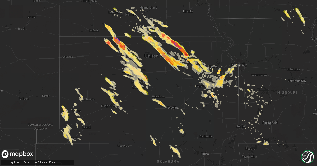
Hail Map in Kansas on September 10, 2015
Get this storm
September 10 map
$229
one time, instant access
Download today. No call, no setup
Keep the $229
Bought the map and want the full workflow? Apply the entire $229 to a subscription within 7 days. None of it is wasted.
Every map, not just this one
This buys you this map. Subscription and you get every map we run, in the markets you choose from a few cities to whole states to nationwide. Plus real-time alerts the moment a storm fires.
Contact data
Name, contact info, occupancy, even credit band for addresses in the footprint. You go from where it hit to who to call.
Become the source they trust
Unlimited branding weather history reports on demand. You already have the documented answer ready for the property owner, and you are the one who showed up with it.
Property data and RoofTrace estimates
Pull up any address you have got, its value and the exact code rules for that jurisdiction, straight from One Click Code. Then RoofTrace estimates the squares, pitch, and roof value, priced the way you price.
Storm reports in Kansas
Kansas
| Date | Description |
|---|---|
| 09/10/20156:56 PM CDT | A local report indicates 68 MPH wind near 3 WNW JEWELL |
| 09/10/20156:55 PM CDT | A local report indicates 60 MPH wind near 3 WSW ULYSSES |
| 09/10/20156:55 PM CDT | A local report indicates 1.00 inch wind near MANKATO |
| 09/10/20156:55 PM CDT | Trees down. Quarter size hail as well. Time est fm radar. |
| 09/10/20156:54 PM CDT | Trained spotter relayed via amatur radio. |
| 09/10/20156:52 PM CDT | Mostly pea to dime size hail but a few were as big as quarters. |
| 09/10/20156:51 PM CDT | Law enforcement reported quarter inch size hail. |
| 09/10/20156:50 PM CDT | A local report indicates 1.00 inch wind near 3 S ARNOLD |
| 09/10/20156:44 PM CDT | Windows broken from hail at homes on the n side of town. Time est fm radar. |
| 09/10/20156:43 PM CDT | Wind measured with davis instrument. Golf ball size hail broke his windshield. |
| 09/10/20156:42 PM CDT | Tree limbs up to five inches in diameter were blown down. |
| 09/10/20156:42 PM CDT | A local report indicates 1.75 inch wind near 10 S NORTON |
| 09/10/20156:40 PM CDT | A local report indicates 1.75 inch wind near 10 SE LINN |
| 09/10/20156:40 PM CDT | A local report indicates 2.75 inch wind near 3 S HADDAM |
| 09/10/20156:40 PM CDT | A local report indicates 74 MPH wind near 3 S HADDAM |
| 09/10/20156:38 PM CDT | A local report indicates 1.00 inch wind near JOHNSON CITY |
| 09/10/20156:35 PM CDT | Tennis ball hail estimated. Wind was not more than 30mph. |
| 09/10/20156:33 PM CDT | Largest hailstones slightly larger than golf balls. Damage to vehicles...including cracked and broken windows/windshields. |
| 09/10/20156:30 PM CDT | A local report indicates 1.75 inch wind near 3 WSW JOHNSON CITY |
| 09/10/20156:25 PM CDT | A few ping pong size stones with 30mph wind. |
| 09/10/20156:25 PM CDT | Golf ball to ping-pong ball size hail 5 minutes later. |
| 09/10/20156:22 PM CDT | A local report indicates 1.25 inch wind near N MANHATTAN |
| 09/10/20156:21 PM CDT | Dime to ping pong size hail. Hardly any wind/rain. |
| 09/10/20156:21 PM CDT | At least one baseball size stone with 60-70mph estimated winds. |
| 09/10/20156:21 PM CDT | Estimated wind gusts of 60-70mph with at least one baseball size stone. This lsr is along with previous hail lsr. |
| 09/10/20156:18 PM CDT | A local report indicates 1.00 inch wind near 7 N MANHATTAN |
| 09/10/20156:18 PM CDT | Baseball size hail lasted for about 5 minutes before decreasing to nickel size hail at time of call. |
| 09/10/20156:15 PM CDT | A local report indicates 1.50 inch wind near 2 NNW ALMENA |
| 09/10/20156:15 PM CDT | Strong winds although speed is unknown. Knocked numerous tree limbs down some of which were 8 to 10 inch in diameter. Delayed report from last night. |
| 09/10/20156:12 PM CDT | A local report indicates 2.50 inch wind near WNW MUNDEN |
| 09/10/20156:12 PM CDT | Hail broke the storm door. |
| 09/10/20156:06 PM CDT | A few quarter size stones. No strong winds at the time. |
| 09/10/20156:05 PM CDT | A local report indicates 1.00 inch wind near PLAINVILLE |
| 09/10/20156:03 PM CDT | A local report indicates 1.75 inch wind near 10 W WASHINGTON |
| 09/10/20156:03 PM CDT | Hail craked storm windows on the north side of house. Estimated winds at least 50 mph. |
| 09/10/20156:03 PM CDT | A local report indicates 4.00 inch wind near RANDOLPH |
| 09/10/20156:00 PM CDT | A local report indicates 1.50 inch wind near 10 W WASHINGTON |
| 09/10/20155:50 PM CDT | Time estimated from radar. |
| 09/10/20155:41 PM CDT | Roof totaled...cars totaled and all windows broken out of a residence 2 miles wsw of speed. No estimate on hail size or wind speed at the moment. Hail and wind started |
| 09/10/20155:40 PM CDT | A local report indicates 1.00 inch wind near STOCKTON |
| 09/10/20155:38 PM CDT | Copious amounts of hail covering ground...largest to around quarter size |
| 09/10/20155:25 PM CDT | A local report indicates 1.00 inch wind near 16 NNW MANTER |
| 09/10/20154:58 PM CDT | Pea to quarter size hail in logan. |
| 09/10/20154:41 PM CDT | Roof totaled...cars totaled and all windows broken out of a residence 2 miles wsw of speed. No estimate on hail size or wind speed at the moment. Hail and wind started |
| 09/10/20154:41 PM CDT | Photo received via social media for vinyl siding damaged...cracked with quite a holes created. Time est fm radar. |
| 09/10/20154:41 PM CDT | Roof totaled...cars totaled and all windows broken out of a residence 2 miles wsw of speed. Hail and wind started around 441 pm and likely lasted for several minutes. C |
| 09/10/20154:40 PM CDT | Pea to nickel size hail covering the ground. Some were as big as quarters to half dollars. Hail began about 20 minutes ago and small hail is still failing at 5 pm. Wind |
| 09/10/20154:30 PM CDT | Hail up to quarter size |
| 09/10/20154:20 PM CDT | Hail up to the size of ping pong. Info passed through a spotter. |
| 09/09/201510:35 PM CDT | A local report indicates 60 MPH wind near IOLA |
| 09/09/201510:15 PM CDT | A local report indicates 60 MPH wind near IOLA |
| 09/09/201510:15 PM CDT | 8 to 10 inch diameter tree down...winds estimated 50 to 60 mph. Time estimated by radar. |
| 09/09/201510:15 PM CDT | A local report indicates 60 MPH wind near E EDGERTON |
| 09/09/201510:14 PM CDT | A local report indicates 60 MPH wind near PAOLA |
| 09/09/20159:56 PM CDT | Haven police department reported golf ball size hail. |
| 09/09/20159:55 PM CDT | Emergency management reported 70mph gusts. |
| 09/09/20159:50 PM CDT | Emergency management estimated winds just north of town about 1 mile. |
| 09/09/20159:50 PM CDT | Semi truck rolled off the road. |
| 09/09/20159:31 PM CDT | Trained spotters estimate 50 to 60 mph winds. Relayed via emergency management. |
| 09/09/20159:31 PM CDT | A local report indicates 74 MPH wind near CHENEY LAKE |
| 09/09/20159:25 PM CDT | Power outages reported in arlington. |
| 09/09/20159:23 PM CDT | A local report indicates 60 MPH wind near 5 W BUSHONG |
| 09/09/20159:21 PM CDT | 4 inch diameter tree limbs downed. |
| 09/09/20159:15 PM CDT | Numerous 2-3 inch diameter limbs down. |
| 09/09/20159:15 PM CDT | 6 to 10 inch diameter tree limbs downed around the court house. |
| 09/09/20159:13 PM CDT | Reports of power lines down in abbyville. Time radar estimated. |
| 09/09/20159:05 PM CDT | Dime size hail with wind gusts. No damage. |
| 09/09/20158:59 PM CDT | Unofficial mesonet report. Site identifier qnrk1. Winds was also reported as 49 mph sustained. |
| 09/09/20158:52 PM CDT | Reported downed tree limbs as well... But size unknown at this time. |
| 09/09/20158:50 PM CDT | A local report indicates 60 MPH wind near 3 S BASEHOR |
| 09/09/20158:47 PM CDT | A local report indicates 60 MPH wind near 1 N ALLEN |
| 09/09/20158:47 PM CDT | A local report indicates 69 MPH wind near 3 E ADMIRE |
| 09/09/20158:40 PM CDT | 6 inch limb blown down. Time estimated by radar. |
| 09/09/20158:35 PM CDT | Tree 2ft diameter blocking road at 66th and monticello |
| 09/09/20158:35 PM CDT | Estimated wind with hail was about 50mph. |
| 09/09/20158:34 PM CDT | Saw a broken wall cloud pass about 2 miles east. Did not see a funnel. |
| 09/09/20158:29 PM CDT | Report via mping |
| 09/09/20158:26 PM CDT | A local report indicates 65 MPH wind near 2 E ABILENE |
| 09/09/20158:25 PM CDT | Measured at barton county landfill from a davis weather station. |
| 09/09/20158:25 PM CDT | A local report indicates 68 MPH wind near 4 ENE ELKHART |
| 09/09/20158:25 PM CDT | Described as golf ball or larger. Storm chaster lost windshield with estimated wind of 70+ mph |
| 09/09/20158:22 PM CDT | Quarter to half dollar size hail. |
| 09/09/20158:22 PM CDT | Tree limbs down along with quarter size hail. |
| 09/09/20158:20 PM CDT | Multiple reports of power outages across great bend. Power poles and trees down across the city as well. |
| 09/09/20158:20 PM CDT | A brief tornado caused damage to trees and minor damage to a roof along its 3 mile long track. The max width of the tornado was approximately 50 yards. |
| 09/09/20158:19 PM CDT | 80 percent of the roof was blown off the gymnasium of lincoln elementary. |
| 09/09/20158:19 PM CDT | Roof damage to a nursing home on the north side of town. |
| 09/09/20158:19 PM CDT | Trained spotter reported multiple 3 to 4 inch tree limbs down along with large trees around the great bend area. Time radar estimated. |
| 09/09/20158:19 PM CDT | Estimated 65 to 70 mph winds with pea to dime size hail. |
| 09/09/20158:18 PM CDT | Reported by deputy at lexington and commerce dr. |
| 09/09/20158:15 PM CDT | A local report indicates 1.50 inch wind near 5 NW ALMA |
| 09/09/20158:15 PM CDT | A local report indicates 1.00 inch wind near 4 NW JETMORE |
| 09/09/20158:11 PM CDT | Nickel to quarter size hail. |
| 09/09/20158:10 PM CDT | Quarter size to a few ping pong size hail stones fell. |
| 09/09/20158:10 PM CDT | A local report indicates 2.50 inch wind near 2 SW CLINTON |
| 09/09/20158:08 PM CDT | A local report indicates 2.00 inch wind near 2 SE CLINTON |
| 09/09/20158:08 PM CDT | A local report indicates 59 MPH wind near FORT RILEY AIRFIELD |
| 09/09/20158:06 PM CDT | A local report indicates 60 MPH wind near 5 WNW MOSCOW |
| 09/09/20158:05 PM CDT | A local report indicates 1.00 inch wind near 5 SE PAXICO |
| 09/09/20158:00 PM CDT | A local report indicates 1.25 inch wind near 5 W OLATHE |
| 09/09/20158:00 PM CDT | A local report indicates 1.00 inch wind near 5 ESE RICHLAND |
| 09/09/20157:59 PM CDT | Unofficial mesonet report. Site identifier qnrk1. Winds was also reported as 49 mph sustained. |
| 09/09/20157:54 PM CDT | A local report indicates 1.00 inch wind near BALDWIN CITY |
| 09/09/20157:53 PM CDT | Several golf ball hail stones and 40 mph winds estimated |
| 09/09/20157:53 PM CDT | A local report indicates 1.00 inch wind near 6 NNW JUNCTION CITY |
| 09/09/20157:53 PM CDT | A local report indicates 60 MPH wind near 6 NNW JUNCTION CITY |
| 09/09/20157:52 PM CDT | A local report indicates 2.50 inch wind near 6 N WELLS |
| 09/09/20157:45 PM CDT | A local report indicates 1.25 inch wind near WESTMORELAND |
| 09/09/20157:40 PM CDT | A local report indicates 1.00 inch wind near 9 N RICHFIELD |
| 09/09/20157:37 PM CDT | A local report indicates 2.75 inch wind near 2 NE CENTROPOLIS |
| 09/09/20157:36 PM CDT | A local report indicates 1.50 inch wind near 2 SE WAMEGO |
| 09/09/20157:31 PM CDT | A local report indicates 67 MPH wind near 7 S JOHNSON CITY |
| 09/09/20157:31 PM CDT | A local report indicates 1.75 inch wind near 6 WSW BALDWIN CITY |
| 09/09/20157:30 PM CDT | A local report indicates 1.00 inch wind near WAMEGO |
| 09/09/20157:30 PM CDT | A local report indicates 1.50 inch wind near HAYS |
| 09/09/20157:28 PM CDT | A few golf ball size stones. |
| 09/09/20157:28 PM CDT | A local report indicates 1.75 inch wind near 5 NNW OTTAWA |
| 09/09/20157:28 PM CDT | Measured with ruler by spotter |
| 09/09/20157:27 PM CDT | Power lines reported downed. |
| 09/09/20157:26 PM CDT | A local report indicates 1.00 inch wind near LE ROY |
| 09/09/20157:23 PM CDT | Lots of ping pong size hail with 40-45mph wind gusts. |
| 09/09/20157:23 PM CDT | A few golf ball size stones with 60mph wind gusts |
| 09/09/20157:20 PM CDT | A local report indicates 1.75 inch wind near 6 E LONGFORD |
| 09/09/20157:20 PM CDT | A local report indicates 1.00 inch wind near 2 S OTTAWA |
| 09/09/20157:20 PM CDT | A local report indicates 1.00 inch wind near 7 ESE THE SAUNDERS ELEVA |
| 09/09/20157:11 PM CDT | Winds est at least 60 mph. Time est fm radar. |
| 09/09/20157:10 PM CDT | A local report indicates 1.25 inch wind near W LOUISVILLE |
| 09/09/20157:10 PM CDT | A couple golf ball stones seen. |
| 09/09/20157:08 PM CDT | A local report indicates 2.75 inch wind near RANDOLPH |
| 09/09/20157:05 PM CDT | A local report indicates 1.00 inch wind near 2 WNW LINN |
| 09/09/20157:05 PM CDT | Hail accumulated to a depth of more than four inches. Three inches of rain fell... As well... Resulting in local flooding. |
| 09/09/20157:03 PM CDT | A local report indicates 4.00 inch wind near RANDOLPH |
| 09/09/20157:01 PM CDT | A local report indicates 1.50 inch wind near SE RANDOLPH |
All States Impacted by Hail Map on September 10, 2015
Cities Impacted by Hail Map on September 10, 2015
- Smithshire, IL
- Kirkwood, IL
- Biggsville, IL
- Miltonvale, KS
- Delphos, KS
- Aurora, KS
- Hoisington, KS
- Ellinwood, KS
- St John, KS
- Sylvia, KS
- Raymond, KS
- Olmitz, KS
- Great Bend, KS
- Hudson, KS
- Lenora, KS
- Randolph, KS
- Leonardville, KS
- Yates Center, KS
- Bloomfield, IA
- Moulton, IA
- Manter, KS
- Richfield, KS
- Johnson, KS
- Minden, NE
- Linn, KS
- Chapman, KS
- Wakefield, KS
- Princeton, KS
- Ottawa, KS
- Pomona, KS
- Williamsburg, KS
- Fairfield, NE
- Deweese, NE
- Ulysses, KS
- Belleville, KS
- Narka, KS
- Munden, KS
- Overbrook, KS
- Baldwin City, KS
- Waucoma, IA
- Lawler, IA
- Fredericksburg, IA
- Le Roy, KS
- Burlington, KS
- Republican City, NE
- Naponee, NE
- Ransom, KS
- Ness City, KS
- Utica, KS
- Arnold, KS
- Russell, KS
- Sheffield, IL
- Mineral, IL
- Annawan, IL
- Alton, KS
- Minneapolis, KS
- Glasco, KS
- Clay Center, KS
- Butler, MO
- Amoret, MO
- Amsterdam, MO
- Manhattan, KS
- Saint George, KS
- Arapahoe, NE
- Cambridge, NE
- Holbrook, NE
- Greenville, IL
- Mulberry Grove, IL
- Smithboro, IL
- Upland, NE
- Astoria, IL
- Hays, KS
- Arkansas City, KS
- Burr Oak, KS
- Esbon, KS
- Hebron, NE
- Deshler, NE
- Chester, NE
- Norcatur, KS
- Norton, KS
- Bogue, KS
- Belvue, KS
- Wamego, KS
- Paxico, KS
- Gridley, KS
- Madison, KS
- Hartford, KS
- Hamilton, KS
- Olpe, KS
- Hartley, TX
- Beaver City, NE
- Hendley, NE
- Auburn, KS
- Henderson, NC
- Oxford, NC
- Unionville, IA
- Jetmore, KS
- Bushton, KS
- Luray, KS
- Almena, KS
- Prairie View, KS
- Stockton, KS
- Kirwin, KS
- Phillipsburg, KS
- Glade, KS
- Woodston, KS
- Natoma, KS
- Lucas, KS
- Long Island, KS
- Osborne, KS
- Edison, NE
- Logan, KS
- Paradise, KS
- Eustis, NE
- Waldo, KS
- Shickley, NE
- Davenport, NE
- Carleton, NE
- Bruning, NE
- Concordia, KS
- Jamestown, KS
- Jewell, KS
- Norway, KS
- Media, IL
- Monmouth, IL
- Burlington, IA
- Roseville, IL
- Oquawka, IL
- Alma, KS
- Westmoreland, KS
- Nelson, NE
- Oak, NE
- Goodwell, OK
- New Berlin, IL
- Bath, IL
- Tallula, IL
- Browning, IL
- Petersburg, IL
- Havana, IL
- Chandlerville, IL
- Oakford, IL
- Ipava, IL
- Pleasant Plains, IL
- Springfield, IL
- Kilbourne, IL
- Haddam, KS
- Morrowville, KS
- Washington, KS
- Byron, NE
- Cuba, KS
- Republic, KS
- Clifton, KS
- Greenleaf, KS
- Palmer, KS
- Hubbell, NE
- Hardy, NE
- Winfield, KS
- Ashford, AL
- Cowarts, AL
- Dothan, AL
- Webb, AL
- Canton, IL
- Quenemo, KS
- Downing, MO
- Drakesville, IA
- Lancaster, MO
- Humansville, MO
- Stockton, MO
- Minneola, KS
- Ford, KS
- Bucklin, KS
- Bladen, NE
- Hollister, MO
- Dalhart, TX
- Spearville, KS
- Lebanon, KS
- Flemington, MO
- Colony, KS
- Covington, GA
- Osawatomie, KS
- Lane, KS
- Parker, KS
- California, MO
- Perry, OK
- Stillwater, OK
- Wilson, KS
- Claflin, KS
- Ellis, KS
- Dorrance, KS
- Holyrood, KS
- Catharine, KS
- Plainville, KS
- Bunker Hill, KS
- Gorham, KS
- Walker, KS
- Victoria, KS
- Sunray, TX
- Lakin, KS
- Deerfield, KS
- Holcomb, KS
- Haviland, KS
- Agenda, KS
- Olsburg, KS
- Lawrence, NE
- Guide Rock, NE
- Barnes, KS
- Riley, KS
- Ruskin, NE
- Superior, NE
- Green, KS
- Edgar, NE
- Blue Hill, NE
- Lampe, MO
- Berryville, AR
- Fort Riley, KS
- Bloomington, NE
- Aurora, MO
- Kinston, NC
- La Grange, NC
- Haven, KS
- Council Grove, KS
- Allen, KS
- Americus, KS
- Abilene, KS
- Longford, KS
- Eskridge, KS
- Randall, KS
- Hutchinson, KS
- Pretty Prairie, KS
- Abbyville, KS
- Garden Plain, KS
- Partridge, KS
- Andale, KS
- Goddard, KS
- Cheney, KS
- Mount Hope, KS
- Walker, MO
- Little River, AL
- Sarcoxie, MO
- Pierce City, MO
- Harveyville, KS
- Reading, KS
- Mason City, NE
- Union Mills, NC
- Rutherfordton, NC
- Green Forest, AR
- Blue Eye, MO
- Shell Knob, MO
- Oak Grove, AR
- Perkins, OK
- Anselmo, NE
- Carthage, MO
- Bertrand, NE
- Smithfield, NE
- Greenfield, MO
- Dadeville, MO
- Mullinville, KS
- Hanston, KS
- Beeler, KS
- Offerle, KS
- Greensburg, KS
- Cimarron, KS
- Dighton, KS
- Newkirk, OK
- Kaw City, OK
- Theodosia, MO
- Liberal, KS
- Hugoton, KS
- Moscow, KS
- Luray, MO
- Arbela, MO
- Kearney, NE
- Riverdale, NE
- Rolla, KS
- Borger, TX
- Skellytown, TX
- El Dorado Springs, MO
- Mankato, KS
- Humboldt, KS
- New Hampton, IA
- Ionia, IA
- Juniata, NE
- Campbell, NE
- Douglass, KS
- Augusta, KS
- Eddyville, NE
- Lexington, NE
- Red Cloud, NE
- Guymon, OK
- Hastings, NE
- Clay Center, NE
- Saronville, NE
- Geneva, NE
- Ong, NE
- Inland, NE
- Sutton, NE
- Harvard, NE
- Pocahontas, IL
- Carlyle, IL
- Breese, IL
- Charles City, IA
- Floyd, IA
- Chase, KS
- Callaway, NE
- Scranton, KS
- Carbondale, KS
- Doniphan, MO
- Olathe, KS
- Gardner, KS
- Iola, KS
- Paola, KS
- Glenvil, NE
- Ayr, NE
- Maxton, NC
- Red Springs, NC
- Inavale, NE
- Beloit, KS
- Formoso, KS
- Junction City, KS
- Riverton, NE
- Webber, KS
- Gibbon, NE
- Bamberg, SC
- Wellsville, KS
- Lawrence, KS
- Carrier, OK
- Goltry, OK
- Lahoma, OK
- Jet, OK
- Sorento, IL
- Walshville, IL
- Neosho Falls, KS
- Herscher, IL
- Maple Hill, KS
- Del Valle, TX
- Hardesty, OK
- Round O, SC
- Heartwell, NE
- Shelton, NE
- Keosauqua, IA
- Mount Sterling, IA
- Cantril, IA
- Wyaconda, MO
- Morganville, KS
- Wood River, NE
- Holstein, NE
- Kenesaw, NE
- Beckemeyer, IL
- Highland, IL
- Amherst, NE
- Stinnett, TX
- Gruver, TX
- Spearman, TX
- Morse, TX
- Garner, IA
- Linwood, NC
- Hillsboro, IL
- Garnett, KS
- Melvern, KS
- Waverly, KS
- Richmond, KS
- Edisto Island, SC
- Montrose, MO
- Appleton City, MO
- Floris, IA
- Milton, IA
- Selma, IA
- Eldon, IA
- Douds, IA
- Litchfield, IL
- Panama, IL
- De Soto, KS
- Bullock, NC
- Table Grove, IL
- Enid, OK
- Meno, OK
- Mulhall, OK
- Dunnegan, MO
- Knox City, MO
- Thornton, IA
- Ventura, IA
- Alma, NE
- Agra, KS
- Red Rock, OK
- Osage City, KS
- Lebo, KS
- Archie, MO
- Harrisonville, MO
- Hooker, OK
- Norwood, GA
- Greenfield, IL
- Rockbridge, IL
- Medora, IL
- Calhoun, MO
- Clinton, MO
- Topeka, KS
- Berryton, KS
- Brinson, GA
- Iron City, GA
- Blue Rapids, KS
- Raymond, IL
- Holdrege, NE
- Cozad, NE
- Barnhart, MO
- Pevely, MO
- Courtland, KS
- Milford, KS
- Marion, NC
- Windsor, NC
- Merry Hill, NC
- Unionville, MO
- Exline, IA
- Livonia, MO
- Girard, GA
- Elwood, NE
- Tecumseh, KS
- Sumner, IA
- Wakarusa, KS
- Kensington, KS
- Colwell, IA
- Waynesboro, GA
- Bonner Springs, KS
- New Century, KS
- Edgerton, KS
- Shawnee, KS
- Spring Hill, KS
- Kansas City, KS
- Eudora, KS
- Lenexa, KS
- Granville, IL
- Peru, IL
- Clear Lake, IA
- Klemme, IA
- Ashland, IL
- Strong City, KS
- Emporia, KS
- New Liberty, IA
- Ozark, MO
- Black, AL
- La Belle, MO
- Pleasanton, KS
- Bucyrus, KS
- Louisburg, KS
- Exeter, MO
- Cherokee, OK
- Nash, OK
- Vassar, KS
- Burlingame, KS
- Admire, KS
- Neosho Rapids, KS
- Rantoul, KS
- Lyndon, KS
- Columbia, AL
- Headland, AL
- Cottonwood, AL
- Pansey, AL
- Everton, MO
- Bazine, KS
- Elkhart, KS
- Wentworth, MO
- La Russell, MO
- Stotts City, MO
- Yemassee, SC
- Clopton, AL
- Eufaula, AL
- Abbeville, AL
- Clayton, AL
- Garden City, MO
- Stockton, AL
- Leoti, KS
- Bartelso, IL
- New Douglas, IL
- Okawville, IL
- Nashville, IL
- Toronto, KS
- Fall River, KS
- Hildreth, NE
- Cassville, MO
- Eagle Rock, MO
- Golden, MO
- Chanute, KS
- Piqua, KS
- El Dorado, KS
- Grantville, KS
- Perry, KS
- Osceola, MO
- Collins, MO
- Mansfield, GA
- Rutledge, GA
- Savannah, GA
- Rueter, MO
- Manito, IL
- Otis, KS
- Woodbine, KS
- White City, KS
- Realitos, TX
- Wheatland, MO
- Pfeifer, KS
- Albert, KS
- Palco, KS
- Bison, KS
- Tennille, GA
- Wesley, IA
- Clyde, KS
- Fillmore, IL
- Worden, IL
- Bunker Hill, IL
- Spring Hope, NC
- Gable, SC
- New Zion, SC
- Alcolu, SC
- Loomis, NE
- Urich, MO
- Conchas Dam, NM
- Belle Plaine, KS
- Udall, KS
- Sheldon, MO
- Hillsboro, MO
- Lowry City, MO
- Thomson, GA
- Billings, OK
- Garber, OK
- Covington, OK
- Scandia, KS
- Enterprise, KS
- Alta Vista, KS
- Talmage, KS
- Solomon, KS
- Rossville, KS
- McFarland, KS
- Saint Marys, KS
- Glasford, IL
- Kincaid, KS
- Ansley, NE
- Kremlin, OK
- Dixon, IA
- Bennett, IA
- Donahue, IA
- Merna, NE
- Miller, MO
- South Greenfield, MO
- Lockwood, MO
- Hertford, NC
- Atlanta, GA
- Hermitage, MO
- Preston, MO
- Nixa, MO
- Burnet, TX
- Overton, NE
- Elm Creek, NE
- Arnold, MO
- Imperial, MO
- Herculaneum, MO
- Festus, MO
- Bainbridge, GA
- Donalsonville, GA
- Clifton, IL
- Eureka, KS
- Severy, KS
- Piedmont, KS
- Ellisville, IL
- Smithfield, IL
- La Cygne, KS
- Andover, KS
- Fair Play, MO
- Leon, KS
- Ottumwa, IA
- Cameron, SC
- Beaver, OK
- Seligman, MO
- Britt, IA
- Ravenna, NE
- Pleasanton, NE
- Avon, IL
- Mount Vernon, MO
- Hillsboro, GA
- Waynesboro, MS
- La Harpe, KS
- Edenton, NC
- Greeley, KS
- Reeds, MO
- Avilla, MO
- Lecompton, KS
- Franklin, NE
- Diamond, MO
- Franklin, IL
- Frankfort, KS
- Rockville, MO
- Schell City, MO
- Quinter, KS
- Coffeen, IL
- Theriot, LA
- Kansas City, MO
- Fenton, MO
- Austin, TX
- Sterling, KS
- Deepwater, MO
- Peel, AR
- Stark City, MO
- Fairview, MO
- Purdy, MO
- Virgil, KS
- Neal, KS
- Oakville, IA
- Mediapolis, IA
- Grandy, NC
- Warrenton, GA
- Camak, GA
- Wapello, IA
- Dodge City, KS
- Leary, GA
- Walnut Grove, MO
- Nevada, MO
- Verona, MO
- Monroe City, MO
- Marietta, IL
- Cuba, IL
- Saint Pauls, NC
- Nashua, IA
- Litchfield, NE
- Rush Center, KS
- Tyner, NC
- Monett, MO
- Wilcox, NE
- Milo, MO
- Jacksonville, IL
- Alexander, IL
- Jasper, MO
- Neck City, MO
- Chatham, IL
- Westphalia, KS
- Lyons, KS
- Vermont, IL
- Hollywood, SC
- Cleveland, MO
- Belton, MO
- Weaubleau, MO
- Golden City, MO
- Cedarcreek, MO
- Lead Hill, AR
- Hume, MO
- Lorraine, KS
- Moravia, IA
- Udell, IA
- Syracuse, KS


