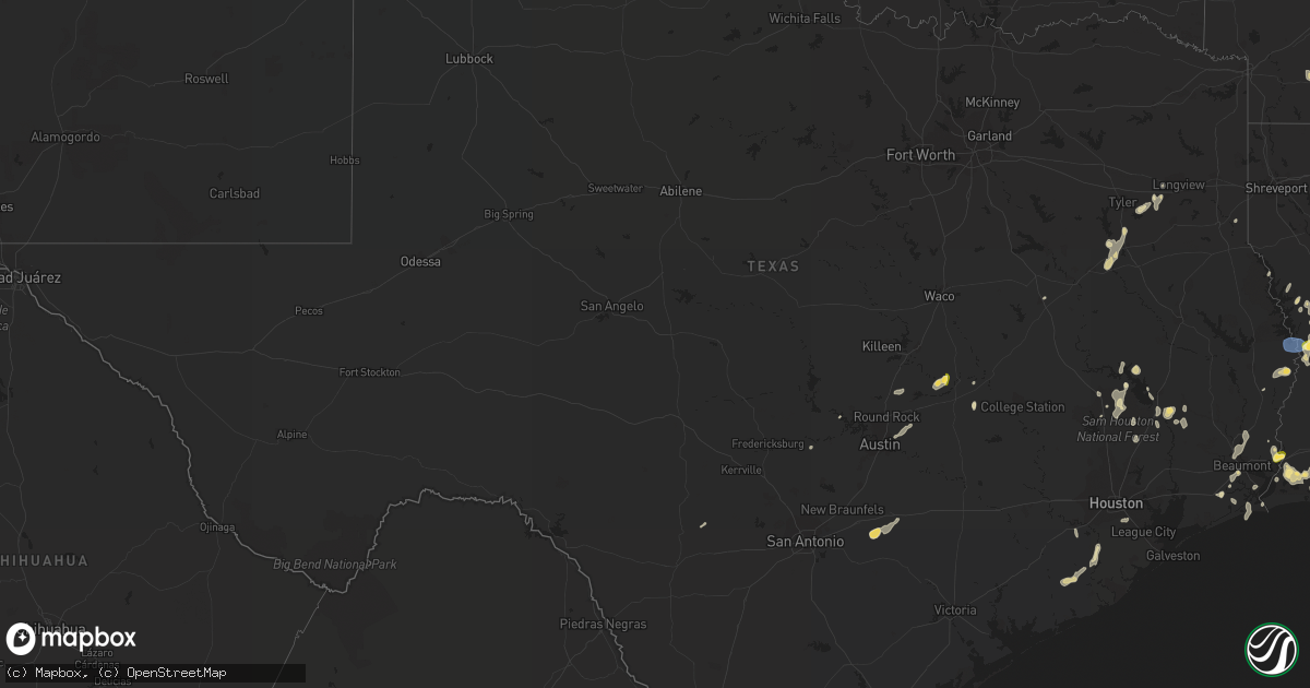
Hail Map in Texas on September 7, 2022
Get this storm
September 7 map
$229
one time, instant access
Download today. No call, no setup
Keep the $229
Bought the map and want the full workflow? Apply the entire $229 to a subscription within 7 days. None of it is wasted.
Every map, not just this one
This buys you this map. Subscription and you get every map we run, in the markets you choose from a few cities to whole states to nationwide. Plus real-time alerts the moment a storm fires.
Contact data
Name, contact info, occupancy, even credit band for addresses in the footprint. You go from where it hit to who to call.
Become the source they trust
Unlimited branding weather history reports on demand. You already have the documented answer ready for the property owner, and you are the one who showed up with it.
Property data and RoofTrace estimates
Pull up any address you have got, its value and the exact code rules for that jurisdiction, straight from One Click Code. Then RoofTrace estimates the squares, pitch, and roof value, priced the way you price.
Storm reports in Texas
Texas
| Date | Description |
|---|---|
| 09/07/20222:24 PM CDT | Several trees were downed near the wildwood circle and briarwood drive area. There was damage to two nearby homes. One of the homes had its roof pealed off. Time of eve |
| 09/07/202210:15 AM CDT | Structure fire reported near noonday lightning caused. |
| 09/07/20229:45 AM CDT | Trees reported down on cr 2288. |
| 09/07/20229:35 AM CDT | Tree just fell on a cherokee sheriff vehicle who was helping work traffic at a structure fire which was possibly caused by lightning just south of bullard tx on fm 2493 |
| 09/07/20229:30 AM CDT | Trees reported down near cr 220. |
| 09/07/20228:15 AM CDT | Home destroyed by fire probably cause lightning strike on fm 2493. |
| 09/07/20228:00 AM CDT | Trees down on sh 42 near lavertt chapel... Possible roof damage to home. |
| 09/07/20228:00 AM CDT | Updates previous tstm wnd dmg report from 3 n new london. Trees down on sh 42 near lavertt chapel... Roof damage to two homes and an outbuilding destroyed. |
| 09/07/20225:28 AM CDT | At 1028 PM CDT, a severe thunderstorm was located 12 miles north of Nixon, or 15 miles southeast of Seguin, moving south at 35 mph. HAZARD...60 mph wind gusts and quarter size hail. SOURCE...Radar indicated. IMPACT...Hail damage to vehicles is expected. Expect wind damage to roofs, siding, and trees. Locations impacted include... Stockdale, Nixon, Pandora and Leesville. |
| 09/07/20224:21 AM CDT | At 920 AM CDT, a severe thunderstorm was located near Arp, or near Whitehouse, moving southwest at 20 mph. HAZARD...60 mph wind gusts and quarter size hail. SOURCE...Radar indicated. IMPACT...Hail damage to vehicles is expected. Expect wind damage to roofs, siding, and trees. Locations impacted include... Tyler, Jacksonville, Whitehouse, Bullard, Troup, Arp, Mount Selman, Mixon, Reese, New Chapel Hill, Cuney and Teaselville. |
| 09/07/202212:45 AM CDT | At 545 PM CDT, a severe thunderstorm was located near Sabine National Wildlife, moving south at 15 mph. HAZARD...60 mph wind gusts and quarter size hail. SOURCE...Radar indicated. IMPACT...Hail damage to vehicles is expected. Expect wind damage to roofs, siding, and trees. Locations impacted include... Sabine National Wildlife, Johnsons Bayou and Constance Beach. |
| 09/06/202211:57 PM CDT | At 457 PM CDT, a severe thunderstorm was located near Cameron, moving southwest at 25 mph. HAZARD...60 mph wind gusts and quarter size hail. SOURCE...Radar indicated. IMPACT...Hail damage to vehicles is expected. Expect wind damage to roofs, siding, and trees. Locations impacted include... Cameron, Thorndale and Buckholts. |
| 09/06/202210:00 PM CDT | At 259 PM CDT, a severe thunderstorm was located near Willis, moving south at 15 mph. HAZARD...60 mph wind gusts and penny size hail. SOURCE...Radar indicated. IMPACT...Expect damage to roofs, siding, and trees. Locations impacted include... Conroe, Willis, Panorama Village, Cut And Shoot, New Waverly, Woodloch and Lake Conroe Dam. |
| 09/06/20229:42 PM CDT | At 242 PM CDT, a severe thunderstorm was located 10 miles west of Coldspring, or 15 miles northeast of Willis, moving south at 15 mph. HAZARD...60 mph wind gusts and quarter size hail. SOURCE...Radar indicated. IMPACT...Hail damage to vehicles is expected. Expect wind damage to roofs, siding, and trees. Locations impacted include... Eastern Conroe, Cut And Shoot, North Cleveland and Evergreen. |
All States Impacted by Hail Map on September 7, 2022
Cities Impacted by Hail Map on September 7, 2022
- Zwolle, LA
- Longville, LA
- Newton, TX
- Burkeville, TX
- Saratoga, TX
- Jena, LA
- Olla, LA
- Many, LA
- Hornbeck, LA
- Florien, LA
- Granger, TX
- Georgetown, TX
- Kaplan, LA
- Buckholts, TX
- Thorndale, TX
- Cameron, TX
- Davilla, TX
- Rockdale, TX
- Oakdale, LA
- Leesville, LA
- Kilgore, TX
- Maurice, LA
- Groveton, TX
- Orlando, FL
- Morriston, FL
- Utopia, TX
- Gueydan, LA
- Anacoco, LA
- Orange, TX
- Gonzales, TX
- Tyler, TX
- Arp, TX
- Jackson, AL
- Jeanerette, LA
- Atlanta, LA
- Lake Charles, LA
- Iowa, LA
- Robeline, LA
- Natchitoches, LA
- Glenmora, LA
- Elmer, LA
- Woodworth, LA
- Laurel, MS
- Beaumont, TX
- Walker, LA
- Waldo, AR
- Nixon, TX
- Leesville, TX
- Seguin, TX
- New Iberia, LA
- Carthage, TX
- Cleveland, TX
- New Llano, LA
- Huntsville, TX
- Hackberry, LA
- Buffalo, TX
- Baton Rouge, LA
- Richmond, TX
- Alexandria, LA
- Vinton, LA
- Damon, TX
- Cameron, LA
- Port Arthur, TX
- Sabine Pass, TX
- Rosharon, TX
- Caldwell, TX
- Saint Cloud, FL
- Buckner, AR
- Spring Hill, FL
- Livingston, TX
- Shepherd, TX
- Shelbyville, TX
- Rosston, AR
- Collins, MS
- Marble Falls, TX
- Spicewood, TX
- Deweyville, TX
- Jacksonville, TX
- Provencal, LA
- Deridder, LA
- Punta Gorda, FL
- Arcadia, FL
- Pointblank, TX
- Iota, LA
- Crowley, LA
- Rayne, LA
- Duson, LA
- Franklin, LA
- Mount Olive, NC
- Winnfield, LA
- Goodrich, TX
- Johnson City, TX
- Overton, TX
- Ball, LA
- Pineville, LA
- Pitkin, LA
- Elizabeth, LA
- Lena, MS
- Morgan City, LA
- New Waverly, TX
- Hamshire, TX
- Fort Polk, LA
- Cloutierville, LA
- Montgomery, LA
- Natchez, LA
- Colfax, LA
- Denham Springs, LA
- Bullard, TX
- Palestine, TX
- Troup, TX
- Frankston, TX
- Rusk, TX
- Okeechobee, FL
- Lumberton, TX
- Buna, TX
- Vidor, TX
- Saint Martinville, LA
- Maringouin, LA
- Paulding, MS
- Willis, TX
- Coldspring, TX
- Oakhurst, TX
- Melrose, LA
- Scott, LA
- Van Vleck, TX
- West Columbia, TX
- Bay City, TX
- Sweeny, TX
- Longview, TX
- Austin, TX
- Coupland, TX
- Manor, TX
- Bell City, LA
- Trinity, TX
- Dunnellon, FL
- Ochopee, FL
- Leesburg, FL
- Groveland, FL
- Howey In The Hills, FL
- North Fort Myers, FL
- Pomona Park, FL
- Crescent City, FL
- Quitman, MS
- Winnie, TX
- Houston, TX
- Pearland, TX
- Evans, LA
- Kingsbury, TX
- Fort Myers, FL
- Raynesford, MT
- Coffee Creek, MT
- Belt, MT
- Denton, MT
- Stanford, MT
- Geyser, MT


