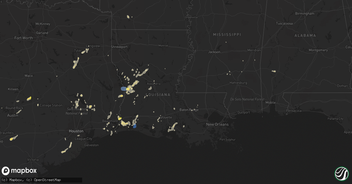
Hail Map in Louisiana on September 7, 2022
Get this storm
September 7 map
$229
one time, instant access
Download today. No call, no setup
Keep the $229
Bought the map and want the full workflow? Apply the entire $229 to a subscription within 7 days. None of it is wasted.
Every map, not just this one
This buys you this map. Subscription and you get every map we run, in the markets you choose from a few cities to whole states to nationwide. Plus real-time alerts the moment a storm fires.
Contact data
Name, contact info, occupancy, even credit band for addresses in the footprint. You go from where it hit to who to call.
Become the source they trust
Unlimited branding weather history reports on demand. You already have the documented answer ready for the property owner, and you are the one who showed up with it.
Property data and RoofTrace estimates
Pull up any address you have got, its value and the exact code rules for that jurisdiction, straight from One Click Code. Then RoofTrace estimates the squares, pitch, and roof value, priced the way you price.
Storm reports in Louisiana
Louisiana
| Date | Description |
|---|---|
| 09/07/20225:51 PM CDT | Vernon parish reports trees down on hwy 111 near jack jeane loop which resulted in power outages in the area. Time estimated by radar. |
| 09/07/20225:45 PM CDT | Trees reported down on holly hill dr. Near woodland ridge blvd. |
| 09/07/20225:40 PM CDT | Vernon parish reports several trees down on hwys 111 and 392 near the toledo bend dam. |
| 09/07/20224:24 PM CDT | Tree limbs down. |
| 09/07/20224:22 PM CDT | Tree limbs down. |
| 09/07/20224:31 AM CDT | At 931 AM CDT, a severe thunderstorm was located 7 miles south of Deberry, or 11 miles east of Carthage, moving southwest at 15 mph. HAZARD...60 mph wind gusts and quarter size hail. SOURCE...Radar indicated. IMPACT...Hail damage to vehicles is expected. Expect wind damage to roofs, siding, and trees. Locations impacted include... Carthage, Midyett, Deadwood, Front and Woods. |
| 09/07/20221:25 AM CDT | At 624 PM CDT, a severe thunderstorm was located over Newton, moving southwest at 15 mph. HAZARD...60 mph wind gusts and half dollar size hail. SOURCE...Radar indicated. IMPACT...Hail damage to vehicles is expected. Expect wind damage to roofs, siding, and trees. Locations impacted include... Newton, Kirbyville, Bon Weir, Jamestown, Trout Creek, Roganville, Junction, Stringtown and Bleakwood. |
| 09/07/202212:38 AM CDT | At 538 PM CDT, a severe thunderstorm was located over Shenandoah, or near Denham Springs, moving south at 10 mph. HAZARD...60 mph wind gusts and quarter size hail. SOURCE...Radar indicated. IMPACT...Hail damage to vehicles is expected. Expect wind damage to roofs, siding, and trees. Locations impacted include... Baton Rouge, Denham Springs, Oak Hills Place, Prairieville, Westminster, Old Jefferson, Village St. George, Inniswold and Shenandoah.This includes the following Interstates... Interstate 10 in Louisiana between mile markers 162 and 175. Interstate 12 between mile markers 2 and 11. |
| 09/07/202212:28 AM CDT | At 527 PM CDT, severe thunderstorms were located along a line extending from near Many to 6 miles southwest of Anacoco to near Rosepine, moving southwest at 35 mph. HAZARD...70 mph wind gusts and quarter size hail. SOURCE...Radar indicated. IMPACT...Hail damage to vehicles is expected. Expect considerable tree damage. Wind damage is also likely to mobile homes, roofs, and outbuildings. Locations impacted include... De Ridder, Leesville, Newton, Rosepine, Anacoco, Toledo Bend Dam, Fort Polk, Slagle, Burkeville, New Llano, Hornbeck, Browndell, Farrsville, Burr Ferry, Mayflower, Jamestown, Kurthwood, Harrisburg, Stringtown and Wiergate. |
| 09/07/202212:12 AM CDT | At 512 PM CDT, severe thunderstorms were located near Grand Lake, moving south at 15 mph. HAZARD...60 mph wind gusts and quarter size hail. SOURCE...Radar indicated. IMPACT...Hail damage to vehicles is expected. Expect wind damage to roofs, siding, and trees. Locations impacted include... Cameron, Grand Lake, Grand Chenier, Hackberry, Holly Beach, Hacketts Corner, Creole, Sweet Lake, Gibbstown and Rutherford Beach. |
| 09/07/202212:10 AM CDT | At 509 PM CDT, a severe thunderstorm was located near Toomey, or near Orange, moving south at 20 mph. HAZARD...60 mph wind gusts and half dollar size hail. SOURCE...Radar indicated. IMPACT...Hail damage to vehicles is expected. Expect wind damage to roofs, siding, and trees. Locations impacted include... Orange, Bridge City, West Orange, Vinton, Sabine National Wildlife, Pinehurst, Toomey, Orangefield and Forest Heights.This includes the following highways... Interstate 10 in Texas between mile markers 880 and 872. Interstate 10 in Louisiana between mile markers 1 and 7. |
| 09/06/202211:57 PM CDT | At 457 PM CDT, severe thunderstorms were located along a line extending from near Krotz Springs to near Atchafalaya National Wildlife Refuge, moving south at 15 mph. HAZARD...60 mph wind gusts and quarter size hail. SOURCE...Radar indicated. IMPACT...Hail damage to vehicles is expected. Expect wind damage to roofs, siding, and trees. Locations impacted include... Henderson, Atchafalaya Welcome Center, Butte La Rose and Atchafalaya National Wildlife Refuge.This includes Interstate 10 in Louisiana between mile markers 117 and126. |
| 09/06/202211:51 PM CDT | At 451 PM CDT, a severe thunderstorm was located near Atchafalaya National Wildlife Refuge, or 8 miles southeast of Krotz Springs, moving south at 30 mph. HAZARD...60 mph wind gusts and quarter size hail. SOURCE...Radar indicated. IMPACT...Hail damage to vehicles is expected. Expect wind damage to roofs, siding, and trees. Locations impacted include... Ramah.This includes Interstate 10 in Louisiana between mile markers 128 and135. |
| 09/06/202211:13 PM CDT | At 413 PM CDT, severe thunderstorms were located along a line extending from 13 miles southwest of Campti to near Natchitoches to near Montgomery to near Colfax, moving southwest at 15 mph. HAZARD...60 mph wind gusts and penny size hail. SOURCE...Radar indicated. IMPACT...Expect damage to roofs, siding, and trees. Locations impacted include... Natchitoches, Many, Colfax, Montgomery, Provencal, Natchez, Robeline, Cloutierville, Melrose, Bellwood, Chopin, St. Maurice, Flora, Cypress, Bermuda, Aloha, Gorum, Marthaville and Hagewood. |
| 09/06/202210:37 PM CDT | At 336 PM CDT, a severe thunderstorm was located 11 miles east of Montgomery, or 13 miles south of Winnfield, moving south at 10 mph. HAZARD...60 mph wind gusts and penny size hail. SOURCE...Radar indicated. IMPACT...Expect damage to roofs, siding, and trees. Locations impacted include... Colfax, Montgomery, Atlanta, Melrose, Lake Iatt, Aloha and Williana. |
| 09/06/20227:27 PM CDT | Wind damage to powerlines resulting in power outages. Time estimated by radar. |
All States Impacted by Hail Map on September 7, 2022
Cities Impacted by Hail Map on September 7, 2022
- Zwolle, LA
- Longville, LA
- Newton, TX
- Burkeville, TX
- Saratoga, TX
- Jena, LA
- Olla, LA
- Many, LA
- Hornbeck, LA
- Florien, LA
- Granger, TX
- Georgetown, TX
- Kaplan, LA
- Buckholts, TX
- Thorndale, TX
- Cameron, TX
- Davilla, TX
- Rockdale, TX
- Oakdale, LA
- Leesville, LA
- Kilgore, TX
- Maurice, LA
- Groveton, TX
- Orlando, FL
- Morriston, FL
- Utopia, TX
- Gueydan, LA
- Anacoco, LA
- Orange, TX
- Gonzales, TX
- Tyler, TX
- Arp, TX
- Jackson, AL
- Jeanerette, LA
- Atlanta, LA
- Lake Charles, LA
- Iowa, LA
- Robeline, LA
- Natchitoches, LA
- Glenmora, LA
- Elmer, LA
- Woodworth, LA
- Laurel, MS
- Beaumont, TX
- Walker, LA
- Waldo, AR
- Nixon, TX
- Leesville, TX
- Seguin, TX
- New Iberia, LA
- Carthage, TX
- Cleveland, TX
- New Llano, LA
- Huntsville, TX
- Hackberry, LA
- Buffalo, TX
- Baton Rouge, LA
- Richmond, TX
- Alexandria, LA
- Vinton, LA
- Damon, TX
- Cameron, LA
- Port Arthur, TX
- Sabine Pass, TX
- Rosharon, TX
- Caldwell, TX
- Saint Cloud, FL
- Buckner, AR
- Spring Hill, FL
- Livingston, TX
- Shepherd, TX
- Shelbyville, TX
- Rosston, AR
- Collins, MS
- Marble Falls, TX
- Spicewood, TX
- Deweyville, TX
- Jacksonville, TX
- Provencal, LA
- Deridder, LA
- Punta Gorda, FL
- Arcadia, FL
- Pointblank, TX
- Iota, LA
- Crowley, LA
- Rayne, LA
- Duson, LA
- Franklin, LA
- Mount Olive, NC
- Winnfield, LA
- Goodrich, TX
- Johnson City, TX
- Overton, TX
- Ball, LA
- Pineville, LA
- Pitkin, LA
- Elizabeth, LA
- Lena, MS
- Morgan City, LA
- New Waverly, TX
- Hamshire, TX
- Fort Polk, LA
- Cloutierville, LA
- Montgomery, LA
- Natchez, LA
- Colfax, LA
- Denham Springs, LA
- Bullard, TX
- Palestine, TX
- Troup, TX
- Frankston, TX
- Rusk, TX
- Okeechobee, FL
- Lumberton, TX
- Buna, TX
- Vidor, TX
- Saint Martinville, LA
- Maringouin, LA
- Paulding, MS
- Willis, TX
- Coldspring, TX
- Oakhurst, TX
- Melrose, LA
- Scott, LA
- Van Vleck, TX
- West Columbia, TX
- Bay City, TX
- Sweeny, TX
- Longview, TX
- Austin, TX
- Coupland, TX
- Manor, TX
- Bell City, LA
- Trinity, TX
- Dunnellon, FL
- Ochopee, FL
- Leesburg, FL
- Groveland, FL
- Howey In The Hills, FL
- North Fort Myers, FL
- Pomona Park, FL
- Crescent City, FL
- Quitman, MS
- Winnie, TX
- Houston, TX
- Pearland, TX
- Evans, LA
- Kingsbury, TX
- Fort Myers, FL
- Raynesford, MT
- Coffee Creek, MT
- Belt, MT
- Denton, MT
- Stanford, MT
- Geyser, MT


