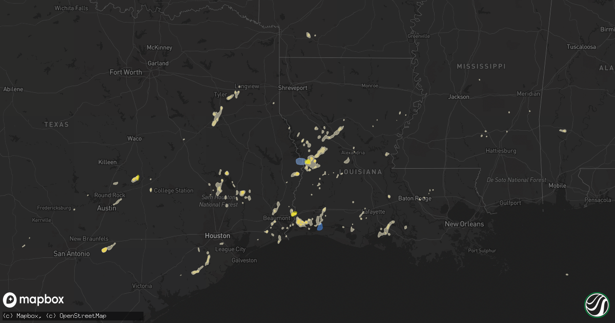
Hail Map on September 7, 2022
Get this storm
September 7 map
$229
one time, instant access
Download today. No call, no setup
Keep the $229
Bought the map and want the full workflow? Apply the entire $229 to a subscription within 7 days. None of it is wasted.
Every map, not just this one
This buys you this map. Subscription and you get every map we run, in the markets you choose from a few cities to whole states to nationwide. Plus real-time alerts the moment a storm fires.
Contact data
Name, contact info, occupancy, even credit band for addresses in the footprint. You go from where it hit to who to call.
Become the source they trust
Unlimited branding weather history reports on demand. You already have the documented answer ready for the property owner, and you are the one who showed up with it.
Property data and RoofTrace estimates
Pull up any address you have got, its value and the exact code rules for that jurisdiction, straight from One Click Code. Then RoofTrace estimates the squares, pitch, and roof value, priced the way you price.
States Impacted by Hail Map on September 7, 2022
Storm reports
North Carolina
| Date | Description |
|---|---|
| 09/07/20222:30 PM CDT | A few large trees were reported down se of calypso near north duplin high school. |
Montana
| Date | Description |
|---|---|
| 09/07/20226:56 PM CDT | Mesonet aw hotel. |
| 09/07/20226:42 PM CDT | Mesonet station mtyep mdt - gary cooper bridge - dearborn. |
| 09/07/20226:30 PM CDT | Greenfield irrigation. |
| 09/07/20226:28 PM CDT | Corrects previous non-tstm wnd gst report from 8 ssw wolf creek. Mesonet station mtsbn sieben flats - mdt. |
| 09/07/20226:28 PM CDT | Gust of 58.2mph recorded and relayed via ambient weather. |
| 09/07/20226:28 PM CDT | Via ambientweather. |
| 09/07/20226:25 PM CDT | Asos station khln helena airport. |
| 09/07/20226:21 PM CDT | Awos station k1gm golf. |
| 09/07/20225:59 PM CDT | A local report indicates 58 MPH wind near 4 N BILLINGS |
| 09/07/20225:56 PM CDT | Mesonet station mtmdp macdonald pass |
| 09/07/20225:09 PM CDT | A local report indicates 58 MPH wind near 10 E MOLT |
| 09/07/20224:45 PM CDT | A local report indicates 63 MPH wind near 5 N RAPLEJE |
| 09/07/20224:40 PM CDT | A local report indicates 58 MPH wind near 2 ENE HARLOWTON |
| 09/07/20224:15 PM CDT | A local report indicates 62 MPH wind near BIG TIMBER |
| 09/07/20222:55 PM CDT | A local report indicates 58 MPH wind near 4 NNE MCALLISTER |
| 09/07/20223:32 AM CDT | At 830 PM MDT, a severe thunderstorm was located over Zortman, moving northeast at 45 mph. HAZARD...60 mph wind gusts. SOURCE...Radar indicated. IMPACT...Expect damage to roofs, siding, and trees. Locations impacted include... Malta, Zortman, Dodson, Fourchette, Phillips, Wagner, Landusky, Sun Prairie and Fred Robinson Bridge. |
| 09/07/20221:32 AM CDT | At 630 PM MDT, severe thunderstorms were located along a line extending from 16 miles north of Black Eagle to 19 miles southwest of Geyser to near White Sulphur Springs, moving east at 40 mph. HAZARD...70 mph wind gusts, and widespread blowing dust. SOURCE...Radar indicated. IMPACT...Expect considerable tree damage. Damage is likely to mobile homes, roofs, and outbuildings. Visibility will be reduced to less than 2 miles at times in blowing dust. Locations impacted include... Great Falls, Fort Benton, White Sulphur Springs, Stanford, Belt, Geraldine, Highwood, Black Eagle, Geyser, Carter, Neihart, Floweree, Windham, Sapphire Village, Stockett, Utica, Shonkin, Loma, Checkerboard and Raynesford. |
| 09/07/202212:57 AM CDT | At 556 PM MDT, severe thunderstorms were located along a line extending from near Dutton to 23 miles southeast of Cascade to 10 miles southwest of Townsend, moving east at 50 mph. HAZARD...70 mph wind gusts. SOURCE...Radar indicated. IMPACT...Expect considerable tree damage. Damage is likely to mobile homes, roofs, and outbuildings. Locations impacted include... Great Falls, Townsend, Fort Benton, White Sulphur Springs, Cascade, Stanford, Belt, Dutton, Fort Shaw, Highwood, Black Eagle, Geyser, Fort Shaw, Power, Carter, Neihart, Fort Logan On The Smith River, Floweree, Eden and Sapphire Village. |
| 09/07/202212:28 AM CDT | At 528 PM MDT, severe thunderstorms were located along a line extending from near Wolf Creek to 10 miles north of East Helena to 6 miles southwest of Montana City, moving northeast at 55 mph. HAZARD...70 mph wind gusts. SOURCE...Radar indicated. IMPACT...Expect considerable tree damage. Damage is likely to mobile homes, roofs, and outbuildings. Locations impacted include... Helena, East Helena, Montana City, York, Alhambra, Clancy, Black Sandy State Park and Goose Bay. |
| 09/06/202211:28 PM CDT | At 427 PM MDT, severe thunderstorms were located along a line extending from 10 miles northeast of Ryegate to 9 miles northwest of Pryor, moving northeast at 35 mph. HAZARD...60 mph wind gusts. SOURCE...Radar indicated. Gusts to 58 mph have been reported along this line. IMPACT...Expect damage to roofs, siding, and trees. Severe thunderstorms will be near... Billings around 435 PM MDT Roundup around 510 PM MDT.Other locations impacted by these severe thunderstorms include Laurel, Pompeys Pillar, Acton, Musselshell, Lavina, Klein, Broadview and Comanche.This replaces the warning previously in effect for this area. |
| 09/06/202211:02 PM CDT | At 401 PM MDT, a severe thunderstorm was located over Joliet, or 16 miles southeast of Columbus, moving east at 40 mph. HAZARD...60 mph wind gusts. SOURCE...Radar indicated. IMPACT...Expect damage to roofs, siding, and trees. Locations impacted include... Laurel, Joliet, Fromberg, Pryor, Billings West End, Edgar, Boyd, Roberts, Silesia, Cooney Reservoir State Park, Park City and Rockvale. |
| 09/06/20228:40 PM CDT | Measured via the big sky field asos site. |
| 09/06/20228:00 PM CDT | A local report indicates 62 MPH wind near 6 ESE EMIGRANT |
| 09/06/20227:59 PM CDT | A local report indicates 61 MPH wind near 4 SSE WHATLEY |
| 09/06/20227:52 PM CDT | Awos station k1gm golf. |
| 09/06/20227:14 PM CDT | Site kmtgreat49. |
| 09/06/20227:09 PM CDT | Site kmttowns11. |
| 09/06/20227:07 PM CDT | Corrects previous tstm wnd gst report from 5 wsw great falls. Great falls airport asos measured 60 mph wind gust. |
| 09/06/20227:07 PM CDT | Great falls airport asos measured 58 mph wind gust. |
| 09/06/20227:00 PM CDT | Trained spotter reported two sheds damaged... One leaned up against grain bins and the other with its roof torn off. A fabric carport was also damage. Estimated wind 60 |
Texas
| Date | Description |
|---|---|
| 09/07/20222:24 PM CDT | Several trees were downed near the wildwood circle and briarwood drive area. There was damage to two nearby homes. One of the homes had its roof pealed off. Time of eve |
| 09/07/202210:15 AM CDT | Structure fire reported near noonday lightning caused. |
| 09/07/20229:45 AM CDT | Trees reported down on cr 2288. |
| 09/07/20229:35 AM CDT | Tree just fell on a cherokee sheriff vehicle who was helping work traffic at a structure fire which was possibly caused by lightning just south of bullard tx on fm 2493 |
| 09/07/20229:30 AM CDT | Trees reported down near cr 220. |
| 09/07/20228:15 AM CDT | Home destroyed by fire probably cause lightning strike on fm 2493. |
| 09/07/20228:00 AM CDT | Updates previous tstm wnd dmg report from 3 n new london. Trees down on sh 42 near lavertt chapel... Roof damage to two homes and an outbuilding destroyed. |
| 09/07/20228:00 AM CDT | Trees down on sh 42 near lavertt chapel... Possible roof damage to home. |
| 09/07/20225:28 AM CDT | At 1028 PM CDT, a severe thunderstorm was located 12 miles north of Nixon, or 15 miles southeast of Seguin, moving south at 35 mph. HAZARD...60 mph wind gusts and quarter size hail. SOURCE...Radar indicated. IMPACT...Hail damage to vehicles is expected. Expect wind damage to roofs, siding, and trees. Locations impacted include... Stockdale, Nixon, Pandora and Leesville. |
| 09/07/20224:21 AM CDT | At 920 AM CDT, a severe thunderstorm was located near Arp, or near Whitehouse, moving southwest at 20 mph. HAZARD...60 mph wind gusts and quarter size hail. SOURCE...Radar indicated. IMPACT...Hail damage to vehicles is expected. Expect wind damage to roofs, siding, and trees. Locations impacted include... Tyler, Jacksonville, Whitehouse, Bullard, Troup, Arp, Mount Selman, Mixon, Reese, New Chapel Hill, Cuney and Teaselville. |
| 09/07/202212:45 AM CDT | At 545 PM CDT, a severe thunderstorm was located near Sabine National Wildlife, moving south at 15 mph. HAZARD...60 mph wind gusts and quarter size hail. SOURCE...Radar indicated. IMPACT...Hail damage to vehicles is expected. Expect wind damage to roofs, siding, and trees. Locations impacted include... Sabine National Wildlife, Johnsons Bayou and Constance Beach. |
| 09/06/202211:57 PM CDT | At 457 PM CDT, a severe thunderstorm was located near Cameron, moving southwest at 25 mph. HAZARD...60 mph wind gusts and quarter size hail. SOURCE...Radar indicated. IMPACT...Hail damage to vehicles is expected. Expect wind damage to roofs, siding, and trees. Locations impacted include... Cameron, Thorndale and Buckholts. |
| 09/06/202210:00 PM CDT | At 259 PM CDT, a severe thunderstorm was located near Willis, moving south at 15 mph. HAZARD...60 mph wind gusts and penny size hail. SOURCE...Radar indicated. IMPACT...Expect damage to roofs, siding, and trees. Locations impacted include... Conroe, Willis, Panorama Village, Cut And Shoot, New Waverly, Woodloch and Lake Conroe Dam. |
| 09/06/20229:42 PM CDT | At 242 PM CDT, a severe thunderstorm was located 10 miles west of Coldspring, or 15 miles northeast of Willis, moving south at 15 mph. HAZARD...60 mph wind gusts and quarter size hail. SOURCE...Radar indicated. IMPACT...Hail damage to vehicles is expected. Expect wind damage to roofs, siding, and trees. Locations impacted include... Eastern Conroe, Cut And Shoot, North Cleveland and Evergreen. |
Oregon
| Date | Description |
|---|---|
| 09/07/20226:07 PM CDT | A local report indicates 78 MPH wind near 1 NNW ROME |
| 09/07/20225:36 PM CDT | A local report indicates 60 MPH wind near 5 E BURNS |
| 09/07/20221:41 AM CDT | At 640 PM MDT/540 PM PDT/, severe thunderstorms were located along a line extending from Richland to near Homedale, moving east-northeast at 55 mph. HAZARD...70 mph wind gusts. SOURCE...Radar indicated. IMPACT...Expect considerable tree damage. Damage is likely to mobile homes, roofs, and outbuildings. Severe thunderstorms will be near... Halfway, Richland and Carson around 550 PM PDT. Cambridge around 650 PM MDT. Oxbow Dam and Brownlee Dam around 600 PM PDT. Goodrich and Brownlee Reservoir around 700 PM MDT. Emmett, Eagle, Council and Bear around 710 PM MDT. Sweet, Horseshoe Bend, Montour and Lost Valley Reservoir around 720 PM MDT. McCall, Gardena, Ola and New Meadows around 730 PM MDT. |
| 09/07/20221:08 AM CDT | At 606 PM MDT/506 PM PDT/, severe thunderstorms were located along a line extending from near Brogan to Castro Ridge, moving east at 60 mph. HAZARD...70 mph wind gusts. SOURCE...Radar indicated. IMPACT...Expect considerable tree damage. Damage is likely to mobile homes, roofs, and outbuildings. Severe thunderstorms will be near... Castro Ridge, Parsnip Peak, Little Grassy Reservoir and Antelope Reservoir around 610 PM MDT. Reynolds, South Mountain, Henley Basin and Black Warrior Mountain around 620 PM MDT. Weiser, Silver City, Murphy and Melba around 630 PM MDT. Payette, Ontario, Parma and Emmett around 640 PM MDT. |
| 09/06/202211:29 PM CDT | At 428 PM PDT, severe thunderstorms were located along a line extending from near Castle Rock to near Crowley, moving east at 45 mph. HAZARD...70 mph wind gusts. SOURCE...Radar indicated. IMPACT...Expect considerable tree damage. Damage is likely to mobile homes, roofs, and outbuildings. Severe thunderstorms will be near... Monument Peak around 530 PM MDT. Westfall Butte, Copeland Butte, Jonesboro and Red Butte around 540 PM MDT. Westfall, Knottingham Butte and Brushy Hollow around 550 PM MDT. Harper, Buckbrush Poison Butte, Pelican Point and Freezeout Mountain around 600 PM MDT. Brogan, Sugarloaf Butte, Board Corral Mountain and Jamieson around 610 PM MDT. |
| 09/06/202210:46 PM CDT | At 344 PM PDT, severe thunderstorms were located along a line extending from near Calamity Butte to 6 miles southeast of Riddle Mountain, moving east at 55 mph. Burns Airport reported a wind gust of 60 mph. HAZARD...60 mph wind gusts. SOURCE...Radar indicated. IMPACT...Expect damage to roofs, siding, and trees. Severe thunderstorms will be near... Battle Mountain around 400 PM PDT. Drewsey around 410 PM PDT. Saddle Butte around 510 PM MDT. Juntura around 520 PM MDT. Birch Creek Campground around 530 PM MDT. |
| 09/06/20227:53 PM CDT | Roof damage from large fallen tree. |
Alabama
| Date | Description |
|---|---|
| 09/07/20225:48 PM CDT | Transformer and power pole blown down on blvd ave. |
| 09/07/20225:27 PM CDT | Corrects previous tstm wnd dmg report from york. Around 25 trees down in york... At least two on homes... As well as numerous powerlines. Tin roof blown off of a commer |
| 09/07/20225:27 PM CDT | Numerous trees and powerlines down in and around york. Initial reports of a building with significant damage in york. |
| 09/06/20227:15 PM CDT | Multiple reports of trees down. One along old line rd about 4 miles north of us84... Another by the intersection of allen walker rd & rabbit creek rd.... And one near t |
Mississippi
| Date | Description |
|---|---|
| 09/07/20225:00 PM CDT | Heavy rains and strong winds knocked down a tree on a home in columbus. No injuries were reported. |
| 09/07/20224:52 PM CDT | Tree was uprooted at ridgecrest in madison from heavy winds that blew through the area earlier today. Local streets and neighborhoods are littered with smaller limbs an |
| 09/07/20224:11 PM CDT | Corrects previous tstm wnd dmg report from 1 ne ridgeland. Tree was uprooted at ridgecrest in madison from heavy winds that blew through the area earlier today. Local s |
| 09/07/20223:10 PM CDT | Corrects previous tstm wnd dmg report from 1 wsw columbus. Heavy rains and strong winds knocked down a tree on a home in columbus. No injuries were reported. |
Louisiana
| Date | Description |
|---|---|
| 09/07/20225:51 PM CDT | Vernon parish reports trees down on hwy 111 near jack jeane loop which resulted in power outages in the area. Time estimated by radar. |
| 09/07/20225:45 PM CDT | Trees reported down on holly hill dr. Near woodland ridge blvd. |
| 09/07/20225:40 PM CDT | Vernon parish reports several trees down on hwys 111 and 392 near the toledo bend dam. |
| 09/07/20224:24 PM CDT | Tree limbs down. |
| 09/07/20224:22 PM CDT | Tree limbs down. |
| 09/07/20224:31 AM CDT | At 931 AM CDT, a severe thunderstorm was located 7 miles south of Deberry, or 11 miles east of Carthage, moving southwest at 15 mph. HAZARD...60 mph wind gusts and quarter size hail. SOURCE...Radar indicated. IMPACT...Hail damage to vehicles is expected. Expect wind damage to roofs, siding, and trees. Locations impacted include... Carthage, Midyett, Deadwood, Front and Woods. |
| 09/07/20221:25 AM CDT | At 624 PM CDT, a severe thunderstorm was located over Newton, moving southwest at 15 mph. HAZARD...60 mph wind gusts and half dollar size hail. SOURCE...Radar indicated. IMPACT...Hail damage to vehicles is expected. Expect wind damage to roofs, siding, and trees. Locations impacted include... Newton, Kirbyville, Bon Weir, Jamestown, Trout Creek, Roganville, Junction, Stringtown and Bleakwood. |
| 09/07/202212:38 AM CDT | At 538 PM CDT, a severe thunderstorm was located over Shenandoah, or near Denham Springs, moving south at 10 mph. HAZARD...60 mph wind gusts and quarter size hail. SOURCE...Radar indicated. IMPACT...Hail damage to vehicles is expected. Expect wind damage to roofs, siding, and trees. Locations impacted include... Baton Rouge, Denham Springs, Oak Hills Place, Prairieville, Westminster, Old Jefferson, Village St. George, Inniswold and Shenandoah.This includes the following Interstates... Interstate 10 in Louisiana between mile markers 162 and 175. Interstate 12 between mile markers 2 and 11. |
| 09/07/202212:28 AM CDT | At 527 PM CDT, severe thunderstorms were located along a line extending from near Many to 6 miles southwest of Anacoco to near Rosepine, moving southwest at 35 mph. HAZARD...70 mph wind gusts and quarter size hail. SOURCE...Radar indicated. IMPACT...Hail damage to vehicles is expected. Expect considerable tree damage. Wind damage is also likely to mobile homes, roofs, and outbuildings. Locations impacted include... De Ridder, Leesville, Newton, Rosepine, Anacoco, Toledo Bend Dam, Fort Polk, Slagle, Burkeville, New Llano, Hornbeck, Browndell, Farrsville, Burr Ferry, Mayflower, Jamestown, Kurthwood, Harrisburg, Stringtown and Wiergate. |
| 09/07/202212:12 AM CDT | At 512 PM CDT, severe thunderstorms were located near Grand Lake, moving south at 15 mph. HAZARD...60 mph wind gusts and quarter size hail. SOURCE...Radar indicated. IMPACT...Hail damage to vehicles is expected. Expect wind damage to roofs, siding, and trees. Locations impacted include... Cameron, Grand Lake, Grand Chenier, Hackberry, Holly Beach, Hacketts Corner, Creole, Sweet Lake, Gibbstown and Rutherford Beach. |
| 09/07/202212:10 AM CDT | At 509 PM CDT, a severe thunderstorm was located near Toomey, or near Orange, moving south at 20 mph. HAZARD...60 mph wind gusts and half dollar size hail. SOURCE...Radar indicated. IMPACT...Hail damage to vehicles is expected. Expect wind damage to roofs, siding, and trees. Locations impacted include... Orange, Bridge City, West Orange, Vinton, Sabine National Wildlife, Pinehurst, Toomey, Orangefield and Forest Heights.This includes the following highways... Interstate 10 in Texas between mile markers 880 and 872. Interstate 10 in Louisiana between mile markers 1 and 7. |
| 09/06/202211:57 PM CDT | At 457 PM CDT, severe thunderstorms were located along a line extending from near Krotz Springs to near Atchafalaya National Wildlife Refuge, moving south at 15 mph. HAZARD...60 mph wind gusts and quarter size hail. SOURCE...Radar indicated. IMPACT...Hail damage to vehicles is expected. Expect wind damage to roofs, siding, and trees. Locations impacted include... Henderson, Atchafalaya Welcome Center, Butte La Rose and Atchafalaya National Wildlife Refuge.This includes Interstate 10 in Louisiana between mile markers 117 and126. |
| 09/06/202211:51 PM CDT | At 451 PM CDT, a severe thunderstorm was located near Atchafalaya National Wildlife Refuge, or 8 miles southeast of Krotz Springs, moving south at 30 mph. HAZARD...60 mph wind gusts and quarter size hail. SOURCE...Radar indicated. IMPACT...Hail damage to vehicles is expected. Expect wind damage to roofs, siding, and trees. Locations impacted include... Ramah.This includes Interstate 10 in Louisiana between mile markers 128 and135. |
| 09/06/202211:13 PM CDT | At 413 PM CDT, severe thunderstorms were located along a line extending from 13 miles southwest of Campti to near Natchitoches to near Montgomery to near Colfax, moving southwest at 15 mph. HAZARD...60 mph wind gusts and penny size hail. SOURCE...Radar indicated. IMPACT...Expect damage to roofs, siding, and trees. Locations impacted include... Natchitoches, Many, Colfax, Montgomery, Provencal, Natchez, Robeline, Cloutierville, Melrose, Bellwood, Chopin, St. Maurice, Flora, Cypress, Bermuda, Aloha, Gorum, Marthaville and Hagewood. |
| 09/06/202210:37 PM CDT | At 336 PM CDT, a severe thunderstorm was located 11 miles east of Montgomery, or 13 miles south of Winnfield, moving south at 10 mph. HAZARD...60 mph wind gusts and penny size hail. SOURCE...Radar indicated. IMPACT...Expect damage to roofs, siding, and trees. Locations impacted include... Colfax, Montgomery, Atlanta, Melrose, Lake Iatt, Aloha and Williana. |
| 09/06/20227:27 PM CDT | Wind damage to powerlines resulting in power outages. Time estimated by radar. |
Idaho
| Date | Description |
|---|---|
| 09/07/20222:32 PM CDT | Mesonet station crii1 cotton ridge recorded a gust to 60 mph associated with a developing thunderstorm. |
| 09/06/202211:28 PM CDT | At 427 PM PDT, severe thunderstorms were located along a line extending from near Saddle Butte to near Overshoe Pass, moving northeast at 35 mph. HAZARD...70 mph wind gusts and blowing dust significantly reducing visibility. SOURCE...Radar indicated. IMPACT...Expect considerable tree damage. Damage is likely to mobile homes, roofs, and outbuildings. Severe thunderstorms will be near... Saddle Butte and Owyhee Butte around 530 PM MDT. Iron Point and Arock around 540 PM MDT. Jackies Butte, Peacock Lake and Crooked Creek State Park around 550 PM MDT. Rome, Coffeepot Crater, Five Points and Scott Reservoir around 600 PM MDT. Grassy Mountain, Mustang Butte, Mouse Trap Butte and Mahogany Mountain around 610 PM MDT. |
Florida
| Date | Description |
|---|---|
| 09/07/20221:31 AM CDT | At 631 PM EDT, a severe thunderstorm was located near Howey-In-the-hills, moving southeast at 10 mph. HAZARD...60 mph wind gusts and nickel size hail. SOURCE...Radar indicated. IMPACT...Expect damage to roofs, siding, and trees. Locations impacted include... Tavares, Howey-In-the-hills, Lake Harris, Astatula and Little Lake Harris. |
| 09/07/202212:52 AM CDT | At 551 PM EDT, a severe thunderstorm was located near Southwest Florida Airport, or near Fort Myers, and is nearly stationary. HAZARD...60 mph wind gusts and quarter size hail. SOURCE...Radar indicated. IMPACT...Hail damage to vehicles is expected. Expect wind damage to roofs, siding, and trees. Locations impacted include... Fort Myers, Page Park, Page Field Airport, East Dunbar, Fort Myers Villas, Pine Manor, Tice, Southwest Florida Airport, Gateway and Buckingham. |
| 09/07/202212:13 AM CDT | At 513 PM EDT, a severe thunderstorm was located 9 miles northwest of Big Cypress National Preserve, or 18 miles northeast of Everglades City, moving northwest at 10 mph. HAZARD...60 mph wind gusts and quarter size hail. SOURCE...Radar indicated. IMPACT...Hail damage to vehicles is expected. Expect wind damage to roofs, siding, and trees. Locations impacted include... Big Cypress National Preserve, Deep Lake and Miles City. |
Cities Impacted by Hail Map on September 7, 2022
- Zwolle, LA
- Longville, LA
- Newton, TX
- Burkeville, TX
- Saratoga, TX
- Jena, LA
- Olla, LA
- Many, LA
- Hornbeck, LA
- Florien, LA
- Granger, TX
- Georgetown, TX
- Kaplan, LA
- Buckholts, TX
- Thorndale, TX
- Cameron, TX
- Davilla, TX
- Rockdale, TX
- Oakdale, LA
- Leesville, LA
- Kilgore, TX
- Maurice, LA
- Groveton, TX
- Orlando, FL
- Morriston, FL
- Utopia, TX
- Gueydan, LA
- Anacoco, LA
- Orange, TX
- Gonzales, TX
- Tyler, TX
- Arp, TX
- Jackson, AL
- Jeanerette, LA
- Atlanta, LA
- Lake Charles, LA
- Iowa, LA
- Robeline, LA
- Natchitoches, LA
- Glenmora, LA
- Elmer, LA
- Woodworth, LA
- Laurel, MS
- Beaumont, TX
- Walker, LA
- Waldo, AR
- Nixon, TX
- Leesville, TX
- Seguin, TX
- New Iberia, LA
- Carthage, TX
- Cleveland, TX
- New Llano, LA
- Huntsville, TX
- Hackberry, LA
- Buffalo, TX
- Baton Rouge, LA
- Richmond, TX
- Alexandria, LA
- Vinton, LA
- Damon, TX
- Cameron, LA
- Port Arthur, TX
- Sabine Pass, TX
- Rosharon, TX
- Caldwell, TX
- Saint Cloud, FL
- Buckner, AR
- Spring Hill, FL
- Livingston, TX
- Shepherd, TX
- Shelbyville, TX
- Rosston, AR
- Collins, MS
- Marble Falls, TX
- Spicewood, TX
- Deweyville, TX
- Jacksonville, TX
- Provencal, LA
- Deridder, LA
- Punta Gorda, FL
- Arcadia, FL
- Pointblank, TX
- Iota, LA
- Crowley, LA
- Rayne, LA
- Duson, LA
- Franklin, LA
- Mount Olive, NC
- Winnfield, LA
- Goodrich, TX
- Johnson City, TX
- Overton, TX
- Ball, LA
- Pineville, LA
- Pitkin, LA
- Elizabeth, LA
- Lena, MS
- Morgan City, LA
- New Waverly, TX
- Hamshire, TX
- Fort Polk, LA
- Cloutierville, LA
- Montgomery, LA
- Natchez, LA
- Colfax, LA
- Denham Springs, LA
- Bullard, TX
- Palestine, TX
- Troup, TX
- Frankston, TX
- Rusk, TX
- Okeechobee, FL
- Lumberton, TX
- Buna, TX
- Vidor, TX
- Saint Martinville, LA
- Maringouin, LA
- Paulding, MS
- Willis, TX
- Coldspring, TX
- Oakhurst, TX
- Melrose, LA
- Scott, LA
- Van Vleck, TX
- West Columbia, TX
- Bay City, TX
- Sweeny, TX
- Longview, TX
- Austin, TX
- Coupland, TX
- Manor, TX
- Bell City, LA
- Trinity, TX
- Dunnellon, FL
- Ochopee, FL
- Leesburg, FL
- Groveland, FL
- Howey In The Hills, FL
- North Fort Myers, FL
- Pomona Park, FL
- Crescent City, FL
- Quitman, MS
- Winnie, TX
- Houston, TX
- Pearland, TX
- Evans, LA
- Kingsbury, TX
- Fort Myers, FL
- Raynesford, MT
- Coffee Creek, MT
- Belt, MT
- Denton, MT
- Stanford, MT
- Geyser, MT