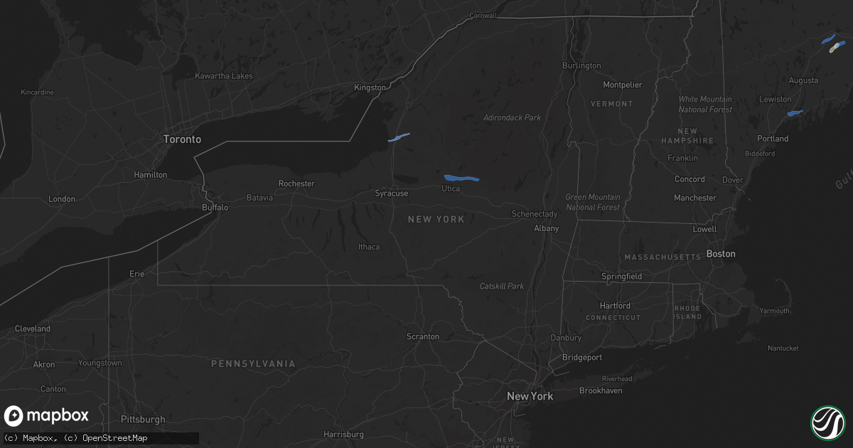
Hail Map in New York on September 6, 2021
Get this storm
September 6 map
$229
one time, instant access
Download today. No call, no setup
Keep the $229
Bought the map and want the full workflow? Apply the entire $229 to a subscription within 7 days. None of it is wasted.
Every map, not just this one
This buys you this map. Subscription and you get every map we run, in the markets you choose from a few cities to whole states to nationwide. Plus real-time alerts the moment a storm fires.
Contact data
Name, contact info, occupancy, even credit band for addresses in the footprint. You go from where it hit to who to call.
Become the source they trust
Unlimited branding weather history reports on demand. You already have the documented answer ready for the property owner, and you are the one who showed up with it.
Property data and RoofTrace estimates
Pull up any address you have got, its value and the exact code rules for that jurisdiction, straight from One Click Code. Then RoofTrace estimates the squares, pitch, and roof value, priced the way you price.
Storm reports in New York
New York
| Date | Description |
|---|---|
| 09/06/202110:30 AM CDT | Downed tree blocking rte 169 between parkhurst rd and davis rd. |
| 09/06/202110:28 AM CDT | 2 downed trees which fell on rental cottages in the herkimer diamond mines koa campground. No injuries. |
| 09/06/202110:24 AM CDT | Large tree limb down |
| 09/06/202110:15 AM CDT | Tree blocking partridge hill road |
| 09/06/20219:15 AM CDT | Roof damage to a barn and several trees down. |
| 09/06/20218:56 AM CDT | Social media report of several trees and power lines down. |
| 09/06/20216:15 AM CDT | At 1115 AM EDT, severe thunderstorms were located along a line extending from near Poland to 6 miles southwest of Newport to near Utica, moving east southeast at 50 mph. HAZARD...60 mph wind gusts and penny size hail. SOURCE...Radar indicated. IMPACT...Expect damage to roofs, siding, and trees. Locations impacted include... Gloversville, Johnstown, Ilion, Herkimer, Little Falls, Canajoharie, Mohawk, Frankfort, Fort Plain, Dolgeville, St. Johnsville, Ephratah, Newport, Stratford, Middleville, Poland, Cold Brook, Caroga Lake, Caroga Lake Public Campground and Russia. |
All States Impacted by Hail Map on September 6, 2021
Cities Impacted by Hail Map on September 6, 2021
- Ogema, MN
- Wagon Mound, NM
- Park Rapids, MN
- Ponsford, MN
- Hayward, WI
- Spooner, WI
- Stone Lake, WI
- Springbrook, WI
- Crystal Falls, MI
- Junction, TX
- Ada, MN
- Gary, MN
- Marenisco, MI
- San Saba, TX
- Buda, TX
- Leander, TX
- Twin Valley, MN
- Grasston, MN
- Pine City, MN
- Richland Springs, TX
- Merrifield, MN
- Pequot Lakes, MN
- Waubun, MN
- Bastrop, TX
- Webster, WI
- Danbury, WI
- Bruce Crossing, MI
- Cherokee, TX
- Johnson City, TX
- Lockhart, TX
- Kyle, TX
- Osage, MN
- Brook Park, MN
- Mora, MN
- Iron River, MI
- Trout Creek, MI
- Comfort, TX
- Boerne, TX
- Dunbar, WI
- Park Falls, WI
- Ulen, MN
- Borup, MN
- Austin, TX
- Blackduck, MN
- Tenstrike, MN
- Hines, MN
- Menominee, MI
- Vernon, TX
- Burnham, ME
- Troy, ME
- Wallace, MI
- Stephenson, MI
- White Earth, MN
- Iron Belt, WI
- Iron Mountain, MI
- Florence, WI
- Rhinelander, WI
- Tomahawk, WI
- Irma, WI
- Fayetteville, TX
- Hackensack, MN
- Mason, TX
- Green Bay, WI
- Columbus, TX
- Solano, NM
- Trementina, NM
- Weimar, TX
- Clayton, NM
- Del Valle, TX
- Schulenburg, TX
- Sister Bay, WI
- Baileys Harbor, WI
- Hallettsville, TX
- Santa Anna, TX
- Mercer, WI
- Lac Du Flambeau, WI
- Flatonia, TX
- Fish Creek, WI
- Gleason, WI
- Ephraim, WI
- Ellison Bay, WI
- Ewen, MI
- Deerbrook, WI
- Georgetown, TX
- San Antonio, TX
- Harshaw, WI
- Couderay, WI
- Hinckley, MN
- Trego, WI
- Glidden, WI
- Butternut, WI
- Blanco, TX
- Manchaca, TX
- West Point, TX
- Texline, TX
- Paint Rock, TX
- Dale, TX
- Waelder, TX
- Pound, WI
- Crivitz, WI
- Coleman, TX
- Gouldbusk, TX
- Muldoon, TX
- Roy, NM
- Westwego, LA
- Unity, ME
- Rochelle, TX
- Driftwood, TX
- Wimberley, TX
- Christoval, TX
- Lanse, MI
- Lawn, TX
- Braham, MN
- Niagara, WI
- San Marcos, TX
- Mahnomen, MN
- Bath, ME
- Topsham, ME
- Brunswick, ME
- Woolwich, ME
- Palmyra, ME
- Pittsfield, ME
- Clinton, ME
- Canaan, ME
- Detroit, ME
- Plymouth, ME
- Dixmont, ME
- Winter, WI
- Baraga, MI
- Pelkie, MI
- Michigamme, MI
- Lorraine, NY
- Pulaski, NY
- Sandy Creek, NY
- Mannsville, NY
- Lacona, NY
- Poland, NY
- Utica, NY
- Marcy, NY
- Little Falls, NY
- Barneveld, NY
- Salisbury Center, NY
- Holland Patent, NY
- Newport, NY
- Rome, NY
- Stittville, NY


