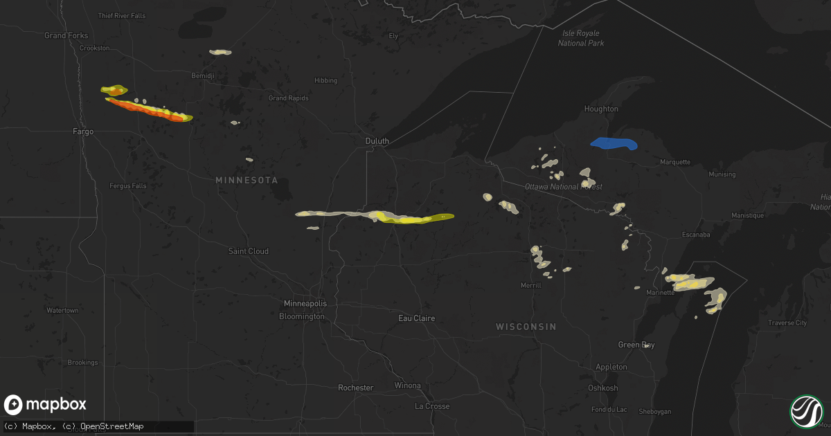
Hail Map on September 6, 2021
Get this storm
September 6 map
$229
one time, instant access
Download today. No call, no setup
Keep the $229
Bought the map and want the full workflow? Apply the entire $229 to a subscription within 7 days. None of it is wasted.
Every map, not just this one
This buys you this map. Subscription and you get every map we run, in the markets you choose from a few cities to whole states to nationwide. Plus real-time alerts the moment a storm fires.
Contact data
Name, contact info, occupancy, even credit band for addresses in the footprint. You go from where it hit to who to call.
Become the source they trust
Unlimited branding weather history reports on demand. You already have the documented answer ready for the property owner, and you are the one who showed up with it.
Property data and RoofTrace estimates
Pull up any address you have got, its value and the exact code rules for that jurisdiction, straight from One Click Code. Then RoofTrace estimates the squares, pitch, and roof value, priced the way you price.
States Impacted by Hail Map on September 6, 2021
Storm reports
Maine
| Date | Description |
|---|---|
| 09/06/20214:48 PM CDT | Trees and power lines down. Report from penobscot county rcc. Time estimated based on radar. |
| 09/06/20214:45 PM CDT | Trees down on powerlines. The report was received via facebook. Time estimated based on radar. Power still out as of 10 pm. |
| 09/06/20214:40 PM CDT | A large pine tree fell on a vehicle in glenburn. Time estimated. |
| 09/06/20214:18 PM CDT | Trees and power lines down. Report from penobscot county rcc. Time estimated based on radar. |
| 09/06/20214:10 PM CDT | Trees and power lines down. |
| 09/06/20213:45 PM CDT | Trees and powerlines down. |
| 09/06/20213:40 PM CDT | Large tree down on a house on route 196 in topsham. Time estimated based on radar. |
| 09/06/20213:40 PM CDT | Large tree down on wires on route 201 in topsham. Time estimated based on radar. |
| 09/06/20213:39 PM CDT | Power pole snapped along with downed trees in the vicinity of andrea street. |
| 09/06/20213:39 PM CDT | Numerous trees down on wires... Homes... And vehicles east side of topsham. |
| 09/06/20213:33 PM CDT | Numerous trees down near 100 school road. |
| 09/06/20211:51 AM CDT | At 651 PM EDT, a severe thunderstorm was located 9 miles east of Island Falls, or 16 miles southwest of Houlton, moving east at 35 mph. HAZARD...60 mph wind gusts and quarter size hail. SOURCE...Radar indicated. IMPACT...Minor hail damage to vehicles is possible. Expect wind damage to trees and power lines. Locations impacted include... Houlton, Hodgdon, Island Falls, Amity, Cary Plantation, Linneus, Oakfield, New Limerick, Cary, Forkstown and North Amity. |
| 09/06/202112:20 AM CDT | At 520 PM EDT, a severe thunderstorm was located near Orneville, or 8 miles east of Dover-Foxcroft, moving east at 15 mph. HAZARD...60 mph wind gusts and quarter size hail. SOURCE...Radar indicated. IMPACT...Minor hail damage to vehicles is possible. Expect wind damage to trees and power lines. Locations impacted include... Dover-Foxcroft, Howland, Milo, Orneville, Lake View Plantation, Enfield, Charleston, Bradford, Garland, Lagrange, Sebec, Passadumkeag, Atkinson, Argyle, Medford, Maxfield, Seboeis and Boyd Lake. |
| 09/06/202112:10 AM CDT | At 510 PM EDT, a severe thunderstorm was located near Unity, or near Thorndike, moving east at 25 mph. HAZARD...60 mph wind gusts and quarter size hail. SOURCE...Radar indicated. IMPACT...Minor hail damage to vehicles is possible. Expect wind damage to trees and power lines. Locations impacted include... Hampden, Hermon, Kenduskeag, Glenburn, Orrington, Levant, Carmel, Newburgh, Plymouth, Etna and Dixmont. |
| 09/06/202112:08 AM CDT | At 508 PM EDT, severe thunderstorms were located along a line extending from 12 miles north of Pittsfield to Thorndike to China to 6 miles southwest of Palermo, moving east at 45 mph. HAZARD...60 mph wind gusts and nickel size hail. SOURCE...Radar indicated. IMPACT...Expect damage to roofs, siding, and trees. Locations impacted include... Belfast, Searsport, Pittsfield, Thorndike, China, Clinton, Liberty, Winterport, Palermo, Stockton Springs, Unity, Prospect, Knox, Benton, Canaan, Albion, Hartland, Burnham, Frankfort and Brooks. |
| 09/05/202111:33 PM CDT | At 433 PM EDT, severe thunderstorms were located along a line extending from 6 miles southwest of Winthrop to 6 miles northwest of Topsham to Freeport, moving east at 30 mph. HAZARD...60 mph wind gusts and nickel size hail. SOURCE...Radar indicated. IMPACT...Expect damage to roofs, siding, and trees. Locations impacted include... Brunswick, Augusta, Bath, Gardiner, Topsham, Wiscasset, Freeport, Litchfield, Farmingdale, Manchester, Hallowell, Georgetown, Woolwich, Winthrop, Lisbon, Harpswell, Durham, Boothbay, Bowdoin and Bowdoinham. |
Wisconsin
| Date | Description |
|---|---|
| 09/06/20216:16 AM CDT | Trees down in peninsula state park. Report from the dnr. Delayed report. Time estimated by radar. |
Michigan
| Date | Description |
|---|---|
| 09/06/20214:00 AM CDT | A couple of trees down. |
| 09/06/20213:25 AM CDT | Corrects previous tstm wnd dmg report from lanse-after calling village of lanse... It is believed that lightning caused damage to a piece of equipment in a local substa |
| 09/06/20213:25 AM CDT | Corrects previous tstm wnd dmg report from lanse-after calling village of lanse... It is believed that lightning caused damage to a piece of equipment in a local substa |
Minnesota
| Date | Description |
|---|---|
| 09/06/20216:30 AM CDT | At 1130 PM CDT, a severe thunderstorm was located over southwestern White Earth Nation, or 22 miles north of Detroit Lakes, moving east at 55 mph. HAZARD...Half dollar size hail. SOURCE...Radar indicated. IMPACT...Damage to vehicles is expected. This severe thunderstorm will be near... White Earth around 1135 PM CDT. Tulaby Lake and Many Point Lake around 1150 PM CDT.Other locations in the path of this severe thunderstorm include BadMedicine Lake, Long Lost Lake and Two Inlets. |
| 09/06/20214:50 AM CDT | At 949 PM CDT, a severe thunderstorm was located near Gary, or 40 miles northeast of Fargo, moving east at 45 mph. HAZARD...Quarter size hail. SOURCE...Radar indicated. IMPACT...Damage to vehicles is expected. This severe thunderstorm will be near... Gary around 955 PM CDT. Waukon and Faith around 1005 PM CDT.Other locations in the path of this severe thunderstorm includeMahnomen, Bejou, Beaulieu, Island Lake in Mahnomen County, Pine Bendand Mahkonce. |
| 09/06/20214:17 AM CDT | At 917 PM CDT, a severe thunderstorm was located over Blackduck, or 23 miles northeast of Bemidji, moving east at 45 mph. HAZARD...Quarter size hail. SOURCE...Radar indicated. IMPACT...Damage to vehicles is expected. This severe thunderstorm will be near... Funkley around 925 PM CDT. |
| 09/06/202112:14 AM CDT | Large branches broken down onto roadways across southern portions of two inlets state forest. Time esatimated based on radar. |
| 09/05/202111:59 PM CDT | Reports of large hail... Heavy rain... And very strong winds across east central round lake and northeast pine point townships. Hail was mainly nickel to quarter sized |
| 09/05/202110:33 PM CDT | Several trees reported down in the area near laporte... Exact locations unclear. Including one tree over residential deck. Time estimated from radar. |
| 09/05/202110:06 PM CDT | 8 to 12 inch tree branches down from thunderstorm winds. Time estimated from radar. |
| 09/05/20219:20 PM CDT | Numerous dime to nickle sized hail and a few quarter sized hail... Along with brief heavy rain and very strong winds. |
New Mexico
| Date | Description |
|---|---|
| 09/06/20212:19 AM CDT | At 719 PM MDT, a severe thunderstorm was located near Texline, or 8 miles southeast of Clayton, moving south at 15 mph. HAZARD...60 mph wind gusts and quarter size hail. SOURCE...Radar indicated. IMPACT...Hail damage to vehicles is expected. Expect wind damage to roofs, siding, and trees. Locations impacted include... Clayton and Sedan. |
| 09/06/20211:42 AM CDT | At 642 PM MDT, a severe thunderstorm was located 14 miles southwest of Roy, or 20 miles southeast of Wagon Mound, moving south at 20 mph. HAZARD...60 mph wind gusts and quarter size hail. SOURCE...Radar indicated. IMPACT...Hail damage to vehicles is expected. Expect wind damage to roofs, siding, and trees. This severe thunderstorm will remain over mainly rural areas of north central San Miguel, west central Harding and southeastern Mora Counties. |
| 09/06/20211:03 AM CDT | At 602 PM MDT, a severe thunderstorm was located near Mills, or 20 miles east of Wagon Mound, moving southeast at 15 mph. HAZARD...60 mph wind gusts and quarter size hail. SOURCE...Radar indicated. IMPACT...Hail damage to vehicles is expected. Expect wind damage to roofs, siding, and trees. Locations impacted include... Roy, Mills, Chicosa Lake State Park and Solano. |
| 09/05/20217:12 PM CDT | A local report indicates 1.00 inch wind near SENECA |
Florida
| Date | Description |
|---|---|
| 09/06/202112:48 AM CDT | At 547 PM EDT, a severe thunderstorm was located over Country Walk, or near Kendall, moving southeast at 15 mph. HAZARD...60 mph wind gusts and penny size hail. SOURCE...Radar indicated. IMPACT...Expect damage to roofs, siding, and trees. Locations impacted include... The Redland, Kendall, Richmond West, Country Walk and Kendale Lakes. |
Vermont
| Date | Description |
|---|---|
| 09/05/20218:36 PM CDT | At 136 PM EDT, a severe thunderstorm was located over East Warren, moving east at 45 mph. HAZARD...60 mph wind gusts and quarter size hail. SOURCE...Radar indicated. IMPACT...Minor hail damage to vehicles is possible. Expect wind damage to trees and powerlines. Locations impacted include... Barre, Middlebury, Montpelier, Braintree Hill, Plainfield, Orange, Chelsea, Websterville, Lincoln, Randolph, Waitsfield, Berlin, Fayston, Granville, Barre Town, Northfield Village, Tunbridge, Hancock, Washington and Warren. |
New York
| Date | Description |
|---|---|
| 09/06/202110:30 AM CDT | Downed tree blocking rte 169 between parkhurst rd and davis rd. |
| 09/06/202110:28 AM CDT | 2 downed trees which fell on rental cottages in the herkimer diamond mines koa campground. No injuries. |
| 09/06/202110:24 AM CDT | Large tree limb down |
| 09/06/202110:15 AM CDT | Tree blocking partridge hill road |
| 09/06/20219:15 AM CDT | Roof damage to a barn and several trees down. |
| 09/06/20218:56 AM CDT | Social media report of several trees and power lines down. |
| 09/06/20216:15 AM CDT | At 1115 AM EDT, severe thunderstorms were located along a line extending from near Poland to 6 miles southwest of Newport to near Utica, moving east southeast at 50 mph. HAZARD...60 mph wind gusts and penny size hail. SOURCE...Radar indicated. IMPACT...Expect damage to roofs, siding, and trees. Locations impacted include... Gloversville, Johnstown, Ilion, Herkimer, Little Falls, Canajoharie, Mohawk, Frankfort, Fort Plain, Dolgeville, St. Johnsville, Ephratah, Newport, Stratford, Middleville, Poland, Cold Brook, Caroga Lake, Caroga Lake Public Campground and Russia. |
Texas
| Date | Description |
|---|---|
| 09/06/20213:20 PM CDT | Multiple tree branches down across the city of bastrop. Various branches measuring 2 to 5 inches in diameter. |
| 09/06/20212:30 PM CDT | Roof damage at the full moon saloon at intersection of sh 123 and fm 1978. Time estimated via radar. |
| 09/05/202111:17 PM CDT | At 417 PM CDT, a severe thunderstorm was located near Buda, moving southwest at 20 mph. HAZARD...60 mph wind gusts and quarter size hail. SOURCE...Radar indicated. IMPACT...Hail damage to vehicles is expected. Expect wind damage to roofs, siding, and trees. Locations impacted include... San Marcos, Kyle, Buda, Dripping Springs, Wimberley, Canyon Lake Dam, Canyon Lake, Woodcreek, Martindale, Uhland, Mustang Ridge, Niederwald, Bear Creek, Zorn, Driftwood, Manchaca, Mountain City, Hays, Hunter and San Marcos Regional Airport. |
Cities Impacted by Hail Map on September 6, 2021
- Ogema, MN
- Wagon Mound, NM
- Park Rapids, MN
- Ponsford, MN
- Hayward, WI
- Spooner, WI
- Stone Lake, WI
- Springbrook, WI
- Crystal Falls, MI
- Junction, TX
- Ada, MN
- Gary, MN
- Marenisco, MI
- San Saba, TX
- Buda, TX
- Leander, TX
- Twin Valley, MN
- Grasston, MN
- Pine City, MN
- Richland Springs, TX
- Merrifield, MN
- Pequot Lakes, MN
- Waubun, MN
- Bastrop, TX
- Webster, WI
- Danbury, WI
- Bruce Crossing, MI
- Cherokee, TX
- Johnson City, TX
- Lockhart, TX
- Kyle, TX
- Osage, MN
- Brook Park, MN
- Mora, MN
- Iron River, MI
- Trout Creek, MI
- Comfort, TX
- Boerne, TX
- Dunbar, WI
- Park Falls, WI
- Ulen, MN
- Borup, MN
- Austin, TX
- Blackduck, MN
- Tenstrike, MN
- Hines, MN
- Menominee, MI
- Vernon, TX
- Burnham, ME
- Troy, ME
- Wallace, MI
- Stephenson, MI
- White Earth, MN
- Iron Belt, WI
- Iron Mountain, MI
- Florence, WI
- Rhinelander, WI
- Tomahawk, WI
- Irma, WI
- Fayetteville, TX
- Hackensack, MN
- Mason, TX
- Green Bay, WI
- Columbus, TX
- Solano, NM
- Trementina, NM
- Weimar, TX
- Clayton, NM
- Del Valle, TX
- Schulenburg, TX
- Sister Bay, WI
- Baileys Harbor, WI
- Hallettsville, TX
- Santa Anna, TX
- Mercer, WI
- Lac Du Flambeau, WI
- Flatonia, TX
- Fish Creek, WI
- Gleason, WI
- Ephraim, WI
- Ellison Bay, WI
- Ewen, MI
- Deerbrook, WI
- Georgetown, TX
- San Antonio, TX
- Harshaw, WI
- Couderay, WI
- Hinckley, MN
- Trego, WI
- Glidden, WI
- Butternut, WI
- Blanco, TX
- Manchaca, TX
- West Point, TX
- Texline, TX
- Paint Rock, TX
- Dale, TX
- Waelder, TX
- Pound, WI
- Crivitz, WI
- Coleman, TX
- Gouldbusk, TX
- Muldoon, TX
- Roy, NM
- Westwego, LA
- Unity, ME
- Rochelle, TX
- Driftwood, TX
- Wimberley, TX
- Christoval, TX
- Lanse, MI
- Lawn, TX
- Braham, MN
- Niagara, WI
- San Marcos, TX
- Mahnomen, MN
- Bath, ME
- Topsham, ME
- Brunswick, ME
- Woolwich, ME
- Palmyra, ME
- Pittsfield, ME
- Clinton, ME
- Canaan, ME
- Detroit, ME
- Plymouth, ME
- Dixmont, ME
- Winter, WI
- Baraga, MI
- Pelkie, MI
- Michigamme, MI
- Lorraine, NY
- Pulaski, NY
- Sandy Creek, NY
- Mannsville, NY
- Lacona, NY
- Poland, NY
- Utica, NY
- Marcy, NY
- Little Falls, NY
- Barneveld, NY
- Salisbury Center, NY
- Holland Patent, NY
- Newport, NY
- Rome, NY
- Stittville, NY