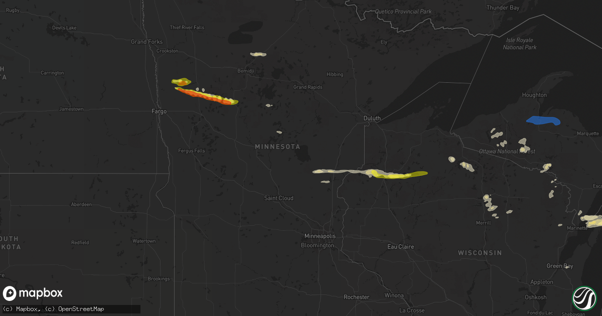
Hail Map in Minnesota on September 6, 2021
Get this storm
September 6 map
$229
one time, instant access
Download today. No call, no setup
Keep the $229
Bought the map and want the full workflow? Apply the entire $229 to a subscription within 7 days. None of it is wasted.
Every map, not just this one
This buys you this map. Subscription and you get every map we run, in the markets you choose from a few cities to whole states to nationwide. Plus real-time alerts the moment a storm fires.
Contact data
Name, contact info, occupancy, even credit band for addresses in the footprint. You go from where it hit to who to call.
Become the source they trust
Unlimited branding weather history reports on demand. You already have the documented answer ready for the property owner, and you are the one who showed up with it.
Property data and RoofTrace estimates
Pull up any address you have got, its value and the exact code rules for that jurisdiction, straight from One Click Code. Then RoofTrace estimates the squares, pitch, and roof value, priced the way you price.
Storm reports in Minnesota
Minnesota
| Date | Description |
|---|---|
| 09/06/20216:30 AM CDT | At 1130 PM CDT, a severe thunderstorm was located over southwestern White Earth Nation, or 22 miles north of Detroit Lakes, moving east at 55 mph. HAZARD...Half dollar size hail. SOURCE...Radar indicated. IMPACT...Damage to vehicles is expected. This severe thunderstorm will be near... White Earth around 1135 PM CDT. Tulaby Lake and Many Point Lake around 1150 PM CDT.Other locations in the path of this severe thunderstorm include BadMedicine Lake, Long Lost Lake and Two Inlets. |
| 09/06/20214:50 AM CDT | At 949 PM CDT, a severe thunderstorm was located near Gary, or 40 miles northeast of Fargo, moving east at 45 mph. HAZARD...Quarter size hail. SOURCE...Radar indicated. IMPACT...Damage to vehicles is expected. This severe thunderstorm will be near... Gary around 955 PM CDT. Waukon and Faith around 1005 PM CDT.Other locations in the path of this severe thunderstorm includeMahnomen, Bejou, Beaulieu, Island Lake in Mahnomen County, Pine Bendand Mahkonce. |
| 09/06/20214:17 AM CDT | At 917 PM CDT, a severe thunderstorm was located over Blackduck, or 23 miles northeast of Bemidji, moving east at 45 mph. HAZARD...Quarter size hail. SOURCE...Radar indicated. IMPACT...Damage to vehicles is expected. This severe thunderstorm will be near... Funkley around 925 PM CDT. |
| 09/06/202112:14 AM CDT | Large branches broken down onto roadways across southern portions of two inlets state forest. Time esatimated based on radar. |
| 09/05/202111:59 PM CDT | Reports of large hail... Heavy rain... And very strong winds across east central round lake and northeast pine point townships. Hail was mainly nickel to quarter sized |
| 09/05/202110:33 PM CDT | Several trees reported down in the area near laporte... Exact locations unclear. Including one tree over residential deck. Time estimated from radar. |
| 09/05/202110:06 PM CDT | 8 to 12 inch tree branches down from thunderstorm winds. Time estimated from radar. |
| 09/05/20219:20 PM CDT | Numerous dime to nickle sized hail and a few quarter sized hail... Along with brief heavy rain and very strong winds. |
All States Impacted by Hail Map on September 6, 2021
Cities Impacted by Hail Map on September 6, 2021
- Ogema, MN
- Wagon Mound, NM
- Park Rapids, MN
- Ponsford, MN
- Hayward, WI
- Spooner, WI
- Stone Lake, WI
- Springbrook, WI
- Crystal Falls, MI
- Junction, TX
- Ada, MN
- Gary, MN
- Marenisco, MI
- San Saba, TX
- Buda, TX
- Leander, TX
- Twin Valley, MN
- Grasston, MN
- Pine City, MN
- Richland Springs, TX
- Merrifield, MN
- Pequot Lakes, MN
- Waubun, MN
- Bastrop, TX
- Webster, WI
- Danbury, WI
- Bruce Crossing, MI
- Cherokee, TX
- Johnson City, TX
- Lockhart, TX
- Kyle, TX
- Osage, MN
- Brook Park, MN
- Mora, MN
- Iron River, MI
- Trout Creek, MI
- Comfort, TX
- Boerne, TX
- Dunbar, WI
- Park Falls, WI
- Ulen, MN
- Borup, MN
- Austin, TX
- Blackduck, MN
- Tenstrike, MN
- Hines, MN
- Menominee, MI
- Vernon, TX
- Burnham, ME
- Troy, ME
- Wallace, MI
- Stephenson, MI
- White Earth, MN
- Iron Belt, WI
- Iron Mountain, MI
- Florence, WI
- Rhinelander, WI
- Tomahawk, WI
- Irma, WI
- Fayetteville, TX
- Hackensack, MN
- Mason, TX
- Green Bay, WI
- Columbus, TX
- Solano, NM
- Trementina, NM
- Weimar, TX
- Clayton, NM
- Del Valle, TX
- Schulenburg, TX
- Sister Bay, WI
- Baileys Harbor, WI
- Hallettsville, TX
- Santa Anna, TX
- Mercer, WI
- Lac Du Flambeau, WI
- Flatonia, TX
- Fish Creek, WI
- Gleason, WI
- Ephraim, WI
- Ellison Bay, WI
- Ewen, MI
- Deerbrook, WI
- Georgetown, TX
- San Antonio, TX
- Harshaw, WI
- Couderay, WI
- Hinckley, MN
- Trego, WI
- Glidden, WI
- Butternut, WI
- Blanco, TX
- Manchaca, TX
- West Point, TX
- Texline, TX
- Paint Rock, TX
- Dale, TX
- Waelder, TX
- Pound, WI
- Crivitz, WI
- Coleman, TX
- Gouldbusk, TX
- Muldoon, TX
- Roy, NM
- Westwego, LA
- Unity, ME
- Rochelle, TX
- Driftwood, TX
- Wimberley, TX
- Christoval, TX
- Lanse, MI
- Lawn, TX
- Braham, MN
- Niagara, WI
- San Marcos, TX
- Mahnomen, MN
- Bath, ME
- Topsham, ME
- Brunswick, ME
- Woolwich, ME
- Palmyra, ME
- Pittsfield, ME
- Clinton, ME
- Canaan, ME
- Detroit, ME
- Plymouth, ME
- Dixmont, ME
- Winter, WI
- Baraga, MI
- Pelkie, MI
- Michigamme, MI
- Lorraine, NY
- Pulaski, NY
- Sandy Creek, NY
- Mannsville, NY
- Lacona, NY
- Poland, NY
- Utica, NY
- Marcy, NY
- Little Falls, NY
- Barneveld, NY
- Salisbury Center, NY
- Holland Patent, NY
- Newport, NY
- Rome, NY
- Stittville, NY


