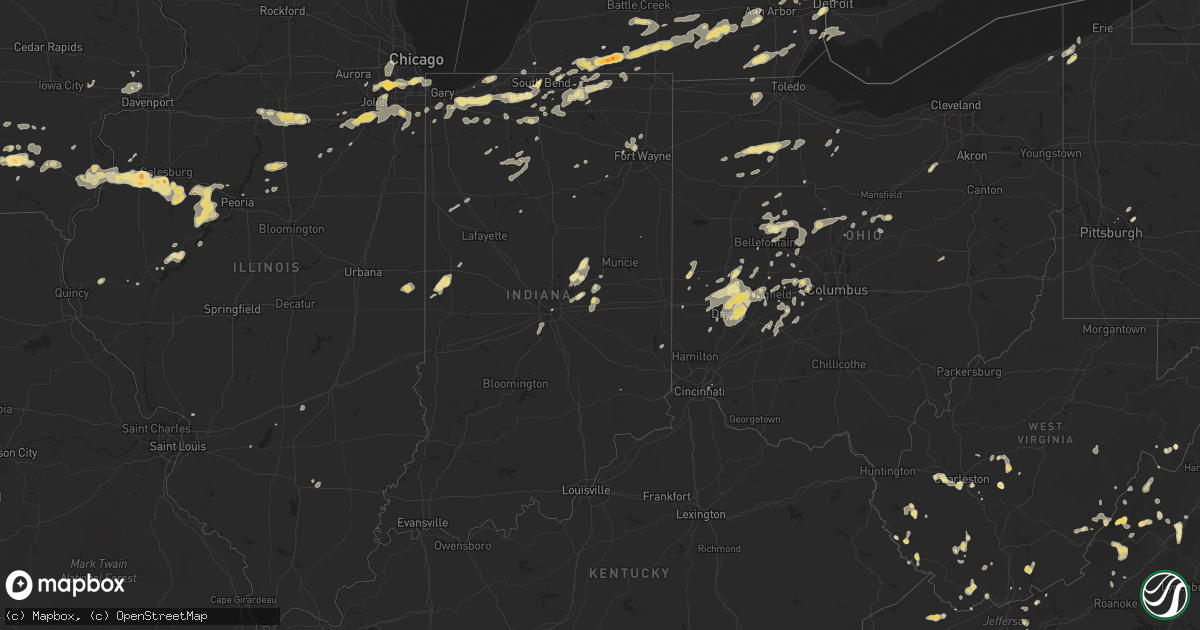
Hail Map in Michigan on September 3, 2011
Get this storm
September 3 map
$229
one time, instant access
Download today. No call, no setup
Keep the $229
Bought the map and want the full workflow? Apply the entire $229 to a subscription within 7 days. None of it is wasted.
Every map, not just this one
This buys you this map. Subscription and you get every map we run, in the markets you choose from a few cities to whole states to nationwide. Plus real-time alerts the moment a storm fires.
Contact data
Name, contact info, occupancy, even credit band for addresses in the footprint. You go from where it hit to who to call.
Become the source they trust
Unlimited branding weather history reports on demand. You already have the documented answer ready for the property owner, and you are the one who showed up with it.
Property data and RoofTrace estimates
Pull up any address you have got, its value and the exact code rules for that jurisdiction, straight from One Click Code. Then RoofTrace estimates the squares, pitch, and roof value, priced the way you price.
Storm reports in Michigan
Michigan
| Date | Description |
|---|---|
| 09/03/20116:50 PM CDT | Arm-sized tree branch down. |
| 09/03/20116:46 PM CDT | Large tree in road |
| 09/03/20116:00 PM CDT | 4 to 6 inch diameter tree limb down. Estimated 60 mph wind on columbia lake. |
| 09/03/20115:50 PM CDT | Trees and power lines down |
| 09/03/20115:50 PM CDT | Damage to structures at river rouge days festival. 8 to 10 injuries reported by police...none life threatening. Multiple festival tents blown over. Vender trailers move |
| 09/03/20115:48 PM CDT | Multiple large tree limbs down between tripp and folks on moscow. |
| 09/03/20115:35 PM CDT | Two trees down. Time estimated from radar |
| 09/03/20115:30 PM CDT | Power lines and trees down |
| 09/03/20115:27 PM CDT | Tree down across hadley rd and herring road |
| 09/03/20115:25 PM CDT | Tree down at squires and genesee road along with sheet metal from barn at squires and jonesville road. |
| 09/03/20115:23 PM CDT | A local report indicates 1.00 inch wind near QUINCY |
| 09/03/20115:20 PM CDT | At corner of jonesville road and squires road |
| 09/03/20115:10 PM CDT | Numerous trees down in the northern half of the county |
| 09/03/20115:08 PM CDT | Tree down on camper with 2 occupants. No injuries. Minor damage to cars and trailers from fallen tree limbs |
| 09/03/20115:05 PM CDT | 3 trees down |
| 09/03/20115:05 PM CDT | A local report indicates 1.00 inch wind near 1 NE EAST LEROY |
| 09/03/20115:00 PM CDT | Tree down blocking road |
| 09/03/20115:00 PM CDT | A local report indicates 60 MPH wind near 1 W COLDWATER |
| 09/03/20114:35 PM CDT | Tree down on power lines. Power out in the area |
| 09/03/20114:27 PM CDT | Tree down on car on m66 just south of maystead rd |
| 09/03/20114:15 PM CDT | Report relayed by media |
| 09/03/201110:07 AM CDT | Powerlines reported down. |
| 09/03/20119:42 AM CDT | Powerlines reported down. |
| 09/03/20119:40 AM CDT | Numerous trees and powerlines down in the city. |
| 09/03/20119:25 AM CDT | Multiple trees and power lines down. Lightning struck central dispatchs communications tower...they have no radio communications. |
| 09/03/20119:25 AM CDT | Several large maple trees blown down. |
| 09/03/20119:05 AM CDT | Pea sized hail. Wind est at 60 mph. Siding torn off building. Lot of 2 -3 inch limbs down. |
| 09/03/20118:53 AM CDT | 2 healthy one foot diameter trees snapped near the base. |
| 09/03/20118:35 AM CDT | Scattered healthy trees and limbs down. |
| 09/03/20118:16 AM CDT | Many trees and power lines reported down across the north of montcalm county. |
| 09/03/20118:15 AM CDT | Few trees and wires down no significant damage. |
| 09/03/20118:10 AM CDT | Wind estimated 60 to 70 mph. Numerous trees down and blocking roadway. |
| 09/03/20117:55 AM CDT | Numerous 6 in tree limbs down. Some healthy. Green house roof blown off. |
| 09/03/20117:37 AM CDT | A local report indicates 1.75 inch wind near 2 E WINN |
| 09/03/20117:35 AM CDT | Numerous trees and wires down in the area of the cities of newaygo and grant. |
| 09/03/20117:25 AM CDT | Numerous trees and wires down across county. |
| 09/03/20117:20 AM CDT | 2 trees down norther kent county. 1 at 16 mile rd. 1 at sargent rd. |
| 09/03/20117:00 AM CDT | 2 trees down in grand haven. |
| 09/02/201111:25 PM CDT | Trees reported town in oregon township. |
| 09/02/20118:15 PM CDT | Trees and powerlines reported down in ira township. Reports of trees through houses. Powerlines reported down near the m-29/bethuy intersection. |
| 09/02/20117:41 PM CDT | Multiple reports of 60 mph wind estimates and power outages through royal oak and madison heights. |
| 09/02/20117:02 PM CDT | 8 inch diameter tree down. |
All States Impacted by Hail Map on September 3, 2011
Cities Impacted by Hail Map on September 3, 2011
- Deerfield, MI
- Blissfield, MI
- Palmyra, MI
- Amma, WV
- Clendenin, WV
- Batavia, IA
- Fairfield, IA
- Greenville, VA
- Clarksburg, MD
- Boyds, MD
- Lock Haven, PA
- Mill Hall, PA
- Gardner, IL
- Goshen, IN
- Middlebury, IN
- Ashburn, VA
- Malden, IL
- La Moille, IL
- New Baltimore, MI
- New Haven, MI
- Macomb, MI
- Casco, MI
- Springfield, OH
- Markleville, IN
- Pendleton, IN
- Riverdale, IL
- Midlothian, IL
- Palos Hills, IL
- Orland Park, IL
- Bridgeview, IL
- Blue Island, IL
- Oak Lawn, IL
- Whiting, IN
- Homer Glen, IL
- East Chicago, IN
- Palos Park, IL
- Chicago Ridge, IL
- Chicago, IL
- Romeoville, IL
- Crestwood, IL
- Alsip, IL
- Lemont, IL
- Worth, IL
- Hammond, IN
- Lockport, IL
- Palos Heights, IL
- Clarklake, MI
- Burr Oak, MI
- Centreville, MI
- Cassopolis, MI
- North Adams, MI
- Hanover, MI
- Jerome, MI
- Jones, MI
- Union, MI
- Coldwater, MI
- Constantine, MI
- Napoleon, MI
- Sturgis, MI
- Bronson, MI
- Norvell, MI
- Litchfield, MI
- Allen, MI
- Grass Lake, MI
- Cement City, MI
- Quincy, MI
- Addison, MI
- Somerset Center, MI
- Brooklyn, MI
- White Pigeon, MI
- Hillsdale, MI
- Sherwood, MI
- Jonesville, MI
- Union City, MI
- Manchester, MI
- Horton, MI
- Vandalia, MI
- Jackson, MI
- Colon, MI
- Fostoria, OH
- Croswell, MI
- Yale, MI
- Shepherd, MI
- Midland, MI
- Nickelsville, VA
- Hot Springs, VA
- Saint Augustine, IL
- Cameron, IL
- London Mills, IL
- Avon, IL
- West Burlington, IA
- Monmouth, IL
- Sperry, IA
- Danville, IA
- Oquawka, IL
- Biggsville, IL
- Maquon, IL
- Gladstone, IL
- Galesburg, IL
- Abingdon, IL
- Gilson, IL
- Kirkwood, IL
- Berwick, IL
- Burlington, IA
- Middleburg, VA
- Palmyra, PA
- Millboro, VA
- Monee, IL
- Peotone, IL
- University Park, IL
- New Lenox, IL
- Matteson, IL
- Manhattan, IL
- Beecher, IL
- Joliet, IL
- Frankfort, IL
- Wilmington, IL
- Morris, IL
- Channahon, IL
- Elwood, IL
- Mokena, IL
- Coal City, IL
- Germantown, OH
- Mount Victory, OH
- Ridgeway, OH
- Mill Creek, IN
- North Liberty, IN
- South Bend, IN
- Walkerton, IN
- Troy, OH
- Trufant, MI
- Sand Lake, MI
- Harrisburg, PA
- Hummelstown, PA
- Lagrange, IN
- Shipshewana, IN
- Lapel, IN
- Anderson, IN
- South Vienna, OH
- Trenton, MI
- Flat Rock, MI
- Rockwood, MI
- South Rockwood, MI
- South Charleston, WV
- Saint Albans, WV
- Mount Gilead, OH
- Cardington, OH
- Veedersburg, IN
- Attica, IN
- Wingate, IN
- Mellott, IN
- Austin, PA
- Merrill, WI
- Blanchard, MI
- Stanwood, MI
- Morley, MI
- Newaygo, MI
- Lakeview, MI
- Remus, MI
- Mecosta, MI
- Edmore, MI
- Mount Pleasant, MI
- Seymour, TN
- Pigeon Forge, TN
- Sevierville, TN
- North Lewisburg, OH
- Flint, MI
- East Leroy, MI
- Ceresco, MI
- Burlington, MI
- Tekonsha, MI
- Battle Creek, MI
- Wagon Mound, NM
- Ocate, NM
- Continental, OH
- Cloverdale, OH
- Charleston, WV
- Packwood, IA
- Libertyville, IA
- Springdale, PA
- New Kensington, PA
- Mishawaka, IN
- Lenore, WV
- Brandywine, WV
- Franklin, WV
- Kingsville, OH
- Walcott, IA
- Grant Park, IL
- Greenfield, IN
- Wilkinson, IN
- Troutville, VA
- Plain City, OH
- West Jefferson, OH
- London, OH
- Mooresville, IN
- Camby, IN
- Indianapolis, IN
- Jeddo, MI
- Avoca, MI
- Melvin, MI
- Lexington, MI
- Freeland, MI
- Detroit, MI
- Lizemores, WV
- Edison, OH
- Sugar Grove, WV
- New Carlisle, OH
- Casstown, OH
- West Milton, OH
- Enon, OH
- Vandalia, OH
- Fairborn, OH
- Tipp City, OH
- Medway, OH
- Xenia, OH
- Dayton, OH
- Englewood, OH
- Michigan City, IN
- Ann Arbor, MI
- Saline, MI
- Van Buren, OH
- Deshler, OH
- Findlay, OH
- Leipsic, OH
- Bloomdale, OH
- North Baltimore, OH
- McComb, OH
- Bellefontaine, OH
- Rushsylvania, OH
- Swanton, OH
- East Alton, IL
- Bethalto, IL
- Cottage Hills, IL
- Bramwell, WV
- La Porte, IN
- Westville, IN
- Valparaiso, IN
- Union Mills, IN
- Lake, MI
- Weidman, MI
- Eldridge, IA
- Davenport, IA
- Hurricane, WV
- Lakeville, IN
- Notre Dame, IN
- Marion, OH
- Donnelsville, OH
- Circleville, WV
- Squire, WV
- Bandy, VA
- Frankton, IN
- Marion, VA
- Parma, MI
- Albion, MI
- Homer, MI
- Concord, MI
- Spring Arbor, MI
- Goshen, VA
- Harts, WV
- Ranger, WV
- Bellville, OH
- Butler, OH
- Fort Gratiot, MI
- Noblesville, IN
- Delbarton, WV
- Matewan, WV
- Albion, PA
- Winamac, IN
- Inez, KY
- Pilgrim, KY
- Locust Grove, VA
- Middletown, PA
- York Haven, PA
- Etters, PA
- Elkview, WV
- Frankford, WV
- Hedrick, IA
- Urbana, OH
- Prospect, OH
- Green Camp, OH
- Caledonia, OH
- Richwood, OH
- Mechanicsburg, OH
- Livonia, MI
- Oak Park, MI
- Redford, MI
- Ferndale, MI
- Highland Park, MI
- Hazel Park, MI
- Jamestown, OH
- Dola, OH
- Kenton, OH
- Dunkirk, OH
- Mount Pleasant, IA
- Monterville, WV
- Lapeer, MI
- Grantville, PA
- Muskegon, MI
- Ravenna, MI
- Fruitport, MI
- Matheny, WV
- Varney, KY
- McAndrews, KY
- Stone, KY
- Pinsonfork, KY
- Kimper, KY
- Pikeville, KY
- Canada, KY
- Sidney, KY
- Delta, OH
- Liberty Center, OH
- Whitehouse, OH
- Dover, PA
- New Cumberland, PA
- Lewisberry, PA
- Mount Morris, MI
- Otisville, MI
- Roy, NM
- Solano, NM
- Troy, PA
- Columbia Cross Roads, PA
- Welch, WV
- Kimball, WV
- Fredericktown, OH
- Princeton, WV
- Elmwood, IL
- North Bend, PA
- Cross Fork, PA
- Renovo, PA
- Plymouth, IN
- North Manchester, IN
- Roann, IN
- Spring Grove, PA
- Thomasville, PA
- East Berlin, PA
- Mediapolis, IA
- Allegany, NY
- Fairfield, VA
- Vesuvius, VA
- Raphine, VA
- Milford, MI
- Brighton, IA
- Coshocton, OH
- Kingsport, TN
- Greenville, OH
- Mount Vernon, OH
- Girard, PA
- West Springfield, PA
- Winfield, IA
- Washburn, IL
- Wenona, IL
- Varna, IL
- Rutland, IL
- Toluca, IL
- La Rose, IL
- Forest Hill, WV
- Pipestem, WV
- Hinton, WV
- Kiahsville, WV
- Brookville, IN
- Ottumwa, IA
- Fair Haven, MI
- White Sulphur Springs, WV
- Steeles Tavern, VA
- New Boston, MI
- Agency, IA
- Kansas City, MO
- Independence, MO
- Whitehall, MI
- Twin Lake, MI
- Holton, MI
- Dundee, MI
- Jasper, MI
- Petersburg, MI
- Ida, MI
- Adrian, MI
- Monroe, MI
- Trivoli, IL
- Canton, IL
- Columbia City, IN
- Fort Wayne, IN
- Bristol, IN
- Rochester, IN
- Star City, IN
- Burnettsville, IN
- Royal Center, IN
- Kewanna, IN
- Niles, MI
- Granger, IN
- Edwardsburg, MI
- Fowler, IN
- Remington, IN
- East Peoria, IL
- Millerton, PA
- Mansfield, PA
- New Market, MD
- Monrovia, MD
- Ijamsville, MD
- Cammal, PA
- Saint Clair, MI
- East China, MI
- Dunmore, WV
- Sibley, MO
- Big Rapids, MI
- White Cloud, MI
- Arlington, IL
- Cherry, IL
- Lebanon, VA
- Kingman, IN
- Covington, IN
- Churubusco, IN
- Chelsea, MI
- Clifford, MI
- Silverwood, MI
- Tarentum, PA
- Arcanum, OH
- Laura, OH
- Dingess, WV
- Breeden, WV
- Williamson, WV
- Wellsville, NY
- Grovertown, IN
- Gilman, WI
- Mount Jewett, PA
- Kane, PA
- Coeburn, VA
- Renick, WV
- Lincoln Park, MI
- River Rouge, MI
- Melvindale, MI
- Ecorse, MI
- Marysville, OH
- Kouts, IN
- Fortville, IN
- Mccordsville, IN
- Birmingham, IA
- Kermit, WV
- Imlay City, MI
- Oxford, MI
- Dryden, MI
- Attica, MI
- Metamora, MI
- Darien, IL
- Westchester, IL
- Westmont, IL
- Hinsdale, IL
- Western Springs, IL
- La Grange Park, IL
- Oak Brook, IL
- Willowbrook, IL
- Willow Springs, IL
- Hillside, IL
- La Grange, IL
- Clarendon Hills, IL
- Washington, IA
- Keota, IA
- Hobart, IN
- Hanna City, IL
- Yates City, IL
- Princeville, IL
- Edwards, IL
- Glasford, IL
- Saint David, IL
- Norris, IL
- Farmington, IL
- Brimfield, IL
- Lowpoint, IL
- Portage, IN
- Ottawa, IL
- La Salle, IL
- Utica, IL
- Havana, IL
- Astoria, IL
- Stockton, IA
- Dixon, IA
- Howe, IN
- Elkhart, IN
- Nappanee, IN
- Wakarusa, IN
- Dublin, VA
- Bland, VA
- Alger, OH
- McGuffey, OH
- Branchland, WV
- Lockridge, IA
- Middletown, IA
- Knoxville, IL
- New London, IA
- Browning, IL
- Seville, OH
- Creston, OH
- Burbank, OH
- Rhodell, WV
- Brenton, WV
- Clear Fork, WV
- Barnesville, MD
- Wallback, WV
- Newton, WV
- Indore, WV
- Procious, WV
- Clay, WV
- Bickmore, WV
- Maysel, WV
- Medaryville, IN
- Damascus, MD
- Wharton, WV
- Harper, IA
- Three Rivers, MI
- Napoleon, MO
- Camp Point, IL
- Coatsburg, IL
- Peru, IL
- Jonesborough, TN
- Plymouth, MI
- Ypsilanti, MI
- Metamora, OH
- Bremen, IN
- Belle, WV
- Williamsville, VA
- Warm Springs, VA
- McDowell, VA
- North Branch, MI
- Brown City, MI
- Cyclone, WV
- Bluford, IL
- Williamsburg, KY
- Tiffin, OH
- Green Springs, OH
- Raven, VA
- Oakwood, VA
- Swords Creek, VA
- Ashley, OH
- Pearisburg, VA
- Amherstdale, WV
- Davin, WV
- Oceana, WV
- Naoma, WV
- Crete, IL
- Saint John, IN
- Dyer, IN
- South Charleston, OH
- Donahue, IA
- Richmond, MO
- Knoxville, TN
- Yarmouth, IA
- Belfry, KY
- Wabash, IN
- Wilcox, PA
- Smethport, PA
- Siler, KY
- Stanton, MI
- Atalissa, IA
- West Branch, IA
- Tipton, IA
- West Liberty, IA
- Osceola, IN
- Tornado, WV
- Columbus Grove, OH
- Fremont, MI
- Berwind, WV
- Draper, VA
- Max Meadows, VA
- Britton, MI
- Tecumseh, MI
- Conover, OH
- Fletcher, OH
- Hillsboro, WV
- Marlinton, WV
- New Carlisle, IN
- Galien, MI
- Buchanan, MI
- Monterey, IN
- Springboro, PA
- Cranesville, PA
- Whitesville, NY
- Alma, NY
- Conneaut, OH
- East Springfield, PA
- Breckenridge, MI
- Jewell Ridge, VA
- Rowe, VA
- Bedford, PA
- De Graff, OH
- Aldie, VA
- Leesburg, VA
- Ransom, IL
- Kinsman, IL
- Dwight, IL
- Alexandria, IN
- Chantilly, VA
- Bolivar, NY
- Genesee, PA
- Ipava, IL
- Doe Hill, VA
- Huntsville, OH
- Belle Center, OH
- West Mansfield, OH
- Mayville, MI
- Kingston, MI
- Richland, IA
- Ollie, IA
- Crosby, PA
- Cedar Springs, MI
- Kent City, MI
- Mount Sterling, OH
- Dunlap, IL
- Carlyle, IL
- Merrillville, IN
- Allen Park, MI
- Millersburg, IN
- Mount Clemens, MI
- Clinton Township, MI
- Harrison Township, MI
- Middlebrook, VA
- Crown Point, IN
- Cedar Lake, IN
- Catlin, IL
- Georgetown, IL
- Indianola, IL
- Merrill, MI
- Saint Louis, MI
- Wolcott, IN
- Pittsburgh, PA
- Auburn, MI
- New Era, MI
- Howard City, MI
- Rothbury, MI
- Shelby, MI
- Montague, MI
- Rodney, MI
- Six Lakes, MI
- Saginaw, MI
- Wheeler, MI
- Hemlock, MI
- Sanford, MI
- Eagle Rock, VA
- Covington, VA
- Glenshaw, PA
- Fostoria, MI
- Wanatah, IN
- La Crosse, IN
- Hanna, IN
- Chesterton, IN
- Pelican Lake, WI
- Meadowview, VA
- Saltville, VA
- Grove City, OH
- Cable, OH
- Columbiaville, MI
- Paynesville, WV
- Phillipsburg, OH
- Piqua, OH
- Clayton, OH
- Brookville, OH
- Cincinnati, OH
- Cazenovia, NY
- Republic, OH
- Kirksville, MO
- Beech Creek, PA
- Spring Valley, IL
- Mendota, IL
- Dalzell, IL
- Princeton, IL
- Ladd, IL
- Marseilles, IL
- Little York, IL
- Grand Mound, IA
- York, PA
- Middletown, IN
- Milford Center, OH
- Canton, MI
- Deerfield, VA
- Roanoke, IL
- Westland, MI
- Schererville, IN
- Clifton Forge, VA
- Claude, TX
- Sidney, OH
- Marlette, MI
- Davison, MI
- Peck, MI
- Clyde, OH
- Mount Airy, MD
- Union Bridge, MD
- Pocahontas, VA
- Ortonville, MI
- Monterey, VA
- Broadway, OH
- Zanesfield, OH
- La Rue, OH
- Raymond, OH
- Holton, IN
- Bailey, MI
- Casnovia, MI
- Ottawa, OH
- Twilight, WV
- Vandalia, IL
- Mount Sterling, IL
- Church Hill, TN
- Mount Carmel, TN
- Eaton, OH
- Blackstone, IL
- Lennon, MI
- Swartz Creek, MI
- Durand, MI
- Nitro, WV
- Alum Creek, WV
- Lewisburg, WV
- Cayuga, IN
- Horseheads, NY
- Breesport, NY
- Holcombe, WI
- Pandora, OH
- Bluffton, OH
- Aledo, IL
- Alexis, IL
- Brackettville, TX
- Mullens, WV
- Amigo, WV
- Herndon, WV
- Rushville, IL
- Dearborn, MI
- Southgate, MI
- Taylor, MI
- Otter Lake, MI
- Gallagher, WV
- Bloomingburg, OH
- South Solon, OH
- Jeffersonville, OH
- Fincastle, VA
- Argos, IN
- Fairmount, IL
- Dunkirk, IN
- Ludlow Falls, OH
- Athens, WV
- Medford, WI
- Withee, WI
- Plainfield, IL
- Bolingbrook, IL
- Saint Paris, OH
- Mount Cory, OH
- Upper Sandusky, OH
- Grosse Ile, MI
- Smithton, MO
- New Windsor, MD
- Wytheville, VA
- Sigourney, IA
- Haymarket, VA
- Big Creek, WV
- Brownstown, IL
- Pickens, WV
- Topeka, IL
- Bloomville, OH
- Ansonia, OH
- Versailles, OH
- Sabina, OH
- West Liberty, OH
- Dickerson, MD
- Beallsville, MD
- Hamlet, IN
- Lake City, PA
- Huntertown, IN
- Fall Branch, TN
- Athens, MI
- Marshall, MI
- Ripplemead, VA
- Calamus, IA
- Maybeury, WV
- Huntington, IN
- Camden, IN
- Keenes, IL
- Opdyke, IL


