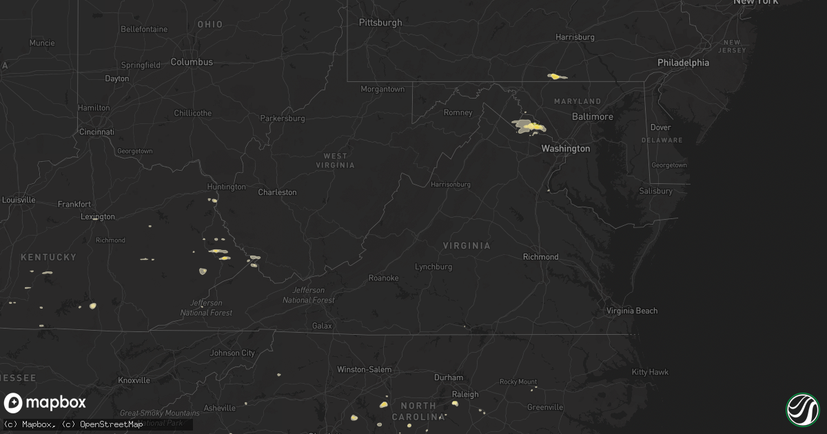
Hail Map in Virginia on September 2, 2014
Get this storm
September 2 map
$229
one time, instant access
Download today. No call, no setup
Keep the $229
Bought the map and want the full workflow? Apply the entire $229 to a subscription within 7 days. None of it is wasted.
Every map, not just this one
This buys you this map. Subscription and you get every map we run, in the markets you choose from a few cities to whole states to nationwide. Plus real-time alerts the moment a storm fires.
Contact data
Name, contact info, occupancy, even credit band for addresses in the footprint. You go from where it hit to who to call.
Become the source they trust
Unlimited branding weather history reports on demand. You already have the documented answer ready for the property owner, and you are the one who showed up with it.
Property data and RoofTrace estimates
Pull up any address you have got, its value and the exact code rules for that jurisdiction, straight from One Click Code. Then RoofTrace estimates the squares, pitch, and roof value, priced the way you price.
Storm reports in Virginia
Virginia
| Date | Description |
|---|---|
| 09/02/20144:40 PM CDT | 5 trees down along route 687 just north of falling springs. |
| 09/02/20142:35 PM CDT | 2 trees down on old waterford rd |
| 09/01/20148:55 PM CDT | Tree down on route 705. Time of occurrence based on radar. |
| 09/01/20148:48 PM CDT | Tree down across sinking creek road. Time of occurrence based on radar velocity signature. |
All States Impacted by Hail Map on September 2, 2014
Cities Impacted by Hail Map on September 2, 2014
- Olpe, KS
- Hartford, KS
- Nickerson, KS
- Hutchinson, KS
- Wharncliffe, WV
- Okemah, OK
- Holly Springs, NC
- Apex, NC
- Debord, KY
- Live Oak, FL
- Tampa, KS
- Gettysburg, PA
- Littlestown, PA
- Arlington, KS
- Partridge, KS
- Troy, NC
- Middle River, MN
- Mahnomen, MN
- Harpers Ferry, WV
- Millville, WV
- Portland, TN
- Burlington, KS
- Lebo, KS
- Lancaster, MN
- Ellsworth, KS
- Lorraine, KS
- Osawatomie, KS
- Parker, KS
- Marion, NC
- Old Fort, NC
- Dorrance, KS
- Wilson, KS
- Leesburg, VA
- Waynesboro, MS
- Laurel, MS
- Shubuta, MS
- Dickerson, MD
- Ramona, KS
- McMillan, MI
- Germfask, MI
- Berryton, KS
- Estill, SC
- Elgin, SC
- Columbia, SC
- Bunker Hill, KS
- Hanover, PA
- Hamilton, VA
- Paeonian Springs, VA
- Waterford, VA
- Rush, KY
- Herington, KS
- Gould City, MI
- Gulliver, MI
- High Springs, FL
- Strathcona, MN
- Grygla, MN
- Butler, MO
- Kershaw, SC
- Moran, KS
- Beech Island, SC
- Aiken, SC
- Camden, SC
- Lane, KS
- Sparks, OK
- Paden, OK
- Prague, OK
- Stroud, OK
- Depew, OK
- Chandler, OK
- Fuquay Varina, NC
- Monee, IL
- Asheboro, NC
- Dawson, MN
- Boyd, MN
- Clarkfield, MN
- Westphalia, KS
- Garnett, KS
- Oakland, KY
- Smiths Grove, KY
- Gordon, GA
- Jeffersonville, GA
- Sophia, NC
- Amarillo, TX
- Chatsworth, GA
- Burnside, KY
- Cheraw, SC
- Beallsville, MD
- Poolesville, MD
- Purcellville, VA
- Raeford, NC
- Blue Mound, KS
- Mapleton, KS
- Fulton, KS
- Redfield, KS
- Fort Scott, KS
- Geneseo, KS
- Du Bois, PA
- Troutville, PA
- Reynoldsville, PA
- Luthersburg, PA
- Sykesville, PA
- Punxsutawney, PA
- Mayo, FL
- Cameron, NC
- Delia, KS
- Topeka, KS
- Pikeville, KY
- Prestonsburg, KY
- Stanville, KY
- Jesup, GA
- Durham, KS
- Sterling, KS
- Rockwell, NC
- Mount Pleasant, NC
- Gold Hill, NC
- Concord, NC
- Haven, KS
- Charles Town, WV
- Round Hill, VA
- Lovettsville, VA
- Gallatin, TN
- Meeker, OK
- Mcloud, OK
- Bronston, KY
- Monticello, KY
- Rebecca, GA
- Broadway, NC
- Sanford, NC
- Ivel, KY
- Allen, KY
- Banner, KY
- Varney, KY
- Martin, KY
- Ripley, OK
- McEwen, TN
- Centerville, KS
- Mound City, KS
- Gunlock, KY
- Carthage, NC
- Hurley, VA
- Crandall, GA
- Fort Bragg, NC
- Guyton, GA
- Mount Juliet, TN
- Brandon, MS
- Kimper, KY
- Raccoon, KY
- Fayetteville, NC
- Booneville, KY
- Hinesville, GA
- Holyrood, KS
- Townsend, GA
- Springfield, TN
- Newton, KS
- Whitewater, KS
- Cedar Point, KS
- Americus, KS
- Allen, KS
- Lexington, KY
- Amherst, MA
- Belchertown, MA
- Lyons, KS
- Gatzke, MN
- Loranger, LA
- Braxton, MS
- Lake Bronson, MN
- Chunchula, AL
- Greensboro, GA
- Union Point, GA
- Sarasota, FL
- Glasgow, KY
- Oak Harbor, WA
- Coupeville, WA
- Raven, KY
- Dema, KY
- Topmost, KY
- Kite, KY
- Pippa Passes, KY
- Garner, KY
- Strandquist, MN
- O'Brien, FL
- Wellston, OK
- Carney, OK
- Tarboro, NC
- Pinetops, NC
- Stanwood, WA
- Hope, KS
- Lost Springs, KS
- Prichard, WV
- Catlettsburg, KY
- Louisa, KY
- Ashland City, TN
- Chapmansboro, TN
- Greensburg, KY
- Center, KY
- Carbondale, KS
- Cushing, OK
- Agra, OK
- Lake City, FL
- Branford, FL
- Kentwood, LA
- Stafford, VA
- Greeley, KS
- Burkesville, KY
- Sunflower, AL
- Madison, MN
- Karlstad, MN
- Greenbush, MN
- Rantoul, KS
- La Cygne, KS
- Fontana, KS
- Dallas, GA
- Denton, NC
- Uniontown, KS
- Thomasville, GA
- Twin Valley, MN
- Gary, MN
- Latta, SC
- Perry, KS
- Grantville, KS
- Morton, MS
- Seminole, FL
- Lindsborg, KS
- Marquette, KS
- Sycamore, GA
- Pitkin, LA
- Red Springs, NC
- Crete, IL
- Beecher, IL
- Ranson, WV
- Vincent, KY
- Beattyville, KY
- Bryceville, FL
- Kincaid, KS
- Bronson, KS
- Wray, GA
- Brooklet, GA
- Burlingame, KS
- Bluemont, VA
- Norman, OK
- Hope Mills, NC
- Frenchburg, KY
- Omar, WV
- Delbarton, WV
- Sarah Ann, WV
- Clinton, MO
- Chesterfield, SC
- Chiefland, FL
- Abilene, KS
- Garnett, SC
- Lenoir, NC
- Pleasant View, TN
- Ashburn, GA
- Tallahassee, FL
- Lugoff, SC
- Ludowici, GA
- Mooresboro, NC
- Macomb, OK
- Arlington, SD
- Buffalo Junction, VA
- Tecumseh, KS
- Maple Hill, KS
- Waverly, KS
- Pleasanton, KS
- Prescott, KS
- Mayetta, KS
- Harrisburg, PA
- Waverly, TN
- Matewan, WV
- Mohawk, WV
- Majestic, KY
- Stopover, KY
- Mendenhall, MS
- Ruffin, SC
- Brunson, SC
- Bethpage, TN
- Crockett, TX
- Mount Vernon, AL
- Emmett, KS
- Tillman, SC
- Clyo, GA
- Wallace, SC
- Fort Stewart, GA
- Chatom, AL
- Lancaster, SC
- Heath Springs, SC
- Appalachia, VA
- Silver Lake, KS
- Williamsburg, KS
- Pomona, KS
- Patrick, SC
- Luray, SC
- Warner Robins, GA
- Bonaire, GA
- Zirconia, NC
- Saluda, NC
- Flat Rock, NC
- Pilgrim, KY
- Round O, SC
- Cottageville, SC
- Paxico, KS
- Belvue, KS
- Rossville, KS
- Saint Marys, KS
- Callahan, FL
- Bowling Green, KY
- Celina, TN
- Fargo, GA
- Hoyt, KS
- Springfield, GA
- Grundy, VA
- Mcpherson, KS
- Ridgeway, SC
- Eagle Springs, NC
- Folkston, GA
- Cisco, GA
- Burns, KS
- Claflin, KS
- Engadine, MI
- Curtis, MI
- Smithfield, NC
- Galva, KS
- Little River, AL
- Ottawa, KS
- Princeton, KS
- Clayton, NC
- Kanopolis, KS
- Little River, KS
- Roseland, LA
- Pointblank, TX
- Rocky Face, GA
- Dalton, GA
- Statesboro, GA
- Augusta, GA
- Knoxville, MD
- Iola, KS
- Humboldt, KS
- Adrian, GA
- Almo, KY
- Dexter, KY
- Foster, MO
- Camano Island, WA
- Tennessee Ridge, TN
- Wakarusa, KS
- Indian Mound, TN
- East Point, KY
- Hagerhill, KY
- Elk Horn, KY
- Campbellsville, KY
- Alma, KS
- Pegram, TN
- Richmond, KS
- Charlotte, TN
- Harleyville, SC
- Manor, GA
- Cassatt, SC
- Bethune, SC
- Acworth, GA
- Kite, GA
- Panhandle, TX
- Anita, PA
- Rockton, PA
- Penfield, PA


