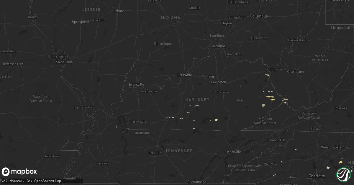
Hail Map in Kentucky on September 2, 2014
Get this storm
September 2 map
$229
one time, instant access
Download today. No call, no setup
Keep the $229
Bought the map and want the full workflow? Apply the entire $229 to a subscription within 7 days. None of it is wasted.
Every map, not just this one
This buys you this map. Subscription and you get every map we run, in the markets you choose from a few cities to whole states to nationwide. Plus real-time alerts the moment a storm fires.
Contact data
Name, contact info, occupancy, even credit band for addresses in the footprint. You go from where it hit to who to call.
Become the source they trust
Unlimited branding weather history reports on demand. You already have the documented answer ready for the property owner, and you are the one who showed up with it.
Property data and RoofTrace estimates
Pull up any address you have got, its value and the exact code rules for that jurisdiction, straight from One Click Code. Then RoofTrace estimates the squares, pitch, and roof value, priced the way you price.
Storm reports in Kentucky
Kentucky
| Date | Description |
|---|---|
| 09/02/20145:55 PM CDT | Four trees down on hwy 221. |
| 09/02/20145:52 PM CDT | Five trees down on hwy 66. |
| 09/02/20145:40 PM CDT | Tree down on rt. 899 between mile markers 7 and 11. |
| 09/02/20145:25 PM CDT | Tree down on hwy 52 w. |
| 09/02/20145:20 PM CDT | Tree across ky 979. |
| 09/02/20145:11 PM CDT | Tree down...partially blocking highway 511. |
| 09/02/20145:10 PM CDT | Tree across ky 122. |
| 09/02/20145:05 PM CDT | Power lines down near pizza hut. Report from facebook. |
| 09/02/20144:55 PM CDT | Tree across road on hwy 52 east on tunnel hill. |
| 09/02/20144:45 PM CDT | Two trees across road. |
| 09/02/20144:45 PM CDT | Tree across hwy 587 at farmers ridge. |
| 09/02/20144:45 PM CDT | Storm spotter reported roof and gutter damage to the vfw hall in whitley city on main street. |
| 09/02/20144:41 PM CDT | Tree blown across norfolk southern train track at train track marker 187. A train ran into the tree a short time later. No injuries. |
| 09/02/20144:37 PM CDT | Trees down across hwy 3630 and moore road. Delayed report...time estimated by radar. |
| 09/02/20144:35 PM CDT | Tree down across hwy 3630. Delayed report...time estimated by radar. |
| 09/02/20144:35 PM CDT | Several trees down along rush creek rd. Possible small downburst. |
| 09/02/20144:15 PM CDT | Two trees down. |
| 09/02/20144:10 PM CDT | Tree across hwy 52. |
| 09/02/20144:10 PM CDT | Tree across hwy 499. |
| 09/02/20144:00 PM CDT | Tree down on kentucky highway 2001. Time estimated from radar. |
| 09/02/20143:57 PM CDT | Tree across hwy 89. |
| 09/02/20143:05 PM CDT | Tree across road. |
| 09/02/20142:56 PM CDT | Tree down blocking fox hollow road. |
| 09/02/20142:55 PM CDT | Tree down on highway 11. Time estimated from radar. |
| 09/02/20142:50 PM CDT | Two trees down on ky 11 near the lee county line. |
| 09/02/20142:42 PM CDT | Tree across rt. 299. |
| 09/02/20142:30 PM CDT | Trailer blown over on harp road. |
All States Impacted by Hail Map on September 2, 2014
Cities Impacted by Hail Map on September 2, 2014
- Olpe, KS
- Hartford, KS
- Nickerson, KS
- Hutchinson, KS
- Wharncliffe, WV
- Okemah, OK
- Holly Springs, NC
- Apex, NC
- Debord, KY
- Live Oak, FL
- Tampa, KS
- Gettysburg, PA
- Littlestown, PA
- Arlington, KS
- Partridge, KS
- Troy, NC
- Middle River, MN
- Mahnomen, MN
- Harpers Ferry, WV
- Millville, WV
- Portland, TN
- Burlington, KS
- Lebo, KS
- Lancaster, MN
- Ellsworth, KS
- Lorraine, KS
- Osawatomie, KS
- Parker, KS
- Marion, NC
- Old Fort, NC
- Dorrance, KS
- Wilson, KS
- Leesburg, VA
- Waynesboro, MS
- Laurel, MS
- Shubuta, MS
- Dickerson, MD
- Ramona, KS
- McMillan, MI
- Germfask, MI
- Berryton, KS
- Estill, SC
- Elgin, SC
- Columbia, SC
- Bunker Hill, KS
- Hanover, PA
- Hamilton, VA
- Paeonian Springs, VA
- Waterford, VA
- Rush, KY
- Herington, KS
- Gould City, MI
- Gulliver, MI
- High Springs, FL
- Strathcona, MN
- Grygla, MN
- Butler, MO
- Kershaw, SC
- Moran, KS
- Beech Island, SC
- Aiken, SC
- Camden, SC
- Lane, KS
- Sparks, OK
- Paden, OK
- Prague, OK
- Stroud, OK
- Depew, OK
- Chandler, OK
- Fuquay Varina, NC
- Monee, IL
- Asheboro, NC
- Dawson, MN
- Boyd, MN
- Clarkfield, MN
- Westphalia, KS
- Garnett, KS
- Oakland, KY
- Smiths Grove, KY
- Gordon, GA
- Jeffersonville, GA
- Sophia, NC
- Amarillo, TX
- Chatsworth, GA
- Burnside, KY
- Cheraw, SC
- Beallsville, MD
- Poolesville, MD
- Purcellville, VA
- Raeford, NC
- Blue Mound, KS
- Mapleton, KS
- Fulton, KS
- Redfield, KS
- Fort Scott, KS
- Geneseo, KS
- Du Bois, PA
- Troutville, PA
- Reynoldsville, PA
- Luthersburg, PA
- Sykesville, PA
- Punxsutawney, PA
- Mayo, FL
- Cameron, NC
- Delia, KS
- Topeka, KS
- Pikeville, KY
- Prestonsburg, KY
- Stanville, KY
- Jesup, GA
- Durham, KS
- Sterling, KS
- Rockwell, NC
- Mount Pleasant, NC
- Gold Hill, NC
- Concord, NC
- Haven, KS
- Charles Town, WV
- Round Hill, VA
- Lovettsville, VA
- Gallatin, TN
- Meeker, OK
- Mcloud, OK
- Bronston, KY
- Monticello, KY
- Rebecca, GA
- Broadway, NC
- Sanford, NC
- Ivel, KY
- Allen, KY
- Banner, KY
- Varney, KY
- Martin, KY
- Ripley, OK
- McEwen, TN
- Centerville, KS
- Mound City, KS
- Gunlock, KY
- Carthage, NC
- Hurley, VA
- Crandall, GA
- Fort Bragg, NC
- Guyton, GA
- Mount Juliet, TN
- Brandon, MS
- Kimper, KY
- Raccoon, KY
- Fayetteville, NC
- Booneville, KY
- Hinesville, GA
- Holyrood, KS
- Townsend, GA
- Springfield, TN
- Newton, KS
- Whitewater, KS
- Cedar Point, KS
- Americus, KS
- Allen, KS
- Lexington, KY
- Amherst, MA
- Belchertown, MA
- Lyons, KS
- Gatzke, MN
- Loranger, LA
- Braxton, MS
- Lake Bronson, MN
- Chunchula, AL
- Greensboro, GA
- Union Point, GA
- Sarasota, FL
- Glasgow, KY
- Oak Harbor, WA
- Coupeville, WA
- Raven, KY
- Dema, KY
- Topmost, KY
- Kite, KY
- Pippa Passes, KY
- Garner, KY
- Strandquist, MN
- O'Brien, FL
- Wellston, OK
- Carney, OK
- Tarboro, NC
- Pinetops, NC
- Stanwood, WA
- Hope, KS
- Lost Springs, KS
- Prichard, WV
- Catlettsburg, KY
- Louisa, KY
- Ashland City, TN
- Chapmansboro, TN
- Greensburg, KY
- Center, KY
- Carbondale, KS
- Cushing, OK
- Agra, OK
- Lake City, FL
- Branford, FL
- Kentwood, LA
- Stafford, VA
- Greeley, KS
- Burkesville, KY
- Sunflower, AL
- Madison, MN
- Karlstad, MN
- Greenbush, MN
- Rantoul, KS
- La Cygne, KS
- Fontana, KS
- Dallas, GA
- Denton, NC
- Uniontown, KS
- Thomasville, GA
- Twin Valley, MN
- Gary, MN
- Latta, SC
- Perry, KS
- Grantville, KS
- Morton, MS
- Seminole, FL
- Lindsborg, KS
- Marquette, KS
- Sycamore, GA
- Pitkin, LA
- Red Springs, NC
- Crete, IL
- Beecher, IL
- Ranson, WV
- Vincent, KY
- Beattyville, KY
- Bryceville, FL
- Kincaid, KS
- Bronson, KS
- Wray, GA
- Brooklet, GA
- Burlingame, KS
- Bluemont, VA
- Norman, OK
- Hope Mills, NC
- Frenchburg, KY
- Omar, WV
- Delbarton, WV
- Sarah Ann, WV
- Clinton, MO
- Chesterfield, SC
- Chiefland, FL
- Abilene, KS
- Garnett, SC
- Lenoir, NC
- Pleasant View, TN
- Ashburn, GA
- Tallahassee, FL
- Lugoff, SC
- Ludowici, GA
- Mooresboro, NC
- Macomb, OK
- Arlington, SD
- Buffalo Junction, VA
- Tecumseh, KS
- Maple Hill, KS
- Waverly, KS
- Pleasanton, KS
- Prescott, KS
- Mayetta, KS
- Harrisburg, PA
- Waverly, TN
- Matewan, WV
- Mohawk, WV
- Majestic, KY
- Stopover, KY
- Mendenhall, MS
- Ruffin, SC
- Brunson, SC
- Bethpage, TN
- Crockett, TX
- Mount Vernon, AL
- Emmett, KS
- Tillman, SC
- Clyo, GA
- Wallace, SC
- Fort Stewart, GA
- Chatom, AL
- Lancaster, SC
- Heath Springs, SC
- Appalachia, VA
- Silver Lake, KS
- Williamsburg, KS
- Pomona, KS
- Patrick, SC
- Luray, SC
- Warner Robins, GA
- Bonaire, GA
- Zirconia, NC
- Saluda, NC
- Flat Rock, NC
- Pilgrim, KY
- Round O, SC
- Cottageville, SC
- Paxico, KS
- Belvue, KS
- Rossville, KS
- Saint Marys, KS
- Callahan, FL
- Bowling Green, KY
- Celina, TN
- Fargo, GA
- Hoyt, KS
- Springfield, GA
- Grundy, VA
- Mcpherson, KS
- Ridgeway, SC
- Eagle Springs, NC
- Folkston, GA
- Cisco, GA
- Burns, KS
- Claflin, KS
- Engadine, MI
- Curtis, MI
- Smithfield, NC
- Galva, KS
- Little River, AL
- Ottawa, KS
- Princeton, KS
- Clayton, NC
- Kanopolis, KS
- Little River, KS
- Roseland, LA
- Pointblank, TX
- Rocky Face, GA
- Dalton, GA
- Statesboro, GA
- Augusta, GA
- Knoxville, MD
- Iola, KS
- Humboldt, KS
- Adrian, GA
- Almo, KY
- Dexter, KY
- Foster, MO
- Camano Island, WA
- Tennessee Ridge, TN
- Wakarusa, KS
- Indian Mound, TN
- East Point, KY
- Hagerhill, KY
- Elk Horn, KY
- Campbellsville, KY
- Alma, KS
- Pegram, TN
- Richmond, KS
- Charlotte, TN
- Harleyville, SC
- Manor, GA
- Cassatt, SC
- Bethune, SC
- Acworth, GA
- Kite, GA
- Panhandle, TX
- Anita, PA
- Rockton, PA
- Penfield, PA


