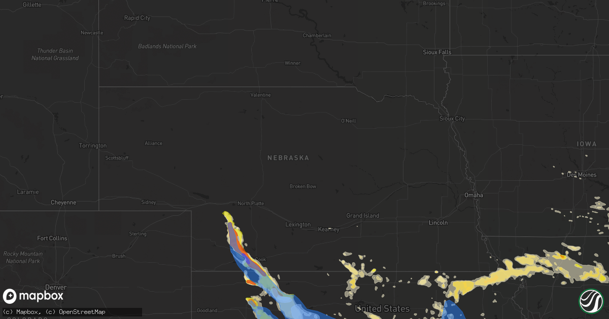
Hail Map in Nebraska on August 29, 2019
Get this storm
August 29 map
$229
one time, instant access
Download today. No call, no setup
Keep the $229
Bought the map and want the full workflow? Apply the entire $229 to a subscription within 7 days. None of it is wasted.
Every map, not just this one
This buys you this map. Subscription and you get every map we run, in the markets you choose from a few cities to whole states to nationwide. Plus real-time alerts the moment a storm fires.
Contact data
Name, contact info, occupancy, even credit band for addresses in the footprint. You go from where it hit to who to call.
Become the source they trust
Unlimited branding weather history reports on demand. You already have the documented answer ready for the property owner, and you are the one who showed up with it.
Property data and RoofTrace estimates
Pull up any address you have got, its value and the exact code rules for that jurisdiction, straight from One Click Code. Then RoofTrace estimates the squares, pitch, and roof value, priced the way you price.
Storm reports in Nebraska
Nebraska
| Date | Description |
|---|---|
| 08/29/20196:55 PM CDT | Delayed report via facebook with a picture. |
| 08/29/20196:45 PM CDT | Delayed report via facebook. Includes a picture of hail next to measuring tape. |
| 08/29/20196:45 PM CDT | Report via twitter with a picture of a large tree down. |
| 08/29/20196:32 PM CDT | A local report indicates 1.00 inch wind near 10 SSE CULBERTSON |
| 08/29/20196:30 PM CDT | A local report indicates 1.75 inch wind near CULBERTSON |
| 08/29/20196:25 PM CDT | A local report indicates 1.75 inch wind near CULBERTSON |
| 08/29/20196:24 PM CDT | Delayed report via twitter showing a picture of 2 inch hail. Time estimated based on radar. |
| 08/29/20196:24 PM CDT | A local report indicates 65 MPH wind near 3 WNW TRENTON |
| 08/29/20196:24 PM CDT | Report via twitter with a picture of an overturned pivot. Time estimated based on radar. |
| 08/29/20196:20 PM CDT | A local report indicates 1.25 inch wind near 5 SSE CULBERTSON |
| 08/29/20196:19 PM CDT | A local report indicates 72 MPH wind near 3 WSW CULBERTSON |
| 08/29/20196:15 PM CDT | Delayed report...road sign ripped out of the ground. Time estimated based on radar. |
| 08/29/20196:11 PM CDT | A local report indicates 1.50 inch wind near 5 N CULBERTSON |
| 08/29/20196:10 PM CDT | Delayed report via facebook of a roof ripped off a barn near trenton. Time estimated based on radar. |
| 08/29/20196:10 PM CDT | Power lines down 8 miles south of palisade. Report via twitter with a picture. |
| 08/29/20196:03 PM CDT | Tree damage and power lines down at hwy 6 and hwy 25. |
| 08/29/20196:00 PM CDT | Report included a picture of golf-ball size hail. |
| 08/29/20195:55 PM CDT | Wind driven hail damaged siding on house. Relayed via social media. Time estimated from radar |
| 08/29/20195:55 PM CDT | Report of funnel cloud/possible tornado and rotation with the storm 1 mile south and 2 miles west of the hayes/hitchcock county line near old hwy 17. |
| 08/29/20195:50 PM CDT | Storm survey by nws north platte confirms straight line wind damage to a farm southwest of palisade. A barn was completely destroyed... As well as trees snapped... Tree |
| 08/29/20195:46 PM CDT | A local report indicates a tornado near 6 ENE HAMLET |
| 08/29/20195:45 PM CDT | Ef-0 tornado confirmed via radar and video. |
| 08/29/20195:40 PM CDT | A local report indicates a tornado near 7 SSW HAYES CENTER |
| 08/29/20195:37 PM CDT | Brief rope tornado |
| 08/29/20195:30 PM CDT | Ef-0 tornado confirmed via storm survey. |
| 08/29/20195:25 PM CDT | Ne-meso030 |
| 08/29/20195:25 PM CDT | Corrects previous tornado report from 8 wnw hayes center. Ef-1 tornado confirmed via storm survey. |
| 08/29/20195:25 PM CDT | A local report indicates 1.75 inch wind near 2 N HAYES CENTER |
| 08/29/20194:52 PM CDT | A local report indicates 1.25 inch wind near 12 S WALLACE |
| 08/29/20194:52 PM CDT | A local report indicates 60 MPH wind near 12 S WALLACE |
| 08/29/20194:48 PM CDT | A local report indicates 1.00 inch wind near 8 S WALLACE |
| 08/29/20194:43 PM CDT | A local report indicates 1.50 inch wind near 10 S WALLACE |
| 08/29/20194:57 AM CDT | At 956 PM CDT, severe thunderstorms were located along a line extending from near Highland to near Clarksdale, moving south at 15 mph. HAZARD...60 mph wind gusts and quarter size hail. SOURCE...Radar indicated. IMPACT...Hail damage to vehicles is expected. Expect wind damage to roofs, siding, and trees. Locations impacted include... St. Joseph, Savannah, Wathena, Elwood, Highland, Troy, Country Club Villa, Country Club, Oregon, Union Star, Amazonia, Forest City, White Cloud, Denton, Easton, Cosby, Severance, Leona, St. Joseph Airport and Bendena.This includes the following highways... Interstate 29 between mile markers 42 and 70. Interstate 229 between mile markers 0 and 14. |
| 08/29/20194:28 AM CDT | At 927 PM CDT, severe thunderstorms were located along a line extending from White Cloud to near Morrill, moving east to southeast at 35 mph. HAZARD...60 mph wind gusts and quarter size hail. SOURCE...Radar indicated. IMPACT...Hail damage to vehicles is expected. Expect wind damage to roofs, siding, and trees. Locations impacted include... Hiawatha, Robinson, Morrill, Reserve and Hamlin. |
| 08/29/20193:42 AM CDT | At 842 PM CDT, a severe thunderstorm was located 8 miles south of Red Cloud, or 39 miles northwest of Beloit, moving southeast at 20 mph. HAZARD...60 mph wind gusts and quarter size hail. SOURCE...Radar indicated. IMPACT...Hail damage to vehicles is expected. Expect wind damage to roofs, siding, and trees. Locations impacted include... Red Cloud, Mankato, Guide Rock, Lebanon, Burr Oak, Esbon, Cowles, Webber, Bostwick, Inavale and Lovewell State Park. |
| 08/29/20191:16 AM CDT | At 616 PM CDT, a severe thunderstorm was located 10 miles south of Culbertson, or 11 miles southeast of Trenton, moving southeast at 35 mph. HAZARD...Two inch hail and 70 mph wind gusts. SOURCE...Radar indicated. IMPACT...People and animals outdoors will be injured. Expect hail damage to roofs, siding, windows, and vehicles. Expect considerable tree damage. Wind damage is also likely to mobile homes, roofs, and outbuildings. Locations impacted include... McCook, Oberlin, Atwood, Trenton, Culbertson, Indianola and Bartley. |
| 08/29/201912:27 AM CDT | At 527 PM CDT, severe thunderstorms were located along a line extending from 7 miles northeast of Hayes Center to 8 miles northeast of Wauneta, moving south at 20 mph. HAZARD...Golf ball size hail and 70 mph wind gusts. SOURCE...Radar indicated. IMPACT...People and animals outdoors will be injured. Expect hail damage to roofs, siding, windows, and vehicles. Expect considerable tree damage. Wind damage is also likely to mobile homes, roofs, and outbuildings. Locations impacted include... Hayes Center, Hamlet, Marengo and Hayes Center State Wildlife Management Area. |
| 08/28/201911:43 PM CDT | At 442 PM CDT/342 PM MDT/, a severe thunderstorm was located near Wallace, or 20 miles north of Hayes Center, moving southeast at 20 mph. HAZARD...Ping pong ball size hail and 60 mph wind gusts. SOURCE...Radar indicated. IMPACT...People and animals outdoors will be injured. Expect hail damage to roofs, siding, windows, and vehicles. Expect wind damage to roofs, siding, and trees. Locations impacted include... Hayes Center, Dickens, Marengo and Hayes Center State Wildlife Management Area. |
| 08/28/201911:10 PM CDT | At 410 PM CDT/310 PM MDT/, a severe thunderstorm was located 9 miles northeast of Elsie, or 24 miles east of Grant, moving southeast at 10 mph. HAZARD...Ping pong ball size hail and 60 mph wind gusts. SOURCE...Radar indicated. IMPACT...People and animals outdoors will be injured. Expect hail damage to roofs, siding, windows, and vehicles. Expect wind damage to roofs, siding, and trees. This severe thunderstorm will be near... Wallace around 500 PM CDT.Other locations impacted by this severe thunderstorm includeGrainton. |
| 08/28/20199:15 PM CDT | Not a lot of hail... But a few stones were quarter size. |
All States Impacted by Hail Map on August 29, 2019
Cities Impacted by Hail Map on August 29, 2019
- Haslett, MI
- Williamston, MI
- Hoisington, KS
- Claflin, KS
- Stover, MO
- Gravois Mills, MO
- Edwards, MO
- Climax Springs, MO
- Preston, MO
- Macks Creek, MO
- Arkansas City, KS
- Geuda Springs, KS
- Clinton, OK
- Aspermont, TX
- Paducah, TX
- Old Glory, TX
- Weldon, IA
- Wright, KS
- Greensburg, KS
- Haviland, KS
- Wilmore, KS
- Offerle, KS
- Spearville, KS
- Bucklin, KS
- Mullinville, KS
- Hanston, KS
- Jetmore, KS
- Kinsley, KS
- Protection, KS
- Minneola, KS
- Dalhart, TX
- Nara Visa, NM
- Hayes Center, NE
- Wallace, NE
- Chillicothe, MO
- Chula, MO
- Braman, OK
- Newkirk, OK
- Perry, OK
- Billings, OK
- Jerome, AZ
- Crossroads, NM
- Tatum, NM
- Pawnee, OK
- Marysville, KS
- Blue Rapids, KS
- Jal, NM
- Cedar Springs, MI
- Rockford, MI
- Coffey, MO
- Conception, MO
- Frankfort, KS
- Maysville, MO
- Laredo, MO
- Bolckow, MO
- Seneca, KS
- Humphreys, MO
- Mound City, MO
- Graham, MO
- Wheeling, MO
- Purdin, MO
- Maitland, MO
- Browning, MO
- Weatherby, MO
- Rea, MO
- Sabetha, KS
- Jamesport, MO
- Savannah, MO
- Gallatin, MO
- White Cloud, KS
- Trenton, MO
- Vermillion, KS
- Linneus, MO
- Craig, MO
- Corning, KS
- New Hampton, MO
- Laclede, MO
- Skidmore, MO
- Maryville, MO
- Milan, MO
- Clyde, MO
- Stanberry, MO
- Oregon, MO
- Robinson, KS
- Onaga, KS
- Fairview, KS
- Westmoreland, KS
- Brookfield, MO
- Galt, MO
- Gentry, MO
- Axtell, KS
- Bethany, MO
- Oneida, KS
- Conception Junction, MO
- Pattonsburg, MO
- Highland, KS
- Darlington, MO
- Barnard, MO
- Meadville, MO
- Union Star, MO
- Guilford, MO
- Goff, KS
- Fillmore, MO
- Morrill, KS
- Beattie, KS
- Bucklin, MO
- Amazonia, MO
- Baileyville, KS
- Rulo, NE
- Forest City, MO
- Albany, MO
- Powhattan, KS
- Hiawatha, KS
- Helena, MO
- Martinsville, MO
- McFall, MO
- Centralia, KS
- Ridgeway, MO
- Rosendale, MO
- Lock Springs, MO
- Jameson, MO
- King City, MO
- Gilman City, MO
- Ensign, KS
- Copeland, KS
- Montezuma, KS
- Plains, KS
- Palisade, NE
- Selden, KS
- Minneapolis, KS
- Beloit, KS
- Barnard, KS
- Afton, IA
- Grand River, IA
- Great Bend, KS
- Rock, KS
- Burden, KS
- Chariton, IA
- Keyes, OK
- Moulton, IA
- Oberlin, KS
- Herndon, KS
- Plainville, KS
- Ellis, KS
- Sedona, AZ
- Rochester, TX
- O'Brien, TX
- Centerville, IA
- Downing, MO
- Exline, IA
- Lancaster, MO
- Udell, IA
- Drakesville, IA
- Memphis, MO
- Pulaski, IA
- Bloomfield, IA
- Albia, IA
- Coatsville, MO
- Unionville, IA
- Moravia, IA
- Oakwood, OK
- Danbury, NE
- Lenora, KS
- Clayton, KS
- Hill City, KS
- Hoxie, KS
- Penokee, KS
- Bogue, KS
- Jennings, KS
- Dickens, NE
- Dresden, KS
- Morland, KS
- Wauneta, NE
- Trenton, NE
- Norcatur, KS
- McCook, NE
- Palco, KS
- Ludell, KS
- Elsie, NE
- Norton, KS
- Culbertson, NE
- Burr Oak, KS
- Riverton, NE
- Falls City, NE
- Mooreland, OK
- Woodward, OK
- Washington, KS
- Winfield, KS
- Dexter, KS
- Guide Rock, NE
- Blue Hill, NE
- Topeka, KS
- Shelby, MI
- New Era, MI
- Middleville, MI
- Woodland, MI
- Clarksville, MI
- Hastings, MI
- Bellevue, MI
- Freeport, MI
- Vermontville, MI
- Charlotte, MI
- Alto, MI
- Lake Odessa, MI
- Caledonia, MI
- Nashville, MI
- Grand Rapids, MI
- Saranac, MI
- Lowell, MI
- Fair Grove, MO
- Springfield, MO
- Vernon, TX
- Portis, KS
- Downs, KS
- Melrose, IA
- Wynona, OK
- Lorraine, KS
- Geneseo, KS
- Kiowa, KS
- Fay, OK
- Canton, OK
- Longdale, OK
- Taloga, OK
- Seiling, OK
- Flagstaff, AZ
- Hamilton, KS
- Russell, KS
- Bunker Hill, KS
- Dorrance, KS
- Victoria, KS
- Gorham, KS
- Thomas, OK
- Payson, AZ
- Leoti, KS
- Tribune, KS
- Dodge City, KS
- Cimarron, KS
- Collyer, KS
- Wakeeney, KS
- Quinter, KS
- Kent City, MI
- Casnovia, MI
- Alma, KS
- Pond Creek, OK
- Kremlin, OK
- Mayer, AZ
- Colby, KS
- Rexford, KS
- Henderson, MI
- Elsie, MI
- Tunas, MO
- Hunter, OK
- Tonkawa, OK
- Coral, MI
- Pierson, MI
- Trufant, MI
- Randolph, KS
- Osage City, KS
- Burlingame, KS
- Scranton, KS
- Lindsborg, KS
- Roach, MO
- Camdenton, MO
- Junction City, KS
- Fort Riley, KS
- Geary, OK
- Weatherford, OK
- Seminole, OK
- Superior, NE
- Mankato, KS
- Ogallah, KS
- Hays, KS
- Sand Lake, MI
- Bailey, MI
- Sparta, MI
- Muskegon, MI
- Fremont, MI
- Holton, MI
- Grant, MI
- Ravenna, MI
- Gowen, MI
- Newaygo, MI
- Twin Lake, MI
- Fenwick, MI
- Greenville, MI
- Whitehall, MI
- Montague, MI
- Nelson, NE
- Fairfax, OK
- Burbank, OK
- Liebenthal, KS
- La Crosse, KS
- Bison, KS
- McCracken, KS
- Choctaw, OK
- Thompson, MO
- Centralia, MO
- Salisbury, MO
- Clifton Hill, MO
- Summerfield, KS
- Orleans, MI
- Kingdom City, MO
- Fulton, MO
- Corn, OK
- Waldo, KS
- Luray, KS
- Delphos, KS
- Longford, KS
- Clay Center, KS
- Chase, KS
- Partridge, KS
- Sterling, KS
- Little River, KS
- Abbyville, KS
- Lyons, KS
- Windom, KS
- Nickerson, KS
- Hutchinson, KS
- Inman, KS
- Queen City, MO
- Kewaskum, WI
- Random Lake, WI
- Oostburg, WI
- Cedar Grove, WI
- Adell, WI
- Cascade, WI
- Campbellsport, WI
- Waldo, WI
- New Richmond, WI
- Deer Park, WI
- Manhattan, KS
- Saint George, KS
- Belle Plaine, KS
- Wellington, KS
- Gotebo, OK
- Mountain View, OK
- South Haven, KS
- Boonville, MO
- Mayfield, KS
- Tecumseh, KS
- Coldwater, KS
- Salina, KS
- New Cambria, KS
- Orlando, OK
- Yale, OK
- Inavale, NE
- Red Cloud, NE
- Bartlesville, OK
- Blackwell, OK
- Lebanon, KS
- Gaylord, KS
- Esbon, KS
- New River, AZ
- Quanah, TX
- Sheboygan, WI
- Ogden, KS
- Riley, KS
- Holcombe, WI
- Cornell, WI
- Saint Johns, MI
- Princeton, MO
- Cainsville, MO
- Marion, WI
- Sawyer, KS
- Kiel, WI
- New Holstein, WI
- Cleveland, WI
- Elkhart Lake, WI
- Newton, WI
- Paxico, KS
- McFarland, KS
- Emporia, KS
- Cambridge, IA
- Goddard, KS
- Garden Plain, KS
- Kingman, KS
- Murdock, KS
- Pretty Prairie, KS
- Cheney, KS
- Ingalls, KS
- Harveyville, KS
- Eskridge, KS
- Donnellson, IA
- Grantville, KS
- El Dorado, KS
- Cambridge, KS
- Lakin, KS
- Cherokee, OK
- Loveland, OK
- Walters, OK
- Chattanooga, OK
- Custer City, OK
- Young, AZ
- Marland, OK
- Ponca City, OK
- Saugatuck, MI
- Longton, KS
- Elk City, KS
- Alva, OK
- Norwich, KS
- Belleville, KS
- Scandia, KS
- Holden, MO
- Arnett, OK
- Syracuse, KS
- Ovid, MI
- Laingsburg, MI
- Meeker, OK
- Wellston, OK
- Sun City, KS
- Alden, KS
- Cuba, KS
- Abilene, KS
- Cheyenne, OK
- Knox City, TX
- Leonardville, KS
- Olsburg, KS
- Dwight, KS
- Alta Vista, KS
- Chester, OK
- Marceline, MO
- New Cambria, MO
- Brookville, KS
- Lewis, KS
- Goodwell, OK
- Kendall, KS
- Greentop, MO
- Schoenchen, KS
- Atwood, KS
- Park, KS
- Fowler, MI
- Muir, MI
- Ionia, MI
- Conklin, MI
- Pewamo, MI
- Morrice, MI
- Owosso, MI
- Fort Supply, OK
- Clark, MO
- Moberly, MO
- Sturgeon, MO
- Cairo, MO
- Madison, MO
- Curtiss, WI
- Pulaski, WI
- Seymour, WI
- Mannford, OK
- Wilson, KS
- Coffeyville, KS
- S Coffeyville, OK
- Barnsdall, OK
- Urbandale, IA
- Courtland, KS
- Howell, MI
- Formoso, KS
- Jewell, KS
- Rule, TX
- Black Creek, WI
- Shiocton, WI
- Council Grove, KS
- Colony, OK
- Cordell, OK
- Stillwater, OK
- Cache, OK
- Macon, MO
- Excello, MO
- Bevier, MO
- Strong City, KS
- Americus, KS
- Dickens, TX
- Coats, KS
- Gilman, WI
- Ellinwood, KS
- Hudson, KS
- Atlanta, KS
- Parsons, KS
- Shidler, OK
- Dewey, AZ
- Raymond, KS
- Lincoln, MO
- Cole Camp, MO
- Warsaw, MO
- Holcomb, KS
- Garden City, KS
- Nash, OK
- Chippewa Falls, WI
- Hoyt, KS
- Mayetta, KS
- Lake City, KS
- Perry, IA
- Linden, IA
- Marshall, MO
- Hardy, NE
- South Hutchinson, KS
- Spearman, TX
- Tigerton, WI
- Osage, OK
- Sedan, KS
- Glen Elder, KS
- Tipton, KS
- Eureka, KS
- Erie, KS
- Stark, KS
- Walnut, KS
- Ralston, OK
- Odell, NE
- Bremen, KS
- Belvue, KS
- Elk Falls, KS
- Holland, MI
- Douglas, MI
- Lovilia, IA
- Russell, IA
- Williamson, IA
- Morrison, OK
- Milton, KS
- Viola, KS
- Conway Springs, KS
- Sunrise Beach, MO
- Belmont, MI
- Comstock Park, MI
- Unionville, MO
- Wakefield, KS
- Nelson, MO
- Slater, MO
- Lincoln, KS
- Glencoe, OK
- Wallace, KS
- Virgil, KS
- Madison, KS
- Niotaze, KS
- Bushton, KS
- Holyrood, KS
- Paradise, KS
- Ellsworth, KS
- Sylvan Grove, KS
- Pfeifer, KS
- Laverne, OK
- Campbell, NE
- Hurdland, MO
- Edina, MO
- Baring, MO
- Melvern, KS
- Ochelata, OK
- Allegan, MI
- Livonia, MO
- Milton, IA
- Blakesburg, IA
- Mystic, IA
- Glenwood, MO
- Cantril, IA
- Cincinnati, IA
- Otis, KS
- Armstrong, MO
- Clearwater, KS
- Hartford, KS
- Olpe, KS
- Chandler, OK
- Humeston, IA
- Woodburn, IA
- Haddam, KS
- Bristow, OK
- Kearney, NE
- Hamilton, MO
- Grenola, KS
- Red Rock, OK
- Hollenberg, KS
- Hanover, KS
- Osborne, KS
- Corydon, IA
- Pawhuska, OK
- Cleo Springs, OK
- Nunica, MI
- Coopersville, MI
- Cushing, OK
- Douglass, KS
- Webber, KS
- Nauvoo, IL
- Niota, IL
- Fort Madison, IA
- Natoma, KS
- Winona, KS
- Belgium, WI
- Sheboygan Falls, WI
- Plymouth, WI
- Cedar Vale, KS
- Kanab, UT
- Damar, KS
- Buffalo, OK
- Crowell, TX
- Wamego, KS
- Burlington, OK
- Smith Center, KS
- Nowata, OK
- Depew, OK
- Maramec, OK
- Cleveland, OK
- Pratt, KS
- Auxvasse, MO
- Hallsville, MO
- Columbia, MO
- Savonburg, KS
- Elsmore, KS
- Melcher Dallas, IA
- Lacona, IA
- Knoxville, IA
- Admire, KS
- Morrowville, KS
- Greenleaf, KS
- Barnes, KS
- Beverly, KS
- Elmer, MO
- Atlanta, MO
- Okemah, OK
- Fruitport, MI
- Belding, MI
- Ada, MI
- Howard City, MI
- Hubbardston, MI
- Udall, KS
- Mulvane, KS
- Peck, KS
- Harris, MO
- Thayer, IA
- Pep, NM
- Farmington, IA
- Effingham, KS
- Muscotah, KS
- Holton, KS
- Munday, TX
- Fall Creek, WI
- Augusta, WI
- Home, KS
- Oketo, KS
- Haven, KS
- Olmitz, KS
- Lyons, MI
- Osceola, IA
- Seymour, TX
- Derby, IA
- Santa Rosa, TX
- Sharon, OK
- Shawnee, OK
- Kensington, KS
- Eldridge, MO
- Hamilton, MI
- Fennville, MI
- Higbee, MO
- Keytesville, MO
- Freedom, OK
- Hardesty, OK
- Davidson, OK
- Vinita, OK
- West Des Moines, IA
- Mount Hope, KS
- Andale, KS
- Fayette, MO
- Sharon Springs, KS
- Peru, KS
- Fall River, KS
- Ripley, OK
- Prairie Home, MO
- Carrier, OK
- Enid, OK
- Horton, KS
- Bunceton, MO
- Allen, KS
- Canadian, TX
- Clintonville, WI
- Bear Creek, WI
- Eagleville, MO
- Tescott, KS
- Bennington, KS
- Howard, KS
- Fowlerville, MI
- Perry, MI
- Byron, MI
- Helena, OK
- Jet, OK
- Goltry, OK
- Delaware, OK
- Welch, OK
- Lenapah, OK
- White City, KS
- Milford, KS
- Chapman, KS
- Promise City, IA
- Plano, IA
- Seymour, IA
- Linn Creek, MO
- Chillicothe, TX
- Lucas, KS
- Lamont, OK
- Argonia, KS
- Milan, KS
- Oxford, KS
- Nekoma, KS
- Alexander, KS
- Rush Center, KS
- Fairview, OK
- Sapulpa, OK
- Faxon, OK
- Albert, KS
- Ashley, MI
- Bannister, MI
- Cross Timbers, MO
- Arapaho, OK
- Saint Joseph, MO
- Hardtner, KS
- Tulsa, OK
- Doniphan, NE
- Escalante, UT
- Stroud, OK
- Clive, IA
- Waukee, IA
- Lawton, OK
- Sedan, NM
- Castle, OK
- Crawford, OK
- Lovington, NM
- Bladen, NE
- Ashland, KS
- Ramona, OK
- Van Wert, IA
- Allerton, IA
- Benjamin, TX
- Electra, TX
- Ford, KS
- Fowler, KS
- Des Moines, IA
- Maud, OK
- Adel, IA
- Abbotsford, WI
- Colby, WI
- Catharine, KS
- Jamestown, KS
- Jacksonville, MO
- Callao, MO
- Stratton, NE
- Stockton, KS
- Goessel, KS
- Colwich, KS
- Derby, KS
- Andover, KS
- Walker, KS
- Assaria, KS
- Gypsum, KS
- Haysville, KS
- Marion, KS
- Towanda, KS
- Peabody, KS
- Maize, KS
- Whitewater, KS
- Hillsboro, KS
- Burrton, KS
- Halstead, KS
- Falun, KS
- Augusta, KS
- Valley Center, KS
- Burns, KS
- Kanopolis, KS
- Moundridge, KS
- North Newton, KS
- Walton, KS
- Marquette, KS
- Greenwich, KS
- Canton, KS
- Tampa, KS
- Solomon, KS
- Lost Springs, KS
- Hope, KS
- Wichita, KS
- Kechi, KS
- Potwin, KS
- Grainfield, KS
- Elbing, KS
- Ramona, KS
- Florence, KS
- Galva, KS
- Benton, KS
- Rose Hill, KS
- Mcconnell Afb, KS
- Lincolnville, KS
- Lehigh, KS
- Newton, KS
- Bentley, KS
- Buhler, KS
- Sedgwick, KS
- Roxbury, KS
- Hesston, KS
- Durham, KS
- Mcpherson, KS
- Cherryvale, KS
- Dennis, KS
- Tyro, KS
- Benedict, KS
- Westphalia, KS
- Neosho Rapids, KS
- Humboldt, KS
- Neosho Falls, KS
- Chanute, KS
- Moline, KS
- Piqua, KS
- Auburn, KS
- Yates Center, KS
- Garnett, KS
- Buffalo, KS
- Neodesha, KS
- Burlington, KS
- Galesburg, KS
- Cottonwood Falls, KS
- Saint Marys, KS
- Liberty, KS
- Maple Hill, KS
- Le Roy, KS
- Waverly, KS
- Lyndon, KS
- Lebo, KS
- Dearing, KS
- Gridley, KS
- Altoona, KS
- Iola, KS
- Caney, KS
- Reading, KS
- Fredonia, KS
- Havana, KS
- Toronto, KS
- Independence, KS
- Neal, KS
- Mound Valley, KS
- Severy, KS
- Thayer, KS
- Matfield Green, KS
- Kaw City, OK
- Maple City, KS
- Sheridan, MI


