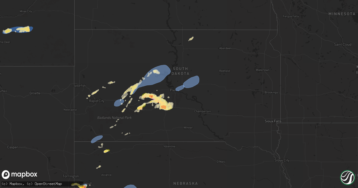
Hail Map in South Dakota on August 21, 2024
Get this storm
August 21 map
$229
one time, instant access
Download today. No call, no setup
Keep the $229
Bought the map and want the full workflow? Apply the entire $229 to a subscription within 7 days. None of it is wasted.
Every map, not just this one
This buys you this map. Subscription and you get every map we run, in the markets you choose from a few cities to whole states to nationwide. Plus real-time alerts the moment a storm fires.
Contact data
Name, contact info, occupancy, even credit band for addresses in the footprint. You go from where it hit to who to call.
Become the source they trust
Unlimited branding weather history reports on demand. You already have the documented answer ready for the property owner, and you are the one who showed up with it.
Property data and RoofTrace estimates
Pull up any address you have got, its value and the exact code rules for that jurisdiction, straight from One Click Code. Then RoofTrace estimates the squares, pitch, and roof value, priced the way you price.
Storm reports in South Dakota
South Dakota
| Date | Description |
|---|---|
| 08/21/20246:30 PM CDT | A local report indicates 62 MPH wind near 11 SSW Oelrichs |
| 08/20/202410:20 PM CDT | Power outage from event time until 4 am the following morning. |
| 08/20/202410:14 PM CDT | Asos station kpir pierre muni ap. |
| 08/20/202410:10 PM CDT | A local report indicates 1.50 inch wind near 5 SE Capa |
| 08/20/202410:00 PM CDT | Mesonet station 168 foster bay |
| 08/20/20249:55 PM CDT | A local report indicates 60 MPH wind near 13 NE Kirley |
| 08/20/20249:54 PM CDT | Mesonet station 168 foster bay |
| 08/20/20249:40 PM CDT | Mesonet station 19 harrold |
| 08/20/20249:10 PM CDT | A local report indicates 60 MPH wind near 6 W Milesville |
| 08/20/20249:00 PM CDT | Picture of 1 inch hail sent via google voice. |
| 08/20/20249:00 PM CDT | Golf ball to tennis ball size hail. |
| 08/20/20248:24 PM CDT | A local report indicates 63 MPH wind near 3 NW Wasta |
| 08/20/20248:00 PM CDT | Marble to ping pong ball sized hail reported to have fallen. |
| 08/20/20247:50 PM CDT | A local report indicates 60 MPH wind near Porcupine |
| 08/20/20247:43 PM CDT | A local report indicates 2.00 inch wind near 8 ESE Ottumwa |
| 08/20/20247:01 PM CDT | A local report indicates 60 MPH wind near 13 W Oglala |
| 08/20/20247:00 PM CDT | A local report indicates 1.00 inch wind near 1 NNW Nemo |
All States Impacted by Hail Map on August 21, 2024
Cities Impacted by Hail Map on August 21, 2024
- Prescott, AZ
- Chino Valley, AZ
- Tucson, AZ
- Pinetop, AZ
- Paulden, AZ
- Chadron, NE
- Saguache, CO
- Lakeside, AZ
- Show Low, AZ
- Prescott Valley, AZ
- Hay Springs, NE
- Elfrida, AZ
- Bisbee, AZ
- Ash Fork, AZ
- Willcox, AZ
- Heber, AZ
- Valentine, AZ
- Kingman, AZ
- Hackberry, AZ
- Tombstone, AZ
- Hemingford, NE
- Pearce, AZ
- Kadoka, SD
- Monte Vista, CO
- Williams, AZ
- Cochise, AZ
- Yoder, WY
- Opheim, MT
- Torrington, WY
- Lyman, NE
- Richland, MT
- Alamosa, CO
- Peerless, MT
- Benson, AZ
- Carter, MT
- Morrill, NE
- Gering, NE
- Philip, SD
- Loring, MT
- Floweree, MT
- Midland, SD
- Harrisburg, NE
- Scobey, MT
- Whitewater, MT
- Fort Benton, MT
- Albin, WY
- Pine Bluffs, WY
- Loma, MT
- Scottsbluff, NE
- Whitney, NE
- Edgemont, SD
- Oelrichs, SD
- Piedmont, SD
- Deadwood, SD
- Nemo, SD
- Sturgis, SD
- Okaton, SD
- Coffee Creek, MT
- Geraldine, MT
- Mohave Valley, AZ
- Needles, CA
- Topock, AZ
- Fort Pierre, SD
- Kimball, NE
- Minatare, NE
- Cheyenne, WY
- Burns, WY
- Pine Ridge, SD
- Hillsdale, WY
- Dix, NE
- Big Sandy, MT
- Kyle, SD
- Hayes, SD
- Fort Peck, MT
- Nashua, MT
- Jordan, MT
- Frazer, MT
- Union Center, SD
- Bayard, NE
- Potter, NE
- Box Elder, SD
- Carpenter, WY
- Dalton, NE
- Forsyth, MT
- Colstrip, MT
- Circle, MT
- Vida, MT
- Peridot, AZ
- Hilger, MT
- New Underwood, SD
- Bridgeport, NE
- Scenic, SD
- Wall, SD
- Enning, SD
- Lloyd, MT
- Batesland, SD
- Wounded Knee, SD
- Porcupine, SD
- Richey, MT
- Wasta, SD
- Owanka, SD
- Quinn, SD
- Martin, SD
- Bushnell, NE
- Broadwater, NE
- Volborg, MT
- New Raymer, CO
- Grover, CO
- Murdo, SD
- Allen, SD
- Milesville, SD
- Fallon, MT
- Glendive, MT
- Draper, SD
- Sidney, NE
- Stoneham, CO
- Padroni, CO
- Belvidere, SD
- Lisco, NE
- Cherry Creek, SD
- Cortez, CO
- Towaoc, CO
- Farmington, NM
- Kirtland, NM
- Bloomfield, NM
- Aztec, NM
- Flora Vista, NM
- Gurley, NE
- Peetz, CO
- Dupree, SD
- Eagle Butte, SD
- Iliff, CO
- Lodgepole, NE
- Oshkosh, NE
- Lewellen, NE
- Pierre, SD
- Blunt, SD
- Haxtun, CO
- Akron, CO
- Otis, CO
- Chappell, NE
- Crook, CO
- Holabird, SD
- Harrold, SD
- Onida, SD
- Highmore, SD
- Wolf Point, MT
- Poplar, MT
- Brockton, MT
- Froid, MT
- Culbertson, MT
- Fairview, MT
- Sedgwick, CO
- Sterling, CO
- Fleming, CO
- Big Springs, NE
- Cope, CO
- Anton, CO
- Java, SD
- Ashby, NE
- Arthur, NE
- Eureka, SD
- Mound City, SD
- Venango, NE
- Holyoke, CO
- Crosby, ND
- Bloomfield, MT
- Tioga, ND
- Max, ND
- Amherst, CO
- Minot, ND
- Sawyer, ND
- Hinsdale, MT
- Columbus, ND
- Brule, NE
- Ogallala, NE
- Grant, NE
- Paxton, NE
- Madrid, NE
- Elsie, NE
- Wallace, NE
- Watford City, ND
- Lignite, ND
- Portal, ND
- Velva, ND
- Bowbells, ND
- Flaxton, ND
- New Town, ND
- Steele, ND
- Norwich, ND
- Voltaire, ND
- Tuttle, ND
- Granville, ND
- Robinson, ND
- Sherwood, ND
- Karlsruhe, ND
- Lansford, ND
- Balfour, ND
- Dickens, NE
- Anamoose, ND
- Mohall, ND
- Maxbass, ND
- Pettibone, ND
- Tappen, ND
- Dawson, ND
- New Salem, ND
- Drake, ND
- Culbertson, NE
- Trenton, NE
- Rugby, ND
- Washburn, ND
- Mcclusky, ND
- Harvey, ND
- Goodrich, ND
- Sedona, AZ
- Grand Canyon, AZ
- McCook, NE
- Mercer, ND
- Denhoff, ND
- Martin, ND
- Danbury, NE
- Norton, KS
- Midway, AL
- Almena, KS
- Long Island, KS
- Prairie View, KS
- Logan, KS
- Phillipsburg, KS
- Glade, KS
- Kirwin, KS
- Luray, KS
- Lucas, KS
- Sylvan Grove, KS
- Lincoln, KS
- Kanopolis, KS
- Ellsworth, KS
- Brookville, KS


