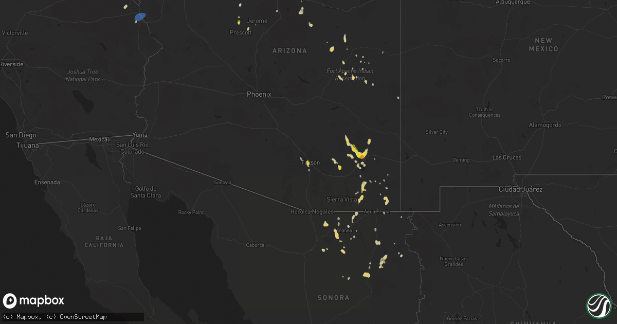
Hail Map on August 21, 2024
Get this storm
August 21 map
$229
one time, instant access
Download today. No call, no setup
Keep the $229
Bought the map and want the full workflow? Apply the entire $229 to a subscription within 7 days. None of it is wasted.
Every map, not just this one
This buys you this map. Subscription and you get every map we run, in the markets you choose from a few cities to whole states to nationwide. Plus real-time alerts the moment a storm fires.
Contact data
Name, contact info, occupancy, even credit band for addresses in the footprint. You go from where it hit to who to call.
Become the source they trust
Unlimited branding weather history reports on demand. You already have the documented answer ready for the property owner, and you are the one who showed up with it.
Property data and RoofTrace estimates
Pull up any address you have got, its value and the exact code rules for that jurisdiction, straight from One Click Code. Then RoofTrace estimates the squares, pitch, and roof value, priced the way you price.
States Impacted by Hail Map on August 21, 2024
Storm reports
New Mexico
| Date | Description |
|---|---|
| 08/20/202411:55 PM CDT | Heat burst detected on radar and surface observations. Awos station khmn holloman afb. |
| 08/20/20248:41 PM CDT | Asos station kfmn farmington airport. |
California
| Date | Description |
|---|---|
| 08/21/20246:45 PM CDT | Keed asos measured a peak wind gust to 60 mph as thunderstorm approached from the south. Blowing dust also noted on nearby webcam. |
| 08/20/20247:15 PM CDT | Keed asos gusted to 61 mph at 515 mph as another thunderstorm core moved overhead. |
| 08/20/20247:14 PM CDT | Corrects previous tstm wnd gst report from 6 s needles. Keed asos gusted to 66 mph at 514 mph as another thunderstorm core moved overhead. |
Nebraska
| Date | Description |
|---|---|
| 08/21/20246:34 PM CDT | Scottsbluff raws site. |
| 08/21/20246:14 PM CDT | Half dollar to golf ball sized hail reported by chaser between county road 17 and highway 71. |
| 08/21/20245:55 PM CDT | Chaser reported 50-60 mph microburst winds. |
| 08/21/202412:15 AM CDT | Awos station kggf grant airport. |
| 08/20/20249:34 PM CDT | Sidney asos. |
Montana
| Date | Description |
|---|---|
| 08/21/20246:46 PM CDT | 60 mph thunderstorm wind gust at geyser awos. |
| 08/20/202411:51 PM CDT | Asos station kbhk baker. |
| 08/20/20249:45 PM CDT | Mesonet station mtm28 5.2 e hoyt |
| 08/20/20249:18 PM CDT | A local report indicates 62 MPH wind near 6 E Poplar |
| 08/20/20249:15 PM CDT | Report from facebook. |
| 08/20/20248:53 PM CDT | Corrects previous hail report from 11 sw richey. Report from mping: ping pong ball |
| 08/20/20248:53 PM CDT | Asos station kolf wolf point airport. |
| 08/20/20248:25 PM CDT | E60 mph wind. |
| 08/20/20248:23 PM CDT | Report from facebook. |
| 08/20/20248:22 PM CDT | A local report indicates 1.00 inch wind near 5 SSW Vida |
| 08/20/20248:10 PM CDT | A local report indicates 1.00 inch wind near 10 S Vida |
| 08/20/20248:03 PM CDT | Small hail. |
| 08/20/20247:01 PM CDT | Hail up to quarter size falling. |
Arizona
| Date | Description |
|---|---|
| 08/21/20245:28 PM CDT | Personal weather station recorded gust to 58 mph. |
| 08/21/20245:25 PM CDT | Video on social media showing accumulating hail with the biggest hailstone being 1.5 inches in diameter. Another video at same location showed damage to car windshield |
| 08/21/20242:23 PM CDT | Trained spotter reported 1.25 inch accumulating hail. |
| 08/21/20242:21 PM CDT | Report from trained spotter of accumulating 1 inch hail. |
| 08/21/20242:11 PM CDT | Report from mping: quarter |
South Dakota
| Date | Description |
|---|---|
| 08/21/20246:30 PM CDT | A local report indicates 62 MPH wind near 11 SSW Oelrichs |
| 08/20/202410:20 PM CDT | Power outage from event time until 4 am the following morning. |
| 08/20/202410:14 PM CDT | Asos station kpir pierre muni ap. |
| 08/20/202410:10 PM CDT | A local report indicates 1.50 inch wind near 5 SE Capa |
| 08/20/202410:00 PM CDT | Mesonet station 168 foster bay |
| 08/20/20249:55 PM CDT | A local report indicates 60 MPH wind near 13 NE Kirley |
| 08/20/20249:54 PM CDT | Mesonet station 168 foster bay |
| 08/20/20249:40 PM CDT | Mesonet station 19 harrold |
| 08/20/20249:10 PM CDT | A local report indicates 60 MPH wind near 6 W Milesville |
| 08/20/20249:00 PM CDT | Golf ball to tennis ball size hail. |
| 08/20/20249:00 PM CDT | Picture of 1 inch hail sent via google voice. |
| 08/20/20248:24 PM CDT | A local report indicates 63 MPH wind near 3 NW Wasta |
| 08/20/20248:00 PM CDT | Marble to ping pong ball sized hail reported to have fallen. |
| 08/20/20247:50 PM CDT | A local report indicates 60 MPH wind near Porcupine |
| 08/20/20247:43 PM CDT | A local report indicates 2.00 inch wind near 8 ESE Ottumwa |
| 08/20/20247:01 PM CDT | A local report indicates 60 MPH wind near 13 W Oglala |
| 08/20/20247:00 PM CDT | A local report indicates 1.00 inch wind near 1 NNW Nemo |
Colorado
| Date | Description |
|---|---|
| 08/20/20248:22 PM CDT | Asos station kcez cortez municipal airport. |
Cities Impacted by Hail Map on August 21, 2024
- Prescott, AZ
- Chino Valley, AZ
- Tucson, AZ
- Pinetop, AZ
- Paulden, AZ
- Chadron, NE
- Saguache, CO
- Lakeside, AZ
- Show Low, AZ
- Prescott Valley, AZ
- Hay Springs, NE
- Elfrida, AZ
- Bisbee, AZ
- Ash Fork, AZ
- Willcox, AZ
- Heber, AZ
- Valentine, AZ
- Kingman, AZ
- Hackberry, AZ
- Tombstone, AZ
- Hemingford, NE
- Pearce, AZ
- Kadoka, SD
- Monte Vista, CO
- Williams, AZ
- Cochise, AZ
- Yoder, WY
- Opheim, MT
- Torrington, WY
- Lyman, NE
- Richland, MT
- Alamosa, CO
- Peerless, MT
- Benson, AZ
- Carter, MT
- Morrill, NE
- Gering, NE
- Philip, SD
- Loring, MT
- Floweree, MT
- Midland, SD
- Harrisburg, NE
- Scobey, MT
- Whitewater, MT
- Fort Benton, MT
- Albin, WY
- Pine Bluffs, WY
- Loma, MT
- Scottsbluff, NE
- Whitney, NE
- Edgemont, SD
- Oelrichs, SD
- Piedmont, SD
- Deadwood, SD
- Nemo, SD
- Sturgis, SD
- Okaton, SD
- Coffee Creek, MT
- Geraldine, MT
- Mohave Valley, AZ
- Needles, CA
- Topock, AZ
- Fort Pierre, SD
- Kimball, NE
- Minatare, NE
- Cheyenne, WY
- Burns, WY
- Pine Ridge, SD
- Hillsdale, WY
- Dix, NE
- Big Sandy, MT
- Kyle, SD
- Hayes, SD
- Fort Peck, MT
- Nashua, MT
- Jordan, MT
- Frazer, MT
- Union Center, SD
- Bayard, NE
- Potter, NE
- Box Elder, SD
- Carpenter, WY
- Dalton, NE
- Forsyth, MT
- Colstrip, MT
- Circle, MT
- Vida, MT
- Peridot, AZ
- Hilger, MT
- New Underwood, SD
- Bridgeport, NE
- Scenic, SD
- Wall, SD
- Enning, SD
- Lloyd, MT
- Batesland, SD
- Wounded Knee, SD
- Porcupine, SD
- Richey, MT
- Wasta, SD
- Owanka, SD
- Quinn, SD
- Martin, SD
- Bushnell, NE
- Broadwater, NE
- Volborg, MT
- New Raymer, CO
- Grover, CO
- Murdo, SD
- Allen, SD
- Milesville, SD
- Fallon, MT
- Glendive, MT
- Draper, SD
- Sidney, NE
- Stoneham, CO
- Padroni, CO
- Belvidere, SD
- Lisco, NE
- Cherry Creek, SD
- Cortez, CO
- Towaoc, CO
- Farmington, NM
- Kirtland, NM
- Bloomfield, NM
- Aztec, NM
- Flora Vista, NM
- Gurley, NE
- Peetz, CO
- Dupree, SD
- Eagle Butte, SD
- Iliff, CO
- Lodgepole, NE
- Oshkosh, NE
- Lewellen, NE
- Pierre, SD
- Blunt, SD
- Haxtun, CO
- Akron, CO
- Otis, CO
- Chappell, NE
- Crook, CO
- Holabird, SD
- Harrold, SD
- Onida, SD
- Highmore, SD
- Wolf Point, MT
- Poplar, MT
- Brockton, MT
- Froid, MT
- Culbertson, MT
- Fairview, MT
- Sedgwick, CO
- Sterling, CO
- Fleming, CO
- Big Springs, NE
- Cope, CO
- Anton, CO
- Java, SD
- Ashby, NE
- Arthur, NE
- Eureka, SD
- Mound City, SD
- Venango, NE
- Holyoke, CO
- Crosby, ND
- Bloomfield, MT
- Tioga, ND
- Max, ND
- Amherst, CO
- Minot, ND
- Sawyer, ND
- Hinsdale, MT
- Columbus, ND
- Brule, NE
- Ogallala, NE
- Grant, NE
- Paxton, NE
- Madrid, NE
- Elsie, NE
- Wallace, NE
- Watford City, ND
- Lignite, ND
- Portal, ND
- Velva, ND
- Bowbells, ND
- Flaxton, ND
- New Town, ND
- Steele, ND
- Norwich, ND
- Voltaire, ND
- Tuttle, ND
- Granville, ND
- Robinson, ND
- Sherwood, ND
- Karlsruhe, ND
- Lansford, ND
- Balfour, ND
- Dickens, NE
- Anamoose, ND
- Mohall, ND
- Maxbass, ND
- Pettibone, ND
- Tappen, ND
- Dawson, ND
- New Salem, ND
- Drake, ND
- Culbertson, NE
- Trenton, NE
- Rugby, ND
- Washburn, ND
- Mcclusky, ND
- Harvey, ND
- Goodrich, ND
- Sedona, AZ
- Grand Canyon, AZ
- McCook, NE
- Mercer, ND
- Denhoff, ND
- Martin, ND
- Danbury, NE
- Norton, KS
- Midway, AL
- Almena, KS
- Long Island, KS
- Prairie View, KS
- Logan, KS
- Phillipsburg, KS
- Glade, KS
- Kirwin, KS
- Luray, KS
- Lucas, KS
- Sylvan Grove, KS
- Lincoln, KS
- Kanopolis, KS
- Ellsworth, KS
- Brookville, KS