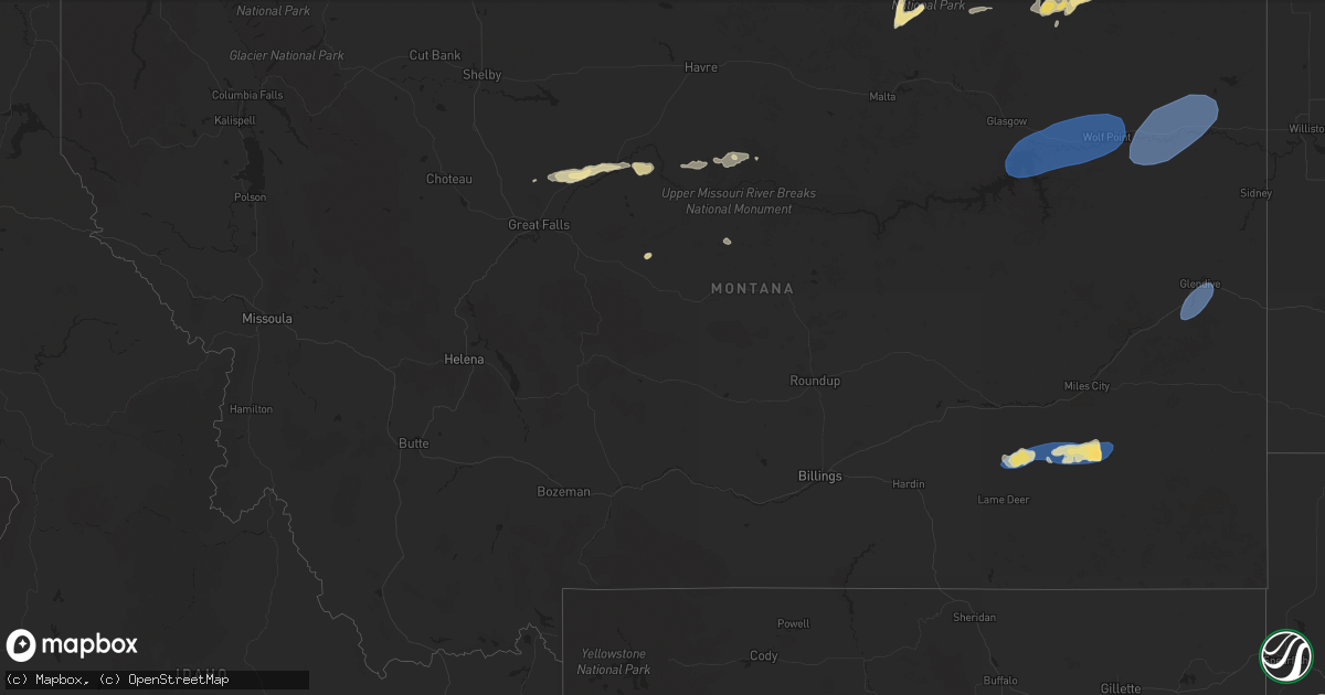
Hail Map in Montana on August 21, 2024
Get this storm
August 21 map
$229
one time, instant access
Download today. No call, no setup
Keep the $229
Bought the map and want the full workflow? Apply the entire $229 to a subscription within 7 days. None of it is wasted.
Every map, not just this one
This buys you this map. Subscription and you get every map we run, in the markets you choose from a few cities to whole states to nationwide. Plus real-time alerts the moment a storm fires.
Contact data
Name, contact info, occupancy, even credit band for addresses in the footprint. You go from where it hit to who to call.
Become the source they trust
Unlimited branding weather history reports on demand. You already have the documented answer ready for the property owner, and you are the one who showed up with it.
Property data and RoofTrace estimates
Pull up any address you have got, its value and the exact code rules for that jurisdiction, straight from One Click Code. Then RoofTrace estimates the squares, pitch, and roof value, priced the way you price.
Storm reports in Montana
Montana
| Date | Description |
|---|---|
| 08/21/20246:46 PM CDT | 60 mph thunderstorm wind gust at geyser awos. |
| 08/20/202411:51 PM CDT | Asos station kbhk baker. |
| 08/20/20249:45 PM CDT | Mesonet station mtm28 5.2 e hoyt |
| 08/20/20249:18 PM CDT | A local report indicates 62 MPH wind near 6 E Poplar |
| 08/20/20249:15 PM CDT | Report from facebook. |
| 08/20/20248:53 PM CDT | Corrects previous hail report from 11 sw richey. Report from mping: ping pong ball |
| 08/20/20248:53 PM CDT | Asos station kolf wolf point airport. |
| 08/20/20248:25 PM CDT | E60 mph wind. |
| 08/20/20248:23 PM CDT | Report from facebook. |
| 08/20/20248:22 PM CDT | A local report indicates 1.00 inch wind near 5 SSW Vida |
| 08/20/20248:10 PM CDT | A local report indicates 1.00 inch wind near 10 S Vida |
| 08/20/20248:03 PM CDT | Small hail. |
| 08/20/20247:01 PM CDT | Hail up to quarter size falling. |
All States Impacted by Hail Map on August 21, 2024
Cities Impacted by Hail Map on August 21, 2024
- Prescott, AZ
- Chino Valley, AZ
- Tucson, AZ
- Pinetop, AZ
- Paulden, AZ
- Chadron, NE
- Saguache, CO
- Lakeside, AZ
- Show Low, AZ
- Prescott Valley, AZ
- Hay Springs, NE
- Elfrida, AZ
- Bisbee, AZ
- Ash Fork, AZ
- Willcox, AZ
- Heber, AZ
- Valentine, AZ
- Kingman, AZ
- Hackberry, AZ
- Tombstone, AZ
- Hemingford, NE
- Pearce, AZ
- Kadoka, SD
- Monte Vista, CO
- Williams, AZ
- Cochise, AZ
- Yoder, WY
- Opheim, MT
- Torrington, WY
- Lyman, NE
- Richland, MT
- Alamosa, CO
- Peerless, MT
- Benson, AZ
- Carter, MT
- Morrill, NE
- Gering, NE
- Philip, SD
- Loring, MT
- Floweree, MT
- Midland, SD
- Harrisburg, NE
- Scobey, MT
- Whitewater, MT
- Fort Benton, MT
- Albin, WY
- Pine Bluffs, WY
- Loma, MT
- Scottsbluff, NE
- Whitney, NE
- Edgemont, SD
- Oelrichs, SD
- Piedmont, SD
- Deadwood, SD
- Nemo, SD
- Sturgis, SD
- Okaton, SD
- Coffee Creek, MT
- Geraldine, MT
- Mohave Valley, AZ
- Needles, CA
- Topock, AZ
- Fort Pierre, SD
- Kimball, NE
- Minatare, NE
- Cheyenne, WY
- Burns, WY
- Pine Ridge, SD
- Hillsdale, WY
- Dix, NE
- Big Sandy, MT
- Kyle, SD
- Hayes, SD
- Fort Peck, MT
- Nashua, MT
- Jordan, MT
- Frazer, MT
- Union Center, SD
- Bayard, NE
- Potter, NE
- Box Elder, SD
- Carpenter, WY
- Dalton, NE
- Forsyth, MT
- Colstrip, MT
- Circle, MT
- Vida, MT
- Peridot, AZ
- Hilger, MT
- New Underwood, SD
- Bridgeport, NE
- Scenic, SD
- Wall, SD
- Enning, SD
- Lloyd, MT
- Batesland, SD
- Wounded Knee, SD
- Porcupine, SD
- Richey, MT
- Wasta, SD
- Owanka, SD
- Quinn, SD
- Martin, SD
- Bushnell, NE
- Broadwater, NE
- Volborg, MT
- New Raymer, CO
- Grover, CO
- Murdo, SD
- Allen, SD
- Milesville, SD
- Fallon, MT
- Glendive, MT
- Draper, SD
- Sidney, NE
- Stoneham, CO
- Padroni, CO
- Belvidere, SD
- Lisco, NE
- Cherry Creek, SD
- Cortez, CO
- Towaoc, CO
- Farmington, NM
- Kirtland, NM
- Bloomfield, NM
- Aztec, NM
- Flora Vista, NM
- Gurley, NE
- Peetz, CO
- Dupree, SD
- Eagle Butte, SD
- Iliff, CO
- Lodgepole, NE
- Oshkosh, NE
- Lewellen, NE
- Pierre, SD
- Blunt, SD
- Haxtun, CO
- Akron, CO
- Otis, CO
- Chappell, NE
- Crook, CO
- Holabird, SD
- Harrold, SD
- Onida, SD
- Highmore, SD
- Wolf Point, MT
- Poplar, MT
- Brockton, MT
- Froid, MT
- Culbertson, MT
- Fairview, MT
- Sedgwick, CO
- Sterling, CO
- Fleming, CO
- Big Springs, NE
- Cope, CO
- Anton, CO
- Java, SD
- Ashby, NE
- Arthur, NE
- Eureka, SD
- Mound City, SD
- Venango, NE
- Holyoke, CO
- Crosby, ND
- Bloomfield, MT
- Tioga, ND
- Max, ND
- Amherst, CO
- Minot, ND
- Sawyer, ND
- Hinsdale, MT
- Columbus, ND
- Brule, NE
- Ogallala, NE
- Grant, NE
- Paxton, NE
- Madrid, NE
- Elsie, NE
- Wallace, NE
- Watford City, ND
- Lignite, ND
- Portal, ND
- Velva, ND
- Bowbells, ND
- Flaxton, ND
- New Town, ND
- Steele, ND
- Norwich, ND
- Voltaire, ND
- Tuttle, ND
- Granville, ND
- Robinson, ND
- Sherwood, ND
- Karlsruhe, ND
- Lansford, ND
- Balfour, ND
- Dickens, NE
- Anamoose, ND
- Mohall, ND
- Maxbass, ND
- Pettibone, ND
- Tappen, ND
- Dawson, ND
- New Salem, ND
- Drake, ND
- Culbertson, NE
- Trenton, NE
- Rugby, ND
- Washburn, ND
- Mcclusky, ND
- Harvey, ND
- Goodrich, ND
- Sedona, AZ
- Grand Canyon, AZ
- McCook, NE
- Mercer, ND
- Denhoff, ND
- Martin, ND
- Danbury, NE
- Norton, KS
- Midway, AL
- Almena, KS
- Long Island, KS
- Prairie View, KS
- Logan, KS
- Phillipsburg, KS
- Glade, KS
- Kirwin, KS
- Luray, KS
- Lucas, KS
- Sylvan Grove, KS
- Lincoln, KS
- Kanopolis, KS
- Ellsworth, KS
- Brookville, KS


