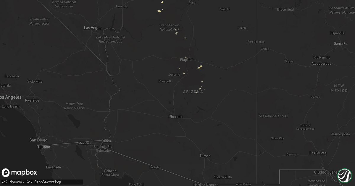
Hail Map in Arizona on August 17, 2021
Get this storm
August 17 map
$229
one time, instant access
Download today. No call, no setup
Keep the $229
Bought the map and want the full workflow? Apply the entire $229 to a subscription within 7 days. None of it is wasted.
Every map, not just this one
This buys you this map. Subscription and you get every map we run, in the markets you choose from a few cities to whole states to nationwide. Plus real-time alerts the moment a storm fires.
Contact data
Name, contact info, occupancy, even credit band for addresses in the footprint. You go from where it hit to who to call.
Become the source they trust
Unlimited branding weather history reports on demand. You already have the documented answer ready for the property owner, and you are the one who showed up with it.
Property data and RoofTrace estimates
Pull up any address you have got, its value and the exact code rules for that jurisdiction, straight from One Click Code. Then RoofTrace estimates the squares, pitch, and roof value, priced the way you price.
Storm reports in Arizona
Arizona
| Date | Description |
|---|---|
| 08/17/20217:59 AM CDT | At 1258 PM MST, a severe thunderstorm was located over Fort Valley, or 7 miles northwest of Flagstaff, and is nearly stationary. HAZARD...60 mph wind gusts and quarter size hail. SOURCE...Radar indicated. IMPACT...Hail damage to vehicles is expected. Expect wind damage to roofs, siding, and trees. Locations impacted include... Flagstaff, Fort Valley, Downtown Flagstaff, Hutchison Acres, Lockett Meadow Campground, Little Elden Spring Horse Camp and Arizona Snowbowl. |
| 08/17/20217:29 AM CDT | At 1228 PM MST, a severe thunderstorm was located 7 miles north of Forest Lakes, moving north at 5 mph. HAZARD...Quarter size hail. SOURCE...Radar indicated. IMPACT...Damage to vehicles is expected. Locations impacted include... Forest Lakes, Forest Road 169 Campground, Spillway Campground, Airplane Flat Campground, Gentry Campground, Canyon Point Campground, Forest Road 237 Camping Area, Rim Campground, Promontory Pit Road Campground, Woods Canyon Lake Campground, Canyon Creek Fish Hatchery, Black Canyon Rim Campground, Sinkhole Campground and Forest Road 171 Campground. |
| 08/17/20217:11 AM CDT | At 1210 AM MST, a severe thunderstorm was located near Valencia West and is nearly stationary. HAZARD...60 mph wind gusts and quarter size hail. SOURCE...Radar indicated. IMPACT...Hail damage to vehicles is expected. Expect wind damage to roofs, siding, and trees. Locations impacted include... Three Points, Pascua Pueblo Yaqui Reservation, Valencia West, Tucson Estates and Ryan AirField. |
| 08/17/20213:42 AM CDT | At 842 PM MST, a severe thunderstorm was located near Fredonia, moving east at 15 mph. HAZARD...60 mph wind gusts and quarter size hail. SOURCE...Radar indicated. IMPACT...Hail damage to vehicles is expected. Expect wind damage to roofs, siding, and trees. Locations impacted include... Fredonia. |
| 08/17/20212:18 AM CDT | At 718 PM MST, a severe thunderstorm was located over Davis-Monthan Air Force Base, moving northeast at 15 mph. HAZARD...60 mph wind gusts and quarter size hail. SOURCE...Radar indicated. IMPACT...Hail damage to vehicles is expected. Expect wind damage to roofs, siding, and trees. Locations impacted include... Tucson, Davis-Monthan Air Force Base, Tanque Verde, South Tucson, Tucson International Airport, Saguaro National Park East, Sabino Canyon Recreation Area, Catalina Foothills and Rita Ranch. |
| 08/16/202111:19 PM CDT | At 419 PM MST, a severe thunderstorm was located over Village At Oak Creek, or near Sedona, moving southeast at 10 mph. HAZARD...60 mph wind gusts and quarter size hail. SOURCE...Radar indicated. IMPACT...Hail damage to vehicles is expected. Expect wind damage to roofs, siding, and trees. Locations impacted include... Village At Oak Creek. |
| 08/16/202110:42 PM CDT | At 342 PM MST, a severe thunderstorm was located over Grandview Point At Grand Canyon, or 10 miles west of Desert View at Grand Canyon, and is nearly stationary. HAZARD...60 mph wind gusts and quarter size hail. SOURCE...Radar indicated. IMPACT...Hail damage to vehicles is expected. Expect wind damage to roofs, siding, and trees. Locations impacted include... Moran Point At Grand Canyon and Grandview Point At Grand Canyon. |
| 08/16/20219:33 PM CDT | Power poles down at benson hwy and palo verde. |
| 08/16/20219:32 PM CDT | Pole leaning on irvington east of campbell. |
| 08/16/20219:32 PM CDT | Cactus has fallen into the roadway at tucson blvd and drexel. |
| 08/16/20219:26 PM CDT | Wire down at irvington and tucson blvd. |
| 08/16/20219:24 PM CDT | Traffic light malfunctioning at irvington and country club. |
| 08/16/20219:21 PM CDT | Tree in roadway. |
| 08/16/20219:15 PM CDT | At 214 PM MST, a severe thunderstorm was located near Meteor Crater, or 22 miles west of Winslow, and is nearly stationary. HAZARD...60 mph wind gusts and quarter size hail. SOURCE...Radar indicated. IMPACT...Hail damage to vehicles is expected. Expect wind damage to roofs, siding, and trees. Locations impacted include... Two Guns, Rimmy Jims and Meteor Crater. |
| 08/16/20219:09 PM CDT | At 208 PM MST/308 PM MDT/, a severe thunderstorm was located 13 miles southeast of Desert View at Grand Canyon, and is nearly stationary. HAZARD...60 mph wind gusts and quarter size hail. SOURCE...Radar indicated. IMPACT...Hail damage to vehicles is expected. Expect wind damage to roofs, siding, and trees. This severe thunderstorm will remain over mainly rural areas of Coconino County. |
| 08/16/20218:28 PM CDT | At 127 PM MST, a severe thunderstorm was located near Tremaine Lake, or 30 miles southwest of Winslow, and is nearly stationary. HAZARD...60 mph wind gusts and quarter size hail. SOURCE...Radar indicated. IMPACT...Hail damage to vehicles is expected. Expect wind damage to roofs, siding, and trees. Locations impacted include... Tremaine Lake, Long Lake and Chavez Mountain. |
| 08/16/20218:21 PM CDT | At 120 PM MST, a severe thunderstorm was located 13 miles south of House Rock, or 37 miles north of Desert View at Grand Canyon, and is nearly stationary. HAZARD...60 mph wind gusts and quarter size hail. SOURCE...Radar indicated. IMPACT...Hail damage to vehicles is expected. Expect wind damage to roofs, siding, and trees. Locations impacted include... House Rock. |
| 08/16/20218:16 PM CDT | At 116 PM MST, a severe thunderstorm was located 8 miles southwest of Hualapai Hilltop, or 53 miles west of Desert View at Grand Canyon, moving northeast at 10 mph. HAZARD...60 mph wind gusts and quarter size hail. SOURCE...Radar indicated. IMPACT...Hail damage to vehicles is expected. Expect wind damage to roofs, siding, and trees. Locations impacted include... Hualapai Hilltop and Havasupai Reservation. |
All States Impacted by Hail Map on August 17, 2021
Cities Impacted by Hail Map on August 17, 2021
- Colorado City, AZ
- Fredonia, AZ
- Sedona, AZ
- Payson, AZ
- Delta, UT
- Hinckley, UT
- Dryden, TX
- Fillmore, UT
- Grand Canyon, AZ
- Sherwood, ND
- Del Rio, TX
- Mount Pleasant, UT
- Flagstaff, AZ
- Warsaw, MO
- Dugway, UT
- Canton, TX
- Kenmare, ND
- Beaver, UT
- Mabank, TX
- Calumet, OK
- North Rim, AZ
- Mount Vernon, TX
- Talco, TX
- Garrison, UT
- Stover, MO
- Mora, MO
- Florence, MO
- Ben Wheeler, TX
- Monroe, UT
- Tuba City, AZ
- Bartlett, TX
- Immokalee, FL
- Labelle, FL
- Sherman, TX
- Nephi, UT
- Springville, UT
- Archie, MO
- Adrian, MO
- Centerview, MO
- Warrensburg, MO
- Deepwater, MO
- Windsor, MO
- Green Ridge, MO
- Pond Creek, OK
- Salt Lake City, UT
- Midvale, UT
- Sandy, UT
- Provo, UT
- Wallsburg, UT
- Orem, UT


