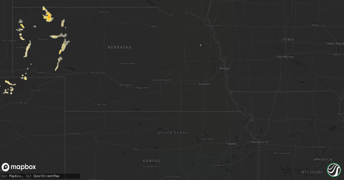
Hail Map in Nebraska on August 14, 2022
Get this storm
August 14 map
$229
one time, instant access
Download today. No call, no setup
Keep the $229
Bought the map and want the full workflow? Apply the entire $229 to a subscription within 7 days. None of it is wasted.
Every map, not just this one
This buys you this map. Subscription and you get every map we run, in the markets you choose from a few cities to whole states to nationwide. Plus real-time alerts the moment a storm fires.
Contact data
Name, contact info, occupancy, even credit band for addresses in the footprint. You go from where it hit to who to call.
Become the source they trust
Unlimited branding weather history reports on demand. You already have the documented answer ready for the property owner, and you are the one who showed up with it.
Property data and RoofTrace estimates
Pull up any address you have got, its value and the exact code rules for that jurisdiction, straight from One Click Code. Then RoofTrace estimates the squares, pitch, and roof value, priced the way you price.
Storm reports in Nebraska
Nebraska
| Date | Description |
|---|---|
| 08/14/20224:00 AM CDT | At 900 PM MDT, a severe thunderstorm was located near Antioch, or 11 miles east of Alliance, moving northeast at 20 mph. HAZARD...60 mph wind gusts and quarter size hail. SOURCE...Radar indicated. IMPACT...Hail damage to vehicles is expected. Expect wind damage to roofs, siding, and trees. Locations impacted include... Ellsworth, Antioch, Patterson Lake, Kincaid Lake, Kennedy Lake, Wild Horse Flats, Snow Lake, Miles Lake, Wickson Lake, Diamond Lake, Lakeside, Herman Lake, Jerry Lake, Krause Lake and Tralnor Lake.This includes the following highways... Highway 250 between mile markers 1 and 22. Highway 2 between mile markers 96 and 126. |
| 08/14/20223:51 AM CDT | At 851 PM MDT, severe thunderstorms were located along a line extending from 7 miles northeast of Box Butte Dam to near Wild Horse Butte to near Antioch, moving northeast at 20 mph. HAZARD...60 mph wind gusts. SOURCE...Radar indicated. IMPACT...Expect damage to roofs, siding, and trees. Locations impacted include... Alliance, Hemingford, Wild Horse Butte, Berea, Alliance Airport and Box Butte Dam. |
| 08/14/20222:56 AM CDT | At 755 PM MDT, severe thunderstorms were located along a line extending from Lake Minatare to 6 miles southwest of Chimney Rock State Park to near Redington, moving northeast at 15 mph. HAZARD...60 mph wind gusts and quarter size hail. SOURCE...Radar indicated. IMPACT...Hail damage to vehicles is expected. Expect wind damage to roofs, siding, and trees. Locations impacted include... Bridgeport, Bayard, Minatare, Lake Minatare Campground, Northport, Chimney Rock State Park, Bridgeport State Recreation Area, Angora, Kilpatrick Lake, The Intersection Of Highway 385 And 92, Court House And Jail Rocks, Moomaws Corner, Redington, Lake Minatare, The Intersection Of Highway 385 And L62, South Bayard Junction, Melbeta and McGrew. |
| 08/14/20222:12 AM CDT | At 712 PM MDT, a severe thunderstorm was located near Hay Springs, moving southeast at 20 mph. HAZARD...60 mph wind gusts and quarter size hail. SOURCE...Radar indicated. IMPACT...Hail damage to vehicles is expected. Expect wind damage to roofs, siding, and trees. Locations impacted include... Rushville, Hay Springs, Clinton, Lone Butte, Intersection of Beaver Creek Road and White Clay Creek Road, Intersection of Highway 87 and Antelope Road and Walgren Lake State Recreation Area.This includes the following highways... Highway 20 between mile markers 74 and 98. Highway 250 between mile markers 40 and 48. |
| 08/13/20229:53 PM CDT | A local report indicates 64 MPH wind near ALLIANCE |
| 08/13/20229:00 PM CDT | A local report indicates 60 MPH wind near 6 NE MINATARE |
| 08/13/20228:25 PM CDT | Trained spotter estimated 60 mph winds on the north side of hay springs. |
All States Impacted by Hail Map on August 14, 2022
Cities Impacted by Hail Map on August 14, 2022
- Manville, WY
- Grover, CO
- Berthoud, CO
- Harrison, NE
- Kimball, NE
- Gordon, NE
- Dateland, AZ
- Garrett, WY
- Towner, ND
- Briggsdale, CO
- Williams, AZ
- Rifle, CO
- Ellsworth, NE
- Dix, NE
- Chandler, AZ
- Platteville, CO
- Marsland, NE
- Carr, CO
- Mead, CO
- Westhope, ND
- Golden Valley, AZ
- Padroni, CO
- Mayer, AZ
- Minatare, NE
- Ashby, NE
- Oshkosh, NE
- Bingham, NE
- Gilbert, AZ
- Hay Springs, NE
- Rushville, NE
- Chadron, NE
- Pine Ridge, SD
- Lakeside, NE
- Lewellen, NE
- Chappell, NE
- Taylorsville, NC
- Crown King, AZ
- Kingman, AZ
- Bristol, TN
- Bluff City, TN
- Ault, CO
- Longmont, CO
- Orchard, CO
- Laveen, AZ
- Florence, AZ
- Harrisburg, NE
- Hurley, NM
- Mohave Valley, AZ
- Gering, NE
- Melbeta, NE
- Bayard, NE
- Salome, AZ
- Merriman, NE
- Potter, NE
- Beemer, NE
- Kirkland, AZ
- Alliance, NE
- Wittmann, AZ
- New Raymer, CO


