Hail Map in Arizona on August 14, 2022
Get this storm
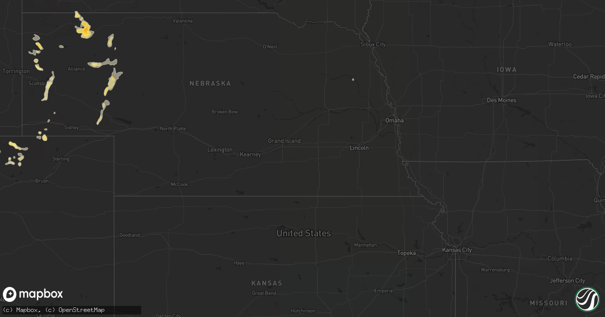
August 14 map
$229
one time, instant access
Download today. No call, no setup
Keep the $229
Bought the map and want the full workflow? Apply the entire $229 to a subscription within 7 days. None of it is wasted.
Every map, not just this one
This buys you this map. Subscription and you get every map we run, in the markets you choose from a few cities to whole states to nationwide. Plus real-time alerts the moment a storm fires.
Contact data
Name, contact info, occupancy, even credit band for addresses in the footprint. You go from where it hit to who to call.
Become the source they trust
Unlimited branding weather history reports on demand. You already have the documented answer ready for the property owner, and you are the one who showed up with it.
Property data and RoofTrace estimates
Pull up any address you have got, its value and the exact code rules for that jurisdiction, straight from One Click Code. Then RoofTrace estimates the squares, pitch, and roof value, priced the way you price.
Storm reports in Arizona
Arizona
| Date | Description |
|---|---|
| 08/14/20226:02 PM CDT | Power poles down along w patton rd. |
| 08/14/20225:26 PM CDT | Power pole |
| 08/14/20226:55 AM CDT | At 1153 AM MST, a severe thunderstorm was located near Cherry, or 8 miles southwest of Camp Verde along Interstate 17, moving southeast at 5 mph. HAZARD...Quarter size hail with 40 mph wind gusts. SOURCE...Radar indicated. IMPACT...Damage to vehicles is expected. This severe thunderstorm will be over Interstate 17 10 miles southwest of Camp Verde. |
| 08/14/20222:16 AM CDT | At 715 PM PDT, a severe thunderstorm was located over Overton, moving south at 25 mph. HAZARD...60 mph wind gusts. SOURCE...Radar indicated. IMPACT...Expect damage to roofs and trees. Locations impacted include... Overton, Moapa Town, Moapa Valley, Echo Bay, Valley Of Fire, Overton Beach, Echo Bay Campground, Logandale, Bunkerville and Lake Mead National Recreation Area.This includes Interstate 15 in Nevada between mile markers 90 and115. |
| 08/14/20221:30 AM CDT | At 630 PM MST, a severe thunderstorm was located 7 miles east of Dateland, or 42 miles northwest of Ajo, moving northeast at 10 mph. HAZARD...60 mph wind gusts and quarter size hail. SOURCE...Radar indicated. IMPACT...Hail damage to vehicles is expected. Expect wind damage to roofs, siding, and trees. Locations impacted include... Sentinel, Paloma and Dateland. This includes AZ Interstate 8 between mile markers 66 and 92. |
| 08/14/202212:14 AM CDT | At 514 PM MST, a severe thunderstorm was located near Sun Lakes, moving east at 15 mph. HAZARD...60 mph wind gusts and penny size hail. SOURCE...Radar indicated. IMPACT...Expect damage to roofs, siding, and trees. Locations impacted include... Mesa, Chandler, Gilbert, Tempe, Sun Lakes, Maricopa, Queen Creek, Chandler Heights, Gilbert City Hall, Tumbleweed Park, Chandler City Hall, San Tan Village Mall, Seville, Freestone Park and Bapchule.This includes the following highways...AZ Interstate 10 between mile markers 157 and 182.US Highway 60 between mile markers 184 and 185.AZ Route 87 between mile markers 146 and 171. |
| 08/13/202211:43 PM CDT | At 442 PM MST, a severe thunderstorm was located near Estrella Mountain Park, or 11 miles southeast of Avondale, moving northeast at 10 mph. HAZARD...60 mph wind gusts and quarter size hail. SOURCE...Radar indicated. IMPACT...Hail damage to vehicles is expected. Expect wind damage to roofs, siding, and trees. Locations impacted include... Phoenix, Avondale, Goodyear, Laveen, South Mountain Park, Phoenix International Raceway, South Phoenix, Estrella Mountain Park, Rainbow Valley and Komatke. |
| 08/13/202211:13 PM CDT | At 413 PM MST, a severe thunderstorm was located 9 miles south of Estrella Mountain Ranch, or 14 miles southeast of Buckeye, and is nearly stationary. HAZARD...60 mph wind gusts and penny size hail. SOURCE...Radar indicated. IMPACT...Expect damage to roofs, siding, and trees. Locations impacted include... Phoenix, Avondale, Goodyear, Buckeye, Tolleson, Cashion, Estrella, Litchfield Park, Palo Verde, Perryville, Liberty, Phoenix International Raceway, Estrella Sailport, Sonoran National Monument and Estrella Mountain Park.This includes the following highways...AZ Interstate 10 between mile markers 111 and 138.AZ Route 101 between mile markers 2 and 3.AZ Route 238 between mile markers 12 and 39. |
| 08/13/202210:58 PM CDT | At 358 PM MST, a severe thunderstorm was located near Beardsley, or near Sun City West, moving southeast at 20 mph. HAZARD...60 mph wind gusts and penny size hail. SOURCE...Radar indicated. IMPACT...Expect damage to roofs, siding, and trees. Locations impacted include... Phoenix, Glendale, Peoria, Surprise, Avondale, El Mirage, Youngtown, Sun City West, Waddell, Circle City, Sun City, Wittmann, Litchfield Park, Deer Valley Airport and White Tank Mountain Park.This includes the following highways...AZ Interstate 17 between mile markers 210 and 219.US Highway 60 between mile markers 121 and 156.AZ Route 101 between mile markers 3 and 25. |
| 08/13/202210:23 PM CDT | At 323 PM MST, a severe thunderstorm was located near Morristown, or near Circle City, moving northeast at 5 mph. HAZARD...60 mph wind gusts. SOURCE...Radar indicated. IMPACT...Expect damage to roofs, siding, and trees. Locations impacted include... Surprise, Wickenburg, Wittmann, Sun City West, Circle City, Lake Pleasant, Morristown, Beardsley and Vistancia.This includes the following highways...US Highway 60 between mile markers 93 and 141.AZ Route 74 between mile markers 1 and 24.AZ Route 303 between mile markers 117 and 132. |
| 08/13/202210:17 PM CDT | At 316 PM MST, a severe thunderstorm was located over Sycamore Creek, and is nearly stationary. HAZARD...60 mph wind gusts. SOURCE...Radar indicated. IMPACT...Expect damage to roofs, siding, and trees. Locations impacted include... Round Valley, Sycamore Creek, Sunflower, Ballantine Trailhead, Punkin Center and Tonto Basin.This includes the following highways...AZ Route 87 between mile markers 210 and 229.AZ Route 188 between mile markers 254 and 266. |
| 08/13/202210:09 PM CDT | At 308 PM MST, severe thunderstorms were located along a line extending from near Camp Creek to New River, and are nearly stationary. HAZARD...60 mph wind gusts. SOURCE...Radar indicated. IMPACT...Expect damage to roofs, siding, and trees. Locations impacted include... Scottsdale, Round Valley, New River, Sycamore Creek, Cave Creek, Carefree, Desert Mountain, Camp Creek, Rio Verde, Horseshoe Reservoir, Anthem and Seven Springs.This includes the following highways...AZ Interstate 17 between mile markers 224 and 241.AZ Route 87 near mile marker 213. |
| 08/13/20227:40 PM CDT | Large tree toppled and leaning on a home. |
| 08/13/20227:15 PM CDT | Power lines down. |
All States Impacted by Hail Map on August 14, 2022
Cities Impacted by Hail Map on August 14, 2022
- Manville, WY
- Grover, CO
- Berthoud, CO
- Harrison, NE
- Kimball, NE
- Gordon, NE
- Dateland, AZ
- Garrett, WY
- Towner, ND
- Briggsdale, CO
- Williams, AZ
- Rifle, CO
- Ellsworth, NE
- Dix, NE
- Chandler, AZ
- Platteville, CO
- Marsland, NE
- Carr, CO
- Mead, CO
- Westhope, ND
- Golden Valley, AZ
- Padroni, CO
- Mayer, AZ
- Minatare, NE
- Ashby, NE
- Oshkosh, NE
- Bingham, NE
- Gilbert, AZ
- Hay Springs, NE
- Rushville, NE
- Chadron, NE
- Pine Ridge, SD
- Lakeside, NE
- Lewellen, NE
- Chappell, NE
- Taylorsville, NC
- Crown King, AZ
- Kingman, AZ
- Bristol, TN
- Bluff City, TN
- Ault, CO
- Longmont, CO
- Orchard, CO
- Laveen, AZ
- Florence, AZ
- Harrisburg, NE
- Hurley, NM
- Mohave Valley, AZ
- Gering, NE
- Melbeta, NE
- Bayard, NE
- Salome, AZ
- Merriman, NE
- Potter, NE
- Beemer, NE
- Kirkland, AZ
- Alliance, NE
- Wittmann, AZ
- New Raymer, CO


