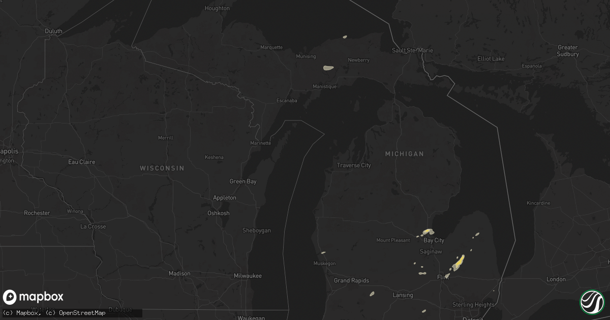
Hail Map in Michigan on August 12, 2025
Get this storm
August 12 map
$229
one time, instant access
Download today. No call, no setup
Keep the $229
Bought the map and want the full workflow? Apply the entire $229 to a subscription within 7 days. None of it is wasted.
Every map, not just this one
This buys you this map. Subscription and you get every map we run, in the markets you choose from a few cities to whole states to nationwide. Plus real-time alerts the moment a storm fires.
Contact data
Name, contact info, occupancy, even credit band for addresses in the footprint. You go from where it hit to who to call.
Become the source they trust
Unlimited branding weather history reports on demand. You already have the documented answer ready for the property owner, and you are the one who showed up with it.
Property data and RoofTrace estimates
Pull up any address you have got, its value and the exact code rules for that jurisdiction, straight from One Click Code. Then RoofTrace estimates the squares, pitch, and roof value, priced the way you price.
Storm reports in Michigan
Michigan
| Date | Description |
|---|---|
| 08/12/20256:50 PM CDT | Two trees uprooted near 24 mile rd and dequindre rd. |
| 08/12/20255:47 PM CDT | Trees and power lines reported down in fostoria... As well as the mayville area. |
| 08/12/20255:47 PM CDT | Photos of partially destroyed barn in addition to a roof half peeled off. Number of trees reported damaged. |
| 08/12/20255:31 PM CDT | Corrects previous non-tstm wnd gst report from 1 sse springfield. Asos station kbtl battle creek executive airport. |
| 08/12/20255:15 PM CDT | 20 trees reported blown down across mostly the southern portions of the county. Power lines also downed. |
| 08/12/20255:10 PM CDT | Several trees downed... Along with power lines and tree branchs. Flint area also had one tree reported down. |
| 08/12/20254:38 PM CDT | Sporadic tree damage... With a number of large trees uprooted and tree limbs downed across the neighborhood. Some of the tree damage resulted in downed power lines. Min |
| 08/12/20254:37 PM CDT | Trees and power lines observed down... As well as a collapsed barn. |
| 08/12/20252:56 PM CDT | Fire dept. Reports several trees down that took down wires on the southeast side of grand rapids. |
| 08/12/20252:56 PM CDT | Fire dept. |
| 08/11/20257:45 PM CDT | Wires down near fred |
| 08/11/20257:45 PM CDT | Wires down near fred w moore hwy and wadhams rd. |
All States Impacted by Hail Map on August 12, 2025
Cities Impacted by Hail Map on August 12, 2025
- McIntire, IA
- Stacyville, IA
- Whitehall, MI
- Riceville, IA
- Twin Lake, MI
- Chester, IA
- Alton, IL
- East Alton, IL
- Wood River, IL
- New Lenox, IL
- Manhattan, IL
- Washburn, IL
- Dorsey, IL
- Frankfort, IL
- Florissant, MO
- Bunker Hill, IL
- Dwight, IL
- Minonk, IL
- Benson, IL
- Saint Louis, MO
- West Alton, MO
- Granite City, IL
- East Saint Louis, IL
- Mokena, IL
- Madison, IL
- Lovejoy, IL
- Venice, IL
- Edwardsville, IL
- Wilmington, IL
- Elwood, IL
- Joliet, IL
- Hartford, IL
- Hammond, IN
- Chicago, IL
- East Carondelet, IL
- Tinley Park, IL
- Orland Park, IL
- Evergreen Park, IL
- Gardner, IL
- Oak Forest, IL
- Emington, IL
- Odell, IL
- Bradford, AR
- Maroa, IL
- Gustine, TX
- Jasper, IN
- Dubois, IN
- Kenney, IL
- Celestine, IN
- Rockport, IN
- Goldthwaite, TX
- Essex, IL
- Braidwood, IL
- Braceville, IL
- Mount Pulaski, IL
- Pontiac, IL
- Chestnut, IL
- Warrensburg, IL
- Jonesville, IN
- Columbus, IN
- Washington, IN
- Montgomery, IN
- Richland, IN
- Freeport, MI
- Hastings, MI
- Lake Odessa, MI
- Latham, IL
- Santa Anna, TX
- Coal City, IL
- Stone Park, IL
- Melrose Park, IL
- Elmwood Park, IL
- Lincolnwood, IL
- River Grove, IL
- Boonville, IN
- Chrisney, IN
- Tennyson, IN
- Kopperl, TX
- Hico, TX
- Menard, TX
- Forsyth, IL
- Hamilton, TX
- Del Rio, TX
- Taswell, IN
- Saint Peters, MO
- Birdseye, IN
- Cicero, IL
- Cleburne, TX
- Newberry, MI
- Decatur, IL
- Godley, TX
- Galesburg, MI
- Climax, MI
- Gatesville, TX
- Jonesboro, TX
- Paoli, IN
- English, IN
- Clifton, AZ
- Plano, TX
- Manistique, MI
- Silver City, NM
- Arenas Valley, NM
- Linwood, MI
- Augusta, MI
- San Saba, TX
- Kawkawlin, MI
- Midland, MI
- Auburn, MI
- Rio Vista, TX
- Marengo, IN
- Clifton, TX
- Hillsboro, TX
- Labelle, FL
- Palmyra, IN
- Glenwood, NM
- Buckhorn, NM
- Baskin, LA
- Brant, MI
- Elsie, MI
- Depauw, IN
- Llano, TX
- Grand Blanc, MI
- Burton, MI
- Flint, MI
- Pinconning, MI
- Burkett, TX
- Coleman, TX
- Otisville, MI
- Union Star, KY
- Corydon, IN
- Mason, TX
- Doss, TX
- Battle Creek, MI
- Bay City, MI
- Lapeer, MI
- Davison, MI
- Terre Haute, IN
- Lewis, IN
- Pimento, IN
- Riley, IN
- Brazil, IN
- Cory, IN
- Rising Star, TX
- Cross Plains, TX
- Brownwood, TX
- Morocco, IN
- Brook, IN
- Owosso, MI
- Henderson, MI
- Stephensport, KY
- Castell, TX
- Clay City, IL
- Flora, IL
- Dahlonega, GA
- Columbiaville, MI
- Chesaning, MI
- Clay City, IN
- Centerpoint, IN
- Coal City, IN
- Fair Oaks, IN
- Leakey, TX
- Inverness, FL
- Corunna, MI
- Hubbard, TX
- North Branch, MI
- Fostoria, MI
- Otter Lake, MI
- Mayville, MI
- Cleveland, GA
- Rensselaer, IN
- Rhodelia, KY
- Silverwood, MI
- Mount Ayr, IN
- Payson, AZ
- Olney, IL
- Hardinsburg, KY
- Webster, KY
- Bridgeport, IL
- Clifford, MI
- Channahon, IL
- Cisco, TX
- Flat Rock, IL
- Shelburn, IN
- Farmersburg, IN
- Burnet, TX
- Morgantown, KY
- Sullivan, IN
- New Franken, WI
- Crestwood, KY
- Louisville, KY
- Prospect, KY
- Marble Falls, TX
- Pembroke, GA
- Marlette, MI
- Kingston, MI
- Decker, MI
- Cannelton, IN
- Cass City, MI
- Breckenridge, MI
- Lawrenceville, IL
- Grayville, IL
- Ubly, MI
- Jetson, KY
- Dryden, TX
- Pewee Valley, KY
- Rome, IN
- Reno, NV
- Taloga, OK
- Putnam, OK
- Gregory, MI
- Stockbridge, MI
- Eckerman, MI
- Douglas, AZ
- Oaktown, IN
- Pine, AZ
- Allendale, IL
- Vincennes, IN
- Kinross, MI
- Brimley, MI
- Evansville, IN
- Patoka, IN
- Decker, IN
- Hazleton, IN
- East China, MI
- Princeton, IN
- Francisco, IN
- Chandler, IN
- Petersburg, IN
- Cincinnati, OH
- Sault Sainte Marie, MI
- Cleves, OH
- North Bend, OH
- Gentryville, IN
- Dragoon, AZ
- Dale, IN
- Loogootee, IN
- Clarksburg, OH
- Chillicothe, OH
- Frankfort, OH
- Huntingburg, IN
- Ferdinand, IN
- Williamsport, OH
- Custer, MT
- Delhi, LA
- Rayville, LA
- Forsyth, MT
- Bighorn, MT
- Delaware, OH
- Monon, IN
- Wolf Point, MT


