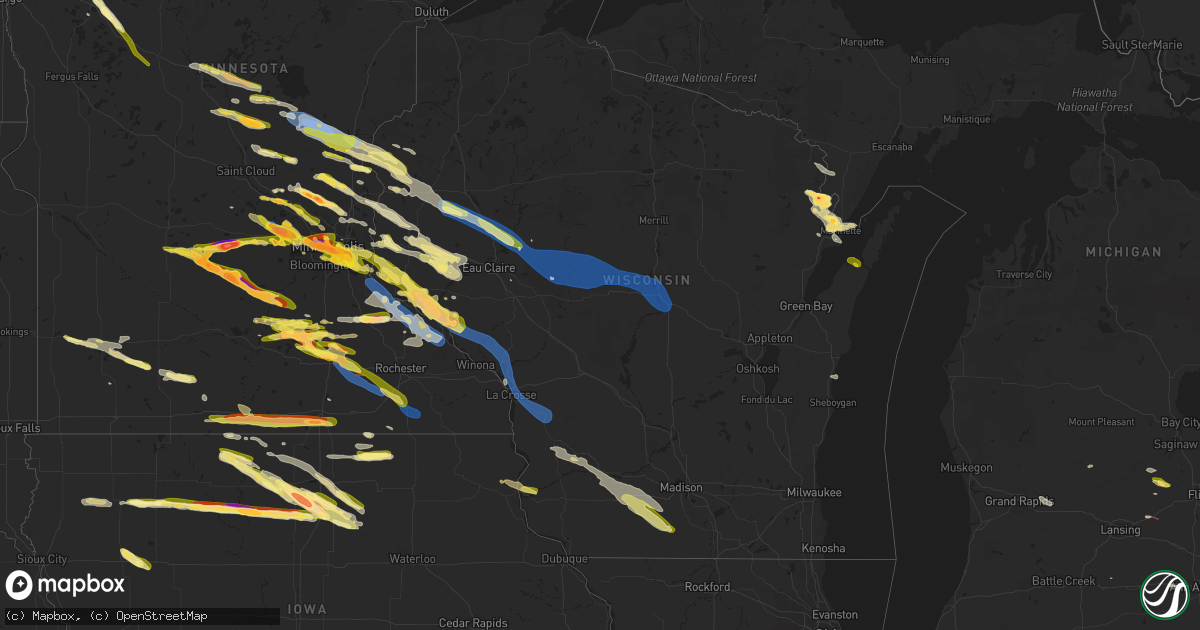
Hail Map in Wisconsin on August 11, 2023
Get this storm
August 11 map
$229
one time, instant access
Download today. No call, no setup
Keep the $229
Bought the map and want the full workflow? Apply the entire $229 to a subscription within 7 days. None of it is wasted.
Every map, not just this one
This buys you this map. Subscription and you get every map we run, in the markets you choose from a few cities to whole states to nationwide. Plus real-time alerts the moment a storm fires.
Contact data
Name, contact info, occupancy, even credit band for addresses in the footprint. You go from where it hit to who to call.
Become the source they trust
Unlimited branding weather history reports on demand. You already have the documented answer ready for the property owner, and you are the one who showed up with it.
Property data and RoofTrace estimates
Pull up any address you have got, its value and the exact code rules for that jurisdiction, straight from One Click Code. Then RoofTrace estimates the squares, pitch, and roof value, priced the way you price.
Storm reports in Wisconsin
Wisconsin
| Date | Description |
|---|---|
| 08/11/20236:54 PM CDT | Report forwarded by wbay-tv. Time estimated from radar. |
| 08/11/20236:53 PM CDT | A local report indicates 1.00 inch wind near 1 N Loyal |
| 08/11/20236:47 PM CDT | A local report indicates 70 MPH wind near Loyal |
| 08/11/20236:40 PM CDT | Picture via broadcast media on twitter. Size estimated based on picture between 2 and 2.5 inches. |
| 08/11/20236:40 PM CDT | Delayed report up to golf ball sized hail. Picture via twitter. |
| 08/11/20236:33 PM CDT | A local report indicates 60 MPH wind near Longwood |
| 08/11/20236:30 PM CDT | Estimated hail up to 2 inches... Relayed via broadcast media through nwschat. |
| 08/11/20236:20 PM CDT | A local report indicates 1.25 inch wind near 4 NNW Bay City |
| 08/11/20236:09 PM CDT | A local report indicates 1.00 inch wind near 4 N Cadott |
| 08/11/20236:03 PM CDT | Small trees down. |
| 08/11/20235:42 PM CDT | A local report indicates 1.00 inch wind near 3 W Menomonie |
| 08/11/20235:33 PM CDT | A local report indicates 1.25 inch wind near 1 E Knapp |
| 08/11/20235:30 PM CDT | A few medium to large trees down and large branches snapped... Pictures via facebook comments. Also up to nickel sized hail. |
| 08/11/20235:30 PM CDT | Corrects previous tstm wnd dmg report from bloomer. A few medium to large trees down and large branches snapped... Pictures via facebook comments. Also up to nickel siz |
| 08/11/20235:17 PM CDT | A local report indicates 1.00 inch wind near 4 ENE Hudson |
| 08/11/20234:30 PM CDT | Tree down on power line... Size unknown. |
| 08/11/20233:55 PM CDT | Power pole snapped from winds. |
| 08/11/20233:55 PM CDT | Mentioned a few quarter sized hail. |
| 08/10/202310:47 PM CDT | Delayed report. Large tree branch down on a car. A few other large tree branches down. Time estimated from radar. |
| 08/10/202310:45 PM CDT | A local report indicates 1.00 inch wind near 1 E Albany |
| 08/10/20239:08 PM CDT | Richland county sheriffs office reported tree down blocking the road. Time estimated via radar. |
| 08/10/20239:00 PM CDT | Trees downed. Time estimated from radar. |
| 08/10/20238:55 PM CDT | 50mph winds reported with power outages in ripon. |
| 08/10/20238:54 PM CDT | Multiple trees and wires down. |
| 08/10/20238:40 PM CDT | Trempealeau sheriffs office reported trees down on county road k. Time estimated via radar. |
| 08/10/20238:24 PM CDT | Multiple reports of many power lines down and loss of power. Time estimated via radar. |
| 08/10/20238:23 PM CDT | Most damage 60 to 70 mph with isolated peaks to 80 mph with larger snapped maple trees. Time estimated via radar. |
| 08/10/20238:20 PM CDT | Delayed report. Trees down northwest of big falls. The time of this report is an estimate based on radar data. |
| 08/10/20238:05 PM CDT | Report from mping: 1-inch tree limbs broken; shingles blown off. |
| 08/10/20238:05 PM CDT | Buffalo cty sheriffs office passed along power line down. |
| 08/10/20238:04 PM CDT | La crosse county sheriffs office reported tree |
| 08/10/20238:01 PM CDT | La crosse county sheriffs office reported 8 trees down within the city of la crosse. Time estimated via radar. |
| 08/10/20238:01 PM CDT | Asos station klse la crosse regional airport. |
| 08/10/20237:56 PM CDT | A local report indicates 60 MPH wind near Onalaska |
| 08/10/20237:55 PM CDT | Report from mping: 3-inch tree limbs broken; power poles broken. |
| 08/10/20237:46 PM CDT | Measured at coop station plow3. |
| 08/10/20237:43 PM CDT | Report from mping: 3-inch tree limbs broken; power poles broken. |
| 08/10/20237:41 PM CDT | Large tree blown down. |
| 08/10/20237:40 PM CDT | Corrects previous tstm wnd dmg report from 3 ne trempealeau. Trempealeau sheriffs office reported trees down on county road k. Time estimated via radar. |
| 08/10/20237:35 PM CDT | Delayed report from social media. Tree down on highway 39 in kronenwetter. The time of this report is an estimate based on radar data. |
| 08/10/20237:29 PM CDT | Delayed report from social media. Tree... Power pole... And power line down in mosinee. The time of this report is an estimate based on radar data. |
| 08/10/20237:18 PM CDT | Jackson county sheriffs office passed along trees down near wazee lake. Time estimated via radar. |
| 08/10/20237:15 PM CDT | Buffalo county sheriffs office reported a porta potty blown across state rd. Time estimated via radar. |
| 08/10/20237:10 PM CDT | 1 downed tree on powerline at 6th and ash in marshfield. Time estimated. |
All States Impacted by Hail Map on August 11, 2023
Cities Impacted by Hail Map on August 11, 2023
- Bellevue, TX
- Bowie, TX
- Prague, OK
- Sparks, OK
- Wataga, IL
- Cameron, IL
- Aledo, IL
- Henderson, IL
- Rio, IL
- North Henderson, IL
- Oneida, IL
- Alexis, IL
- Galesburg, IL
- Gilson, IL
- Elmwood, IL
- Knoxville, IL
- Victoria, IL
- Williamsfield, IL
- Dahinda, IL
- East Galesburg, IL
- Farmington, IL
- Hanna City, IL
- Manito, IL
- Trivoli, IL
- Mapleton, IL
- Kingston Mines, IL
- Fairview, IL
- Yates City, IL
- Peoria, IL
- Brimfield, IL
- Canton, IL
- Edwards, IL
- Maquon, IL
- Glasford, IL
- Norris, IL
- Abingdon, IL
- London Mills, IL
- East Peoria, IL
- Peoria Heights, IL
- Princeville, IL
- Creve Coeur, IL
- Dunlap, IL
- Pekin, IL
- Morton, IL
- Monmouth, IL
- Gerlaw, IL
- Groveland, IL
- Washington, IL
- Laura, IL
- Emden, IL
- Green Valley, IL
- Mackinaw, IL
- Armington, IL
- Minier, IL
- Delavan, IL
- South Pekin, IL
- Tremont, IL
- Hopedale, IL
- Hunnewell, MO
- Paris, MO
- Havana, IL
- Rushville, IL
- Moberly, MO
- Marshall, MO
- Centerview, MO
- Holden, MO
- Palmyra, MO
- Lewistown, IL
- Camp Point, IL
- Astoria, IL
- Higbee, MO
- Armstrong, MO
- Liberty, IL
- Quincy, IL
- Browning, IL
- Kingsville, MO
- Mount Sterling, IL
- Shelbina, MO
- Sweet Springs, MO
- Forest City, IL
- Topeka, IL
- Payson, IL
- Glasgow, MO
- Slater, MO
- Gilliam, MO
- Warrensburg, MO
- Holliday, MO
- Monroe City, MO
- Madison, MO
- Timewell, IL
- Huntsville, MO
- Hannibal, MO
- Concordia, MO
- Clayton, IL
- Warsaw, IL
- Logan, KS
- Fillmore, MO
- Saint Patrick, MO
- Spickard, MO
- Bremen, KS
- Colchester, IL
- Esbon, KS
- Table Grove, IL
- Seneca, KS
- Smithfield, IL
- Beattie, KS
- Craig, MO
- Forest City, MO
- Bethany, MO
- Falls City, NE
- Kirwin, KS
- Trenton, MO
- Guilford, MO
- Macomb, IL
- Glade, KS
- Formoso, KS
- Cuba, KS
- Mound City, MO
- Gorin, MO
- Mankato, KS
- Axtell, KS
- Washington, KS
- Gilman City, MO
- Galt, MO
- Pattonsburg, MO
- Cedar, KS
- Hamilton, IL
- Baileyville, KS
- Greentop, MO
- King City, MO
- Rea, MO
- Morrowville, KS
- Adair, IL
- Lenora, KS
- Rexford, KS
- Alexandria, MO
- Home, KS
- Kirksville, MO
- Memphis, MO
- Tennessee, IL
- Oketo, KS
- Gaylord, KS
- Hill City, KS
- Morland, KS
- Albany, MO
- Bolckow, MO
- Green City, MO
- Basco, IL
- Summerfield, KS
- Selden, KS
- Colby, KS
- McFall, MO
- Wyaconda, MO
- Kahoka, MO
- Du Bois, NE
- Maitland, MO
- Brashear, MO
- Oregon, MO
- Ipava, IL
- Baring, MO
- Marysville, KS
- Plymouth, IL
- Belleville, KS
- Scandia, KS
- Milan, MO
- Haddam, KS
- Phillipsburg, KS
- Green Castle, MO
- Courtland, KS
- Dawson, NE
- Bern, KS
- Hanover, KS
- Rutledge, MO
- Sabetha, KS
- Humboldt, NE
- Darlington, MO
- Salem, NE
- Liverpool, IL
- Novinger, MO
- Carthage, IL
- Edina, MO
- Rulo, NE
- Narka, KS
- Friend, NE
- Dorchester, NE
- Crete, NE
- Wilber, NE
- Western, NE
- De Witt, NE
- Beatrice, NE
- Pickrell, NE
- Filley, NE
- Auburn, AL
- Opelika, AL
- Waverly, AL
- Grapevine, AR
- Spearville, KS
- Alexander City, AL
- Carthage, AR
- Linn, KS
- Agenda, KS
- Greenleaf, KS
- Arkadelphia, AR
- Clyde, KS
- Clifton, KS
- Jacksons Gap, AL
- Dadeville, AL
- Palmer, KS
- Nauvoo, IL
- Morganville, KS
- Talladega, AL
- Ashland, AL
- Offerle, KS
- Poyen, AR
- Malvern, AR
- Sheridan, AR
- Leola, AR
- Ingalls, KS
- Camp Hill, AL
- Notasulga, AL
- Auburn University, AL
- Swanton, NE
- Milligan, NE
- Columbiana, AL
- Wilsonville, AL
- Amity, AR
- Blue Springs, NE
- Virginia, NE
- Liberty, NE
- Burchard, NE
- Pawnee City, NE
- Steinauer, NE
- Lewiston, NE
- Pillager, MN
- Motley, MN
- Fort Ripley, MN
- Brainerd, MN
- Baxter, MN
- Rockford, AL
- Sylacauga, AL
- Equality, AL
- Kellyton, AL
- Pierz, MN
- Hillman, MN
- Little Falls, MN
- Eclectic, AL
- Cook, NE
- Talmage, NE
- Brock, NE
- Ogilvie, MN
- Mora, MN
- Braham, MN
- Grasston, MN
- Stanchfield, MN
- Pine City, MN
- Onamia, MN
- Milaca, MN
- Rush City, MN
- Foley, MN
- Oak Park, MN
- Foreston, MN
- Princeton, MN
- Harris, MN
- Grantsburg, WI
- North Branch, MN
- Cambridge, MN
- Isanti, MN
- Blomkest, MN
- Lake Lillian, MN
- Saint Croix Falls, WI
- Elk River, MN
- Zimmerman, MN
- Stacy, MN
- Anoka, MN
- Cosmos, MN
- Cedar, MN
- Tyler, MN
- Balaton, MN
- Ruthton, MN
- Hector, MN
- Buffalo Lake, MN
- Buffalo, MN
- Waverly, MN
- Andover, MN
- Wyoming, MN
- Litchfield, MN
- Hutchinson, MN
- Darwin, MN
- Big Lake, MN
- Becker, MN
- Delano, MN
- Rockford, MN
- Loretto, MN
- Garvin, MN
- Stewart, MN
- Brownton, MN
- Glencoe, MN
- Cokato, MN
- Dassel, MN
- Silver Lake, MN
- Howard Lake, MN
- New Auburn, MN
- Arlington, MN
- Maple Lake, MN
- Green Isle, MN
- Hamel, MN
- Minneapolis, MN
- Long Lake, MN
- Wayzata, MN
- Watertown, MN
- Montrose, MN
- Currie, MN
- Westbrook, MN
- Storden, MN
- Jeffers, MN
- Hopkins, MN
- Maple Plain, MN
- Saint Paul, MN
- Henderson, MN
- Roberts, WI
- Hudson, WI
- Belle Plaine, MN
- Hammond, WI
- New Richmond, WI
- Wilson, WI
- Woodville, WI
- Glenwood City, WI
- Knapp, WI
- New Prague, MN
- Le Sueur, MN
- Le Center, MN
- Menomonie, WI
- South Saint Paul, MN
- Inver Grove Heights, MN
- Newport, MN
- Saint Paul Park, MN
- Mendota, MN
- Prescott, WI
- Hastings, MN
- Cottage Grove, MN
- River Falls, WI
- Afton, MN
- Beldenville, WI
- Hager City, WI
- Ellsworth, WI
- Elk Mound, WI
- Spring Valley, WI
- Eau Galle, WI
- Elmwood, WI
- Lakeland, MN
- Dallas, WI
- Clayton, WI
- Barron, WI
- Prairie Farm, WI
- Ridgeland, WI
- Chetek, WI
- New Auburn, WI
- Cleveland, MN
- Waterville, MN
- Kilkenny, MN
- Morristown, MN
- Bloomer, WI
- Wheeler, WI
- Chippewa Falls, WI
- Jim Falls, WI
- Cadott, WI
- Colfax, WI
- Windom, MN
- Mountain Lake, MN
- Bingham Lake, MN
- Butterfield, MN
- Boyd, WI
- Stanley, WI
- Thorp, WI
- Augusta, WI
- Mankato, MN
- Kasota, MN
- Elysian, MN
- Madison Lake, MN
- Saint Peter, MN
- Waseca, MN
- Janesville, MN
- Owatonna, MN
- Bay City, WI
- Warsaw, MN
- Faribault, MN
- Medford, MN
- Maiden Rock, WI
- Plum City, WI
- Stockholm, WI
- Arkansaw, WI
- Pepin, WI
- Owosso, MI
- Oakley, MI
- Chesaning, MI
- Greenwood, WI
- Withee, WI
- Owen, WI
- Willard, WI
- New Lothrop, MI
- Corunna, MI
- Claremont, MN
- Colby, WI
- Loyal, WI
- Curtiss, WI
- Unity, WI
- Spencer, WI
- Montgomery, MN
- Neillsville, WI
- Blooming Prairie, MN
- Fairmont, MN
- Pawhuska, OK
- Granada, MN
- Bartlesville, OK
- Nelson, WI
- Blue Earth, MN
- Dodge Center, MN
- Hayfield, MN
- Duke, OK
- Olustee, OK
- Elmer, OK
- Altus, OK
- Annandale, MN
- South Haven, MN
- Clearwater, MN
- Balsam Lake, WI
- Centuria, WI
- Rice, MN
- Sauk Rapids, MN
- Goodwater, AL
- Percival, IA
- Monticello, MN
- Saint Francis, MN
- Hackensack, MN
- Backus, MN
- Longville, MN
- Sheridan, MO
- Hallock, MN
- Montgomery, AL
- Walnut Grove, MN
- Detroit Lakes, MN
- Frazee, MN
- Perham, MN
- Baldwin, WI
- Kimball, MN
- Frederic, WI
- Siren, WI
- Marbury, AL
- Deatsville, AL
- Osseo, MN
- Champlin, MN
- Monroe, MI
- La Salle, MI
- Corinth, MS
- Rienzi, MS
- McRae Helena, GA
- Lumber City, GA
- Saint Helena Island, SC
- Saint Michael, MN
- Rogers, MN
- Wetumpka, AL
- Staples, MN
- Cushing, MN
- Tracy, MN
- Verbena, AL
- Prattville, AL
- Elmore, AL
- Morris, GA
- Coleman, GA
- Cuthbert, GA
- Shelby, AL
- Weogufka, AL
- Star Prairie, WI
- Arkansas City, KS
- Luck, WI
- Folly Beach, SC
- Forest Lake, MN
- Hurtsboro, AL
- Pittsview, AL
- Eufaula, AL
- Royalton, MN
- Calhoun, GA
- Gaylord, MN
- Bolivar, TN
- Newington, GA
- Audubon, MN
- Callaway, MN
- Hugo, MN
- Stillwater, MN
- Whiteville, TN
- Dexter, MI
- Chelsea, MI
- Ann Arbor, MI
- Childersburg, AL
- Center City, MN
- Dalton, GA
- Cushing, WI
- Deer Park, WI
- Dayton, MN
- Hatchechubbee, AL
- Winsted, MN
- Clay Center, KS
- Walnut, MS
- Seale, AL
- Lindstrom, MN
- Daviston, AL
- Titus, AL
- Fort Gaines, GA
- Bethel Springs, TN
- Finger, TN
- Georgetown, GA
- Lewis, KS
- Hilton Head Island, SC
- Kinsley, KS
- Somerville, TN
- Osceola, WI
- Bethel, MN
- Milltown, WI
- Turtle Lake, WI
- Adairsville, GA
- Henderson, TN
- Coolidge, GA
- Moultrie, GA
- Bluffton, GA
- Edison, GA
- Houlton, WI
- Somerset, WI
- Byers, KS
- Macksville, KS
- Haviland, KS
- Americus, GA
- Crystal, MI
- Carson City, MI
- Minnetonka, MN
- Johns Island, SC
- Charleston, SC
- Amery, WI
- Tallassee, AL
- Salem, AL
- Pike Road, AL
- Thomasville, GA
- Boston, GA
- Slayton, MN
- Milan, GA
- Jacksonville, GA
- Albertville, MN
- Elk City, OK
- Lake Elmo, MN
- Mayer, MN
- Prinsburg, MN
- Maple Grove, MN
- Hanover, MN
- Raymond, MN
- Nicollet, MN
- Mound, MN
- Niagara, ND
- Inkster, ND
- Cohutta, GA
- Cleveland, TN
- Chatsworth, GA
- Circle Pines, MN
- Shafer, MN
- Chisago City, MN
- Scandia, MN
- Felda, FL
- Canute, OK
- Butler, OK
- Clinton, OK
- Foss, OK
- Kasson, MN
- Elmore, MN
- Frost, MN
- Perry, MI
- Barnsdall, OK
- Ramona, OK
- Ochelata, OK
- Arapaho, OK
- Morrice, MI
- Granton, WI
- Chili, WI
- Marshfield, WI
- Alma, WI
- Durand, WI
- Nowata, OK
- Wabasha, MN
- Talala, OK
- Chelsea, OK
- Fountain City, WI
- Cochrane, WI
- Arcadia, WI
- Ettrick, WI
- Trempealeau, WI
- Galesville, WI
- Dodge, WI
- New York Mills, MN
- Oologah, OK
- Wadena, MN
- Deer Creek, MN
- Grand Meadow, MN
- Racine, MN
- Byron, MN
- Spring Valley, MN
- Stewartville, MN
- Waltham, MN
- Sargeant, MN
- Dexter, MN
- Bricelyn, MN
- Kiester, MN
- Claremore, OK
- Wells, MN
- Glenville, MN
- Conger, MN
- Twin Lakes, MN
- Albert Lea, MN
- Alden, MN
- Emmons, MN
- Weatherford, OK
- Custer City, OK
- Hayward, MN
- Lonsdale, MN
- Kenyon, MN
- West Concord, MN
- Austin, MN
- Holmen, WI
- Onalaska, WI
- La Crosse, WI
- Cannon Falls, MN
- Dennison, MN
- Goodhue, MN
- Zumbrota, MN
- Wanamingo, MN
- Thomas, OK
- Wykoff, MN
- Preston, MN
- Fenton, IA
- Armstrong, IA
- Lone Rock, IA
- Swea City, IA
- Bancroft, IA
- Burt, IA
- Titonka, IA
- Wesley, IA
- Lakota, IA
- Coon Valley, WI
- Sutherland, IA
- Peterson, IA
- Linn Grove, IA
- Auburndale, WI
- Mosinee, WI
- Stratford, WI
- Milladore, WI
- Junction City, WI
- Stevens Point, WI
- Plover, WI
- Taloga, OK
- Oakwood, OK
- Sioux Rapids, IA
- Stoddard, WI
- Chaseburg, WI
- Cashton, WI
- Westby, WI
- Viroqua, WI
- Britt, IA
- Corwith, IA
- Woden, IA
- Saint Ansgar, IA
- Osage, IA
- Little Cedar, IA
- Riceville, IA
- Webb, IA
- Stephenson, MI
- Wausaukee, WI
- Sturgeon Bay, WI
- Watonga, OK
- Geary, OK
- Greenfield, OK
- Canton, OK
- Fay, OK
- Omega, OK
- Okarche, OK
- Kingfisher, OK
- Hitchcock, OK
- Loyal, OK
- Curlew, IA
- Laurens, IA
- Ayrshire, IA
- Mallard, IA
- Havelock, IA
- Garner, IA
- Wallace, MI
- Porterfield, WI
- Menominee, MI
- Marinette, WI
- Red Wing, MN
- Klemme, IA
- Goodell, IA
- Meservey, IA
- Alexander, IA
- Thornton, IA
- Livermore, IA
- Bode, IA
- Ottosen, IA
- Dover, OK
- Cashion, OK
- Hennessey, OK
- Rolfe, IA
- West Bend, IA
- Lu Verne, IA
- Hardy, IA
- Renwick, IA
- Latimer, IA
- Swaledale, IA
- Sheffield, IA
- Hampton, IA
- Rockwell, IA
- Mason City, IA
- Dougherty, IA
- Marble Rock, IA
- Rockford, IA
- Greene, IA
- Kanawha, IA
- Clear Lake, IA
- Crescent, OK
- Gentry, MO
- Stanberry, MO
- Coffey, MO
- Jameson, MO
- Jamesport, MO
- Goldfield, IA
- Belmond, IA
- Clarion, IA
- Chapin, IA
- Aredale, IA
- Dumont, IA
- Holstein, IA
- Galva, IA
- Birmingham, AL
- Bessemer, AL
- Helena, AL
- Pelham, AL
- Calera, AL
- Alabaster, AL
- Schaller, IA
- Douglas, OK
- Covington, OK
- Fairmont, OK
- Garber, OK
- Perry, OK
- Lincoln, AR
- Summers, AR
- Canehill, AR
- Prairie Grove, AR
- West Fork, AR
- Chester, AR
- Mountainburg, AR
- Winslow, AR
- Billings, OK
- Red Rock, OK
- Odebolt, IA
- Early, IA
- Blue Mounds, WI
- Barneveld, WI
- Hollandale, WI
- Mount Horeb, WI
- Blanchardville, WI
- Dodgeville, WI
- Ridgeway, WI
- Monticello, WI
- New Glarus, WI
- Belleville, WI
- Prairie Du Chien, WI
- Chillicothe, MO
- Chula, MO
- New Hampton, MO
- Unionville, MO
- Worthington, MO
- Queen City, MO
- Albany, WI
- Mount Hope, WI
- Woodman, WI
- Mulberry, AR
- Alma, AR
- Wheeling, MO
- Linneus, MO
- Eagleville, MO
- Ridgeway, MO
- South Haven, KS
- Braman, OK
- Geuda Springs, KS
- Winfield, KS
- Meadville, MO
- Cainsville, MO
- Blythedale, MO
- Princeton, MO
- Denver, MO
- Grant City, MO
- Ozark, AR
- Dexter, KS
- Burden, KS
- Cambridge, KS
- Martinsville, MO
- Browning, MO
- Laredo, MO
- Humphreys, MO
- Burnsville, MS
- Counce, TN
- Michie, TN
- Rochester, MN
- Zumbro Falls, MN
- Plainview, MN
- Elgin, MN
- Millville, MN
- Saint James, MN
- Okeene, OK
- Granville, IA
- Paullina, IA
- Cleghorn, IA
- Ravenwood, MO
- Clyde, MO
- Redding, IA
- Blockton, IA
- Eldorado, OK
- Gould, OK
- Marathon, IA
- Eau Claire, WI
- Kellogg, MN
- Albion, MI
- Springport, MI
- Henderson, MI
- Kellerton, IA
- Mount Ayr, IA
- Georgiana, AL
- McKenzie, AL
- Leland, IA
- Forest City, IA
- Ventura, IA
- Fertile, IA
- Thompson, IA
- Dundas, MN
- Northfield, MN
- Empire, AL
- Bremen, AL
- Lake City, MN
- Lipscomb, TX
- Higgins, TX
- Crivitz, WI
- Elba, AL
- Marine On Saint Croix, MN
- Fall Creek, WI
- Wheeler, TX
- Mobeetie, TX
- Briscoe, TX
- Cleveland, WI
- Ceylon, MN
- Sherburn, MN
- Truman, MN
- Welcome, MN
- Winnebago, MN
- Lucien, OK
- Cordova, AL
- Jasper, AL
- Peshtigo, WI
- Mears, MI
- Clanton, AL
- Billingsley, AL
- Ringsted, IA
- Algona, IA
- Hope Hull, AL
- Letohatchee, AL
- Nerstrand, MN
- Welch, MN
- Quanah, TX
- Altoona, WI
- Ledyard, IA
- Hatfield, MO
- Joice, IA
- Buffalo Center, IA
- Alpine, AL
- Newkirk, OK
- Pembine, WI
- Daggett, MI
- Almena, WI
- Quinton, AL
- Adamsville, AL
- Dora, AL
- Hopkins, MO
- Bison, OK
- Waukomis, OK
- Mondovi, WI
- Downing, WI
- Excelsior, MN
- Waycross, GA
- Blackshear, GA
- Maryville, MO
- Trimont, MN
- Jemison, AL
- Paris, AR
- Altus, AR
- Reads Landing, MN
- Shidler, OK
- Millbrook, AL
- Rose Creek, MN
- Lyle, MN
- Egg Harbor, WI
- Brunswick, GA
- Spavinaw, OK
- Salina, OK
- Fulda, MN
- Evansville, AR
- Natural Dam, AR
- Mazeppa, MN
- Bovey, MN
- Arlington, GA
- Blakely, GA
- Twin Valley, MN
- La Crescent, MN
- Russellville, AL
- Waverly, GA
- Chelsea, AL
- Flushing, MI
- Pleasant Grove, AL
- Fairfield, AL
- Fayetteville, AR
- Farmington, AR
- Pine Island, MN
- Flint, MI
- Warrior, AL
- Mangum, OK
- Canton, OH
- Worth, MO
- Uvalda, GA
- Adair, OK
- Morrow, AR
- Frontenac, MN
- Eden Prairie, MN
- Bird Island, MN
- Manly, IA
- Kensett, IA
- Grafton, IA
- Purdin, MO
- Williamstown, MO
- Brookfield, MO
- Sutter, IL
- West Point, IL
- Laclede, MO
- Altura, MN
- Bowen, IL
- Marceline, MO
- Rothville, MO
- Keytesville, MO
- Salisbury, MO
- New Cambria, MO
- Mendon, MO
- Clifton Hill, MO
- Callao, MO
- Louisiana, MO
- Clarksville, MO
- Nebo, IL
- Clark, MO
- Sturgeon, MO
- Centralia, MO
- Hallsville, MO
- Bowling Green, MO
- Thompson, MO
- Mexico, MO
- Auxvasse, MO
- Martinsburg, MO
- Benton City, MO
- Laddonia, MO
- Rush Hill, MO
- Wellsville, MO
- Farber, MO
- Vandalia, MO
- Bellflower, MO
- Montgomery City, MO
- Middletown, MO
- Columbia, MO
- Curryville, MO
- Silex, MO
- Eolia, MO
- Hawk Point, MO
- Truxton, MO
- High Hill, MO
- Troy, MO
- Foristell, MO
- Elsberry, MO
- Moscow Mills, MO
- Wentzville, MO
- Wright City, MO
- Old Monroe, MO
- Foley, MO
- Winfield, MO
- Brussels, IL
- Golden Eagle, IL
- O'Fallon, MO
- Lake Saint Louis, MO
- Saint Charles, MO
- Saint Peters, MO
- Saint Louis, MO
- Chesterfield, MO
- Florissant, MO
- Bridgeton, MO
- Maryland Heights, MO
- Hazelwood, MO
- Saint Ann, MO
- Earth City, MO
- Anabel, MO
- Clarence, MO
- Sarcoxie, MO
- Gallatin, MO
- Ethel, MO
- Conway Springs, KS
- Milton, KS
- East Canton, OH
- Fieldon, IL
- Jerseyville, IL
- Hardin, IL
- Harpers Ferry, IA
- McGregor, IA
- Monona, IA
- Norwich, KS
- Clarks Grove, MN
- Hollandale, MN
- Harris, MO
- New London, MO
- Center, MO
- Spivey, KS
- Frankford, MO
- McCune, KS
- Hamburg, IL
- Lentner, MO
- Wright, KS
- Novelty, MO
- Ada, MI
- Lowell, MI
- Arena, WI
- Spring Green, WI
- Macon, MO
- Bevier, MO
- Waukon, IA
- Dorchester, IA
- Lansing, IA
- Pawnee, IL
- Auburn, IL
- Chatham, IL
- Glenarm, IL
- Divernon, IL
- Newtown, MO
- Bethel, MO
- Philadelphia, MO
- Emden, MO
- Hurdland, MO
- Heyworth, IL
- Shirley, IL
- McLean, IL
- Verona, WI
- Leon, KS
- Knox City, MO
- Monticello, MO
- La Belle, MO
- Canton, MO
- Lock Springs, MO
- Wauzeka, WI
- Waterville, IA
- Luana, IA
- Rockport, IL
- Blue River, WI
- Muscoda, WI
- Rosemount, MN
- Garden City, KS
- Eagle Lake, MN
- Winigan, MO
- Altoona, KS
- Thayer, KS
- Neodesha, KS
- Galesburg, KS
- Chanute, KS
- Augusta, IL
- Keokuk, IA
- Elvaston, IL
- Shelby, MI
- Gays Mills, WI
- Richland Center, WI
- Soldiers Grove, WI
- Avoca, WI
- Lone Rock, WI
- Minter, AL
- Camden, AL
- Parsons, KS
- Ashburn, MO
- Saint Paul, KS
- Walnut, KS
- Girard, KS
- Plover, IA
- Joplin, MO
- Novi, MI
- Bedford, IA
- Parnell, MO
- Ewing, MO
- Wellington, KS
- Stacyville, IA
- Bristow, IA
- Maywood, MO
- Shelbyville, MO
- Durham, MO
- Newark, MO
- Bucklin, KS
- Greensburg, KS
- Augusta, KS
- Morrison, OK
- Fredonia, KS
- Bucklin, MO
- Lockwood, MO
- Golden City, MO
- Pollock, MO
- Ormsby, MN
- Thorsby, AL
- New Boston, MO
- Humboldt, KS
- Pittsburg, KS
- Arma, KS
- Franklin, KS
- Nora Springs, IA
- Stilwell, OK
- Eureka, MO
- Wildwood, MO
- Ballwin, MO
- Valley Park, MO
- Pacific, MO
- High Ridge, MO
- House Springs, MO
- Arnold, MO
- Imperial, MO
- Fenton, MO
- Barnhart, MO
- Utica, MO
- Mindenmines, MO
- Coatesville, IN
- Lamar, MO
- Liberal, MO
- Decorah, IA
- Fall River, KS
- Sullivan, MO
- Gifford, IL
- Potomac, IL
- Rankin, IL
- Thomasboro, IL
- Penfield, IL
- Hoopeston, IL
- Rantoul, IL
- Rossville, IL
- Bismarck, IL
- Danville, IL
- Alvin, IL
- Paxton, IL
- Loda, IL
- Melvin, IL
- Brunswick, MO
- Dalton, MO
- Le Roy, MN
- Taopi, MN
- Bicknell, IN
- Edwardsport, IN
- Carlisle, IN
- Freelandville, IN
- Oaktown, IN
- Stover, MO
- Cole Camp, MO
- Edwardsville, IL
- Glen Carbon, IL
- Rocheport, MO
- Fulton, MO
- Warrenton, MO
- Godfrey, IL
- Dow, IL
- Monrovia, IN
- Martinsville, IN
- Clayton, IN
- Mooresville, IN
- Bainbridge, IN
- Fillmore, IN
- Carbon, IN
- Bridgeton, IN
- Rosedale, IN
- Rockville, IN
- Harrisburg, MO
- Fayette, MO
- Beaufort, MO
- Mansfield, IL
- Bethalto, IL
- Savonburg, KS
- Elsmore, KS
- Lees Summit, MO
- Grain Valley, MO
- Raymore, MO
- Lone Jack, MO
- Pleasant Hill, MO
- Overland Park, KS
- Belton, MO
- Greenwood, MO
- Kansas City, MO
- Stilwell, KS
- Grandview, MO
- Gibson City, IL
- Ludlow, IL
- Elliott, IL
- Greencastle, IN
- Gravois Mills, MO
- Sandborn, IN
- La Harpe, KS
- Sumner, MO
- Moran, KS
- Chandlerville, IL
- Bath, IL
- Frederick, IL
- Beardstown, IL
- Alhambra, IL
- Marine, IL
- Grafton, IL
- Versailles, MO
- Bloomington, IL
- Stanford, IL
- Le Roy, IL
- Downs, IL
- Erie, KS
- Grand Tower, IL
- Mora, MO
- Reeds, MO
- Gerald, MO
- New Haven, MO
- Rocky Mount, MO
- Union, MO
- Covington, IN
- Adams, MN
- Eldon, MO
- Veedersburg, IN
- Williamsport, IN
- East Alton, IL
- Alton, IL
- Cottage Hills, IL
- Moro, IL
- Brighton, IL
- Kingman, KS
- Potosi, MO
- Altamont, MO
- Montezuma, IN
- Mecca, IN
- Hillsdale, IN
- Carlinville, IL
- Greenfield, IL
- Hettick, IL
- Chesterfield, IL
- Colony, KS
- Kincaid, KS
- Welda, KS
- Leslie, MO
- Rosebud, MO
- Owensville, MO
- Ionia, MO
- Sedalia, MO
- Lincoln, MO
- Green Ridge, MO
- Mulberry, KS
- Waynetown, IN
- Allison, IA
- Iola, KS
- Carthage, MO
- Benedict, KS


