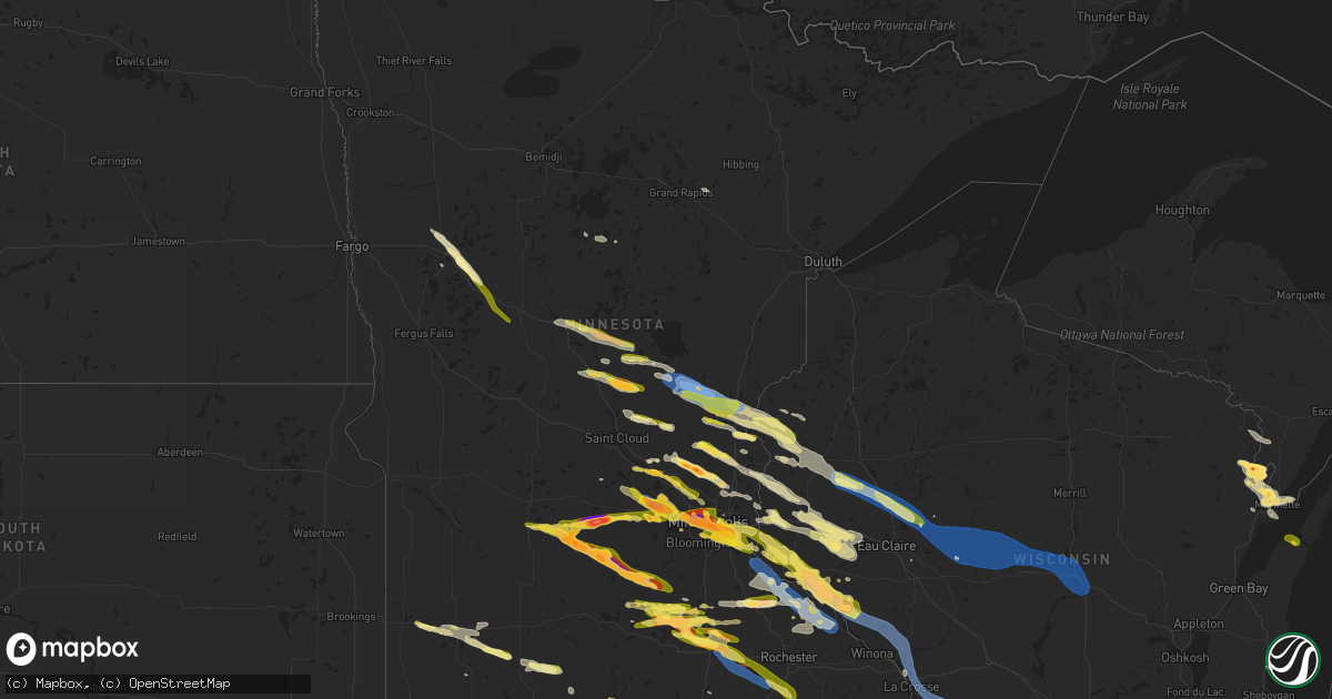
Hail Map in Minnesota on August 11, 2023
Get this storm
August 11 map
$229
one time, instant access
Download today. No call, no setup
Keep the $229
Bought the map and want the full workflow? Apply the entire $229 to a subscription within 7 days. None of it is wasted.
Every map, not just this one
This buys you this map. Subscription and you get every map we run, in the markets you choose from a few cities to whole states to nationwide. Plus real-time alerts the moment a storm fires.
Contact data
Name, contact info, occupancy, even credit band for addresses in the footprint. You go from where it hit to who to call.
Become the source they trust
Unlimited branding weather history reports on demand. You already have the documented answer ready for the property owner, and you are the one who showed up with it.
Property data and RoofTrace estimates
Pull up any address you have got, its value and the exact code rules for that jurisdiction, straight from One Click Code. Then RoofTrace estimates the squares, pitch, and roof value, priced the way you price.
Storm reports in Minnesota
Minnesota
| Date | Description |
|---|---|
| 08/11/20236:58 PM CDT | Corrects time of previous tstm wnd dmg report from claremont. Grain elevator/bin sustained considerable damage from strong winds. |
| 08/11/20236:50 PM CDT | Off duty park ranger reported dime to quarter sized hail. Power is out and many trees are down in area. |
| 08/11/20236:48 PM CDT | Several tree limbs down near the mississippi river. |
| 08/11/20236:40 PM CDT | A local report indicates 1.25 inch wind near 2 W Faribault |
| 08/11/20236:40 PM CDT | Reported via ham in nwschat. |
| 08/11/20236:36 PM CDT | A local report indicates 1.00 inch wind near 3 E Deer Creek |
| 08/11/20236:31 PM CDT | Reported via ham in nwschat. |
| 08/11/20236:25 PM CDT | 4 inch branch down... Reported via ham in nwschat. |
| 08/11/20236:20 PM CDT | Relayed via broadcast media from public. Time estimated from radar. |
| 08/11/20236:20 PM CDT | Various trees and branches down in and around kenyon... Reported via ham in nwschat. Time estimated. |
| 08/11/20236:16 PM CDT | A local report indicates 1.75 inch wind near Morristown |
| 08/11/20236:08 PM CDT | Relayed via broadcast media. Report from public. |
| 08/11/20236:03 PM CDT | Trees uprooted. Report states trees down everywhere. Time estimated from radar. Relayed from broadcast media. |
| 08/11/20236:02 PM CDT | A local report indicates 1.75 inch wind near 2 E Waterville |
| 08/11/20235:56 PM CDT | A local report indicates 1.25 inch wind near 1 WSW South St. Paul |
| 08/11/20235:54 PM CDT | Report from mping: quarter |
| 08/11/20235:54 PM CDT | Power lines were reported down in st. James. |
| 08/11/20235:52 PM CDT | Picture via twitter. |
| 08/11/20235:50 PM CDT | Picture next to baseball... Slightly smaller... Via twitter. |
| 08/11/20235:50 PM CDT | Up to half dollar hail reported by off duty nws employee at msp airport. |
| 08/11/20235:49 PM CDT | Asos station kstp st. Paul dwtn ap. |
| 08/11/20235:47 PM CDT | Picture via twitter. |
| 08/11/20235:44 PM CDT | Picture via twitter. |
| 08/11/20235:43 PM CDT | Picture via twitter. |
| 08/11/20235:41 PM CDT | A local report indicates 1.25 inch wind near 3 SW St. Paul |
| 08/11/20235:40 PM CDT | A local report indicates 1.00 inch wind near 1 N West St. Paul |
| 08/11/20235:37 PM CDT | Report from mping: hen egg |
| 08/11/20235:36 PM CDT | Picture via twitter. |
| 08/11/20235:36 PM CDT | Large trees uprooted... Home fence knocked over. Pictures via facebook messenger. Time estimated via radar. |
| 08/11/20235:35 PM CDT | Picture via twitter. |
| 08/11/20235:35 PM CDT | A local report indicates 1.25 inch wind near 1 SSE Minneapolis |
| 08/11/20235:33 PM CDT | A local report indicates 1.75 inch wind near 2 SW Minneapolis |
| 08/11/20235:32 PM CDT | Report from mping: quarter |
| 08/11/20235:32 PM CDT | Report from mping: ping pong ball |
| 08/11/20235:32 PM CDT | Picture via twitter. |
| 08/11/20235:31 PM CDT | Power also reported out in odin. |
| 08/11/20235:30 PM CDT | A local report indicates 1.75 inch wind near 2 NNW Mendota Heights |
| 08/11/20235:29 PM CDT | A local report indicates 1.50 inch wind near 6 N Henderson |
| 08/11/20235:28 PM CDT | A local report indicates 1.50 inch wind near 3 SSE Minneapolis |
| 08/11/20235:27 PM CDT | Picture via twitter. |
| 08/11/20235:24 PM CDT | A local report indicates 2.50 inch wind near 2 WNW Minneapolis |
| 08/11/20235:23 PM CDT | Picture with tape measure via twitter. |
| 08/11/20235:23 PM CDT | Reported via facebook messenger. |
| 08/11/20235:23 PM CDT | Report from mping: ping pong ball |
| 08/11/20235:22 PM CDT | A local report indicates 1.50 inch wind near 1 SSE Robbinsdale |
| 08/11/20235:21 PM CDT | A local report indicates 1.75 inch wind near 1 ESE Robbinsdale |
| 08/11/20235:20 PM CDT | Slightly larger than 2 inch hail reported via twitter. |
| 08/11/20235:20 PM CDT | A local report indicates 1.50 inch wind near Plymouth |
| 08/11/20235:19 PM CDT | A local report indicates 1.75 inch wind near 2 S Minneapolis |
| 08/11/20235:18 PM CDT | Picture via facebook comments... Time estimated via radar. |
| 08/11/20235:16 PM CDT | Picture via twitter. |
| 08/11/20235:10 PM CDT | Relayed via nwschat. |
| 08/11/20235:10 PM CDT | A local report indicates 1.00 inch wind near Watertown |
| 08/11/20235:08 PM CDT | A local report indicates 1.00 inch wind near Arlington |
| 08/11/20235:04 PM CDT | Picture via twitter. |
| 08/11/20234:58 PM CDT | A local report indicates 1.00 inch wind near 4 S Maple Lake |
| 08/11/20234:50 PM CDT | Picture with ruler via facebook messenger. Slightly larger than 3 inches. |
| 08/11/20234:49 PM CDT | Picture with ruler on twitter. |
| 08/11/20234:48 PM CDT | Hail measured 3.75 inches in diameter near hwy 15. Submitted photo of hail with ruler via email. Damage to siding on west side of house. |
| 08/11/20234:48 PM CDT | Mostly pea sized but a few up to quarter sized stones. |
| 08/11/20234:46 PM CDT | Hail up to 1.5 inches in rockford relayed via nwschat. |
| 08/11/20234:46 PM CDT | Picture via facebook comments. |
| 08/11/20234:45 PM CDT | Reported via nwschat. |
| 08/11/20234:35 PM CDT | Delayed report via facebook messenger. |
| 08/11/20234:33 PM CDT | Delayed report of baseball size hail at the oakdale golf course. Cars dented and windows shattered. |
| 08/11/20234:28 PM CDT | Estimated up to baseball sized hail north of buffalo lake near lake allie. Time estimated by radar and sized estimated via pictures on twitter. |
| 08/11/20234:27 PM CDT | Report from mping: ping pong ball |
| 08/11/20234:19 PM CDT | Pea size transitioned to quarter sized hail after initial call. |
| 08/11/20234:17 PM CDT | Relayed to nws via facebook message. |
| 08/11/20234:16 PM CDT | Corrects previous hail report from 3 sw st. Francis. Mostly quarter to half dollar with a few stones up to 2 inches. |
| 08/11/20234:13 PM CDT | 4 to 6 inch branches and trees down in center city. |
| 08/11/20234:10 PM CDT | Relayed via facebook messenger. |
| 08/11/20234:09 PM CDT | A coop observer reported quarter sized hail 8 miles west of tracy. The time was estimated via radar. |
| 08/11/20233:57 PM CDT | A local report indicates 1.00 inch wind near 3 ESE Harris |
| 08/11/20233:41 PM CDT | 4 to 6 inch tree branches are down. Power flickering on and off. |
| 08/11/20233:40 PM CDT | 6 to 8 inch diameter tree fell... Crushing a canvas tent. Time estimated from radar. |
| 08/11/20233:20 PM CDT | Report relayed from nws duluth on facebook. |
| 08/11/20233:17 PM CDT | Awos station kjmr mora ap. |
| 08/11/20233:15 PM CDT | Trained spotters relayed via ham scattered branches up to 6 inches in diameter down around mora. |
| 08/11/20233:15 PM CDT | A local report indicates 1.00 inch wind near 5 S Mora |
| 08/11/20233:11 PM CDT | Delayed report. Received photos of a large tree snapped |
| 08/11/20232:56 PM CDT | 12 to 14 inch oak tree branch down in yard. Relayed via ham in nwschat. |
| 08/11/20232:56 PM CDT | Delayed report via nwschat... 22 inch diameter branch down reported by trained spotter. |
| 08/11/20232:46 PM CDT | 2 to 2.25 inch hail in pierz relayed via ham in nwschat. |
| 08/11/20232:28 PM CDT | 3-4 inch limbs broken relayed via ham on nwschat. |
| 08/11/20232:22 PM CDT | Just under golf ball sized hail reported near harding by trained spotter. |
| 08/11/20232:11 PM CDT | One oak tree snapped that was at least 12 inches in diameter. A pine tree was also severely pushed to one side with some trees also pushed that direction in the area. |
| 08/11/20232:09 PM CDT | Few branches down tho not big and pea size hail reported. |
| 08/10/20238:00 PM CDT | Delayed report... Wind gusts of 65 to 70mph. |
| 08/10/20237:58 PM CDT | Grain elevator/bin sustained considerable damage from strong winds. |
| 08/10/20237:42 PM CDT | A local report indicates 1.75 inch wind near 2 SW Albert Lea |
| 08/10/20237:40 PM CDT | A local report indicates 1.00 inch wind near 2 W Albert Lea |
| 08/10/20237:33 PM CDT | Tree down on highway 14. |
| 08/10/20237:15 PM CDT | A local report indicates 1.00 inch wind near High Forest |
| 08/10/20237:08 PM CDT | Grain bin flattened - time estimated by radar. |
| 08/10/20237:05 PM CDT | Social media picture of large tree limb down between claremont and dodge center. |
| 08/10/20237:05 PM CDT | Picture via twitter. |
All States Impacted by Hail Map on August 11, 2023
Cities Impacted by Hail Map on August 11, 2023
- Bellevue, TX
- Bowie, TX
- Prague, OK
- Sparks, OK
- Wataga, IL
- Cameron, IL
- Aledo, IL
- Henderson, IL
- Rio, IL
- North Henderson, IL
- Oneida, IL
- Alexis, IL
- Galesburg, IL
- Gilson, IL
- Elmwood, IL
- Knoxville, IL
- Victoria, IL
- Williamsfield, IL
- Dahinda, IL
- East Galesburg, IL
- Farmington, IL
- Hanna City, IL
- Manito, IL
- Trivoli, IL
- Mapleton, IL
- Kingston Mines, IL
- Fairview, IL
- Yates City, IL
- Peoria, IL
- Brimfield, IL
- Canton, IL
- Edwards, IL
- Maquon, IL
- Glasford, IL
- Norris, IL
- Abingdon, IL
- London Mills, IL
- East Peoria, IL
- Peoria Heights, IL
- Princeville, IL
- Creve Coeur, IL
- Dunlap, IL
- Pekin, IL
- Morton, IL
- Monmouth, IL
- Gerlaw, IL
- Groveland, IL
- Washington, IL
- Laura, IL
- Emden, IL
- Green Valley, IL
- Mackinaw, IL
- Armington, IL
- Minier, IL
- Delavan, IL
- South Pekin, IL
- Tremont, IL
- Hopedale, IL
- Hunnewell, MO
- Paris, MO
- Havana, IL
- Rushville, IL
- Moberly, MO
- Marshall, MO
- Centerview, MO
- Holden, MO
- Palmyra, MO
- Lewistown, IL
- Camp Point, IL
- Astoria, IL
- Higbee, MO
- Armstrong, MO
- Liberty, IL
- Quincy, IL
- Browning, IL
- Kingsville, MO
- Mount Sterling, IL
- Shelbina, MO
- Sweet Springs, MO
- Forest City, IL
- Topeka, IL
- Payson, IL
- Glasgow, MO
- Slater, MO
- Gilliam, MO
- Warrensburg, MO
- Holliday, MO
- Monroe City, MO
- Madison, MO
- Timewell, IL
- Huntsville, MO
- Hannibal, MO
- Concordia, MO
- Clayton, IL
- Warsaw, IL
- Logan, KS
- Fillmore, MO
- Saint Patrick, MO
- Spickard, MO
- Bremen, KS
- Colchester, IL
- Esbon, KS
- Table Grove, IL
- Seneca, KS
- Smithfield, IL
- Beattie, KS
- Craig, MO
- Forest City, MO
- Bethany, MO
- Falls City, NE
- Kirwin, KS
- Trenton, MO
- Guilford, MO
- Macomb, IL
- Glade, KS
- Formoso, KS
- Cuba, KS
- Mound City, MO
- Gorin, MO
- Mankato, KS
- Axtell, KS
- Washington, KS
- Gilman City, MO
- Galt, MO
- Pattonsburg, MO
- Cedar, KS
- Hamilton, IL
- Baileyville, KS
- Greentop, MO
- King City, MO
- Rea, MO
- Morrowville, KS
- Adair, IL
- Lenora, KS
- Rexford, KS
- Alexandria, MO
- Home, KS
- Kirksville, MO
- Memphis, MO
- Tennessee, IL
- Oketo, KS
- Gaylord, KS
- Hill City, KS
- Morland, KS
- Albany, MO
- Bolckow, MO
- Green City, MO
- Basco, IL
- Summerfield, KS
- Selden, KS
- Colby, KS
- McFall, MO
- Wyaconda, MO
- Kahoka, MO
- Du Bois, NE
- Maitland, MO
- Brashear, MO
- Oregon, MO
- Ipava, IL
- Baring, MO
- Marysville, KS
- Plymouth, IL
- Belleville, KS
- Scandia, KS
- Milan, MO
- Haddam, KS
- Phillipsburg, KS
- Green Castle, MO
- Courtland, KS
- Dawson, NE
- Bern, KS
- Hanover, KS
- Rutledge, MO
- Sabetha, KS
- Humboldt, NE
- Darlington, MO
- Salem, NE
- Liverpool, IL
- Novinger, MO
- Carthage, IL
- Edina, MO
- Rulo, NE
- Narka, KS
- Friend, NE
- Dorchester, NE
- Crete, NE
- Wilber, NE
- Western, NE
- De Witt, NE
- Beatrice, NE
- Pickrell, NE
- Filley, NE
- Auburn, AL
- Opelika, AL
- Waverly, AL
- Grapevine, AR
- Spearville, KS
- Alexander City, AL
- Carthage, AR
- Linn, KS
- Agenda, KS
- Greenleaf, KS
- Arkadelphia, AR
- Clyde, KS
- Clifton, KS
- Jacksons Gap, AL
- Dadeville, AL
- Palmer, KS
- Nauvoo, IL
- Morganville, KS
- Talladega, AL
- Ashland, AL
- Offerle, KS
- Poyen, AR
- Malvern, AR
- Sheridan, AR
- Leola, AR
- Ingalls, KS
- Camp Hill, AL
- Notasulga, AL
- Auburn University, AL
- Swanton, NE
- Milligan, NE
- Columbiana, AL
- Wilsonville, AL
- Amity, AR
- Blue Springs, NE
- Virginia, NE
- Liberty, NE
- Burchard, NE
- Pawnee City, NE
- Steinauer, NE
- Lewiston, NE
- Pillager, MN
- Motley, MN
- Fort Ripley, MN
- Brainerd, MN
- Baxter, MN
- Rockford, AL
- Sylacauga, AL
- Equality, AL
- Kellyton, AL
- Pierz, MN
- Hillman, MN
- Little Falls, MN
- Eclectic, AL
- Cook, NE
- Talmage, NE
- Brock, NE
- Ogilvie, MN
- Mora, MN
- Braham, MN
- Grasston, MN
- Stanchfield, MN
- Pine City, MN
- Onamia, MN
- Milaca, MN
- Rush City, MN
- Foley, MN
- Oak Park, MN
- Foreston, MN
- Princeton, MN
- Harris, MN
- Grantsburg, WI
- North Branch, MN
- Cambridge, MN
- Isanti, MN
- Blomkest, MN
- Lake Lillian, MN
- Saint Croix Falls, WI
- Elk River, MN
- Zimmerman, MN
- Stacy, MN
- Anoka, MN
- Cosmos, MN
- Cedar, MN
- Tyler, MN
- Balaton, MN
- Ruthton, MN
- Hector, MN
- Buffalo Lake, MN
- Buffalo, MN
- Waverly, MN
- Andover, MN
- Wyoming, MN
- Litchfield, MN
- Hutchinson, MN
- Darwin, MN
- Big Lake, MN
- Becker, MN
- Delano, MN
- Rockford, MN
- Loretto, MN
- Garvin, MN
- Stewart, MN
- Brownton, MN
- Glencoe, MN
- Cokato, MN
- Dassel, MN
- Silver Lake, MN
- Howard Lake, MN
- New Auburn, MN
- Arlington, MN
- Maple Lake, MN
- Green Isle, MN
- Hamel, MN
- Minneapolis, MN
- Long Lake, MN
- Wayzata, MN
- Watertown, MN
- Montrose, MN
- Currie, MN
- Westbrook, MN
- Storden, MN
- Jeffers, MN
- Hopkins, MN
- Maple Plain, MN
- Saint Paul, MN
- Henderson, MN
- Roberts, WI
- Hudson, WI
- Belle Plaine, MN
- Hammond, WI
- New Richmond, WI
- Wilson, WI
- Woodville, WI
- Glenwood City, WI
- Knapp, WI
- New Prague, MN
- Le Sueur, MN
- Le Center, MN
- Menomonie, WI
- South Saint Paul, MN
- Inver Grove Heights, MN
- Newport, MN
- Saint Paul Park, MN
- Mendota, MN
- Prescott, WI
- Hastings, MN
- Cottage Grove, MN
- River Falls, WI
- Afton, MN
- Beldenville, WI
- Hager City, WI
- Ellsworth, WI
- Elk Mound, WI
- Spring Valley, WI
- Eau Galle, WI
- Elmwood, WI
- Lakeland, MN
- Dallas, WI
- Clayton, WI
- Barron, WI
- Prairie Farm, WI
- Ridgeland, WI
- Chetek, WI
- New Auburn, WI
- Cleveland, MN
- Waterville, MN
- Kilkenny, MN
- Morristown, MN
- Bloomer, WI
- Wheeler, WI
- Chippewa Falls, WI
- Jim Falls, WI
- Cadott, WI
- Colfax, WI
- Windom, MN
- Mountain Lake, MN
- Bingham Lake, MN
- Butterfield, MN
- Boyd, WI
- Stanley, WI
- Thorp, WI
- Augusta, WI
- Mankato, MN
- Kasota, MN
- Elysian, MN
- Madison Lake, MN
- Saint Peter, MN
- Waseca, MN
- Janesville, MN
- Owatonna, MN
- Bay City, WI
- Warsaw, MN
- Faribault, MN
- Medford, MN
- Maiden Rock, WI
- Plum City, WI
- Stockholm, WI
- Arkansaw, WI
- Pepin, WI
- Owosso, MI
- Oakley, MI
- Chesaning, MI
- Greenwood, WI
- Withee, WI
- Owen, WI
- Willard, WI
- New Lothrop, MI
- Corunna, MI
- Claremont, MN
- Colby, WI
- Loyal, WI
- Curtiss, WI
- Unity, WI
- Spencer, WI
- Montgomery, MN
- Neillsville, WI
- Blooming Prairie, MN
- Fairmont, MN
- Pawhuska, OK
- Granada, MN
- Bartlesville, OK
- Nelson, WI
- Blue Earth, MN
- Dodge Center, MN
- Hayfield, MN
- Duke, OK
- Olustee, OK
- Elmer, OK
- Altus, OK
- Annandale, MN
- South Haven, MN
- Clearwater, MN
- Balsam Lake, WI
- Centuria, WI
- Rice, MN
- Sauk Rapids, MN
- Goodwater, AL
- Percival, IA
- Monticello, MN
- Saint Francis, MN
- Hackensack, MN
- Backus, MN
- Longville, MN
- Sheridan, MO
- Hallock, MN
- Montgomery, AL
- Walnut Grove, MN
- Detroit Lakes, MN
- Frazee, MN
- Perham, MN
- Baldwin, WI
- Kimball, MN
- Frederic, WI
- Siren, WI
- Marbury, AL
- Deatsville, AL
- Osseo, MN
- Champlin, MN
- Monroe, MI
- La Salle, MI
- Corinth, MS
- Rienzi, MS
- McRae Helena, GA
- Lumber City, GA
- Saint Helena Island, SC
- Saint Michael, MN
- Rogers, MN
- Wetumpka, AL
- Staples, MN
- Cushing, MN
- Tracy, MN
- Verbena, AL
- Prattville, AL
- Elmore, AL
- Morris, GA
- Coleman, GA
- Cuthbert, GA
- Shelby, AL
- Weogufka, AL
- Star Prairie, WI
- Arkansas City, KS
- Luck, WI
- Folly Beach, SC
- Forest Lake, MN
- Hurtsboro, AL
- Pittsview, AL
- Eufaula, AL
- Royalton, MN
- Calhoun, GA
- Gaylord, MN
- Bolivar, TN
- Newington, GA
- Audubon, MN
- Callaway, MN
- Hugo, MN
- Stillwater, MN
- Whiteville, TN
- Dexter, MI
- Chelsea, MI
- Ann Arbor, MI
- Childersburg, AL
- Center City, MN
- Dalton, GA
- Cushing, WI
- Deer Park, WI
- Dayton, MN
- Hatchechubbee, AL
- Winsted, MN
- Clay Center, KS
- Walnut, MS
- Seale, AL
- Lindstrom, MN
- Daviston, AL
- Titus, AL
- Fort Gaines, GA
- Bethel Springs, TN
- Finger, TN
- Georgetown, GA
- Lewis, KS
- Hilton Head Island, SC
- Kinsley, KS
- Somerville, TN
- Osceola, WI
- Bethel, MN
- Milltown, WI
- Turtle Lake, WI
- Adairsville, GA
- Henderson, TN
- Coolidge, GA
- Moultrie, GA
- Bluffton, GA
- Edison, GA
- Houlton, WI
- Somerset, WI
- Byers, KS
- Macksville, KS
- Haviland, KS
- Americus, GA
- Crystal, MI
- Carson City, MI
- Minnetonka, MN
- Johns Island, SC
- Charleston, SC
- Amery, WI
- Tallassee, AL
- Salem, AL
- Pike Road, AL
- Thomasville, GA
- Boston, GA
- Slayton, MN
- Milan, GA
- Jacksonville, GA
- Albertville, MN
- Elk City, OK
- Lake Elmo, MN
- Mayer, MN
- Prinsburg, MN
- Maple Grove, MN
- Hanover, MN
- Raymond, MN
- Nicollet, MN
- Mound, MN
- Niagara, ND
- Inkster, ND
- Cohutta, GA
- Cleveland, TN
- Chatsworth, GA
- Circle Pines, MN
- Shafer, MN
- Chisago City, MN
- Scandia, MN
- Felda, FL
- Canute, OK
- Butler, OK
- Clinton, OK
- Foss, OK
- Kasson, MN
- Elmore, MN
- Frost, MN
- Perry, MI
- Barnsdall, OK
- Ramona, OK
- Ochelata, OK
- Arapaho, OK
- Morrice, MI
- Granton, WI
- Chili, WI
- Marshfield, WI
- Alma, WI
- Durand, WI
- Nowata, OK
- Wabasha, MN
- Talala, OK
- Chelsea, OK
- Fountain City, WI
- Cochrane, WI
- Arcadia, WI
- Ettrick, WI
- Trempealeau, WI
- Galesville, WI
- Dodge, WI
- New York Mills, MN
- Oologah, OK
- Wadena, MN
- Deer Creek, MN
- Grand Meadow, MN
- Racine, MN
- Byron, MN
- Spring Valley, MN
- Stewartville, MN
- Waltham, MN
- Sargeant, MN
- Dexter, MN
- Bricelyn, MN
- Kiester, MN
- Claremore, OK
- Wells, MN
- Glenville, MN
- Conger, MN
- Twin Lakes, MN
- Albert Lea, MN
- Alden, MN
- Emmons, MN
- Weatherford, OK
- Custer City, OK
- Hayward, MN
- Lonsdale, MN
- Kenyon, MN
- West Concord, MN
- Austin, MN
- Holmen, WI
- Onalaska, WI
- La Crosse, WI
- Cannon Falls, MN
- Dennison, MN
- Goodhue, MN
- Zumbrota, MN
- Wanamingo, MN
- Thomas, OK
- Wykoff, MN
- Preston, MN
- Fenton, IA
- Armstrong, IA
- Lone Rock, IA
- Swea City, IA
- Bancroft, IA
- Burt, IA
- Titonka, IA
- Wesley, IA
- Lakota, IA
- Coon Valley, WI
- Sutherland, IA
- Peterson, IA
- Linn Grove, IA
- Auburndale, WI
- Mosinee, WI
- Stratford, WI
- Milladore, WI
- Junction City, WI
- Stevens Point, WI
- Plover, WI
- Taloga, OK
- Oakwood, OK
- Sioux Rapids, IA
- Stoddard, WI
- Chaseburg, WI
- Cashton, WI
- Westby, WI
- Viroqua, WI
- Britt, IA
- Corwith, IA
- Woden, IA
- Saint Ansgar, IA
- Osage, IA
- Little Cedar, IA
- Riceville, IA
- Webb, IA
- Stephenson, MI
- Wausaukee, WI
- Sturgeon Bay, WI
- Watonga, OK
- Geary, OK
- Greenfield, OK
- Canton, OK
- Fay, OK
- Omega, OK
- Okarche, OK
- Kingfisher, OK
- Hitchcock, OK
- Loyal, OK
- Curlew, IA
- Laurens, IA
- Ayrshire, IA
- Mallard, IA
- Havelock, IA
- Garner, IA
- Wallace, MI
- Porterfield, WI
- Menominee, MI
- Marinette, WI
- Red Wing, MN
- Klemme, IA
- Goodell, IA
- Meservey, IA
- Alexander, IA
- Thornton, IA
- Livermore, IA
- Bode, IA
- Ottosen, IA
- Dover, OK
- Cashion, OK
- Hennessey, OK
- Rolfe, IA
- West Bend, IA
- Lu Verne, IA
- Hardy, IA
- Renwick, IA
- Latimer, IA
- Swaledale, IA
- Sheffield, IA
- Hampton, IA
- Rockwell, IA
- Mason City, IA
- Dougherty, IA
- Marble Rock, IA
- Rockford, IA
- Greene, IA
- Kanawha, IA
- Clear Lake, IA
- Crescent, OK
- Gentry, MO
- Stanberry, MO
- Coffey, MO
- Jameson, MO
- Jamesport, MO
- Goldfield, IA
- Belmond, IA
- Clarion, IA
- Chapin, IA
- Aredale, IA
- Dumont, IA
- Holstein, IA
- Galva, IA
- Birmingham, AL
- Bessemer, AL
- Helena, AL
- Pelham, AL
- Calera, AL
- Alabaster, AL
- Schaller, IA
- Douglas, OK
- Covington, OK
- Fairmont, OK
- Garber, OK
- Perry, OK
- Lincoln, AR
- Summers, AR
- Canehill, AR
- Prairie Grove, AR
- West Fork, AR
- Chester, AR
- Mountainburg, AR
- Winslow, AR
- Billings, OK
- Red Rock, OK
- Odebolt, IA
- Early, IA
- Blue Mounds, WI
- Barneveld, WI
- Hollandale, WI
- Mount Horeb, WI
- Blanchardville, WI
- Dodgeville, WI
- Ridgeway, WI
- Monticello, WI
- New Glarus, WI
- Belleville, WI
- Prairie Du Chien, WI
- Chillicothe, MO
- Chula, MO
- New Hampton, MO
- Unionville, MO
- Worthington, MO
- Queen City, MO
- Albany, WI
- Mount Hope, WI
- Woodman, WI
- Mulberry, AR
- Alma, AR
- Wheeling, MO
- Linneus, MO
- Eagleville, MO
- Ridgeway, MO
- South Haven, KS
- Braman, OK
- Geuda Springs, KS
- Winfield, KS
- Meadville, MO
- Cainsville, MO
- Blythedale, MO
- Princeton, MO
- Denver, MO
- Grant City, MO
- Ozark, AR
- Dexter, KS
- Burden, KS
- Cambridge, KS
- Martinsville, MO
- Browning, MO
- Laredo, MO
- Humphreys, MO
- Burnsville, MS
- Counce, TN
- Michie, TN
- Rochester, MN
- Zumbro Falls, MN
- Plainview, MN
- Elgin, MN
- Millville, MN
- Saint James, MN
- Okeene, OK
- Granville, IA
- Paullina, IA
- Cleghorn, IA
- Ravenwood, MO
- Clyde, MO
- Redding, IA
- Blockton, IA
- Eldorado, OK
- Gould, OK
- Marathon, IA
- Eau Claire, WI
- Kellogg, MN
- Albion, MI
- Springport, MI
- Henderson, MI
- Kellerton, IA
- Mount Ayr, IA
- Georgiana, AL
- McKenzie, AL
- Leland, IA
- Forest City, IA
- Ventura, IA
- Fertile, IA
- Thompson, IA
- Dundas, MN
- Northfield, MN
- Empire, AL
- Bremen, AL
- Lake City, MN
- Lipscomb, TX
- Higgins, TX
- Crivitz, WI
- Elba, AL
- Marine On Saint Croix, MN
- Fall Creek, WI
- Wheeler, TX
- Mobeetie, TX
- Briscoe, TX
- Cleveland, WI
- Ceylon, MN
- Sherburn, MN
- Truman, MN
- Welcome, MN
- Winnebago, MN
- Lucien, OK
- Cordova, AL
- Jasper, AL
- Peshtigo, WI
- Mears, MI
- Clanton, AL
- Billingsley, AL
- Ringsted, IA
- Algona, IA
- Hope Hull, AL
- Letohatchee, AL
- Nerstrand, MN
- Welch, MN
- Quanah, TX
- Altoona, WI
- Ledyard, IA
- Hatfield, MO
- Joice, IA
- Buffalo Center, IA
- Alpine, AL
- Newkirk, OK
- Pembine, WI
- Daggett, MI
- Almena, WI
- Quinton, AL
- Adamsville, AL
- Dora, AL
- Hopkins, MO
- Bison, OK
- Waukomis, OK
- Mondovi, WI
- Downing, WI
- Excelsior, MN
- Waycross, GA
- Blackshear, GA
- Maryville, MO
- Trimont, MN
- Jemison, AL
- Paris, AR
- Altus, AR
- Reads Landing, MN
- Shidler, OK
- Millbrook, AL
- Rose Creek, MN
- Lyle, MN
- Egg Harbor, WI
- Brunswick, GA
- Spavinaw, OK
- Salina, OK
- Fulda, MN
- Evansville, AR
- Natural Dam, AR
- Mazeppa, MN
- Bovey, MN
- Arlington, GA
- Blakely, GA
- Twin Valley, MN
- La Crescent, MN
- Russellville, AL
- Waverly, GA
- Chelsea, AL
- Flushing, MI
- Pleasant Grove, AL
- Fairfield, AL
- Fayetteville, AR
- Farmington, AR
- Pine Island, MN
- Flint, MI
- Warrior, AL
- Mangum, OK
- Canton, OH
- Worth, MO
- Uvalda, GA
- Adair, OK
- Morrow, AR
- Frontenac, MN
- Eden Prairie, MN
- Bird Island, MN
- Manly, IA
- Kensett, IA
- Grafton, IA
- Purdin, MO
- Williamstown, MO
- Brookfield, MO
- Sutter, IL
- West Point, IL
- Laclede, MO
- Altura, MN
- Bowen, IL
- Marceline, MO
- Rothville, MO
- Keytesville, MO
- Salisbury, MO
- New Cambria, MO
- Mendon, MO
- Clifton Hill, MO
- Callao, MO
- Louisiana, MO
- Clarksville, MO
- Nebo, IL
- Clark, MO
- Sturgeon, MO
- Centralia, MO
- Hallsville, MO
- Bowling Green, MO
- Thompson, MO
- Mexico, MO
- Auxvasse, MO
- Martinsburg, MO
- Benton City, MO
- Laddonia, MO
- Rush Hill, MO
- Wellsville, MO
- Farber, MO
- Vandalia, MO
- Bellflower, MO
- Montgomery City, MO
- Middletown, MO
- Columbia, MO
- Curryville, MO
- Silex, MO
- Eolia, MO
- Hawk Point, MO
- Truxton, MO
- High Hill, MO
- Troy, MO
- Foristell, MO
- Elsberry, MO
- Moscow Mills, MO
- Wentzville, MO
- Wright City, MO
- Old Monroe, MO
- Foley, MO
- Winfield, MO
- Brussels, IL
- Golden Eagle, IL
- O'Fallon, MO
- Lake Saint Louis, MO
- Saint Charles, MO
- Saint Peters, MO
- Saint Louis, MO
- Chesterfield, MO
- Florissant, MO
- Bridgeton, MO
- Maryland Heights, MO
- Hazelwood, MO
- Saint Ann, MO
- Earth City, MO
- Anabel, MO
- Clarence, MO
- Sarcoxie, MO
- Gallatin, MO
- Ethel, MO
- Conway Springs, KS
- Milton, KS
- East Canton, OH
- Fieldon, IL
- Jerseyville, IL
- Hardin, IL
- Harpers Ferry, IA
- McGregor, IA
- Monona, IA
- Norwich, KS
- Clarks Grove, MN
- Hollandale, MN
- Harris, MO
- New London, MO
- Center, MO
- Spivey, KS
- Frankford, MO
- McCune, KS
- Hamburg, IL
- Lentner, MO
- Wright, KS
- Novelty, MO
- Ada, MI
- Lowell, MI
- Arena, WI
- Spring Green, WI
- Macon, MO
- Bevier, MO
- Waukon, IA
- Dorchester, IA
- Lansing, IA
- Pawnee, IL
- Auburn, IL
- Chatham, IL
- Glenarm, IL
- Divernon, IL
- Newtown, MO
- Bethel, MO
- Philadelphia, MO
- Emden, MO
- Hurdland, MO
- Heyworth, IL
- Shirley, IL
- McLean, IL
- Verona, WI
- Leon, KS
- Knox City, MO
- Monticello, MO
- La Belle, MO
- Canton, MO
- Lock Springs, MO
- Wauzeka, WI
- Waterville, IA
- Luana, IA
- Rockport, IL
- Blue River, WI
- Muscoda, WI
- Rosemount, MN
- Garden City, KS
- Eagle Lake, MN
- Winigan, MO
- Altoona, KS
- Thayer, KS
- Neodesha, KS
- Galesburg, KS
- Chanute, KS
- Augusta, IL
- Keokuk, IA
- Elvaston, IL
- Shelby, MI
- Gays Mills, WI
- Richland Center, WI
- Soldiers Grove, WI
- Avoca, WI
- Lone Rock, WI
- Minter, AL
- Camden, AL
- Parsons, KS
- Ashburn, MO
- Saint Paul, KS
- Walnut, KS
- Girard, KS
- Plover, IA
- Joplin, MO
- Novi, MI
- Bedford, IA
- Parnell, MO
- Ewing, MO
- Wellington, KS
- Stacyville, IA
- Bristow, IA
- Maywood, MO
- Shelbyville, MO
- Durham, MO
- Newark, MO
- Bucklin, KS
- Greensburg, KS
- Augusta, KS
- Morrison, OK
- Fredonia, KS
- Bucklin, MO
- Lockwood, MO
- Golden City, MO
- Pollock, MO
- Ormsby, MN
- Thorsby, AL
- New Boston, MO
- Humboldt, KS
- Pittsburg, KS
- Arma, KS
- Franklin, KS
- Nora Springs, IA
- Stilwell, OK
- Eureka, MO
- Wildwood, MO
- Ballwin, MO
- Valley Park, MO
- Pacific, MO
- High Ridge, MO
- House Springs, MO
- Arnold, MO
- Imperial, MO
- Fenton, MO
- Barnhart, MO
- Utica, MO
- Mindenmines, MO
- Coatesville, IN
- Lamar, MO
- Liberal, MO
- Decorah, IA
- Fall River, KS
- Sullivan, MO
- Gifford, IL
- Potomac, IL
- Rankin, IL
- Thomasboro, IL
- Penfield, IL
- Hoopeston, IL
- Rantoul, IL
- Rossville, IL
- Bismarck, IL
- Danville, IL
- Alvin, IL
- Paxton, IL
- Loda, IL
- Melvin, IL
- Brunswick, MO
- Dalton, MO
- Le Roy, MN
- Taopi, MN
- Bicknell, IN
- Edwardsport, IN
- Carlisle, IN
- Freelandville, IN
- Oaktown, IN
- Stover, MO
- Cole Camp, MO
- Edwardsville, IL
- Glen Carbon, IL
- Rocheport, MO
- Fulton, MO
- Warrenton, MO
- Godfrey, IL
- Dow, IL
- Monrovia, IN
- Martinsville, IN
- Clayton, IN
- Mooresville, IN
- Bainbridge, IN
- Fillmore, IN
- Carbon, IN
- Bridgeton, IN
- Rosedale, IN
- Rockville, IN
- Harrisburg, MO
- Fayette, MO
- Beaufort, MO
- Mansfield, IL
- Bethalto, IL
- Savonburg, KS
- Elsmore, KS
- Lees Summit, MO
- Grain Valley, MO
- Raymore, MO
- Lone Jack, MO
- Pleasant Hill, MO
- Overland Park, KS
- Belton, MO
- Greenwood, MO
- Kansas City, MO
- Stilwell, KS
- Grandview, MO
- Gibson City, IL
- Ludlow, IL
- Elliott, IL
- Greencastle, IN
- Gravois Mills, MO
- Sandborn, IN
- La Harpe, KS
- Sumner, MO
- Moran, KS
- Chandlerville, IL
- Bath, IL
- Frederick, IL
- Beardstown, IL
- Alhambra, IL
- Marine, IL
- Grafton, IL
- Versailles, MO
- Bloomington, IL
- Stanford, IL
- Le Roy, IL
- Downs, IL
- Erie, KS
- Grand Tower, IL
- Mora, MO
- Reeds, MO
- Gerald, MO
- New Haven, MO
- Rocky Mount, MO
- Union, MO
- Covington, IN
- Adams, MN
- Eldon, MO
- Veedersburg, IN
- Williamsport, IN
- East Alton, IL
- Alton, IL
- Cottage Hills, IL
- Moro, IL
- Brighton, IL
- Kingman, KS
- Potosi, MO
- Altamont, MO
- Montezuma, IN
- Mecca, IN
- Hillsdale, IN
- Carlinville, IL
- Greenfield, IL
- Hettick, IL
- Chesterfield, IL
- Colony, KS
- Kincaid, KS
- Welda, KS
- Leslie, MO
- Rosebud, MO
- Owensville, MO
- Ionia, MO
- Sedalia, MO
- Lincoln, MO
- Green Ridge, MO
- Mulberry, KS
- Waynetown, IN
- Allison, IA
- Iola, KS
- Carthage, MO
- Benedict, KS


