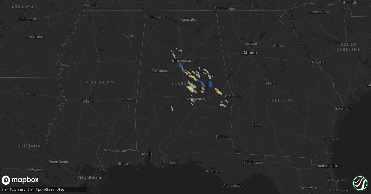
Hail Map in Alabama on August 11, 2023
Get this storm
August 11 map
$229
one time, instant access
Download today. No call, no setup
Keep the $229
Bought the map and want the full workflow? Apply the entire $229 to a subscription within 7 days. None of it is wasted.
Every map, not just this one
This buys you this map. Subscription and you get every map we run, in the markets you choose from a few cities to whole states to nationwide. Plus real-time alerts the moment a storm fires.
Contact data
Name, contact info, occupancy, even credit band for addresses in the footprint. You go from where it hit to who to call.
Become the source they trust
Unlimited branding weather history reports on demand. You already have the documented answer ready for the property owner, and you are the one who showed up with it.
Property data and RoofTrace estimates
Pull up any address you have got, its value and the exact code rules for that jurisdiction, straight from One Click Code. Then RoofTrace estimates the squares, pitch, and roof value, priced the way you price.
Storm reports in Alabama
Alabama
| Date | Description |
|---|---|
| 08/11/20236:58 PM CDT | Trees down on bryan road in sumiton. |
| 08/11/20235:40 PM CDT | Report of a covered porch blown off a home and several trees down. Also a workshop in the same area with roof damage. |
| 08/11/20234:30 PM CDT | Several tress down in brwons crossroads at the intersection of cr26 and cr53. |
| 08/11/20234:16 PM CDT | Tree down reported in the town of abbeville. |
| 08/11/20234:10 PM CDT | Corrects previous tstm wnd dmg report from 1 ssw wetumpka. Multiple trees down in and around wetumpka. |
| 08/11/20233:46 PM CDT | Trees were blown down and blocking the roadway. |
| 08/11/20233:20 PM CDT | A few trees were blown down. |
| 08/11/20232:57 PM CDT | Multiple trees uprooted... Power lines down... And outbuildings damaged throughout the tuskegee vicinity. |
| 08/11/20232:53 PM CDT | Tree down at highway 229 and atkins road. |
| 08/11/20232:53 PM CDT | Corrects previous tstm wnd dmg report from 4 sw martin dam. Multiple trees down along highway 229 between atkins road and martin dam road. |
| 08/11/20232:43 PM CDT | Powerline down on macedonia road. |
| 08/11/20232:33 PM CDT | Trees were blown down on highway 14 between elmers restaurant and cr 77. |
| 08/11/20232:24 PM CDT | Tree down at mariner road and real island road. |
| 08/11/20232:11 PM CDT | Multiple trees and power lines down near dadeville... Including madwind road and craddock road... North loop... And east lafayette street. |
| 08/11/20231:51 PM CDT | Tree down in roadway at timber trail and highway 22. |
| 08/11/20231:46 PM CDT | Multiple trees down in the new site area... Including cowpens west and lashley road. |
| 08/11/20231:32 PM CDT | Powerline down on lee road 11. |
| 08/11/20231:27 PM CDT | Trees and power lines down on north street. Sub-severe winds probable per radar. |
| 08/11/20231:04 PM CDT | Report from mping: quarter |
| 08/11/20231:01 PM CDT | Quarter-sized hail report from social media. Near the intersection on farmville road and conservation drive. |
| 08/11/20231:01 PM CDT | Several quarter-sized hail reports from social media. Occurring near auburn... Al. |
| 08/11/20237:05 AM CDT | Tree down blocking both lanes at rocksprings road and abbett road in jacksons gap. Time estimated from radar. |
| 08/10/20238:10 PM CDT | Trees down along county 42 near bullfrog lane and highway 70. |
| 08/10/20238:08 PM CDT | Multiple trees were blown down on highway 26. |
| 08/10/20238:06 PM CDT | Corrects previous tstm wnd dmg report from 2 ssw ballantrae. Multiple trees down in the saddle lake farms and weatherly neighborhoods... Some on homes. Trees down and p |
| 08/10/20238:00 PM CDT | Multiple trees down in the saddle lake farms and weatherly neighborhoods... Some on homes. |
| 08/10/20237:58 PM CDT | A couple trees down near shelby baptist. |
| 08/10/20237:55 PM CDT | Trees down on shamrock drive and bridlewood drive and county 95 in helena. |
| 08/10/20237:50 PM CDT | Tree down on buccaneer drive. |
| 08/10/20237:42 PM CDT | Several trees down on houses on maiden lane. Other trees down in bluff park. |
| 08/10/20237:42 PM CDT | Corrects previous tstm wnd dmg report from bluff park. Several trees down on houses on maiden lane and park terrace. Other trees down in bluff park and chapel road. |
| 08/10/20237:39 PM CDT | Trees down on valley street and shannon oxmoor road. |
| 08/10/20237:38 PM CDT | Trees down on lakeshore parkway and wenonah oxmoor road. |
All States Impacted by Hail Map on August 11, 2023
Cities Impacted by Hail Map on August 11, 2023
- Bellevue, TX
- Bowie, TX
- Prague, OK
- Sparks, OK
- Wataga, IL
- Cameron, IL
- Aledo, IL
- Henderson, IL
- Rio, IL
- North Henderson, IL
- Oneida, IL
- Alexis, IL
- Galesburg, IL
- Gilson, IL
- Elmwood, IL
- Knoxville, IL
- Victoria, IL
- Williamsfield, IL
- Dahinda, IL
- East Galesburg, IL
- Farmington, IL
- Hanna City, IL
- Manito, IL
- Trivoli, IL
- Mapleton, IL
- Kingston Mines, IL
- Fairview, IL
- Yates City, IL
- Peoria, IL
- Brimfield, IL
- Canton, IL
- Edwards, IL
- Maquon, IL
- Glasford, IL
- Norris, IL
- Abingdon, IL
- London Mills, IL
- East Peoria, IL
- Peoria Heights, IL
- Princeville, IL
- Creve Coeur, IL
- Dunlap, IL
- Pekin, IL
- Morton, IL
- Monmouth, IL
- Gerlaw, IL
- Groveland, IL
- Washington, IL
- Laura, IL
- Emden, IL
- Green Valley, IL
- Mackinaw, IL
- Armington, IL
- Minier, IL
- Delavan, IL
- South Pekin, IL
- Tremont, IL
- Hopedale, IL
- Hunnewell, MO
- Paris, MO
- Havana, IL
- Rushville, IL
- Moberly, MO
- Marshall, MO
- Centerview, MO
- Holden, MO
- Palmyra, MO
- Lewistown, IL
- Camp Point, IL
- Astoria, IL
- Higbee, MO
- Armstrong, MO
- Liberty, IL
- Quincy, IL
- Browning, IL
- Kingsville, MO
- Mount Sterling, IL
- Shelbina, MO
- Sweet Springs, MO
- Forest City, IL
- Topeka, IL
- Payson, IL
- Glasgow, MO
- Slater, MO
- Gilliam, MO
- Warrensburg, MO
- Holliday, MO
- Monroe City, MO
- Madison, MO
- Timewell, IL
- Huntsville, MO
- Hannibal, MO
- Concordia, MO
- Clayton, IL
- Warsaw, IL
- Logan, KS
- Fillmore, MO
- Saint Patrick, MO
- Spickard, MO
- Bremen, KS
- Colchester, IL
- Esbon, KS
- Table Grove, IL
- Seneca, KS
- Smithfield, IL
- Beattie, KS
- Craig, MO
- Forest City, MO
- Bethany, MO
- Falls City, NE
- Kirwin, KS
- Trenton, MO
- Guilford, MO
- Macomb, IL
- Glade, KS
- Formoso, KS
- Cuba, KS
- Mound City, MO
- Gorin, MO
- Mankato, KS
- Axtell, KS
- Washington, KS
- Gilman City, MO
- Galt, MO
- Pattonsburg, MO
- Cedar, KS
- Hamilton, IL
- Baileyville, KS
- Greentop, MO
- King City, MO
- Rea, MO
- Morrowville, KS
- Adair, IL
- Lenora, KS
- Rexford, KS
- Alexandria, MO
- Home, KS
- Kirksville, MO
- Memphis, MO
- Tennessee, IL
- Oketo, KS
- Gaylord, KS
- Hill City, KS
- Morland, KS
- Albany, MO
- Bolckow, MO
- Green City, MO
- Basco, IL
- Summerfield, KS
- Selden, KS
- Colby, KS
- McFall, MO
- Wyaconda, MO
- Kahoka, MO
- Du Bois, NE
- Maitland, MO
- Brashear, MO
- Oregon, MO
- Ipava, IL
- Baring, MO
- Marysville, KS
- Plymouth, IL
- Belleville, KS
- Scandia, KS
- Milan, MO
- Haddam, KS
- Phillipsburg, KS
- Green Castle, MO
- Courtland, KS
- Dawson, NE
- Bern, KS
- Hanover, KS
- Rutledge, MO
- Sabetha, KS
- Humboldt, NE
- Darlington, MO
- Salem, NE
- Liverpool, IL
- Novinger, MO
- Carthage, IL
- Edina, MO
- Rulo, NE
- Narka, KS
- Friend, NE
- Dorchester, NE
- Crete, NE
- Wilber, NE
- Western, NE
- De Witt, NE
- Beatrice, NE
- Pickrell, NE
- Filley, NE
- Auburn, AL
- Opelika, AL
- Waverly, AL
- Grapevine, AR
- Spearville, KS
- Alexander City, AL
- Carthage, AR
- Linn, KS
- Agenda, KS
- Greenleaf, KS
- Arkadelphia, AR
- Clyde, KS
- Clifton, KS
- Jacksons Gap, AL
- Dadeville, AL
- Palmer, KS
- Nauvoo, IL
- Morganville, KS
- Talladega, AL
- Ashland, AL
- Offerle, KS
- Poyen, AR
- Malvern, AR
- Sheridan, AR
- Leola, AR
- Ingalls, KS
- Camp Hill, AL
- Notasulga, AL
- Auburn University, AL
- Swanton, NE
- Milligan, NE
- Columbiana, AL
- Wilsonville, AL
- Amity, AR
- Blue Springs, NE
- Virginia, NE
- Liberty, NE
- Burchard, NE
- Pawnee City, NE
- Steinauer, NE
- Lewiston, NE
- Pillager, MN
- Motley, MN
- Fort Ripley, MN
- Brainerd, MN
- Baxter, MN
- Rockford, AL
- Sylacauga, AL
- Equality, AL
- Kellyton, AL
- Pierz, MN
- Hillman, MN
- Little Falls, MN
- Eclectic, AL
- Cook, NE
- Talmage, NE
- Brock, NE
- Ogilvie, MN
- Mora, MN
- Braham, MN
- Grasston, MN
- Stanchfield, MN
- Pine City, MN
- Onamia, MN
- Milaca, MN
- Rush City, MN
- Foley, MN
- Oak Park, MN
- Foreston, MN
- Princeton, MN
- Harris, MN
- Grantsburg, WI
- North Branch, MN
- Cambridge, MN
- Isanti, MN
- Blomkest, MN
- Lake Lillian, MN
- Saint Croix Falls, WI
- Elk River, MN
- Zimmerman, MN
- Stacy, MN
- Anoka, MN
- Cosmos, MN
- Cedar, MN
- Tyler, MN
- Balaton, MN
- Ruthton, MN
- Hector, MN
- Buffalo Lake, MN
- Buffalo, MN
- Waverly, MN
- Andover, MN
- Wyoming, MN
- Litchfield, MN
- Hutchinson, MN
- Darwin, MN
- Big Lake, MN
- Becker, MN
- Delano, MN
- Rockford, MN
- Loretto, MN
- Garvin, MN
- Stewart, MN
- Brownton, MN
- Glencoe, MN
- Cokato, MN
- Dassel, MN
- Silver Lake, MN
- Howard Lake, MN
- New Auburn, MN
- Arlington, MN
- Maple Lake, MN
- Green Isle, MN
- Hamel, MN
- Minneapolis, MN
- Long Lake, MN
- Wayzata, MN
- Watertown, MN
- Montrose, MN
- Currie, MN
- Westbrook, MN
- Storden, MN
- Jeffers, MN
- Hopkins, MN
- Maple Plain, MN
- Saint Paul, MN
- Henderson, MN
- Roberts, WI
- Hudson, WI
- Belle Plaine, MN
- Hammond, WI
- New Richmond, WI
- Wilson, WI
- Woodville, WI
- Glenwood City, WI
- Knapp, WI
- New Prague, MN
- Le Sueur, MN
- Le Center, MN
- Menomonie, WI
- South Saint Paul, MN
- Inver Grove Heights, MN
- Newport, MN
- Saint Paul Park, MN
- Mendota, MN
- Prescott, WI
- Hastings, MN
- Cottage Grove, MN
- River Falls, WI
- Afton, MN
- Beldenville, WI
- Hager City, WI
- Ellsworth, WI
- Elk Mound, WI
- Spring Valley, WI
- Eau Galle, WI
- Elmwood, WI
- Lakeland, MN
- Dallas, WI
- Clayton, WI
- Barron, WI
- Prairie Farm, WI
- Ridgeland, WI
- Chetek, WI
- New Auburn, WI
- Cleveland, MN
- Waterville, MN
- Kilkenny, MN
- Morristown, MN
- Bloomer, WI
- Wheeler, WI
- Chippewa Falls, WI
- Jim Falls, WI
- Cadott, WI
- Colfax, WI
- Windom, MN
- Mountain Lake, MN
- Bingham Lake, MN
- Butterfield, MN
- Boyd, WI
- Stanley, WI
- Thorp, WI
- Augusta, WI
- Mankato, MN
- Kasota, MN
- Elysian, MN
- Madison Lake, MN
- Saint Peter, MN
- Waseca, MN
- Janesville, MN
- Owatonna, MN
- Bay City, WI
- Warsaw, MN
- Faribault, MN
- Medford, MN
- Maiden Rock, WI
- Plum City, WI
- Stockholm, WI
- Arkansaw, WI
- Pepin, WI
- Owosso, MI
- Oakley, MI
- Chesaning, MI
- Greenwood, WI
- Withee, WI
- Owen, WI
- Willard, WI
- New Lothrop, MI
- Corunna, MI
- Claremont, MN
- Colby, WI
- Loyal, WI
- Curtiss, WI
- Unity, WI
- Spencer, WI
- Montgomery, MN
- Neillsville, WI
- Blooming Prairie, MN
- Fairmont, MN
- Pawhuska, OK
- Granada, MN
- Bartlesville, OK
- Nelson, WI
- Blue Earth, MN
- Dodge Center, MN
- Hayfield, MN
- Duke, OK
- Olustee, OK
- Elmer, OK
- Altus, OK
- Annandale, MN
- South Haven, MN
- Clearwater, MN
- Balsam Lake, WI
- Centuria, WI
- Rice, MN
- Sauk Rapids, MN
- Goodwater, AL
- Percival, IA
- Monticello, MN
- Saint Francis, MN
- Hackensack, MN
- Backus, MN
- Longville, MN
- Sheridan, MO
- Hallock, MN
- Montgomery, AL
- Walnut Grove, MN
- Detroit Lakes, MN
- Frazee, MN
- Perham, MN
- Baldwin, WI
- Kimball, MN
- Frederic, WI
- Siren, WI
- Marbury, AL
- Deatsville, AL
- Osseo, MN
- Champlin, MN
- Monroe, MI
- La Salle, MI
- Corinth, MS
- Rienzi, MS
- McRae Helena, GA
- Lumber City, GA
- Saint Helena Island, SC
- Saint Michael, MN
- Rogers, MN
- Wetumpka, AL
- Staples, MN
- Cushing, MN
- Tracy, MN
- Verbena, AL
- Prattville, AL
- Elmore, AL
- Morris, GA
- Coleman, GA
- Cuthbert, GA
- Shelby, AL
- Weogufka, AL
- Star Prairie, WI
- Arkansas City, KS
- Luck, WI
- Folly Beach, SC
- Forest Lake, MN
- Hurtsboro, AL
- Pittsview, AL
- Eufaula, AL
- Royalton, MN
- Calhoun, GA
- Gaylord, MN
- Bolivar, TN
- Newington, GA
- Audubon, MN
- Callaway, MN
- Hugo, MN
- Stillwater, MN
- Whiteville, TN
- Dexter, MI
- Chelsea, MI
- Ann Arbor, MI
- Childersburg, AL
- Center City, MN
- Dalton, GA
- Cushing, WI
- Deer Park, WI
- Dayton, MN
- Hatchechubbee, AL
- Winsted, MN
- Clay Center, KS
- Walnut, MS
- Seale, AL
- Lindstrom, MN
- Daviston, AL
- Titus, AL
- Fort Gaines, GA
- Bethel Springs, TN
- Finger, TN
- Georgetown, GA
- Lewis, KS
- Hilton Head Island, SC
- Kinsley, KS
- Somerville, TN
- Osceola, WI
- Bethel, MN
- Milltown, WI
- Turtle Lake, WI
- Adairsville, GA
- Henderson, TN
- Coolidge, GA
- Moultrie, GA
- Bluffton, GA
- Edison, GA
- Houlton, WI
- Somerset, WI
- Byers, KS
- Macksville, KS
- Haviland, KS
- Americus, GA
- Crystal, MI
- Carson City, MI
- Minnetonka, MN
- Johns Island, SC
- Charleston, SC
- Amery, WI
- Tallassee, AL
- Salem, AL
- Pike Road, AL
- Thomasville, GA
- Boston, GA
- Slayton, MN
- Milan, GA
- Jacksonville, GA
- Albertville, MN
- Elk City, OK
- Lake Elmo, MN
- Mayer, MN
- Prinsburg, MN
- Maple Grove, MN
- Hanover, MN
- Raymond, MN
- Nicollet, MN
- Mound, MN
- Niagara, ND
- Inkster, ND
- Cohutta, GA
- Cleveland, TN
- Chatsworth, GA
- Circle Pines, MN
- Shafer, MN
- Chisago City, MN
- Scandia, MN
- Felda, FL
- Canute, OK
- Butler, OK
- Clinton, OK
- Foss, OK
- Kasson, MN
- Elmore, MN
- Frost, MN
- Perry, MI
- Barnsdall, OK
- Ramona, OK
- Ochelata, OK
- Arapaho, OK
- Morrice, MI
- Granton, WI
- Chili, WI
- Marshfield, WI
- Alma, WI
- Durand, WI
- Nowata, OK
- Wabasha, MN
- Talala, OK
- Chelsea, OK
- Fountain City, WI
- Cochrane, WI
- Arcadia, WI
- Ettrick, WI
- Trempealeau, WI
- Galesville, WI
- Dodge, WI
- New York Mills, MN
- Oologah, OK
- Wadena, MN
- Deer Creek, MN
- Grand Meadow, MN
- Racine, MN
- Byron, MN
- Spring Valley, MN
- Stewartville, MN
- Waltham, MN
- Sargeant, MN
- Dexter, MN
- Bricelyn, MN
- Kiester, MN
- Claremore, OK
- Wells, MN
- Glenville, MN
- Conger, MN
- Twin Lakes, MN
- Albert Lea, MN
- Alden, MN
- Emmons, MN
- Weatherford, OK
- Custer City, OK
- Hayward, MN
- Lonsdale, MN
- Kenyon, MN
- West Concord, MN
- Austin, MN
- Holmen, WI
- Onalaska, WI
- La Crosse, WI
- Cannon Falls, MN
- Dennison, MN
- Goodhue, MN
- Zumbrota, MN
- Wanamingo, MN
- Thomas, OK
- Wykoff, MN
- Preston, MN
- Fenton, IA
- Armstrong, IA
- Lone Rock, IA
- Swea City, IA
- Bancroft, IA
- Burt, IA
- Titonka, IA
- Wesley, IA
- Lakota, IA
- Coon Valley, WI
- Sutherland, IA
- Peterson, IA
- Linn Grove, IA
- Auburndale, WI
- Mosinee, WI
- Stratford, WI
- Milladore, WI
- Junction City, WI
- Stevens Point, WI
- Plover, WI
- Taloga, OK
- Oakwood, OK
- Sioux Rapids, IA
- Stoddard, WI
- Chaseburg, WI
- Cashton, WI
- Westby, WI
- Viroqua, WI
- Britt, IA
- Corwith, IA
- Woden, IA
- Saint Ansgar, IA
- Osage, IA
- Little Cedar, IA
- Riceville, IA
- Webb, IA
- Stephenson, MI
- Wausaukee, WI
- Sturgeon Bay, WI
- Watonga, OK
- Geary, OK
- Greenfield, OK
- Canton, OK
- Fay, OK
- Omega, OK
- Okarche, OK
- Kingfisher, OK
- Hitchcock, OK
- Loyal, OK
- Curlew, IA
- Laurens, IA
- Ayrshire, IA
- Mallard, IA
- Havelock, IA
- Garner, IA
- Wallace, MI
- Porterfield, WI
- Menominee, MI
- Marinette, WI
- Red Wing, MN
- Klemme, IA
- Goodell, IA
- Meservey, IA
- Alexander, IA
- Thornton, IA
- Livermore, IA
- Bode, IA
- Ottosen, IA
- Dover, OK
- Cashion, OK
- Hennessey, OK
- Rolfe, IA
- West Bend, IA
- Lu Verne, IA
- Hardy, IA
- Renwick, IA
- Latimer, IA
- Swaledale, IA
- Sheffield, IA
- Hampton, IA
- Rockwell, IA
- Mason City, IA
- Dougherty, IA
- Marble Rock, IA
- Rockford, IA
- Greene, IA
- Kanawha, IA
- Clear Lake, IA
- Crescent, OK
- Gentry, MO
- Stanberry, MO
- Coffey, MO
- Jameson, MO
- Jamesport, MO
- Goldfield, IA
- Belmond, IA
- Clarion, IA
- Chapin, IA
- Aredale, IA
- Dumont, IA
- Holstein, IA
- Galva, IA
- Birmingham, AL
- Bessemer, AL
- Helena, AL
- Pelham, AL
- Calera, AL
- Alabaster, AL
- Schaller, IA
- Douglas, OK
- Covington, OK
- Fairmont, OK
- Garber, OK
- Perry, OK
- Lincoln, AR
- Summers, AR
- Canehill, AR
- Prairie Grove, AR
- West Fork, AR
- Chester, AR
- Mountainburg, AR
- Winslow, AR
- Billings, OK
- Red Rock, OK
- Odebolt, IA
- Early, IA
- Blue Mounds, WI
- Barneveld, WI
- Hollandale, WI
- Mount Horeb, WI
- Blanchardville, WI
- Dodgeville, WI
- Ridgeway, WI
- Monticello, WI
- New Glarus, WI
- Belleville, WI
- Prairie Du Chien, WI
- Chillicothe, MO
- Chula, MO
- New Hampton, MO
- Unionville, MO
- Worthington, MO
- Queen City, MO
- Albany, WI
- Mount Hope, WI
- Woodman, WI
- Mulberry, AR
- Alma, AR
- Wheeling, MO
- Linneus, MO
- Eagleville, MO
- Ridgeway, MO
- South Haven, KS
- Braman, OK
- Geuda Springs, KS
- Winfield, KS
- Meadville, MO
- Cainsville, MO
- Blythedale, MO
- Princeton, MO
- Denver, MO
- Grant City, MO
- Ozark, AR
- Dexter, KS
- Burden, KS
- Cambridge, KS
- Martinsville, MO
- Browning, MO
- Laredo, MO
- Humphreys, MO
- Burnsville, MS
- Counce, TN
- Michie, TN
- Rochester, MN
- Zumbro Falls, MN
- Plainview, MN
- Elgin, MN
- Millville, MN
- Saint James, MN
- Okeene, OK
- Granville, IA
- Paullina, IA
- Cleghorn, IA
- Ravenwood, MO
- Clyde, MO
- Redding, IA
- Blockton, IA
- Eldorado, OK
- Gould, OK
- Marathon, IA
- Eau Claire, WI
- Kellogg, MN
- Albion, MI
- Springport, MI
- Henderson, MI
- Kellerton, IA
- Mount Ayr, IA
- Georgiana, AL
- McKenzie, AL
- Leland, IA
- Forest City, IA
- Ventura, IA
- Fertile, IA
- Thompson, IA
- Dundas, MN
- Northfield, MN
- Empire, AL
- Bremen, AL
- Lake City, MN
- Lipscomb, TX
- Higgins, TX
- Crivitz, WI
- Elba, AL
- Marine On Saint Croix, MN
- Fall Creek, WI
- Wheeler, TX
- Mobeetie, TX
- Briscoe, TX
- Cleveland, WI
- Ceylon, MN
- Sherburn, MN
- Truman, MN
- Welcome, MN
- Winnebago, MN
- Lucien, OK
- Cordova, AL
- Jasper, AL
- Peshtigo, WI
- Mears, MI
- Clanton, AL
- Billingsley, AL
- Ringsted, IA
- Algona, IA
- Hope Hull, AL
- Letohatchee, AL
- Nerstrand, MN
- Welch, MN
- Quanah, TX
- Altoona, WI
- Ledyard, IA
- Hatfield, MO
- Joice, IA
- Buffalo Center, IA
- Alpine, AL
- Newkirk, OK
- Pembine, WI
- Daggett, MI
- Almena, WI
- Quinton, AL
- Adamsville, AL
- Dora, AL
- Hopkins, MO
- Bison, OK
- Waukomis, OK
- Mondovi, WI
- Downing, WI
- Excelsior, MN
- Waycross, GA
- Blackshear, GA
- Maryville, MO
- Trimont, MN
- Jemison, AL
- Paris, AR
- Altus, AR
- Reads Landing, MN
- Shidler, OK
- Millbrook, AL
- Rose Creek, MN
- Lyle, MN
- Egg Harbor, WI
- Brunswick, GA
- Spavinaw, OK
- Salina, OK
- Fulda, MN
- Evansville, AR
- Natural Dam, AR
- Mazeppa, MN
- Bovey, MN
- Arlington, GA
- Blakely, GA
- Twin Valley, MN
- La Crescent, MN
- Russellville, AL
- Waverly, GA
- Chelsea, AL
- Flushing, MI
- Pleasant Grove, AL
- Fairfield, AL
- Fayetteville, AR
- Farmington, AR
- Pine Island, MN
- Flint, MI
- Warrior, AL
- Mangum, OK
- Canton, OH
- Worth, MO
- Uvalda, GA
- Adair, OK
- Morrow, AR
- Frontenac, MN
- Eden Prairie, MN
- Bird Island, MN
- Manly, IA
- Kensett, IA
- Grafton, IA
- Purdin, MO
- Williamstown, MO
- Brookfield, MO
- Sutter, IL
- West Point, IL
- Laclede, MO
- Altura, MN
- Bowen, IL
- Marceline, MO
- Rothville, MO
- Keytesville, MO
- Salisbury, MO
- New Cambria, MO
- Mendon, MO
- Clifton Hill, MO
- Callao, MO
- Louisiana, MO
- Clarksville, MO
- Nebo, IL
- Clark, MO
- Sturgeon, MO
- Centralia, MO
- Hallsville, MO
- Bowling Green, MO
- Thompson, MO
- Mexico, MO
- Auxvasse, MO
- Martinsburg, MO
- Benton City, MO
- Laddonia, MO
- Rush Hill, MO
- Wellsville, MO
- Farber, MO
- Vandalia, MO
- Bellflower, MO
- Montgomery City, MO
- Middletown, MO
- Columbia, MO
- Curryville, MO
- Silex, MO
- Eolia, MO
- Hawk Point, MO
- Truxton, MO
- High Hill, MO
- Troy, MO
- Foristell, MO
- Elsberry, MO
- Moscow Mills, MO
- Wentzville, MO
- Wright City, MO
- Old Monroe, MO
- Foley, MO
- Winfield, MO
- Brussels, IL
- Golden Eagle, IL
- O'Fallon, MO
- Lake Saint Louis, MO
- Saint Charles, MO
- Saint Peters, MO
- Saint Louis, MO
- Chesterfield, MO
- Florissant, MO
- Bridgeton, MO
- Maryland Heights, MO
- Hazelwood, MO
- Saint Ann, MO
- Earth City, MO
- Anabel, MO
- Clarence, MO
- Sarcoxie, MO
- Gallatin, MO
- Ethel, MO
- Conway Springs, KS
- Milton, KS
- East Canton, OH
- Fieldon, IL
- Jerseyville, IL
- Hardin, IL
- Harpers Ferry, IA
- McGregor, IA
- Monona, IA
- Norwich, KS
- Clarks Grove, MN
- Hollandale, MN
- Harris, MO
- New London, MO
- Center, MO
- Spivey, KS
- Frankford, MO
- McCune, KS
- Hamburg, IL
- Lentner, MO
- Wright, KS
- Novelty, MO
- Ada, MI
- Lowell, MI
- Arena, WI
- Spring Green, WI
- Macon, MO
- Bevier, MO
- Waukon, IA
- Dorchester, IA
- Lansing, IA
- Pawnee, IL
- Auburn, IL
- Chatham, IL
- Glenarm, IL
- Divernon, IL
- Newtown, MO
- Bethel, MO
- Philadelphia, MO
- Emden, MO
- Hurdland, MO
- Heyworth, IL
- Shirley, IL
- McLean, IL
- Verona, WI
- Leon, KS
- Knox City, MO
- Monticello, MO
- La Belle, MO
- Canton, MO
- Lock Springs, MO
- Wauzeka, WI
- Waterville, IA
- Luana, IA
- Rockport, IL
- Blue River, WI
- Muscoda, WI
- Rosemount, MN
- Garden City, KS
- Eagle Lake, MN
- Winigan, MO
- Altoona, KS
- Thayer, KS
- Neodesha, KS
- Galesburg, KS
- Chanute, KS
- Augusta, IL
- Keokuk, IA
- Elvaston, IL
- Shelby, MI
- Gays Mills, WI
- Richland Center, WI
- Soldiers Grove, WI
- Avoca, WI
- Lone Rock, WI
- Minter, AL
- Camden, AL
- Parsons, KS
- Ashburn, MO
- Saint Paul, KS
- Walnut, KS
- Girard, KS
- Plover, IA
- Joplin, MO
- Novi, MI
- Bedford, IA
- Parnell, MO
- Ewing, MO
- Wellington, KS
- Stacyville, IA
- Bristow, IA
- Maywood, MO
- Shelbyville, MO
- Durham, MO
- Newark, MO
- Bucklin, KS
- Greensburg, KS
- Augusta, KS
- Morrison, OK
- Fredonia, KS
- Bucklin, MO
- Lockwood, MO
- Golden City, MO
- Pollock, MO
- Ormsby, MN
- Thorsby, AL
- New Boston, MO
- Humboldt, KS
- Pittsburg, KS
- Arma, KS
- Franklin, KS
- Nora Springs, IA
- Stilwell, OK
- Eureka, MO
- Wildwood, MO
- Ballwin, MO
- Valley Park, MO
- Pacific, MO
- High Ridge, MO
- House Springs, MO
- Arnold, MO
- Imperial, MO
- Fenton, MO
- Barnhart, MO
- Utica, MO
- Mindenmines, MO
- Coatesville, IN
- Lamar, MO
- Liberal, MO
- Decorah, IA
- Fall River, KS
- Sullivan, MO
- Gifford, IL
- Potomac, IL
- Rankin, IL
- Thomasboro, IL
- Penfield, IL
- Hoopeston, IL
- Rantoul, IL
- Rossville, IL
- Bismarck, IL
- Danville, IL
- Alvin, IL
- Paxton, IL
- Loda, IL
- Melvin, IL
- Brunswick, MO
- Dalton, MO
- Le Roy, MN
- Taopi, MN
- Bicknell, IN
- Edwardsport, IN
- Carlisle, IN
- Freelandville, IN
- Oaktown, IN
- Stover, MO
- Cole Camp, MO
- Edwardsville, IL
- Glen Carbon, IL
- Rocheport, MO
- Fulton, MO
- Warrenton, MO
- Godfrey, IL
- Dow, IL
- Monrovia, IN
- Martinsville, IN
- Clayton, IN
- Mooresville, IN
- Bainbridge, IN
- Fillmore, IN
- Carbon, IN
- Bridgeton, IN
- Rosedale, IN
- Rockville, IN
- Harrisburg, MO
- Fayette, MO
- Beaufort, MO
- Mansfield, IL
- Bethalto, IL
- Savonburg, KS
- Elsmore, KS
- Lees Summit, MO
- Grain Valley, MO
- Raymore, MO
- Lone Jack, MO
- Pleasant Hill, MO
- Overland Park, KS
- Belton, MO
- Greenwood, MO
- Kansas City, MO
- Stilwell, KS
- Grandview, MO
- Gibson City, IL
- Ludlow, IL
- Elliott, IL
- Greencastle, IN
- Gravois Mills, MO
- Sandborn, IN
- La Harpe, KS
- Sumner, MO
- Moran, KS
- Chandlerville, IL
- Bath, IL
- Frederick, IL
- Beardstown, IL
- Alhambra, IL
- Marine, IL
- Grafton, IL
- Versailles, MO
- Bloomington, IL
- Stanford, IL
- Le Roy, IL
- Downs, IL
- Erie, KS
- Grand Tower, IL
- Mora, MO
- Reeds, MO
- Gerald, MO
- New Haven, MO
- Rocky Mount, MO
- Union, MO
- Covington, IN
- Adams, MN
- Eldon, MO
- Veedersburg, IN
- Williamsport, IN
- East Alton, IL
- Alton, IL
- Cottage Hills, IL
- Moro, IL
- Brighton, IL
- Kingman, KS
- Potosi, MO
- Altamont, MO
- Montezuma, IN
- Mecca, IN
- Hillsdale, IN
- Carlinville, IL
- Greenfield, IL
- Hettick, IL
- Chesterfield, IL
- Colony, KS
- Kincaid, KS
- Welda, KS
- Leslie, MO
- Rosebud, MO
- Owensville, MO
- Ionia, MO
- Sedalia, MO
- Lincoln, MO
- Green Ridge, MO
- Mulberry, KS
- Waynetown, IN
- Allison, IA
- Iola, KS
- Carthage, MO
- Benedict, KS


