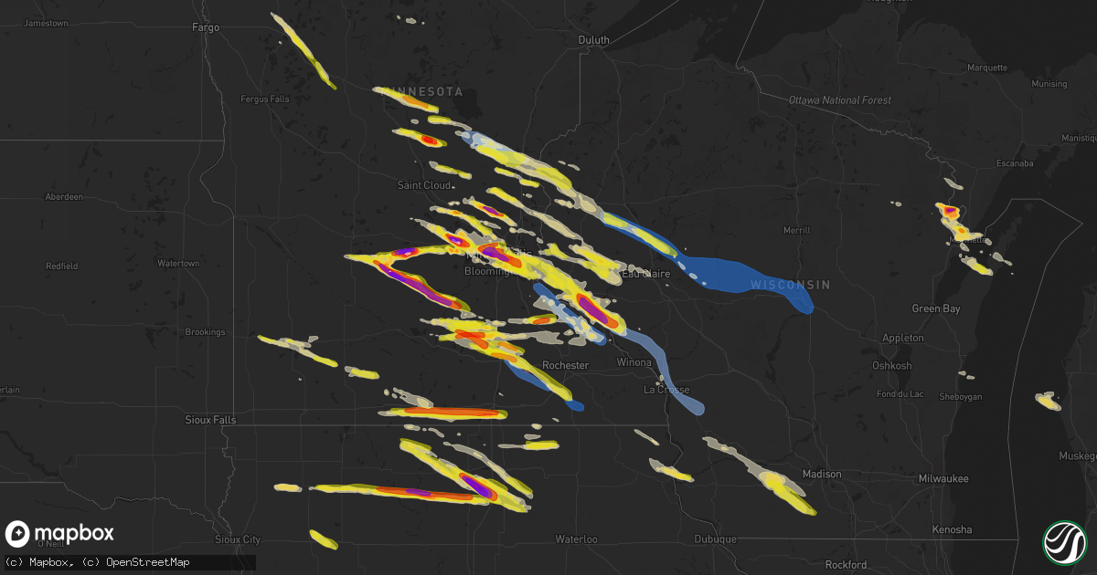
Hail Map on August 11, 2023
Get this storm
August 11 map
$229
one time, instant access
Download today. No call, no setup
Keep the $229
Bought the map and want the full workflow? Apply the entire $229 to a subscription within 7 days. None of it is wasted.
Every map, not just this one
This buys you this map. Subscription and you get every map we run, in the markets you choose from a few cities to whole states to nationwide. Plus real-time alerts the moment a storm fires.
Contact data
Name, contact info, occupancy, even credit band for addresses in the footprint. You go from where it hit to who to call.
Become the source they trust
Unlimited branding weather history reports on demand. You already have the documented answer ready for the property owner, and you are the one who showed up with it.
Property data and RoofTrace estimates
Pull up any address you have got, its value and the exact code rules for that jurisdiction, straight from One Click Code. Then RoofTrace estimates the squares, pitch, and roof value, priced the way you price.
States Impacted by Hail Map on August 11, 2023
Storm reports
Arkansas
| Date | Description |
|---|---|
| 08/11/20237:45 AM CDT | Multiple trees down along highway 46 between prattsville and leola. |
| 08/10/202311:07 PM CDT | Trees down on highway 64. |
| 08/10/202310:55 PM CDT | Damaged power pole at 2307 bugscuffle rd. |
| 08/10/202310:50 PM CDT | Report via social media. |
| 08/10/202310:18 PM CDT | A local report indicates 70 MPH wind near Chester |
| 08/10/20239:50 PM CDT | Power lines down on road. Report via social media. |
Tennessee
| Date | Description |
|---|---|
| 08/11/20234:46 PM CDT | Trees and powerlines down on james road in bolivar. |
| 08/11/20234:46 PM CDT | Trees and powerlines down on mecklenburg drive in bolivar. |
Georgia
| Date | Description |
|---|---|
| 08/11/20234:20 PM CDT | Large tree limbs were blown down onto on sr 266 eastbound at cotton hill road and blocked 1 lane. |
| 08/11/20234:09 PM CDT | Trees reported down across randolph county. |
| 08/10/20238:10 PM CDT | Report of tree down caused by thunderstorm winds. |
| 08/10/20237:40 PM CDT | Report of tree down caused by thunderstorm winds. |
| 08/10/20237:30 PM CDT | Delayed report of tree down across rail road tracks caused by thunderstorm winds. |
Illinois
| Date | Description |
|---|---|
| 08/11/20239:15 AM CDT | Report of a couple trees down...estimated winds of 45 mph. |
| 08/11/20238:28 AM CDT | Four power poles down on woodlawn road. |
| 08/11/20237:45 AM CDT | Report of a tree uprooted at 14th and willow in pekin. |
| 08/11/20237:35 AM CDT | A local report indicates 63 MPH wind near Bellevue |
| 08/11/20237:30 AM CDT | Considerable damage due to high winds at wildlife prairie park with trees blown down and damage to vehicles. Some localized flooding due to heavy rains. |
| 08/11/20237:20 AM CDT | Estimated winds of at least 60mph. |
| 08/11/20237:15 AM CDT | Report of power lines down. |
| 08/11/20237:15 AM CDT | Large tree split and downed over a road in the city. Relayed by news media. |
| 08/11/20237:05 AM CDT | Uprooted tree has fallen onto the maquon district public library. |
| 08/11/20232:03 AM CDT | Power lines down. Time is approximate. |
| 08/11/20232:03 AM CDT | Tree down over a road in pleasant hill. Time estimated from radar. |
| 08/11/20232:00 AM CDT | Report of a tree down in summer hill... Il. Time is approximate. |
| 08/11/20231:57 AM CDT | Tree down northeast of atlas... Il on route 54. Time is approximate. |
| 08/11/202312:05 AM CDT | Two trees and a fence downed at a residence in antioch. Time estimated from radar. |
| 08/10/202311:50 PM CDT | Tree downed onto doty rd. At lucas rd. Time estimated from radar. |
| 08/10/202311:41 PM CDT | Photo shared on social media showed damage to exterior fascia of roof on a home. Small tree limbs were also reported downed in the area. Time estimated by radar. |
| 08/10/202311:28 PM CDT | Photo shared on social media showing half of a small tree snapped in poplar grove. |
| 08/10/202311:27 PM CDT | Several trees downed along the long prairie trail in boone county. Time estimated from radar. |
Oklahoma
| Date | Description |
|---|---|
| 08/11/20236:55 PM CDT | Butler |
| 08/11/20236:45 PM CDT | Report of numerous power poles blown down and sporadic roof damage across elk city. Time estimated via radar. |
| 08/11/20236:45 PM CDT | Report of trees blown down. Time estimated via radar. |
| 08/11/20236:15 PM CDT | A local report indicates 74 MPH wind near 8 ESE Foraker |
| 08/11/20235:35 PM CDT | A local report indicates 61 MPH wind near 4 WNW Gould |
| 08/10/20239:20 PM CDT | Altus |
| 08/10/20239:16 PM CDT | Klts. |
| 08/10/20239:15 PM CDT | Social media image showing a large |
| 08/10/20238:40 PM CDT | Report of trees down in southern portions of altus. |
| 08/10/20238:35 PM CDT | Kjwg. |
| 08/10/20238:25 PM CDT | Watonga |
| 08/10/20237:05 PM CDT | Butler |
| 08/10/20237:00 PM CDT | Butler |
Missouri
| Date | Description |
|---|---|
| 08/11/20235:09 AM CDT | 6in tree limbs snapped from several trees. Report via twitter. |
| 08/11/20234:50 AM CDT | Power lines down along schoetler valley drive. Time estimated from radar. |
| 08/11/20234:43 AM CDT | A local report indicates 60 MPH wind near 1 WNW Cottleville |
| 08/11/20234:38 AM CDT | A local report indicates 60 MPH wind near Saint Peters |
| 08/11/20234:37 AM CDT | Large tree branch blown down onto house causing minor roof... Soffit and gutter damage. Via twitter with picture. |
| 08/11/20234:35 AM CDT | A large tree blown down. Also... A large tree limb was snapped off landing on a vinyl fence damaging it. Via twitter with pictures. |
| 08/11/20234:25 AM CDT | Large pine tree snapped off about halfway up trunk. Via facebook with picture. |
| 08/11/20234:20 AM CDT | Several large tree limbs snapped off around the neighborhood as well as minor shingle damage to a few roofs. |
| 08/11/20234:17 AM CDT | Power poles down. |
| 08/11/20234:15 AM CDT | Several trees blown down. Via facebook post with pictures. |
| 08/11/20234:12 AM CDT | Trees down in the city. |
| 08/11/20234:05 AM CDT | Open sided pole barn shifted off foundation with part of end wall blown out. Via facebook post with picture. |
| 08/11/20234:03 AM CDT | Report relayed from a viewer of trees down in troy... Mo. |
| 08/11/20233:45 AM CDT | Tree limbs down on powerlines in greenfield. |
| 08/11/20233:40 AM CDT | Numerous large maple trees sustained damage with one tree blown over and another one was split in half. |
| 08/11/20233:40 AM CDT | Large tree branches down on roadway. |
| 08/11/20233:35 AM CDT | Tree limbs down on powerlines in lockwood. |
| 08/11/20233:16 AM CDT | Measured at kmyj. |
| 08/11/20232:40 AM CDT | Large trees covering roadways in bowling green. |
| 08/11/20231:17 AM CDT | 10inch diameter tree has fallen. Location is approximate on new street. Time is approximate. |
| 08/11/20231:15 AM CDT | Widespread damage on a farm. Two thirds of a large barn buckled up with i beams bowed in. Also... A garage was destroyed. Several trees blown down. |
| 08/11/202312:54 AM CDT | Wind driven hail caused damage to siding. |
| 08/11/202312:54 AM CDT | Large tree limbs downed. |
| 08/10/202311:50 PM CDT | Reported on highway 65. |
| 08/10/202310:18 PM CDT | A local report indicates 1.50 inch wind near Mcfall |
| 08/10/202310:15 PM CDT | A local report indicates 1.00 inch wind near 6 SW Trenton |
| 08/10/20239:33 PM CDT | A local report indicates 1.75 inch wind near 6 W Gentry |
Minnesota
| Date | Description |
|---|---|
| 08/11/20236:58 PM CDT | Corrects time of previous tstm wnd dmg report from claremont. Grain elevator/bin sustained considerable damage from strong winds. |
| 08/11/20236:50 PM CDT | Off duty park ranger reported dime to quarter sized hail. Power is out and many trees are down in area. |
| 08/11/20236:48 PM CDT | Several tree limbs down near the mississippi river. |
| 08/11/20236:40 PM CDT | A local report indicates 1.25 inch wind near 2 W Faribault |
| 08/11/20236:40 PM CDT | Reported via ham in nwschat. |
| 08/11/20236:36 PM CDT | A local report indicates 1.00 inch wind near 3 E Deer Creek |
| 08/11/20236:31 PM CDT | Reported via ham in nwschat. |
| 08/11/20236:25 PM CDT | 4 inch branch down... Reported via ham in nwschat. |
| 08/11/20236:20 PM CDT | Various trees and branches down in and around kenyon... Reported via ham in nwschat. Time estimated. |
| 08/11/20236:20 PM CDT | Relayed via broadcast media from public. Time estimated from radar. |
| 08/11/20236:16 PM CDT | A local report indicates 1.75 inch wind near Morristown |
| 08/11/20236:08 PM CDT | Relayed via broadcast media. Report from public. |
| 08/11/20236:03 PM CDT | Trees uprooted. Report states trees down everywhere. Time estimated from radar. Relayed from broadcast media. |
| 08/11/20236:02 PM CDT | A local report indicates 1.75 inch wind near 2 E Waterville |
| 08/11/20235:56 PM CDT | A local report indicates 1.25 inch wind near 1 WSW South St. Paul |
| 08/11/20235:54 PM CDT | Report from mping: quarter |
| 08/11/20235:54 PM CDT | Power lines were reported down in st. James. |
| 08/11/20235:52 PM CDT | Picture via twitter. |
| 08/11/20235:50 PM CDT | Picture next to baseball... Slightly smaller... Via twitter. |
| 08/11/20235:50 PM CDT | Up to half dollar hail reported by off duty nws employee at msp airport. |
| 08/11/20235:49 PM CDT | Asos station kstp st. Paul dwtn ap. |
| 08/11/20235:47 PM CDT | Picture via twitter. |
| 08/11/20235:44 PM CDT | Picture via twitter. |
| 08/11/20235:43 PM CDT | Picture via twitter. |
| 08/11/20235:41 PM CDT | A local report indicates 1.25 inch wind near 3 SW St. Paul |
| 08/11/20235:40 PM CDT | A local report indicates 1.00 inch wind near 1 N West St. Paul |
| 08/11/20235:37 PM CDT | Report from mping: hen egg |
| 08/11/20235:36 PM CDT | Picture via twitter. |
| 08/11/20235:36 PM CDT | Large trees uprooted... Home fence knocked over. Pictures via facebook messenger. Time estimated via radar. |
| 08/11/20235:35 PM CDT | Picture via twitter. |
| 08/11/20235:35 PM CDT | A local report indicates 1.25 inch wind near 1 SSE Minneapolis |
| 08/11/20235:33 PM CDT | A local report indicates 1.75 inch wind near 2 SW Minneapolis |
| 08/11/20235:32 PM CDT | Picture via twitter. |
| 08/11/20235:32 PM CDT | Report from mping: quarter |
| 08/11/20235:32 PM CDT | Report from mping: ping pong ball |
| 08/11/20235:31 PM CDT | Power also reported out in odin. |
| 08/11/20235:30 PM CDT | A local report indicates 1.75 inch wind near 2 NNW Mendota Heights |
| 08/11/20235:29 PM CDT | A local report indicates 1.50 inch wind near 6 N Henderson |
| 08/11/20235:28 PM CDT | A local report indicates 1.50 inch wind near 3 SSE Minneapolis |
| 08/11/20235:27 PM CDT | Picture via twitter. |
| 08/11/20235:24 PM CDT | A local report indicates 2.50 inch wind near 2 WNW Minneapolis |
| 08/11/20235:23 PM CDT | Reported via facebook messenger. |
| 08/11/20235:23 PM CDT | Report from mping: ping pong ball |
| 08/11/20235:23 PM CDT | Picture with tape measure via twitter. |
| 08/11/20235:22 PM CDT | A local report indicates 1.50 inch wind near 1 SSE Robbinsdale |
| 08/11/20235:21 PM CDT | A local report indicates 1.75 inch wind near 1 ESE Robbinsdale |
| 08/11/20235:20 PM CDT | Slightly larger than 2 inch hail reported via twitter. |
| 08/11/20235:20 PM CDT | A local report indicates 1.50 inch wind near Plymouth |
| 08/11/20235:19 PM CDT | A local report indicates 1.75 inch wind near 2 S Minneapolis |
| 08/11/20235:18 PM CDT | Picture via facebook comments... Time estimated via radar. |
| 08/11/20235:16 PM CDT | Picture via twitter. |
| 08/11/20235:10 PM CDT | Relayed via nwschat. |
| 08/11/20235:10 PM CDT | A local report indicates 1.00 inch wind near Watertown |
| 08/11/20235:08 PM CDT | A local report indicates 1.00 inch wind near Arlington |
| 08/11/20235:04 PM CDT | Picture via twitter. |
| 08/11/20234:58 PM CDT | A local report indicates 1.00 inch wind near 4 S Maple Lake |
| 08/11/20234:50 PM CDT | Picture with ruler via facebook messenger. Slightly larger than 3 inches. |
| 08/11/20234:49 PM CDT | Picture with ruler on twitter. |
| 08/11/20234:48 PM CDT | Hail measured 3.75 inches in diameter near hwy 15. Submitted photo of hail with ruler via email. Damage to siding on west side of house. |
| 08/11/20234:48 PM CDT | Mostly pea sized but a few up to quarter sized stones. |
| 08/11/20234:46 PM CDT | Hail up to 1.5 inches in rockford relayed via nwschat. |
| 08/11/20234:46 PM CDT | Picture via facebook comments. |
| 08/11/20234:45 PM CDT | Reported via nwschat. |
| 08/11/20234:35 PM CDT | Delayed report via facebook messenger. |
| 08/11/20234:33 PM CDT | Delayed report of baseball size hail at the oakdale golf course. Cars dented and windows shattered. |
| 08/11/20234:28 PM CDT | Estimated up to baseball sized hail north of buffalo lake near lake allie. Time estimated by radar and sized estimated via pictures on twitter. |
| 08/11/20234:27 PM CDT | Report from mping: ping pong ball |
| 08/11/20234:19 PM CDT | Pea size transitioned to quarter sized hail after initial call. |
| 08/11/20234:17 PM CDT | Relayed to nws via facebook message. |
| 08/11/20234:16 PM CDT | Corrects previous hail report from 3 sw st. Francis. Mostly quarter to half dollar with a few stones up to 2 inches. |
| 08/11/20234:13 PM CDT | 4 to 6 inch branches and trees down in center city. |
| 08/11/20234:10 PM CDT | Relayed via facebook messenger. |
| 08/11/20234:09 PM CDT | A coop observer reported quarter sized hail 8 miles west of tracy. The time was estimated via radar. |
| 08/11/20233:57 PM CDT | A local report indicates 1.00 inch wind near 3 ESE Harris |
| 08/11/20233:41 PM CDT | 4 to 6 inch tree branches are down. Power flickering on and off. |
| 08/11/20233:40 PM CDT | 6 to 8 inch diameter tree fell... Crushing a canvas tent. Time estimated from radar. |
| 08/11/20233:20 PM CDT | Report relayed from nws duluth on facebook. |
| 08/11/20233:17 PM CDT | Awos station kjmr mora ap. |
| 08/11/20233:15 PM CDT | Trained spotters relayed via ham scattered branches up to 6 inches in diameter down around mora. |
| 08/11/20233:15 PM CDT | A local report indicates 1.00 inch wind near 5 S Mora |
| 08/11/20233:11 PM CDT | Delayed report. Received photos of a large tree snapped |
| 08/11/20232:56 PM CDT | 12 to 14 inch oak tree branch down in yard. Relayed via ham in nwschat. |
| 08/11/20232:56 PM CDT | Delayed report via nwschat... 22 inch diameter branch down reported by trained spotter. |
| 08/11/20232:46 PM CDT | 2 to 2.25 inch hail in pierz relayed via ham in nwschat. |
| 08/11/20232:28 PM CDT | 3-4 inch limbs broken relayed via ham on nwschat. |
| 08/11/20232:22 PM CDT | Just under golf ball sized hail reported near harding by trained spotter. |
| 08/11/20232:11 PM CDT | One oak tree snapped that was at least 12 inches in diameter. A pine tree was also severely pushed to one side with some trees also pushed that direction in the area. |
| 08/11/20232:09 PM CDT | Few branches down tho not big and pea size hail reported. |
| 08/10/20238:00 PM CDT | Delayed report... Wind gusts of 65 to 70mph. |
| 08/10/20237:58 PM CDT | Grain elevator/bin sustained considerable damage from strong winds. |
| 08/10/20237:42 PM CDT | A local report indicates 1.75 inch wind near 2 SW Albert Lea |
| 08/10/20237:40 PM CDT | A local report indicates 1.00 inch wind near 2 W Albert Lea |
| 08/10/20237:33 PM CDT | Tree down on highway 14. |
| 08/10/20237:15 PM CDT | A local report indicates 1.00 inch wind near High Forest |
| 08/10/20237:08 PM CDT | Grain bin flattened - time estimated by radar. |
| 08/10/20237:05 PM CDT | Picture via twitter. |
| 08/10/20237:05 PM CDT | Social media picture of large tree limb down between claremont and dodge center. |
Alabama
| Date | Description |
|---|---|
| 08/11/20236:58 PM CDT | Trees down on bryan road in sumiton. |
| 08/11/20235:40 PM CDT | Report of a covered porch blown off a home and several trees down. Also a workshop in the same area with roof damage. |
| 08/11/20234:30 PM CDT | Several tress down in brwons crossroads at the intersection of cr26 and cr53. |
| 08/11/20234:16 PM CDT | Tree down reported in the town of abbeville. |
| 08/11/20234:10 PM CDT | Corrects previous tstm wnd dmg report from 1 ssw wetumpka. Multiple trees down in and around wetumpka. |
| 08/11/20233:46 PM CDT | Trees were blown down and blocking the roadway. |
| 08/11/20233:20 PM CDT | A few trees were blown down. |
| 08/11/20232:57 PM CDT | Multiple trees uprooted... Power lines down... And outbuildings damaged throughout the tuskegee vicinity. |
| 08/11/20232:53 PM CDT | Tree down at highway 229 and atkins road. |
| 08/11/20232:53 PM CDT | Corrects previous tstm wnd dmg report from 4 sw martin dam. Multiple trees down along highway 229 between atkins road and martin dam road. |
| 08/11/20232:43 PM CDT | Powerline down on macedonia road. |
| 08/11/20232:33 PM CDT | Trees were blown down on highway 14 between elmers restaurant and cr 77. |
| 08/11/20232:24 PM CDT | Tree down at mariner road and real island road. |
| 08/11/20232:11 PM CDT | Multiple trees and power lines down near dadeville... Including madwind road and craddock road... North loop... And east lafayette street. |
| 08/11/20231:51 PM CDT | Tree down in roadway at timber trail and highway 22. |
| 08/11/20231:46 PM CDT | Multiple trees down in the new site area... Including cowpens west and lashley road. |
| 08/11/20231:32 PM CDT | Powerline down on lee road 11. |
| 08/11/20231:27 PM CDT | Trees and power lines down on north street. Sub-severe winds probable per radar. |
| 08/11/20231:04 PM CDT | Report from mping: quarter |
| 08/11/20231:01 PM CDT | Quarter-sized hail report from social media. Near the intersection on farmville road and conservation drive. |
| 08/11/20231:01 PM CDT | Several quarter-sized hail reports from social media. Occurring near auburn... Al. |
| 08/11/20237:05 AM CDT | Tree down blocking both lanes at rocksprings road and abbett road in jacksons gap. Time estimated from radar. |
| 08/10/20238:10 PM CDT | Trees down along county 42 near bullfrog lane and highway 70. |
| 08/10/20238:08 PM CDT | Multiple trees were blown down on highway 26. |
| 08/10/20238:06 PM CDT | Corrects previous tstm wnd dmg report from 2 ssw ballantrae. Multiple trees down in the saddle lake farms and weatherly neighborhoods... Some on homes. Trees down and p |
| 08/10/20238:00 PM CDT | Multiple trees down in the saddle lake farms and weatherly neighborhoods... Some on homes. |
| 08/10/20237:58 PM CDT | A couple trees down near shelby baptist. |
| 08/10/20237:55 PM CDT | Trees down on shamrock drive and bridlewood drive and county 95 in helena. |
| 08/10/20237:50 PM CDT | Tree down on buccaneer drive. |
| 08/10/20237:42 PM CDT | Several trees down on houses on maiden lane. Other trees down in bluff park. |
| 08/10/20237:42 PM CDT | Corrects previous tstm wnd dmg report from bluff park. Several trees down on houses on maiden lane and park terrace. Other trees down in bluff park and chapel road. |
| 08/10/20237:39 PM CDT | Trees down on valley street and shannon oxmoor road. |
| 08/10/20237:38 PM CDT | Trees down on lakeshore parkway and wenonah oxmoor road. |
Wisconsin
| Date | Description |
|---|---|
| 08/11/20236:54 PM CDT | Report forwarded by wbay-tv. Time estimated from radar. |
| 08/11/20236:53 PM CDT | A local report indicates 1.00 inch wind near 1 N Loyal |
| 08/11/20236:47 PM CDT | A local report indicates 70 MPH wind near Loyal |
| 08/11/20236:40 PM CDT | Delayed report up to golf ball sized hail. Picture via twitter. |
| 08/11/20236:40 PM CDT | Picture via broadcast media on twitter. Size estimated based on picture between 2 and 2.5 inches. |
| 08/11/20236:33 PM CDT | A local report indicates 60 MPH wind near Longwood |
| 08/11/20236:30 PM CDT | Estimated hail up to 2 inches... Relayed via broadcast media through nwschat. |
| 08/11/20236:20 PM CDT | A local report indicates 1.25 inch wind near 4 NNW Bay City |
| 08/11/20236:09 PM CDT | A local report indicates 1.00 inch wind near 4 N Cadott |
| 08/11/20236:03 PM CDT | Small trees down. |
| 08/11/20235:42 PM CDT | A local report indicates 1.00 inch wind near 3 W Menomonie |
| 08/11/20235:33 PM CDT | A local report indicates 1.25 inch wind near 1 E Knapp |
| 08/11/20235:30 PM CDT | A few medium to large trees down and large branches snapped... Pictures via facebook comments. Also up to nickel sized hail. |
| 08/11/20235:30 PM CDT | Corrects previous tstm wnd dmg report from bloomer. A few medium to large trees down and large branches snapped... Pictures via facebook comments. Also up to nickel siz |
| 08/11/20235:17 PM CDT | A local report indicates 1.00 inch wind near 4 ENE Hudson |
| 08/11/20234:30 PM CDT | Tree down on power line... Size unknown. |
| 08/11/20233:55 PM CDT | Power pole snapped from winds. |
| 08/11/20233:55 PM CDT | Mentioned a few quarter sized hail. |
| 08/10/202310:47 PM CDT | Delayed report. Large tree branch down on a car. A few other large tree branches down. Time estimated from radar. |
| 08/10/202310:45 PM CDT | A local report indicates 1.00 inch wind near 1 E Albany |
| 08/10/20239:08 PM CDT | Richland county sheriffs office reported tree down blocking the road. Time estimated via radar. |
| 08/10/20239:00 PM CDT | Trees downed. Time estimated from radar. |
| 08/10/20238:55 PM CDT | 50mph winds reported with power outages in ripon. |
| 08/10/20238:54 PM CDT | Multiple trees and wires down. |
| 08/10/20238:40 PM CDT | Trempealeau sheriffs office reported trees down on county road k. Time estimated via radar. |
| 08/10/20238:24 PM CDT | Multiple reports of many power lines down and loss of power. Time estimated via radar. |
| 08/10/20238:23 PM CDT | Most damage 60 to 70 mph with isolated peaks to 80 mph with larger snapped maple trees. Time estimated via radar. |
| 08/10/20238:20 PM CDT | Delayed report. Trees down northwest of big falls. The time of this report is an estimate based on radar data. |
| 08/10/20238:05 PM CDT | Buffalo cty sheriffs office passed along power line down. |
| 08/10/20238:05 PM CDT | Report from mping: 1-inch tree limbs broken; shingles blown off. |
| 08/10/20238:04 PM CDT | La crosse county sheriffs office reported tree |
| 08/10/20238:01 PM CDT | La crosse county sheriffs office reported 8 trees down within the city of la crosse. Time estimated via radar. |
| 08/10/20238:01 PM CDT | Asos station klse la crosse regional airport. |
| 08/10/20237:56 PM CDT | A local report indicates 60 MPH wind near Onalaska |
| 08/10/20237:55 PM CDT | Report from mping: 3-inch tree limbs broken; power poles broken. |
| 08/10/20237:46 PM CDT | Measured at coop station plow3. |
| 08/10/20237:43 PM CDT | Report from mping: 3-inch tree limbs broken; power poles broken. |
| 08/10/20237:41 PM CDT | Large tree blown down. |
| 08/10/20237:40 PM CDT | Corrects previous tstm wnd dmg report from 3 ne trempealeau. Trempealeau sheriffs office reported trees down on county road k. Time estimated via radar. |
| 08/10/20237:35 PM CDT | Delayed report from social media. Tree down on highway 39 in kronenwetter. The time of this report is an estimate based on radar data. |
| 08/10/20237:29 PM CDT | Delayed report from social media. Tree... Power pole... And power line down in mosinee. The time of this report is an estimate based on radar data. |
| 08/10/20237:18 PM CDT | Jackson county sheriffs office passed along trees down near wazee lake. Time estimated via radar. |
| 08/10/20237:15 PM CDT | Buffalo county sheriffs office reported a porta potty blown across state rd. Time estimated via radar. |
| 08/10/20237:10 PM CDT | 1 downed tree on powerline at 6th and ash in marshfield. Time estimated. |
Kansas
| Date | Description |
|---|---|
| 08/11/20232:40 AM CDT | Powerlines down... Tree damage... And power outages near mulberry reported via twitter. |
| 08/11/202312:50 AM CDT | Delayed report. Leon fire department reported a few 8-inch diameter tree limbs snapped... And some metal dumpsters blown several yards. Report relayed through butler co |
| 08/10/202311:36 PM CDT | A local report indicates 1.25 inch wind near 2 NNW Arkansas City |
| 08/10/202311:36 PM CDT | A local report indicates 1.00 inch wind near 2 NNW Arkansas City |
Iowa
| Date | Description |
|---|---|
| 08/10/20239:55 PM CDT | Delayed report. Time estimated from radar. |
| 08/10/20239:50 PM CDT | A local report indicates 1.00 inch wind near Belmond |
| 08/10/20239:31 PM CDT | Hail shattered the windshield of the car. Time estimated. |
| 08/10/20239:30 PM CDT | Report of trees down near the intersection of 160th st and noble ave. Time estimated. |
| 08/10/20239:28 PM CDT | Corrects previous hail report from 1 sw lu verne. Hail shattered the windshield of the car. Time estimated. |
| 08/10/20239:21 PM CDT | A local report indicates 1.00 inch wind near Thornton |
| 08/10/20239:14 PM CDT | A local report indicates 3.00 inch wind near 2 WNW Meservey |
| 08/10/20239:10 PM CDT | A local report indicates 1.75 inch wind near 1 SE Klemme |
| 08/10/20239:02 PM CDT | 2 inch hail in klemme. Delayed report relayed via social media. Time estimated from radar. |
| 08/10/20238:58 PM CDT | A local report indicates 1.00 inch wind near Mallard |
| 08/10/20238:58 PM CDT | Delayed report. Relayed via social media. Time estimated from radar. |
| 08/10/20238:13 PM CDT | Delayed report. Time estimated from radar. |
Nebraska
| Date | Description |
|---|---|
| 08/11/20231:50 PM CDT | A local report indicates 2.00 inch wind near 1 S Burchard |
| 08/11/20231:48 PM CDT | A local report indicates 1.50 inch wind near Burchard |
| 08/11/20231:44 PM CDT | Quarter up to ping pong size. |
| 08/11/20231:25 PM CDT | A local report indicates 1.00 inch wind near 5 SW Filley |
| 08/11/20231:25 PM CDT | Lots of hail up to quarter size. |
| 08/11/20231:18 PM CDT | Wind driven hail stripped crops. |
| 08/11/20231:04 PM CDT | Photo on social media. Time estimated from radar. |
| 08/11/20231:04 PM CDT | A local report indicates 1.25 inch wind near 3 SSW Pickrell |
| 08/11/20231:01 PM CDT | A local report indicates 1.00 inch wind near 4 WSW Pickrell |
| 08/11/20231:01 PM CDT | A local report indicates 1.00 inch wind near 4 NNW Beatrice |
| 08/11/202312:43 PM CDT | Report time based on radar. |
| 08/11/202312:12 PM CDT | Time estimated from radar. |
New Mexico
| Date | Description |
|---|---|
| 08/10/20237:20 PM CDT | A local report indicates 70 MPH wind near 5 NW Hobbs |
South Carolina
| Date | Description |
|---|---|
| 08/11/20232:45 PM CDT | Power line down on norris drive. |
| 08/11/202312:41 PM CDT | Colleton county emergency management reported a tree down at the 1700 block of penny creek drive. |
| 08/11/202312:28 PM CDT | A tree was reported down on low country highway near catkin lane. Time estimated by radar. |
| 08/11/202312:00 PM CDT | Hampton county dispatch reported a tree down on deer road. |
Michigan
| Date | Description |
|---|---|
| 08/11/20236:10 PM CDT | A local report indicates 1.00 inch wind near Oakley |
| 08/11/20236:10 PM CDT | Tree limb fell and took down a power line. |
| 08/10/20238:56 PM CDT | Large tree down across roadway near the intersection of ford road and cooley lake road. Approximately 12 to 15 inches in diameter. |
| 08/10/20237:30 PM CDT | Measured 1.00 to 1.50 inch hail between 7:30 p.m. Cdt and 7:45 p.m. Cdt. Observed location was 4.5 miles northwest of menominee. Report via social media. |
| 08/10/20237:30 PM CDT | Corrects previous hail report from 5 wsw birch creek. Cocorahs observation station /mi-mm-8/. Observer measured 1.00 to 1.50 inch hail between 7:30 p.m. Cdt and 7:45 p. |
| 08/10/20237:04 PM CDT | A local report indicates 1.00 inch wind near 3 E Juddville |
| 08/10/20237:00 PM CDT | Radar and reports confirm a tornado struck the city of perry this evening. Damage reported includes extensive tree damage... Trees on homes... And some damage to downto |
Cities Impacted by Hail Map on August 11, 2023
- Bellevue, TX
- Bowie, TX
- Prague, OK
- Sparks, OK
- Wataga, IL
- Cameron, IL
- Aledo, IL
- Henderson, IL
- Rio, IL
- North Henderson, IL
- Oneida, IL
- Alexis, IL
- Galesburg, IL
- Gilson, IL
- Elmwood, IL
- Knoxville, IL
- Victoria, IL
- Williamsfield, IL
- Dahinda, IL
- East Galesburg, IL
- Farmington, IL
- Hanna City, IL
- Manito, IL
- Trivoli, IL
- Mapleton, IL
- Kingston Mines, IL
- Fairview, IL
- Yates City, IL
- Peoria, IL
- Brimfield, IL
- Canton, IL
- Edwards, IL
- Maquon, IL
- Glasford, IL
- Norris, IL
- Abingdon, IL
- London Mills, IL
- East Peoria, IL
- Peoria Heights, IL
- Princeville, IL
- Creve Coeur, IL
- Dunlap, IL
- Pekin, IL
- Morton, IL
- Monmouth, IL
- Gerlaw, IL
- Groveland, IL
- Washington, IL
- Laura, IL
- Emden, IL
- Green Valley, IL
- Mackinaw, IL
- Armington, IL
- Minier, IL
- Delavan, IL
- South Pekin, IL
- Tremont, IL
- Hopedale, IL
- Hunnewell, MO
- Paris, MO
- Havana, IL
- Rushville, IL
- Moberly, MO
- Marshall, MO
- Centerview, MO
- Holden, MO
- Palmyra, MO
- Lewistown, IL
- Camp Point, IL
- Astoria, IL
- Higbee, MO
- Armstrong, MO
- Liberty, IL
- Quincy, IL
- Browning, IL
- Kingsville, MO
- Mount Sterling, IL
- Shelbina, MO
- Sweet Springs, MO
- Forest City, IL
- Topeka, IL
- Payson, IL
- Glasgow, MO
- Slater, MO
- Gilliam, MO
- Warrensburg, MO
- Holliday, MO
- Monroe City, MO
- Madison, MO
- Timewell, IL
- Huntsville, MO
- Hannibal, MO
- Concordia, MO
- Clayton, IL
- Warsaw, IL
- Logan, KS
- Fillmore, MO
- Saint Patrick, MO
- Spickard, MO
- Bremen, KS
- Colchester, IL
- Esbon, KS
- Table Grove, IL
- Seneca, KS
- Smithfield, IL
- Beattie, KS
- Craig, MO
- Forest City, MO
- Bethany, MO
- Falls City, NE
- Kirwin, KS
- Trenton, MO
- Guilford, MO
- Macomb, IL
- Glade, KS
- Formoso, KS
- Cuba, KS
- Mound City, MO
- Gorin, MO
- Mankato, KS
- Axtell, KS
- Washington, KS
- Gilman City, MO
- Galt, MO
- Pattonsburg, MO
- Cedar, KS
- Hamilton, IL
- Baileyville, KS
- Greentop, MO
- King City, MO
- Rea, MO
- Morrowville, KS
- Adair, IL
- Lenora, KS
- Rexford, KS
- Alexandria, MO
- Home, KS
- Kirksville, MO
- Memphis, MO
- Tennessee, IL
- Oketo, KS
- Gaylord, KS
- Hill City, KS
- Morland, KS
- Albany, MO
- Bolckow, MO
- Green City, MO
- Basco, IL
- Summerfield, KS
- Selden, KS
- Colby, KS
- McFall, MO
- Wyaconda, MO
- Kahoka, MO
- Du Bois, NE
- Maitland, MO
- Brashear, MO
- Oregon, MO
- Ipava, IL
- Baring, MO
- Marysville, KS
- Plymouth, IL
- Belleville, KS
- Scandia, KS
- Milan, MO
- Haddam, KS
- Phillipsburg, KS
- Green Castle, MO
- Courtland, KS
- Dawson, NE
- Bern, KS
- Hanover, KS
- Rutledge, MO
- Sabetha, KS
- Humboldt, NE
- Darlington, MO
- Salem, NE
- Liverpool, IL
- Novinger, MO
- Carthage, IL
- Edina, MO
- Rulo, NE
- Narka, KS
- Friend, NE
- Dorchester, NE
- Crete, NE
- Wilber, NE
- Western, NE
- De Witt, NE
- Beatrice, NE
- Pickrell, NE
- Filley, NE
- Auburn, AL
- Opelika, AL
- Waverly, AL
- Grapevine, AR
- Spearville, KS
- Alexander City, AL
- Carthage, AR
- Linn, KS
- Agenda, KS
- Greenleaf, KS
- Arkadelphia, AR
- Clyde, KS
- Clifton, KS
- Jacksons Gap, AL
- Dadeville, AL
- Palmer, KS
- Nauvoo, IL
- Morganville, KS
- Talladega, AL
- Ashland, AL
- Offerle, KS
- Poyen, AR
- Malvern, AR
- Sheridan, AR
- Leola, AR
- Ingalls, KS
- Camp Hill, AL
- Notasulga, AL
- Auburn University, AL
- Swanton, NE
- Milligan, NE
- Columbiana, AL
- Wilsonville, AL
- Amity, AR
- Blue Springs, NE
- Virginia, NE
- Liberty, NE
- Burchard, NE
- Pawnee City, NE
- Steinauer, NE
- Lewiston, NE
- Pillager, MN
- Motley, MN
- Fort Ripley, MN
- Brainerd, MN
- Baxter, MN
- Rockford, AL
- Sylacauga, AL
- Equality, AL
- Kellyton, AL
- Pierz, MN
- Hillman, MN
- Little Falls, MN
- Eclectic, AL
- Cook, NE
- Talmage, NE
- Brock, NE
- Ogilvie, MN
- Mora, MN
- Braham, MN
- Grasston, MN
- Stanchfield, MN
- Pine City, MN
- Onamia, MN
- Milaca, MN
- Rush City, MN
- Foley, MN
- Oak Park, MN
- Foreston, MN
- Princeton, MN
- Harris, MN
- Grantsburg, WI
- North Branch, MN
- Cambridge, MN
- Isanti, MN
- Blomkest, MN
- Lake Lillian, MN
- Saint Croix Falls, WI
- Elk River, MN
- Zimmerman, MN
- Stacy, MN
- Anoka, MN
- Cosmos, MN
- Cedar, MN
- Tyler, MN
- Balaton, MN
- Ruthton, MN
- Hector, MN
- Buffalo Lake, MN
- Buffalo, MN
- Waverly, MN
- Andover, MN
- Wyoming, MN
- Litchfield, MN
- Hutchinson, MN
- Darwin, MN
- Big Lake, MN
- Becker, MN
- Delano, MN
- Rockford, MN
- Loretto, MN
- Garvin, MN
- Stewart, MN
- Brownton, MN
- Glencoe, MN
- Cokato, MN
- Dassel, MN
- Silver Lake, MN
- Howard Lake, MN
- New Auburn, MN
- Arlington, MN
- Maple Lake, MN
- Green Isle, MN
- Hamel, MN
- Minneapolis, MN
- Long Lake, MN
- Wayzata, MN
- Watertown, MN
- Montrose, MN
- Currie, MN
- Westbrook, MN
- Storden, MN
- Jeffers, MN
- Hopkins, MN
- Maple Plain, MN
- Saint Paul, MN
- Henderson, MN
- Roberts, WI
- Hudson, WI
- Belle Plaine, MN
- Hammond, WI
- New Richmond, WI
- Wilson, WI
- Woodville, WI
- Glenwood City, WI
- Knapp, WI
- New Prague, MN
- Le Sueur, MN
- Le Center, MN
- Menomonie, WI
- South Saint Paul, MN
- Inver Grove Heights, MN
- Newport, MN
- Saint Paul Park, MN
- Mendota, MN
- Prescott, WI
- Hastings, MN
- Cottage Grove, MN
- River Falls, WI
- Afton, MN
- Beldenville, WI
- Hager City, WI
- Ellsworth, WI
- Elk Mound, WI
- Spring Valley, WI
- Eau Galle, WI
- Elmwood, WI
- Lakeland, MN
- Dallas, WI
- Clayton, WI
- Barron, WI
- Prairie Farm, WI
- Ridgeland, WI
- Chetek, WI
- New Auburn, WI
- Cleveland, MN
- Waterville, MN
- Kilkenny, MN
- Morristown, MN
- Bloomer, WI
- Wheeler, WI
- Chippewa Falls, WI
- Jim Falls, WI
- Cadott, WI
- Colfax, WI
- Windom, MN
- Mountain Lake, MN
- Bingham Lake, MN
- Butterfield, MN
- Boyd, WI
- Stanley, WI
- Thorp, WI
- Augusta, WI
- Mankato, MN
- Kasota, MN
- Elysian, MN
- Madison Lake, MN
- Saint Peter, MN
- Waseca, MN
- Janesville, MN
- Owatonna, MN
- Bay City, WI
- Warsaw, MN
- Faribault, MN
- Medford, MN
- Maiden Rock, WI
- Plum City, WI
- Stockholm, WI
- Arkansaw, WI
- Pepin, WI
- Owosso, MI
- Oakley, MI
- Chesaning, MI
- Greenwood, WI
- Withee, WI
- Owen, WI
- Willard, WI
- New Lothrop, MI
- Corunna, MI
- Claremont, MN
- Colby, WI
- Loyal, WI
- Curtiss, WI
- Unity, WI
- Spencer, WI
- Montgomery, MN
- Neillsville, WI
- Blooming Prairie, MN
- Fairmont, MN
- Pawhuska, OK
- Granada, MN
- Bartlesville, OK
- Nelson, WI
- Blue Earth, MN
- Dodge Center, MN
- Hayfield, MN
- Duke, OK
- Olustee, OK
- Elmer, OK
- Altus, OK
- Annandale, MN
- South Haven, MN
- Clearwater, MN
- Balsam Lake, WI
- Centuria, WI
- Rice, MN
- Sauk Rapids, MN
- Goodwater, AL
- Percival, IA
- Monticello, MN
- Saint Francis, MN
- Hackensack, MN
- Backus, MN
- Longville, MN
- Sheridan, MO
- Hallock, MN
- Montgomery, AL
- Walnut Grove, MN
- Detroit Lakes, MN
- Frazee, MN
- Perham, MN
- Baldwin, WI
- Kimball, MN
- Frederic, WI
- Siren, WI
- Marbury, AL
- Deatsville, AL
- Osseo, MN
- Champlin, MN
- Monroe, MI
- La Salle, MI
- Corinth, MS
- Rienzi, MS
- McRae Helena, GA
- Lumber City, GA
- Saint Helena Island, SC
- Saint Michael, MN
- Rogers, MN
- Wetumpka, AL
- Staples, MN
- Cushing, MN
- Tracy, MN
- Verbena, AL
- Prattville, AL
- Elmore, AL
- Morris, GA
- Coleman, GA
- Cuthbert, GA
- Shelby, AL
- Weogufka, AL
- Star Prairie, WI
- Arkansas City, KS
- Luck, WI
- Folly Beach, SC
- Forest Lake, MN
- Hurtsboro, AL
- Pittsview, AL
- Eufaula, AL
- Royalton, MN
- Calhoun, GA
- Gaylord, MN
- Bolivar, TN
- Newington, GA
- Audubon, MN
- Callaway, MN
- Hugo, MN
- Stillwater, MN
- Whiteville, TN
- Dexter, MI
- Chelsea, MI
- Ann Arbor, MI
- Childersburg, AL
- Center City, MN
- Dalton, GA
- Cushing, WI
- Deer Park, WI
- Dayton, MN
- Hatchechubbee, AL
- Winsted, MN
- Clay Center, KS
- Walnut, MS
- Seale, AL
- Lindstrom, MN
- Daviston, AL
- Titus, AL
- Fort Gaines, GA
- Bethel Springs, TN
- Finger, TN
- Georgetown, GA
- Lewis, KS
- Hilton Head Island, SC
- Kinsley, KS
- Somerville, TN
- Osceola, WI
- Bethel, MN
- Milltown, WI
- Turtle Lake, WI
- Adairsville, GA
- Henderson, TN
- Coolidge, GA
- Moultrie, GA
- Bluffton, GA
- Edison, GA
- Houlton, WI
- Somerset, WI
- Byers, KS
- Macksville, KS
- Haviland, KS
- Americus, GA
- Crystal, MI
- Carson City, MI
- Minnetonka, MN
- Johns Island, SC
- Charleston, SC
- Amery, WI
- Tallassee, AL
- Salem, AL
- Pike Road, AL
- Thomasville, GA
- Boston, GA
- Slayton, MN
- Milan, GA
- Jacksonville, GA
- Albertville, MN
- Elk City, OK
- Lake Elmo, MN
- Mayer, MN
- Prinsburg, MN
- Maple Grove, MN
- Hanover, MN
- Raymond, MN
- Nicollet, MN
- Mound, MN
- Niagara, ND
- Inkster, ND
- Cohutta, GA
- Cleveland, TN
- Chatsworth, GA
- Circle Pines, MN
- Shafer, MN
- Chisago City, MN
- Scandia, MN
- Felda, FL
- Canute, OK
- Butler, OK
- Clinton, OK
- Foss, OK
- Kasson, MN
- Elmore, MN
- Frost, MN
- Perry, MI
- Barnsdall, OK
- Ramona, OK
- Ochelata, OK
- Arapaho, OK
- Morrice, MI
- Granton, WI
- Chili, WI
- Marshfield, WI
- Alma, WI
- Durand, WI
- Nowata, OK
- Wabasha, MN
- Talala, OK
- Chelsea, OK
- Fountain City, WI
- Cochrane, WI
- Arcadia, WI
- Ettrick, WI
- Trempealeau, WI
- Galesville, WI
- Dodge, WI
- New York Mills, MN
- Oologah, OK
- Wadena, MN
- Deer Creek, MN
- Grand Meadow, MN
- Racine, MN
- Byron, MN
- Spring Valley, MN
- Stewartville, MN
- Waltham, MN
- Sargeant, MN
- Dexter, MN
- Bricelyn, MN
- Kiester, MN
- Claremore, OK
- Wells, MN
- Glenville, MN
- Conger, MN
- Twin Lakes, MN
- Albert Lea, MN
- Alden, MN
- Emmons, MN
- Weatherford, OK
- Custer City, OK
- Hayward, MN
- Lonsdale, MN
- Kenyon, MN
- West Concord, MN
- Austin, MN
- Holmen, WI
- Onalaska, WI
- La Crosse, WI
- Cannon Falls, MN
- Dennison, MN
- Goodhue, MN
- Zumbrota, MN
- Wanamingo, MN
- Thomas, OK
- Wykoff, MN
- Preston, MN
- Fenton, IA
- Armstrong, IA
- Lone Rock, IA
- Swea City, IA
- Bancroft, IA
- Burt, IA
- Titonka, IA
- Wesley, IA
- Lakota, IA
- Coon Valley, WI
- Sutherland, IA
- Peterson, IA
- Linn Grove, IA
- Auburndale, WI
- Mosinee, WI
- Stratford, WI
- Milladore, WI
- Junction City, WI
- Stevens Point, WI
- Plover, WI
- Taloga, OK
- Oakwood, OK
- Sioux Rapids, IA
- Stoddard, WI
- Chaseburg, WI
- Cashton, WI
- Westby, WI
- Viroqua, WI
- Britt, IA
- Corwith, IA
- Woden, IA
- Saint Ansgar, IA
- Osage, IA
- Little Cedar, IA
- Riceville, IA
- Webb, IA
- Stephenson, MI
- Wausaukee, WI
- Sturgeon Bay, WI
- Watonga, OK
- Geary, OK
- Greenfield, OK
- Canton, OK
- Fay, OK
- Omega, OK
- Okarche, OK
- Kingfisher, OK
- Hitchcock, OK
- Loyal, OK
- Curlew, IA
- Laurens, IA
- Ayrshire, IA
- Mallard, IA
- Havelock, IA
- Garner, IA
- Wallace, MI
- Porterfield, WI
- Menominee, MI
- Marinette, WI
- Red Wing, MN
- Klemme, IA
- Goodell, IA
- Meservey, IA
- Alexander, IA
- Thornton, IA
- Livermore, IA
- Bode, IA
- Ottosen, IA
- Dover, OK
- Cashion, OK
- Hennessey, OK
- Rolfe, IA
- West Bend, IA
- Lu Verne, IA
- Hardy, IA
- Renwick, IA
- Latimer, IA
- Swaledale, IA
- Sheffield, IA
- Hampton, IA
- Rockwell, IA
- Mason City, IA
- Dougherty, IA
- Marble Rock, IA
- Rockford, IA
- Greene, IA
- Kanawha, IA
- Clear Lake, IA
- Crescent, OK
- Gentry, MO
- Stanberry, MO
- Coffey, MO
- Jameson, MO
- Jamesport, MO
- Goldfield, IA
- Belmond, IA
- Clarion, IA
- Chapin, IA
- Aredale, IA
- Dumont, IA
- Holstein, IA
- Galva, IA
- Birmingham, AL
- Bessemer, AL
- Helena, AL
- Pelham, AL
- Calera, AL
- Alabaster, AL
- Schaller, IA
- Douglas, OK
- Covington, OK
- Fairmont, OK
- Garber, OK
- Perry, OK
- Lincoln, AR
- Summers, AR
- Canehill, AR
- Prairie Grove, AR
- West Fork, AR
- Chester, AR
- Mountainburg, AR
- Winslow, AR
- Billings, OK
- Red Rock, OK
- Odebolt, IA
- Early, IA
- Blue Mounds, WI
- Barneveld, WI
- Hollandale, WI
- Mount Horeb, WI
- Blanchardville, WI
- Dodgeville, WI
- Ridgeway, WI
- Monticello, WI
- New Glarus, WI
- Belleville, WI
- Prairie Du Chien, WI
- Chillicothe, MO
- Chula, MO
- New Hampton, MO
- Unionville, MO
- Worthington, MO
- Queen City, MO
- Albany, WI
- Mount Hope, WI
- Woodman, WI
- Mulberry, AR
- Alma, AR
- Wheeling, MO
- Linneus, MO
- Eagleville, MO
- Ridgeway, MO
- South Haven, KS
- Braman, OK
- Geuda Springs, KS
- Winfield, KS
- Meadville, MO
- Cainsville, MO
- Blythedale, MO
- Princeton, MO
- Denver, MO
- Grant City, MO
- Ozark, AR
- Dexter, KS
- Burden, KS
- Cambridge, KS
- Martinsville, MO
- Browning, MO
- Laredo, MO
- Humphreys, MO
- Burnsville, MS
- Counce, TN
- Michie, TN
- Rochester, MN
- Zumbro Falls, MN
- Plainview, MN
- Elgin, MN
- Millville, MN
- Saint James, MN
- Okeene, OK
- Granville, IA
- Paullina, IA
- Cleghorn, IA
- Ravenwood, MO
- Clyde, MO
- Redding, IA
- Blockton, IA
- Eldorado, OK
- Gould, OK
- Marathon, IA
- Eau Claire, WI
- Kellogg, MN
- Albion, MI
- Springport, MI
- Henderson, MI
- Kellerton, IA
- Mount Ayr, IA
- Georgiana, AL
- McKenzie, AL
- Leland, IA
- Forest City, IA
- Ventura, IA
- Fertile, IA
- Thompson, IA
- Dundas, MN
- Northfield, MN
- Empire, AL
- Bremen, AL
- Lake City, MN
- Lipscomb, TX
- Higgins, TX
- Crivitz, WI
- Elba, AL
- Marine On Saint Croix, MN
- Fall Creek, WI
- Wheeler, TX
- Mobeetie, TX
- Briscoe, TX
- Cleveland, WI
- Ceylon, MN
- Sherburn, MN
- Truman, MN
- Welcome, MN
- Winnebago, MN
- Lucien, OK
- Cordova, AL
- Jasper, AL
- Peshtigo, WI
- Mears, MI
- Clanton, AL
- Billingsley, AL
- Ringsted, IA
- Algona, IA
- Hope Hull, AL
- Letohatchee, AL
- Nerstrand, MN
- Welch, MN
- Quanah, TX
- Altoona, WI
- Ledyard, IA
- Hatfield, MO
- Joice, IA
- Buffalo Center, IA
- Alpine, AL
- Newkirk, OK
- Pembine, WI
- Daggett, MI
- Almena, WI
- Quinton, AL
- Adamsville, AL
- Dora, AL
- Hopkins, MO
- Bison, OK
- Waukomis, OK
- Mondovi, WI
- Downing, WI
- Excelsior, MN
- Waycross, GA
- Blackshear, GA
- Maryville, MO
- Trimont, MN
- Jemison, AL
- Paris, AR
- Altus, AR
- Reads Landing, MN
- Shidler, OK
- Millbrook, AL
- Rose Creek, MN
- Lyle, MN
- Egg Harbor, WI
- Brunswick, GA
- Spavinaw, OK
- Salina, OK
- Fulda, MN
- Evansville, AR
- Natural Dam, AR
- Mazeppa, MN
- Bovey, MN
- Arlington, GA
- Blakely, GA
- Twin Valley, MN
- La Crescent, MN
- Russellville, AL
- Waverly, GA
- Chelsea, AL
- Flushing, MI
- Pleasant Grove, AL
- Fairfield, AL
- Fayetteville, AR
- Farmington, AR
- Pine Island, MN
- Flint, MI
- Warrior, AL
- Mangum, OK
- Canton, OH
- Worth, MO
- Uvalda, GA
- Adair, OK
- Morrow, AR
- Frontenac, MN
- Eden Prairie, MN
- Bird Island, MN
- Manly, IA
- Kensett, IA
- Grafton, IA
- Purdin, MO
- Williamstown, MO
- Brookfield, MO
- Sutter, IL
- West Point, IL
- Laclede, MO
- Altura, MN
- Bowen, IL
- Marceline, MO
- Rothville, MO
- Keytesville, MO
- Salisbury, MO
- New Cambria, MO
- Mendon, MO
- Clifton Hill, MO
- Callao, MO
- Louisiana, MO
- Clarksville, MO
- Nebo, IL
- Clark, MO
- Sturgeon, MO
- Centralia, MO
- Hallsville, MO
- Bowling Green, MO
- Thompson, MO
- Mexico, MO
- Auxvasse, MO
- Martinsburg, MO
- Benton City, MO
- Laddonia, MO
- Rush Hill, MO
- Wellsville, MO
- Farber, MO
- Vandalia, MO
- Bellflower, MO
- Montgomery City, MO
- Middletown, MO
- Columbia, MO
- Curryville, MO
- Silex, MO
- Eolia, MO
- Hawk Point, MO
- Truxton, MO
- High Hill, MO
- Troy, MO
- Foristell, MO
- Elsberry, MO
- Moscow Mills, MO
- Wentzville, MO
- Wright City, MO
- Old Monroe, MO
- Foley, MO
- Winfield, MO
- Brussels, IL
- Golden Eagle, IL
- O'Fallon, MO
- Lake Saint Louis, MO
- Saint Charles, MO
- Saint Peters, MO
- Saint Louis, MO
- Chesterfield, MO
- Florissant, MO
- Bridgeton, MO
- Maryland Heights, MO
- Hazelwood, MO
- Saint Ann, MO
- Earth City, MO
- Anabel, MO
- Clarence, MO
- Sarcoxie, MO
- Gallatin, MO
- Ethel, MO
- Conway Springs, KS
- Milton, KS
- East Canton, OH
- Fieldon, IL
- Jerseyville, IL
- Hardin, IL
- Harpers Ferry, IA
- McGregor, IA
- Monona, IA
- Norwich, KS
- Clarks Grove, MN
- Hollandale, MN
- Harris, MO
- New London, MO
- Center, MO
- Spivey, KS
- Frankford, MO
- McCune, KS
- Hamburg, IL
- Lentner, MO
- Wright, KS
- Novelty, MO
- Ada, MI
- Lowell, MI
- Arena, WI
- Spring Green, WI
- Macon, MO
- Bevier, MO
- Waukon, IA
- Dorchester, IA
- Lansing, IA
- Pawnee, IL
- Auburn, IL
- Chatham, IL
- Glenarm, IL
- Divernon, IL
- Newtown, MO
- Bethel, MO
- Philadelphia, MO
- Emden, MO
- Hurdland, MO
- Heyworth, IL
- Shirley, IL
- McLean, IL
- Verona, WI
- Leon, KS
- Knox City, MO
- Monticello, MO
- La Belle, MO
- Canton, MO
- Lock Springs, MO
- Wauzeka, WI
- Waterville, IA
- Luana, IA
- Rockport, IL
- Blue River, WI
- Muscoda, WI
- Rosemount, MN
- Garden City, KS
- Eagle Lake, MN
- Winigan, MO
- Altoona, KS
- Thayer, KS
- Neodesha, KS
- Galesburg, KS
- Chanute, KS
- Augusta, IL
- Keokuk, IA
- Elvaston, IL
- Shelby, MI
- Gays Mills, WI
- Richland Center, WI
- Soldiers Grove, WI
- Avoca, WI
- Lone Rock, WI
- Minter, AL
- Camden, AL
- Parsons, KS
- Ashburn, MO
- Saint Paul, KS
- Walnut, KS
- Girard, KS
- Plover, IA
- Joplin, MO
- Novi, MI
- Bedford, IA
- Parnell, MO
- Ewing, MO
- Wellington, KS
- Stacyville, IA
- Bristow, IA
- Maywood, MO
- Shelbyville, MO
- Durham, MO
- Newark, MO
- Bucklin, KS
- Greensburg, KS
- Augusta, KS
- Morrison, OK
- Fredonia, KS
- Bucklin, MO
- Lockwood, MO
- Golden City, MO
- Pollock, MO
- Ormsby, MN
- Thorsby, AL
- New Boston, MO
- Humboldt, KS
- Pittsburg, KS
- Arma, KS
- Franklin, KS
- Nora Springs, IA
- Stilwell, OK
- Eureka, MO
- Wildwood, MO
- Ballwin, MO
- Valley Park, MO
- Pacific, MO
- High Ridge, MO
- House Springs, MO
- Arnold, MO
- Imperial, MO
- Fenton, MO
- Barnhart, MO
- Utica, MO
- Mindenmines, MO
- Coatesville, IN
- Lamar, MO
- Liberal, MO
- Decorah, IA
- Fall River, KS
- Sullivan, MO
- Gifford, IL
- Potomac, IL
- Rankin, IL
- Thomasboro, IL
- Penfield, IL
- Hoopeston, IL
- Rantoul, IL
- Rossville, IL
- Bismarck, IL
- Danville, IL
- Alvin, IL
- Paxton, IL
- Loda, IL
- Melvin, IL
- Brunswick, MO
- Dalton, MO
- Le Roy, MN
- Taopi, MN
- Bicknell, IN
- Edwardsport, IN
- Carlisle, IN
- Freelandville, IN
- Oaktown, IN
- Stover, MO
- Cole Camp, MO
- Edwardsville, IL
- Glen Carbon, IL
- Rocheport, MO
- Fulton, MO
- Warrenton, MO
- Godfrey, IL
- Dow, IL
- Monrovia, IN
- Martinsville, IN
- Clayton, IN
- Mooresville, IN
- Bainbridge, IN
- Fillmore, IN
- Carbon, IN
- Bridgeton, IN
- Rosedale, IN
- Rockville, IN
- Harrisburg, MO
- Fayette, MO
- Beaufort, MO
- Mansfield, IL
- Bethalto, IL
- Savonburg, KS
- Elsmore, KS
- Lees Summit, MO
- Grain Valley, MO
- Raymore, MO
- Lone Jack, MO
- Pleasant Hill, MO
- Overland Park, KS
- Belton, MO
- Greenwood, MO
- Kansas City, MO
- Stilwell, KS
- Grandview, MO
- Gibson City, IL
- Ludlow, IL
- Elliott, IL
- Greencastle, IN
- Gravois Mills, MO
- Sandborn, IN
- La Harpe, KS
- Sumner, MO
- Moran, KS
- Chandlerville, IL
- Bath, IL
- Frederick, IL
- Beardstown, IL
- Alhambra, IL
- Marine, IL
- Grafton, IL
- Versailles, MO
- Bloomington, IL
- Stanford, IL
- Le Roy, IL
- Downs, IL
- Erie, KS
- Grand Tower, IL
- Mora, MO
- Reeds, MO
- Gerald, MO
- New Haven, MO
- Rocky Mount, MO
- Union, MO
- Covington, IN
- Adams, MN
- Eldon, MO
- Veedersburg, IN
- Williamsport, IN
- East Alton, IL
- Alton, IL
- Cottage Hills, IL
- Moro, IL
- Brighton, IL
- Kingman, KS
- Potosi, MO
- Altamont, MO
- Montezuma, IN
- Mecca, IN
- Hillsdale, IN
- Carlinville, IL
- Greenfield, IL
- Hettick, IL
- Chesterfield, IL
- Colony, KS
- Kincaid, KS
- Welda, KS
- Leslie, MO
- Rosebud, MO
- Owensville, MO
- Ionia, MO
- Sedalia, MO
- Lincoln, MO
- Green Ridge, MO
- Mulberry, KS
- Waynetown, IN
- Allison, IA
- Iola, KS
- Carthage, MO
- Benedict, KS