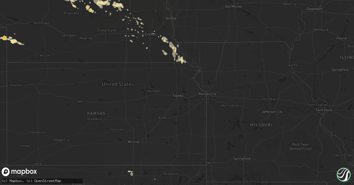
Hail Map in Nebraska on August 11, 2011
Get this storm
August 11 map
$229
one time, instant access
Download today. No call, no setup
Keep the $229
Bought the map and want the full workflow? Apply the entire $229 to a subscription within 7 days. None of it is wasted.
Every map, not just this one
This buys you this map. Subscription and you get every map we run, in the markets you choose from a few cities to whole states to nationwide. Plus real-time alerts the moment a storm fires.
Contact data
Name, contact info, occupancy, even credit band for addresses in the footprint. You go from where it hit to who to call.
Become the source they trust
Unlimited branding weather history reports on demand. You already have the documented answer ready for the property owner, and you are the one who showed up with it.
Property data and RoofTrace estimates
Pull up any address you have got, its value and the exact code rules for that jurisdiction, straight from One Click Code. Then RoofTrace estimates the squares, pitch, and roof value, priced the way you price.
Storm reports in Nebraska
Nebraska
| Date | Description |
|---|---|
| 08/11/20116:37 PM CDT | The brief...strong wind gust produced considerable blowing dust and was produced from a weakening shower. |
| 08/11/20116:15 AM CDT | This is a delayed report. Large trees with a diameter 10 to 12 inches uprooted. |
| 08/11/20116:12 AM CDT | This is a delayed report. Time estimated from radar. Some tree branch damage 4 to 6 inches in diameter and 1 pivot section tipped over just south of hordville. |
| 08/11/20116:12 AM CDT | This is a delayed report via emergency manager. |
| 08/11/20116:10 AM CDT | This is a delayed report. Time estimated from radar data. Large trees and powerlines down. Boats pulled loose from structures on the lake approximately 3 miles south of |
| 08/11/20113:05 AM CDT | A few tree branch limbs 2 inches in diameter were snapped off. |
| 08/11/20111:52 AM CDT | Estimated winds up to 60 mph. |
| 08/11/20111:52 AM CDT | Five to six large tree limbs or trees 8-10 inches in diameter downed. Delayed report time estimated by radar. |
| 08/11/20111:27 AM CDT | A local report indicates 1.00 inch wind near 1 N GORDON |
| 08/11/201112:40 AM CDT | A local report indicates 1.00 inch wind near BREWSTER |
| 08/11/201112:00 AM CDT | A local report indicates 1.75 inch wind near 10 NE DUNNING |
| 08/10/201111:30 PM CDT | A local report indicates 1.00 inch wind near 22 SE BROWNLEE |
| 08/10/201111:00 PM CDT | A local report indicates 1.00 inch wind near 6 SE BROWNLEE |
| 08/10/201110:40 PM CDT | Hail was falling at highway 91...mile marker 3 |
| 08/10/201110:02 PM CDT | Noted winds were from the south then rapidly switched around from the north as the storm passed. |
| 08/10/20119:53 PM CDT | Tornado snapped off several large limbs from elm trees that were displaced up to 300 feet to the south. Four power poles were broken on the south side of the road and a |
| 08/10/20119:10 PM CDT | A local report indicates 1.00 inch wind near 12 E BROWNLEE |
| 08/10/20119:02 PM CDT | Tornado on the ground 10 miles south and one mile east of johnstown |
| 08/10/20118:54 PM CDT | A local report indicates a tornado near 10 S JOHNSTOWN |
| 08/10/20118:40 PM CDT | A local report indicates 2.50 inch wind near 12 NW IMPERIAL |
| 08/10/20118:35 PM CDT | A local report indicates 2.75 inch wind near 29 S VALENTINE |
| 08/10/20118:32 PM CDT | A local report indicates 1.25 inch wind near 29 S VALENTINE |
| 08/10/20118:25 PM CDT | Relayed via the rock county sherrifs office. |
| 08/10/20118:22 PM CDT | Brief touchdown |
| 08/10/20118:15 PM CDT | A local report indicates 1.75 inch wind near 3 SW JOHNSTOWN |
| 08/10/20118:10 PM CDT | A local report indicates 1.25 inch wind near 8 SSE VENANGO |
| 08/10/20118:05 PM CDT | Estimating tornado being a quarter mile wide and have seen damage along tornado path |
| 08/10/20118:05 PM CDT | Tornado damaged two tree groves a half mile apart with several trees uprooted...numerous large branches broken and one tree debarked...uprooted and moved south to a fen |
| 08/10/20118:03 PM CDT | A local report indicates 1.00 inch wind near 4 ENE JOHNSTOWN |
| 08/10/20118:00 PM CDT | Debris in the air and possibly becoming rain wrapped. |
| 08/10/20118:00 PM CDT | Thunderstorm wind gusts downed tree limbs up to about 10 inches in diameter. |
| 08/10/20117:58 PM CDT | Sheriff deputy reported brief tornado touched down in an open field with no damage |
| 08/10/20117:49 PM CDT | Spotter was seeing debris flying under the funnel |
| 08/10/20117:28 PM CDT | A local report indicates 60 MPH wind near NAPER |
All States Impacted by Hail Map on August 11, 2011
Cities Impacted by Hail Map on August 11, 2011
- Buffalo, SD
- Genoa, CO
- Brundidge, AL
- Hardin, MT
- Crow Agency, MT
- Nazareth, TX
- Dimmitt, TX
- Stuart, NE
- Imperial, NE
- Springview, NE
- Mills, NE
- Decker, MT
- Nocona, TX
- Cobb, GA
- De Soto, GA
- Warwick, GA
- Cordele, GA
- Merriman, NE
- Gordon, NE
- Ainsworth, NE
- Bassett, NE
- Colome, SD
- Dallas, SD
- Fairburn, SD
- Hermosa, SD
- Pine Ridge, SD
- Purdum, NE
- Brewster, NE
- Rio Medina, TX
- Belle Fourche, SD
- Del Rio, TX
- Hammond, MT
- Ekalaka, MT
- Rattan, OK
- Whiteface, TX
- Gregory, SD
- Weston, WY
- Malta, MT
- Zortman, MT
- Rapid City, SD
- Ord, NE
- Havre, MT
- Camp Crook, SD
- Chamberlain, SD
- House, NM
- Brantley, AL
- Greenville, AL
- Holabird, SD
- Highmore, SD
- Pine Mountain, GA
- Beulah, WY
- Sundance, WY
- Cassatt, SC
- Bethune, SC
- Kershaw, SC
- Healdton, OK
- Graham, OK
- Braddock, ND
- Saint Francis, SD
- Midland, SD
- Cherry Creek, SD
- Milesville, SD
- Valentine, NE
- Hinsdale, MT
- Joliet, MT
- Erskine, MN
- Mentor, MN
- Lead, SD
- Silver City, NM
- Draper, SD
- Cooperstown, ND
- Marshall, OK
- Crescent, OK
- Rocksprings, TX
- Muleshoe, TX
- Sonora, TX
- Geary, OK
- Cody, NE
- Murdo, SD
- Okaton, SD
- Sacramento, NM
- Kennebec, SD
- Wood Lake, NE
- Belmont, NC
- Kit Carson, CO
- Okreek, SD
- Mission, SD
- Saco, MT
- Kingfisher, OK
- Clyde, TX
- Ree Heights, SD
- Gastonia, NC
- Dorchester, SC
- Perry, OK
- Plains, TX
- Deer Creek, OK
- Steele, ND
- Grant, NE
- Sheridan Lake, CO
- Vale, SD
- Plankinton, SD
- Harrold, SD
- Onida, SD
- Brock, NE
- Hayes, SD
- Terry, MT
- Falls City, NE
- Wessington Springs, SD
- Granite Falls, NC
- Hudson, NC
- Lenoir, NC
- Brackettville, TX
- Uvalde, TX
- Kilgore, NE
- Nenzel, NE
- Menno, SD
- Lesterville, SD
- Tulia, TX
- Lodge Grass, MT
- North Loup, NE
- Lloyd, MT
- Union, SC
- Boyd, TX
- Paradise, TX
- Eads, CO
- Wiley, CO
- Seward, NE
- Fort Pierre, SD
- Baker, MT
- Sargent, NE
- Anselmo, NE
- Taylor, NE
- Oshkosh, NE
- Saint Edward, NE
- Albion, NE
- Newman Grove, NE
- Fairmont, OK
- Niobrara, NE
- Springfield, SD
- Royal, NE
- Orchard, NE
- Winnetoon, NE
- Millersview, TX
- Broadus, MT
- Harleyville, SC
- Bowman, SC
- Saint George, SC
- Broken Bow, NE
- Perryton, TX
- Amherst, CO
- Thompson, ND
- Wakefield, NE
- Long Pine, NE
- Fort Towson, OK
- Sawyer, OK
- Winnett, MT
- Creighton, NE
- Arthur City, TX
- Paris, TX
- Detroit, TX
- Hugo, OK
- Roberts, MT
- Eastpoint, FL
- Clewiston, FL
- Nemo, SD
- Deadwood, SD
- Otter, MT
- Miller, SD
- Rush Springs, OK
- West Fork, AR
- Forestburg, TX
- Gaston, SC
- Saint Lawrence, SD
- Albany, GA
- Huntersville, NC
- Concord, NC
- Mauk, GA
- Box Springs, GA
- Junction City, GA
- Naper, NE
- Hennessey, OK
- Padroni, CO
- Hugo, CO
- Alvord, TX
- Chico, TX
- Harlem, MT
- Forsyth, MT
- Snow, OK
- Clayton, OK
- Marlow, OK
- Duncan, OK
- Snyder, TX
- Rotan, TX
- Hermleigh, TX
- Chauncey, GA
- Eastman, GA
- Milan, GA
- Burwell, NE
- Brainard, NE
- David City, NE
- Tilden, NE
- Blunt, SD
- Venango, NE
- Holyoke, CO
- Ideal, SD
- White River, SD
- Wood, SD
- Grand Forks, ND
- Primrose, NE
- Spalding, NE
- Auburn, NE
- Nemaha, NE
- Brownville, NE
- Unadilla, NE
- Verdigre, NE
- Regan, ND
- Ryan, OK
- Oneill, NE
- Burke, SD
- Wolbach, NE
- Washburn, ND
- Aladdin, WY
- Seibert, CO
- Lubbock, TX
- Lindsay, OK
- Bradley, OK
- Blanchard, OK
- Alex, OK
- Columbus, MT
- Willacoochee, GA
- Kress, TX
- Enders, NE
- Broxton, GA
- Hopkins, SC
- Eastover, SC
- Gadsden, SC
- Plainview, TX
- Olton, TX
- Crosby, ND
- Genoa, NE
- Baldwin, ND
- Fallon, MT
- Littlefield, TX
- Charlotte, NC
- Pompeys Pillar, MT
- Ballantine, MT
- Presho, SD
- Hays, MT
- Hartsville, SC
- Comanche, OK
- Bridgeport, TX
- Cedar Rapids, NE
- Lindsay, NE
- McCool Junction, NE
- Sweetwater, TX
- Lincoln, NE
- Champion, NE
- Minco, OK
- Peru, NE
- Watson, MO
- Platte, SD
- Hart, TX
- Midland, GA
- Lamar, CO
- Dadeville, AL
- Canyon, TX
- Happy, TX
- Oregon, MO
- Muscle Shoals, AL
- Okarche, OK
- Johnstown, NE
- Elsmere, NE
- Thedford, NE
- Silver Creek, NE
- Osceola, NE
- Utopia, TX
- Fedora, SD
- Artesian, SD
- Immokalee, FL
- Sedgwick, CO
- Halsey, NE
- Lower Brule, SD
- Lancaster, KS
- Everest, KS
- Eclectic, AL
- Kintyre, ND
- Swansea, SC
- Meridian, OK
- Dunbar, NE
- Otoe, NE
- Syracuse, NE
- Talmage, NE
- Roanoke, AL
- Woodland, AL
- Wedowee, AL
- Alamo, ND
- Panama City, FL
- Hondo, TX
- Dunning, NE
- Hitchcock, SD
- Wolsey, SD
- Scotland, SD
- Tyndall, SD
- Greeley, NE
- Scotia, NE
- Stromsburg, NE
- Crestview, FL
- Odonnell, TX
- Brunswick, NE
- Haxtun, CO
- Lynch, NE
- Hasty, CO
- McClave, CO
- Lance Creek, WY
- Hamilton, GA
- Ratliff City, OK
- Loco, OK
- Ringling, OK
- Saint Jo, TX
- Wilson, OK
- Springer, OK
- Spencer, NE
- Laurel, MT
- Avon, SD
- Wagner, SD
- Montague, TX
- Loring, MT
- Hulett, WY
- Pierre, SD
- Ambrose, GA
- Pukwana, SD
- Amelia, NE
- Waterloo, SC
- Arcadia, NE
- Cadwell, GA
- McRae Helena, GA
- Taiban, NM
- Roff, OK
- Winner, SD
- Buckhorn, NM
- Page, NE
- Watonga, OK
- Calumet, OK
- Greenfield, OK
- Driscoll, ND
- Exeter, NE
- Denton, KS
- Mott, ND
- White Lake, SD
- Waukomis, OK
- Bison, OK
- West Green, GA
- Sudan, TX
- McBee, SC
- Saint Xavier, MT
- Chickasha, OK
- Wilsall, MT
- Elgin, SC
- Blythewood, SC
- Upatoi, GA
- Earth, TX
- Cullman, AL
- Wayne, OK
- Purcell, OK
- Chinook, MT
- Neligh, NE
- Whitmire, SC
- El Reno, OK
- Wadley, AL
- Lafayette, AL
- Alapaha, GA
- Hennepin, OK
- Ringgold, TX
- Davis, OK
- Flagler, CO
- Maysville, OK
- Nicholls, GA
- Sulphur, OK
- Lagrange, GA
- West Point, GA
- Las Animas, CO
- Steinauer, NE
- Elk Creek, NE
- Lowell, NC
- Mount Holly, NC
- McAdenville, NC
- Moffit, ND
- Brockway, MT
- Springtown, TX
- Decatur, TX
- Battle Creek, NE
- Rayville, MO
- Richmond, MO
- Paoli, OK
- Pauls Valley, OK
- Wing, ND
- Defuniak Springs, FL
- Mico, TX
- San Antonio, TX
- Mountainburg, AR
- Winslow, AR
- Lawndale, NC
- Connelly Springs, NC
- Casar, NC
- Birney, MT
- Nardin, OK
- Blackwell, OK
- Alzada, MT
- Roscoe, TX
- Loraine, TX
- Freeport, FL
- Elgin, NE
- Clearwater, NE
- Petersburg, NE
- Dallas, NC
- Cramerton, NC
- Notasulga, AL
- Bloomfield, NE
- Rhine, GA
- Hillsboro, ND
- Antlers, OK
- Vona, CO
- Ashville, AL
- Bowie, TX
- Sunset, TX
- Cohagen, MT
- Putnam, OK
- Belvidere, SD
- Grant, OK
- Norman, OK
- Underwood, ND
- Hereford, TX
- Marion, SC
- Doerun, GA
- Zahl, ND
- Capitan, NM
- Monroe, NE
- Platte Center, NE
- West Columbia, SC
- Colorado City, TX
- Amber, OK
- Tuttle, OK
- Piedmont, OK
- Waco, NE
- Rushville, NE
- Lame Deer, MT
- Talihina, OK
- Muse, OK
- Whitesboro, OK
- Cragford, AL
- Daviston, AL
- Dwight, NE
- Caryville, FL
- Vernon, FL
- Franklin, GA
- Cookson, OK
- York, NE
- Shelby, NE
- Verden, OK
- Hawkinsville, GA
- Pineview, GA
- Waverly, NE
- Garland, NE
- Pleasant Dale, NE
- Camp Hill, AL
- Foster, OK
- Bagwell, TX
- Dozier, AL
- Eden, TX
- Wray, GA
- Butte, NE
- Junction, TX
- Wolf Point, MT
- Billings, MT
- Lamesa, TX
- Utica, NE
- Ebro, FL
- Table Rock, NE
- Tecumseh, NE
- Altoona, AL
- Martin, SD
- Killen, AL
- Town Creek, AL
- Edgemont, SD
- Ashland, AL
- Matthews, NC
- Rulo, NE
- Hiawatha, KS
- Wilber, NE
- Union City, OK
- Douglas, GA
- Spearfish, SD
- Bartlett, NE
- Wyola, MT
- Gann Valley, SD
- Chambers, NE
- Newport, NE
- Utica, SD
- Douglas, OK
- Herrick, SD
- Bonesteel, SD
- Atkinson, NE
- Rising City, NE
- Reliance, SD
- Coleman, OK
- McLaughlin, SD
- New Holland, SD
- Corsica, SD
- Harrison, SD
- Oacoma, SD
- Jasper, AL
- Spencer, SD
- Ewing, NE
- Arley, AL
- Russellville, AL
- Leighton, AL
- Tuskahoma, OK
- Tallassee, AL
- Clearmont, WY
- Sheridan, WY
- Moulton, AL
- Camden, SC
- Trinidad, CO
- Lexington, OK
- Kinsey, MT
- Bee, NE
- Fort Mill, SC
- Lynn Haven, FL
- Columbia, SC
- Sweet Grass, MT
- Cleveland, OK
- Cashion, OK
- Amidon, ND
- Philip, SD
- Concan, TX
- Jacksonville, GA
- Montezuma, GA
- Baker, FL
- Andersonville, GA
- Oglethorpe, GA
- Guthrie, OK
- Seminole, OK
- Bunch, OK
- Wauneta, NE
- Nashua, MT
- Springville, AL
- Darlington, SC
- Tryon, OK
- Clover, SC
- Patrick, SC
- Jefferson, SC
- Hitchcock, OK
- Sparks, NE
- Olivet, SD
- Lamont, OK
- Tonkawa, OK
- Dixon, NE
- Concord, NE
- Allen, NE
- Emerson, NE
- Wessington, SD
- Ardmore, OK
- Waurika, OK
- Tabor, SD
- Ocilla, GA
- Barksdale, TX
- Tripp, SD
- Julian, NE
- Nebraska City, NE
- Shubert, NE
- Johnson, NE
- Dawson, NE
- Humboldt, NE
- Verdon, NE
- Stella, NE
- Stanley, NC
- Wanette, OK
- Julesburg, CO
- Belgrade, NE
- Palmer, NE
- Woonsocket, SD
- Clayton, AL
- Laurel Hill, FL
- Hamill, SD
- Carrollton, MO
- Ulysses, NE
- Circle, MT
- Ramah, CO
- Matheson, CO
- Comstock, NE
- Plainview, NE
- Wynnewood, OK
- Milford, NE
- Leslie, GA
- Morton, TX
- De Witt, NE
- Elmore City, OK
- Waycross, GA
- Lindsay, MT
- Otis, CO
- Clatonia, NE
- Wewahitchka, FL
- Canute, OK
- Bessemer City, NC
- Double Springs, AL
- Houston, AL
- Parkston, SD
- Aberdeen, MS
- Regent, ND
- Abbeville, GA
- Craig, MO
- Ericson, NE
- Arriba, CO
- Fairfax, OK
- Florence, SC
- White Cloud, KS
- Salem, NE
- Dorchester, NE
- Beaver Crossing, NE
- Valliant, OK
- Meigs, GA
- Cornelius, NC
- Davidson, NC
- Pocasset, OK
- Fortson, GA
- Columbus, GA
- Laughlin Afb, TX
- Yukon, OK
- Columbus, NE
- Maud, OK
- Lugoff, SC
- Enochs, TX
- Glasgow, MT
- Sturgis, SD
- Chandler, OK
- Carney, OK
- Wellston, OK
- Kings Mountain, NC
- Hazlehurst, GA
- Ninnekah, OK
- Enid, OK
- Ridgeway, SC
- Troy, AL
- Crete, NE
- Bristow, NE
- Laurel, NE
- Leedey, OK
- Butler, OK
- Palmyra, NE


