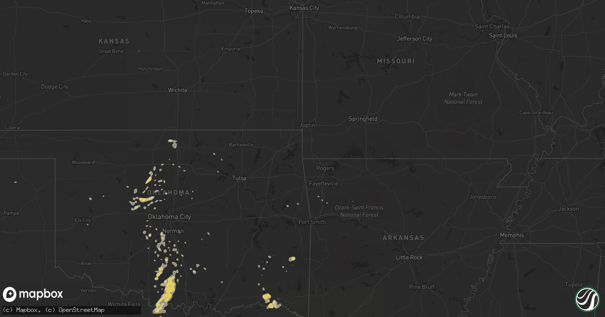
Hail Map on August 11, 2011
Get this storm
August 11 map
$229
one time, instant access
Download today. No call, no setup
Keep the $229
Bought the map and want the full workflow? Apply the entire $229 to a subscription within 7 days. None of it is wasted.
Every map, not just this one
This buys you this map. Subscription and you get every map we run, in the markets you choose from a few cities to whole states to nationwide. Plus real-time alerts the moment a storm fires.
Contact data
Name, contact info, occupancy, even credit band for addresses in the footprint. You go from where it hit to who to call.
Become the source they trust
Unlimited branding weather history reports on demand. You already have the documented answer ready for the property owner, and you are the one who showed up with it.
Property data and RoofTrace estimates
Pull up any address you have got, its value and the exact code rules for that jurisdiction, straight from One Click Code. Then RoofTrace estimates the squares, pitch, and roof value, priced the way you price.
States Impacted by Hail Map on August 11, 2011
Storm reports
South Dakota
| Date | Description |
|---|---|
| 08/11/20116:35 PM CDT | A local report indicates 1.00 inch wind near 2 SE CARTER |
| 08/11/20116:30 PM CDT | Branches knocked off. .75 inches of rain. |
| 08/11/20116:20 PM CDT | A local report indicates 70 MPH wind near OACOMA |
| 08/11/20116:07 PM CDT | Roof removed off local business and blown into powerlines. |
| 08/11/20116:00 PM CDT | Pea size hail with the wind. |
| 08/11/20115:58 PM CDT | A local report indicates 60 MPH wind near 6 NE WOOD |
| 08/11/20115:52 PM CDT | Gusts 60 to 70 mph |
| 08/11/20115:45 PM CDT | Shingles blown off of house and damage to deck. Lots of tree damage. |
| 08/11/20115:40 PM CDT | Grain bins blown over. Trucks blown off of highway. |
| 08/11/20115:40 PM CDT | A local report indicates 62 MPH wind near MILLER |
| 08/11/20115:30 PM CDT | A local report indicates 76 MPH wind near 9 S FORT PIERRE |
| 08/11/20115:05 PM CDT | Quarter size hail in murdo proper |
| 08/11/20114:58 PM CDT | A local report indicates 1.00 inch wind near 11 NW DOWNTOWN RAPID CI |
| 08/11/20114:47 PM CDT | Ping pong sized hail and 60 mph winds reported |
| 08/11/20114:47 PM CDT | Ping pong sized hail and 60 mph winds reported |
| 08/11/20114:30 PM CDT | A local report indicates 1.75 inch wind near 8 S DEADWOOD |
| 08/11/20114:25 PM CDT | A local report indicates 1.25 inch wind near 7 N MIDLAND |
| 08/11/20114:20 PM CDT | Hail in drifts up to 1 foot deep. |
| 08/11/20113:00 PM CDT | A local report indicates 2.00 inch wind near 4 S MILESVILLE |
| 08/11/20112:55 PM CDT | A local report indicates 2.75 inch wind near 6 NW MILESVILLE |
| 08/11/20111:50 PM CDT | A local report indicates 1.00 inch wind near 4 S PACTOLA RESERVOIR |
| 08/10/20119:35 PM CDT | Marble size hail. |
| 08/10/20119:20 PM CDT | Gusts estimated at up to 50 mph. |
| 08/10/20118:55 PM CDT | Pea size hail. |
| 08/10/20118:05 PM CDT | Also pea sized hail |
| 08/10/20117:40 PM CDT | Trees and powerlines down |
| 08/10/20117:20 PM CDT | A local report indicates 1.75 inch wind near 11 E WEWELA |
| 08/10/20117:09 PM CDT | A local report indicates 61 MPH wind near HURON |
New Mexico
| Date | Description |
|---|---|
| 08/11/20116:38 PM CDT | Krow asos. |
Texas
| Date | Description |
|---|---|
| 08/11/20116:30 PM CDT | Lines blown down on fm 1424 |
| 08/11/20116:30 PM CDT | Significant damage to dimmitt mesonet station. Damage to radiation shields... Guide wires pulled out of ground and a pole bent. Center pivot damaged in vicinity of meso |
| 08/11/20116:27 PM CDT | Feed lot office heavily damaged in dimmitt from strong thunderstorm winds |
| 08/11/20116:15 PM CDT | 7 power poles down at county rd 621 and fm 1055 |
| 08/11/20115:26 PM CDT | Power lines down... Roof damage... Trees down in olton |
| 08/11/20115:26 PM CDT | A local report indicates 1.00 inch wind near OLTON |
| 08/11/20115:18 PM CDT | Reported by kamc automated weather station |
| 08/11/20115:18 PM CDT | Reported by kamc automated weather station at olton airport |
| 08/10/20117:20 PM CDT | A local report indicates 70 MPH wind near 9 SSE UMBARGER |
| 08/10/20117:16 PM CDT | Lost power |
Montana
| Date | Description |
|---|---|
| 08/11/20116:37 PM CDT | 1 inch hail at downtown havre. |
| 08/11/20116:30 PM CDT | Tree limbs broken and leaves gone |
| 08/11/20116:20 PM CDT | Estimated 50 mph winds combined with the hail to break windows. Hail accumulated to 6 to 8 inches. |
| 08/11/20116:20 PM CDT | 60-70 mph winds with one half inch hail. Large trees missing limbs and leaves. |
| 08/11/20116:00 PM CDT | Winds at 75 mph driving dime size hail. Heavy damage to home. Power poles blown down. 300 acres sugar beet crop destroyed. Numerous vehicles with broken windows seen on |
| 08/11/20115:58 PM CDT | Accompanied by brief heavy rain. |
| 08/11/20115:58 PM CDT | A local report indicates 60 MPH wind near 4 N SACO |
| 08/11/20115:46 PM CDT | Broken windows due to hail and rain. Hail size unknown. Crops flattened. Sheds blown over. |
| 08/11/20115:45 PM CDT | Large tree downed in town. |
| 08/11/20114:58 PM CDT | A local report indicates 1.00 inch wind near BALLANTINE |
| 08/11/20114:55 PM CDT | A local report indicates 1.00 inch wind near 3 W WORDEN |
| 08/11/20114:20 PM CDT | A local report indicates 1.00 inch wind near 10 SE JORDAN |
| 08/11/20114:05 PM CDT | A local report indicates 1.00 inch wind near 10 SE JORDAN |
| 08/11/20111:27 PM CDT | A local report indicates 1.00 inch wind near 3 W WORDEN |
| 08/11/20111:27 PM CDT | A local report indicates 1.00 inch wind near BALLANTINE |
| 08/10/20118:30 PM CDT | 50-60 mph winds driving quarter size hail and heavy rains. |
| 08/10/20118:15 PM CDT | Very strong winds broke twigs and snapped 2 inch branches off of trees. Measured 0.10 of rain. |
| 08/10/20117:45 PM CDT | A local report indicates 60 MPH wind near BROADUS |
| 08/10/20117:08 PM CDT | Along with dime size hail and received 0.54 inches rain. |
Florida
| Date | Description |
|---|---|
| 08/11/20116:15 PM CDT | The jacksonville electric authority confirmed that power line crews responded to scattered power outages across the jacksonville southside inlcuding along san pablo and |
| 08/11/20111:48 PM CDT | Tree limbs down as well as damage to a homemade greenhouse. |
North Carolina
| Date | Description |
|---|---|
| 08/11/20115:12 PM CDT | Trees down on pleasant grove road. |
| 08/11/20115:00 PM CDT | Large tree on road. |
| 08/11/20115:00 PM CDT | A few trees down in water oak area. |
| 08/11/20114:55 PM CDT | County reports a structure moved off its foundation by wind gusts at abby walk lane near mckee road. |
| 08/11/20114:30 PM CDT | Quarter size hail on south blvd in charlotte. |
| 08/11/20114:20 PM CDT | Debris in roadway from winds at yorkmont and billy graham parkway near charlotte airport. |
| 08/11/20114:13 PM CDT | Measured 50 kt gust at clt airport. |
| 08/11/20114:08 PM CDT | Half dollar sized hail falling just outside of belmont. |
| 08/11/20114:08 PM CDT | A few large limbs down along with the large hail. |
| 08/11/20114:00 PM CDT | Spotter reports quarter size hail along hickory grove road. |
| 08/11/20113:40 PM CDT | Spotter took a photograph of approaching storm at fire department which verified this time. Several large limbs were downed from this storm as it went through the area. |
| 08/11/20113:32 PM CDT | Several trees down in and around dallas...2 trees that fell on separate houses...and several other trees either down or snapped off about half way up the tree. |
| 08/11/20113:26 PM CDT | Six aircraft damaged and one tree down at kjqf concord regional airport. |
| 08/11/20113:18 PM CDT | Trees and power lines down along old statesville road. |
| 08/11/20113:15 PM CDT | Trees and power lines down along bethel church road. |
| 08/11/20113:10 PM CDT | Davidson p.d. Reports 10 to 15 trees blown down or topped by wind along main street. Rail fence leveled by wind as well. |
| 08/11/20113:06 PM CDT | Several large limbs and at least one pine tree down along with some powerlines down in davidson. The time was obtained from doppler velocity data as the wind max crosse |
| 08/11/20111:56 PM CDT | At least one large tree down in the davie academy road area along with several other large branches. This location is just south of interstate 40. |
| 08/11/20111:49 PM CDT | Two trees down on hwy 10 in between casar and toluca. |
| 08/11/201112:54 PM CDT | Quarter size hail near hwy 321-a and connelly springs rd. |
| 08/11/201112:51 PM CDT | Tree down |
| 08/11/201112:40 PM CDT | 3 trees down |
Virginia
| Date | Description |
|---|---|
| 08/11/20115:15 PM CDT | Tree down on power line |
| 08/11/20115:15 PM CDT | Damage to house and fences |
Wyoming
| Date | Description |
|---|---|
| 08/10/20118:06 PM CDT | Pea size hail. |
| 08/10/20117:52 PM CDT | A local report indicates 60 MPH wind near 25 NNE WESTON |
North Dakota
| Date | Description |
|---|---|
| 08/11/20115:45 PM CDT | 12-inch diameter tree snapped at root at corner of 28th ave and oak street. Time approximate. |
| 08/11/20115:37 PM CDT | Quarter to half dollar sized hail fell. |
Oklahoma
| Date | Description |
|---|---|
| 08/11/201111:00 AM CDT | A local report indicates 62 MPH wind near 7 WNW ARDMORE |
| 08/11/20119:25 AM CDT | Blanchard pd |
Georgia
| Date | Description |
|---|---|
| 08/11/20116:25 PM CDT | Three trees were blown down onto power lines along the gibbs street extention. |
| 08/11/20116:23 PM CDT | Trained spotter reported numerous downed trees on powerlines. |
| 08/11/20115:45 PM CDT | Emergency manager reported straight line wind event on antioch church road that knocked several trees onto a power substation. This event knocked power out to a large p |
| 08/11/20115:45 PM CDT | Emergency manager reported straight line wind event on sutton road that tore the front porch awning off a mobile home and peeled back part of the roof. No injuries were |
| 08/11/20115:30 PM CDT | 911 center relayed public report of structural damage to residential home along with downed trees. Time estimated by doppler radar. |
| 08/11/20115:05 PM CDT | Trees were blown down along mora road and bridgetown road. |
| 08/11/20114:55 PM CDT | Trees were down along yawn road. The time of damage was based on radar. |
| 08/11/20111:54 PM CDT | Marion county 911 relayed reports of a couple of downed trees. |
| 08/11/20111:35 PM CDT | Wtvm-tv relayed reports of a few downed trees and powerlines in waverly hall. |
| 08/11/20111:31 PM CDT | Waverly hall police department reports several trees and lines down on ga hwy 85 heading towards manchester. |
| 08/11/20111:00 PM CDT | Harris county 911 reports several downed trees in the northwestern portion of county. |
South Carolina
| Date | Description |
|---|---|
| 08/11/20116:26 PM CDT | Tree down on ruby road near chapel hill road. Time of event estimated by radar. |
| 08/11/20114:55 PM CDT | Several trees down across tee pee trail rd. |
| 08/11/20114:54 PM CDT | Trees down along sessions road near 25 mile creek. |
| 08/11/20114:40 PM CDT | Several trees down on maybinton rd. Time estimated by radar. |
| 08/11/20114:23 PM CDT | Tree down on lee cemetary rd. Time estimated from radar. |
| 08/11/20114:18 PM CDT | Power lines down at sardis rd and old buncombe rd. Tree also down on old buncombe rd. Time estimated from radar. |
| 08/11/20114:00 PM CDT | Several trees down in this area...4 trees down on lee cemetery road...trees on powerlines at intersection of sardis road and old buncombe road...a tree down in the 5400 |
| 08/11/20113:25 PM CDT | Several trees down on ebenezer rd. |
| 08/11/20113:00 PM CDT | Several trees down in this area...4 trees down on lee cemetery road...trees on powerlines at sardis road and old bumcombe road...tree down in the 5400 block of whitmire |
| 08/11/20113:00 PM CDT | Quarter size hail and one oak tree blown down on harts road. |
| 08/11/20113:00 PM CDT | Quarter size hail and one oak tree blown down on harts road. |
| 08/10/20118:35 PM CDT | Tree down across state road s-34-9 near gresham. |
| 08/10/20118:00 PM CDT | Tree down near intersection of antioch church road and sc 38. Time of event esimtated by radar. |
| 08/10/20117:37 PM CDT | Tree down on mechanicville rd. |
| 08/10/20117:35 PM CDT | Tree down on hoffmyer rd near entrance to florence mall. |
| 08/10/20117:24 PM CDT | Tree down in oak grove area near elberry rd. Time of event estimated by radar. |
Nebraska
| Date | Description |
|---|---|
| 08/11/20116:37 PM CDT | The brief...strong wind gust produced considerable blowing dust and was produced from a weakening shower. |
| 08/11/20116:15 AM CDT | This is a delayed report. Large trees with a diameter 10 to 12 inches uprooted. |
| 08/11/20116:12 AM CDT | This is a delayed report via emergency manager. |
| 08/11/20116:12 AM CDT | This is a delayed report. Time estimated from radar. Some tree branch damage 4 to 6 inches in diameter and 1 pivot section tipped over just south of hordville. |
| 08/11/20116:10 AM CDT | This is a delayed report. Time estimated from radar data. Large trees and powerlines down. Boats pulled loose from structures on the lake approximately 3 miles south of |
| 08/11/20113:05 AM CDT | A few tree branch limbs 2 inches in diameter were snapped off. |
| 08/11/20111:52 AM CDT | Five to six large tree limbs or trees 8-10 inches in diameter downed. Delayed report time estimated by radar. |
| 08/11/20111:52 AM CDT | Estimated winds up to 60 mph. |
| 08/11/20111:27 AM CDT | A local report indicates 1.00 inch wind near 1 N GORDON |
| 08/11/201112:40 AM CDT | A local report indicates 1.00 inch wind near BREWSTER |
| 08/11/201112:00 AM CDT | A local report indicates 1.75 inch wind near 10 NE DUNNING |
| 08/10/201111:30 PM CDT | A local report indicates 1.00 inch wind near 22 SE BROWNLEE |
| 08/10/201111:00 PM CDT | A local report indicates 1.00 inch wind near 6 SE BROWNLEE |
| 08/10/201110:40 PM CDT | Hail was falling at highway 91...mile marker 3 |
| 08/10/201110:02 PM CDT | Noted winds were from the south then rapidly switched around from the north as the storm passed. |
| 08/10/20119:53 PM CDT | Tornado snapped off several large limbs from elm trees that were displaced up to 300 feet to the south. Four power poles were broken on the south side of the road and a |
| 08/10/20119:10 PM CDT | A local report indicates 1.00 inch wind near 12 E BROWNLEE |
| 08/10/20119:02 PM CDT | Tornado on the ground 10 miles south and one mile east of johnstown |
| 08/10/20118:54 PM CDT | A local report indicates a tornado near 10 S JOHNSTOWN |
| 08/10/20118:40 PM CDT | A local report indicates 2.50 inch wind near 12 NW IMPERIAL |
| 08/10/20118:35 PM CDT | A local report indicates 2.75 inch wind near 29 S VALENTINE |
| 08/10/20118:32 PM CDT | A local report indicates 1.25 inch wind near 29 S VALENTINE |
| 08/10/20118:25 PM CDT | Relayed via the rock county sherrifs office. |
| 08/10/20118:22 PM CDT | Brief touchdown |
| 08/10/20118:15 PM CDT | A local report indicates 1.75 inch wind near 3 SW JOHNSTOWN |
| 08/10/20118:10 PM CDT | A local report indicates 1.25 inch wind near 8 SSE VENANGO |
| 08/10/20118:05 PM CDT | Tornado damaged two tree groves a half mile apart with several trees uprooted...numerous large branches broken and one tree debarked...uprooted and moved south to a fen |
| 08/10/20118:05 PM CDT | Estimating tornado being a quarter mile wide and have seen damage along tornado path |
| 08/10/20118:03 PM CDT | A local report indicates 1.00 inch wind near 4 ENE JOHNSTOWN |
| 08/10/20118:00 PM CDT | Debris in the air and possibly becoming rain wrapped. |
| 08/10/20118:00 PM CDT | Thunderstorm wind gusts downed tree limbs up to about 10 inches in diameter. |
| 08/10/20117:58 PM CDT | Sheriff deputy reported brief tornado touched down in an open field with no damage |
| 08/10/20117:49 PM CDT | Spotter was seeing debris flying under the funnel |
| 08/10/20117:28 PM CDT | A local report indicates 60 MPH wind near NAPER |
Alabama
| Date | Description |
|---|---|
| 08/11/20116:41 PM CDT | Mulitple trees and powerlines down in the walnut hill area near the intersection of county roads 50 and 49. |
| 08/11/20115:02 PM CDT | Multiple trees blown down around spout springs road and wheeler view drive northeast of ford city. |
| 08/11/20115:02 PM CDT | Multiple trees blown down around scott springs road and wheeler view drive northeast of ford city. |
| 08/11/20115:00 PM CDT | Quarter size hail reported in the town of center star. |
| 08/11/20114:50 PM CDT | Quarter size hail reported in the town of center star. Time estimated based on radar. |
Kansas
| Date | Description |
|---|---|
| 08/11/20112:02 AM CDT | A local report indicates 62 MPH wind near SYRACUSE |
Minnesota
| Date | Description |
|---|---|
| 08/11/20113:50 PM CDT | Quarter to walnut sized hail for a few minutes. |
Colorado
| Date | Description |
|---|---|
| 08/11/20116:00 PM CDT | 2 foot diameter live spruce tree uprooted. Strong winds lasted less than 1 minute. |
| 08/10/20118:34 PM CDT | A local report indicates 1.50 inch wind near 5 WNW HOLYOKE |
| 08/10/20118:05 PM CDT | Several trees uprooted |
| 08/10/20117:47 PM CDT | A local report indicates 1.50 inch wind near 3 E AMHERST |
| 08/10/20117:38 PM CDT | Sheets of half inch to one inch hail. Crop damage likely. |
| 08/10/20117:15 PM CDT | 14 power poles down between road 13.5 and 14. |
Cities Impacted by Hail Map on August 11, 2011
- Buffalo, SD
- Genoa, CO
- Brundidge, AL
- Hardin, MT
- Crow Agency, MT
- Nazareth, TX
- Dimmitt, TX
- Stuart, NE
- Imperial, NE
- Springview, NE
- Mills, NE
- Decker, MT
- Nocona, TX
- Cobb, GA
- De Soto, GA
- Warwick, GA
- Cordele, GA
- Merriman, NE
- Gordon, NE
- Ainsworth, NE
- Bassett, NE
- Colome, SD
- Dallas, SD
- Fairburn, SD
- Hermosa, SD
- Pine Ridge, SD
- Purdum, NE
- Brewster, NE
- Rio Medina, TX
- Belle Fourche, SD
- Del Rio, TX
- Hammond, MT
- Ekalaka, MT
- Rattan, OK
- Whiteface, TX
- Gregory, SD
- Weston, WY
- Malta, MT
- Zortman, MT
- Rapid City, SD
- Ord, NE
- Havre, MT
- Camp Crook, SD
- Chamberlain, SD
- House, NM
- Brantley, AL
- Greenville, AL
- Holabird, SD
- Highmore, SD
- Pine Mountain, GA
- Beulah, WY
- Sundance, WY
- Cassatt, SC
- Bethune, SC
- Kershaw, SC
- Healdton, OK
- Graham, OK
- Braddock, ND
- Saint Francis, SD
- Midland, SD
- Cherry Creek, SD
- Milesville, SD
- Valentine, NE
- Hinsdale, MT
- Joliet, MT
- Erskine, MN
- Mentor, MN
- Lead, SD
- Silver City, NM
- Draper, SD
- Cooperstown, ND
- Marshall, OK
- Crescent, OK
- Rocksprings, TX
- Muleshoe, TX
- Sonora, TX
- Geary, OK
- Cody, NE
- Murdo, SD
- Okaton, SD
- Sacramento, NM
- Kennebec, SD
- Wood Lake, NE
- Belmont, NC
- Kit Carson, CO
- Okreek, SD
- Mission, SD
- Saco, MT
- Kingfisher, OK
- Clyde, TX
- Ree Heights, SD
- Gastonia, NC
- Dorchester, SC
- Perry, OK
- Plains, TX
- Deer Creek, OK
- Steele, ND
- Grant, NE
- Sheridan Lake, CO
- Vale, SD
- Plankinton, SD
- Harrold, SD
- Onida, SD
- Brock, NE
- Hayes, SD
- Terry, MT
- Falls City, NE
- Wessington Springs, SD
- Granite Falls, NC
- Hudson, NC
- Lenoir, NC
- Brackettville, TX
- Uvalde, TX
- Kilgore, NE
- Nenzel, NE
- Menno, SD
- Lesterville, SD
- Tulia, TX
- Lodge Grass, MT
- North Loup, NE
- Lloyd, MT
- Union, SC
- Boyd, TX
- Paradise, TX
- Eads, CO
- Wiley, CO
- Seward, NE
- Fort Pierre, SD
- Baker, MT
- Sargent, NE
- Anselmo, NE
- Taylor, NE
- Oshkosh, NE
- Saint Edward, NE
- Albion, NE
- Newman Grove, NE
- Fairmont, OK
- Niobrara, NE
- Springfield, SD
- Royal, NE
- Orchard, NE
- Winnetoon, NE
- Millersview, TX
- Broadus, MT
- Harleyville, SC
- Bowman, SC
- Saint George, SC
- Broken Bow, NE
- Perryton, TX
- Amherst, CO
- Thompson, ND
- Wakefield, NE
- Long Pine, NE
- Fort Towson, OK
- Sawyer, OK
- Winnett, MT
- Creighton, NE
- Arthur City, TX
- Paris, TX
- Detroit, TX
- Hugo, OK
- Roberts, MT
- Eastpoint, FL
- Clewiston, FL
- Nemo, SD
- Deadwood, SD
- Otter, MT
- Miller, SD
- Rush Springs, OK
- West Fork, AR
- Forestburg, TX
- Gaston, SC
- Saint Lawrence, SD
- Albany, GA
- Huntersville, NC
- Concord, NC
- Mauk, GA
- Box Springs, GA
- Junction City, GA
- Naper, NE
- Hennessey, OK
- Padroni, CO
- Hugo, CO
- Alvord, TX
- Chico, TX
- Harlem, MT
- Forsyth, MT
- Snow, OK
- Clayton, OK
- Marlow, OK
- Duncan, OK
- Snyder, TX
- Rotan, TX
- Hermleigh, TX
- Chauncey, GA
- Eastman, GA
- Milan, GA
- Burwell, NE
- Brainard, NE
- David City, NE
- Tilden, NE
- Blunt, SD
- Venango, NE
- Holyoke, CO
- Ideal, SD
- White River, SD
- Wood, SD
- Grand Forks, ND
- Primrose, NE
- Spalding, NE
- Auburn, NE
- Nemaha, NE
- Brownville, NE
- Unadilla, NE
- Verdigre, NE
- Regan, ND
- Ryan, OK
- Oneill, NE
- Burke, SD
- Wolbach, NE
- Washburn, ND
- Aladdin, WY
- Seibert, CO
- Lubbock, TX
- Lindsay, OK
- Bradley, OK
- Blanchard, OK
- Alex, OK
- Columbus, MT
- Willacoochee, GA
- Kress, TX
- Enders, NE
- Broxton, GA
- Hopkins, SC
- Eastover, SC
- Gadsden, SC
- Plainview, TX
- Olton, TX
- Crosby, ND
- Genoa, NE
- Baldwin, ND
- Fallon, MT
- Littlefield, TX
- Charlotte, NC
- Pompeys Pillar, MT
- Ballantine, MT
- Presho, SD
- Hays, MT
- Hartsville, SC
- Comanche, OK
- Bridgeport, TX
- Cedar Rapids, NE
- Lindsay, NE
- McCool Junction, NE
- Sweetwater, TX
- Lincoln, NE
- Champion, NE
- Minco, OK
- Peru, NE
- Watson, MO
- Platte, SD
- Hart, TX
- Midland, GA
- Lamar, CO
- Dadeville, AL
- Canyon, TX
- Happy, TX
- Oregon, MO
- Muscle Shoals, AL
- Okarche, OK
- Johnstown, NE
- Elsmere, NE
- Thedford, NE
- Silver Creek, NE
- Osceola, NE
- Utopia, TX
- Fedora, SD
- Artesian, SD
- Immokalee, FL
- Sedgwick, CO
- Halsey, NE
- Lower Brule, SD
- Lancaster, KS
- Everest, KS
- Eclectic, AL
- Kintyre, ND
- Swansea, SC
- Meridian, OK
- Dunbar, NE
- Otoe, NE
- Syracuse, NE
- Talmage, NE
- Roanoke, AL
- Woodland, AL
- Wedowee, AL
- Alamo, ND
- Panama City, FL
- Hondo, TX
- Dunning, NE
- Hitchcock, SD
- Wolsey, SD
- Scotland, SD
- Tyndall, SD
- Greeley, NE
- Scotia, NE
- Stromsburg, NE
- Crestview, FL
- Odonnell, TX
- Brunswick, NE
- Haxtun, CO
- Lynch, NE
- Hasty, CO
- McClave, CO
- Lance Creek, WY
- Hamilton, GA
- Ratliff City, OK
- Loco, OK
- Ringling, OK
- Saint Jo, TX
- Wilson, OK
- Springer, OK
- Spencer, NE
- Laurel, MT
- Avon, SD
- Wagner, SD
- Montague, TX
- Loring, MT
- Hulett, WY
- Pierre, SD
- Ambrose, GA
- Pukwana, SD
- Amelia, NE
- Waterloo, SC
- Arcadia, NE
- Cadwell, GA
- McRae Helena, GA
- Taiban, NM
- Roff, OK
- Winner, SD
- Buckhorn, NM
- Page, NE
- Watonga, OK
- Calumet, OK
- Greenfield, OK
- Driscoll, ND
- Exeter, NE
- Denton, KS
- Mott, ND
- White Lake, SD
- Waukomis, OK
- Bison, OK
- West Green, GA
- Sudan, TX
- McBee, SC
- Saint Xavier, MT
- Chickasha, OK
- Wilsall, MT
- Elgin, SC
- Blythewood, SC
- Upatoi, GA
- Earth, TX
- Cullman, AL
- Wayne, OK
- Purcell, OK
- Chinook, MT
- Neligh, NE
- Whitmire, SC
- El Reno, OK
- Wadley, AL
- Lafayette, AL
- Alapaha, GA
- Hennepin, OK
- Ringgold, TX
- Davis, OK
- Flagler, CO
- Maysville, OK
- Nicholls, GA
- Sulphur, OK
- Lagrange, GA
- West Point, GA
- Las Animas, CO
- Steinauer, NE
- Elk Creek, NE
- Lowell, NC
- Mount Holly, NC
- McAdenville, NC
- Moffit, ND
- Brockway, MT
- Springtown, TX
- Decatur, TX
- Battle Creek, NE
- Rayville, MO
- Richmond, MO
- Paoli, OK
- Pauls Valley, OK
- Wing, ND
- Defuniak Springs, FL
- Mico, TX
- San Antonio, TX
- Mountainburg, AR
- Winslow, AR
- Lawndale, NC
- Connelly Springs, NC
- Casar, NC
- Birney, MT
- Nardin, OK
- Blackwell, OK
- Alzada, MT
- Roscoe, TX
- Loraine, TX
- Freeport, FL
- Elgin, NE
- Clearwater, NE
- Petersburg, NE
- Dallas, NC
- Cramerton, NC
- Notasulga, AL
- Bloomfield, NE
- Rhine, GA
- Hillsboro, ND
- Antlers, OK
- Vona, CO
- Ashville, AL
- Bowie, TX
- Sunset, TX
- Cohagen, MT
- Putnam, OK
- Belvidere, SD
- Grant, OK
- Norman, OK
- Underwood, ND
- Hereford, TX
- Marion, SC
- Doerun, GA
- Zahl, ND
- Capitan, NM
- Monroe, NE
- Platte Center, NE
- West Columbia, SC
- Colorado City, TX
- Amber, OK
- Tuttle, OK
- Piedmont, OK
- Waco, NE
- Rushville, NE
- Lame Deer, MT
- Talihina, OK
- Muse, OK
- Whitesboro, OK
- Cragford, AL
- Daviston, AL
- Dwight, NE
- Caryville, FL
- Vernon, FL
- Franklin, GA
- Cookson, OK
- York, NE
- Shelby, NE
- Verden, OK
- Hawkinsville, GA
- Pineview, GA
- Waverly, NE
- Garland, NE
- Pleasant Dale, NE
- Camp Hill, AL
- Foster, OK
- Bagwell, TX
- Dozier, AL
- Eden, TX
- Wray, GA
- Butte, NE
- Junction, TX
- Wolf Point, MT
- Billings, MT
- Lamesa, TX
- Utica, NE
- Ebro, FL
- Table Rock, NE
- Tecumseh, NE
- Altoona, AL
- Martin, SD
- Killen, AL
- Town Creek, AL
- Edgemont, SD
- Ashland, AL
- Matthews, NC
- Rulo, NE
- Hiawatha, KS
- Wilber, NE
- Union City, OK
- Douglas, GA
- Spearfish, SD
- Bartlett, NE
- Wyola, MT
- Gann Valley, SD
- Chambers, NE
- Newport, NE
- Utica, SD
- Douglas, OK
- Herrick, SD
- Bonesteel, SD
- Atkinson, NE
- Rising City, NE
- Reliance, SD
- Coleman, OK
- McLaughlin, SD
- New Holland, SD
- Corsica, SD
- Harrison, SD
- Oacoma, SD
- Jasper, AL
- Spencer, SD
- Ewing, NE
- Arley, AL
- Russellville, AL
- Leighton, AL
- Tuskahoma, OK
- Tallassee, AL
- Clearmont, WY
- Sheridan, WY
- Moulton, AL
- Camden, SC
- Trinidad, CO
- Lexington, OK
- Kinsey, MT
- Bee, NE
- Fort Mill, SC
- Lynn Haven, FL
- Columbia, SC
- Sweet Grass, MT
- Cleveland, OK
- Cashion, OK
- Amidon, ND
- Philip, SD
- Concan, TX
- Jacksonville, GA
- Montezuma, GA
- Baker, FL
- Andersonville, GA
- Oglethorpe, GA
- Guthrie, OK
- Seminole, OK
- Bunch, OK
- Wauneta, NE
- Nashua, MT
- Springville, AL
- Darlington, SC
- Tryon, OK
- Clover, SC
- Patrick, SC
- Jefferson, SC
- Hitchcock, OK
- Sparks, NE
- Olivet, SD
- Lamont, OK
- Tonkawa, OK
- Dixon, NE
- Concord, NE
- Allen, NE
- Emerson, NE
- Wessington, SD
- Ardmore, OK
- Waurika, OK
- Tabor, SD
- Ocilla, GA
- Barksdale, TX
- Tripp, SD
- Julian, NE
- Nebraska City, NE
- Shubert, NE
- Johnson, NE
- Dawson, NE
- Humboldt, NE
- Verdon, NE
- Stella, NE
- Stanley, NC
- Wanette, OK
- Julesburg, CO
- Belgrade, NE
- Palmer, NE
- Woonsocket, SD
- Clayton, AL
- Laurel Hill, FL
- Hamill, SD
- Carrollton, MO
- Ulysses, NE
- Circle, MT
- Ramah, CO
- Matheson, CO
- Comstock, NE
- Plainview, NE
- Wynnewood, OK
- Milford, NE
- Leslie, GA
- Morton, TX
- De Witt, NE
- Elmore City, OK
- Waycross, GA
- Lindsay, MT
- Otis, CO
- Clatonia, NE
- Wewahitchka, FL
- Canute, OK
- Bessemer City, NC
- Double Springs, AL
- Houston, AL
- Parkston, SD
- Aberdeen, MS
- Regent, ND
- Abbeville, GA
- Craig, MO
- Ericson, NE
- Arriba, CO
- Fairfax, OK
- Florence, SC
- White Cloud, KS
- Salem, NE
- Dorchester, NE
- Beaver Crossing, NE
- Valliant, OK
- Meigs, GA
- Cornelius, NC
- Davidson, NC
- Pocasset, OK
- Fortson, GA
- Columbus, GA
- Laughlin Afb, TX
- Yukon, OK
- Columbus, NE
- Maud, OK
- Lugoff, SC
- Enochs, TX
- Glasgow, MT
- Sturgis, SD
- Chandler, OK
- Carney, OK
- Wellston, OK
- Kings Mountain, NC
- Hazlehurst, GA
- Ninnekah, OK
- Enid, OK
- Ridgeway, SC
- Troy, AL
- Crete, NE
- Bristow, NE
- Laurel, NE
- Leedey, OK
- Butler, OK
- Palmyra, NE