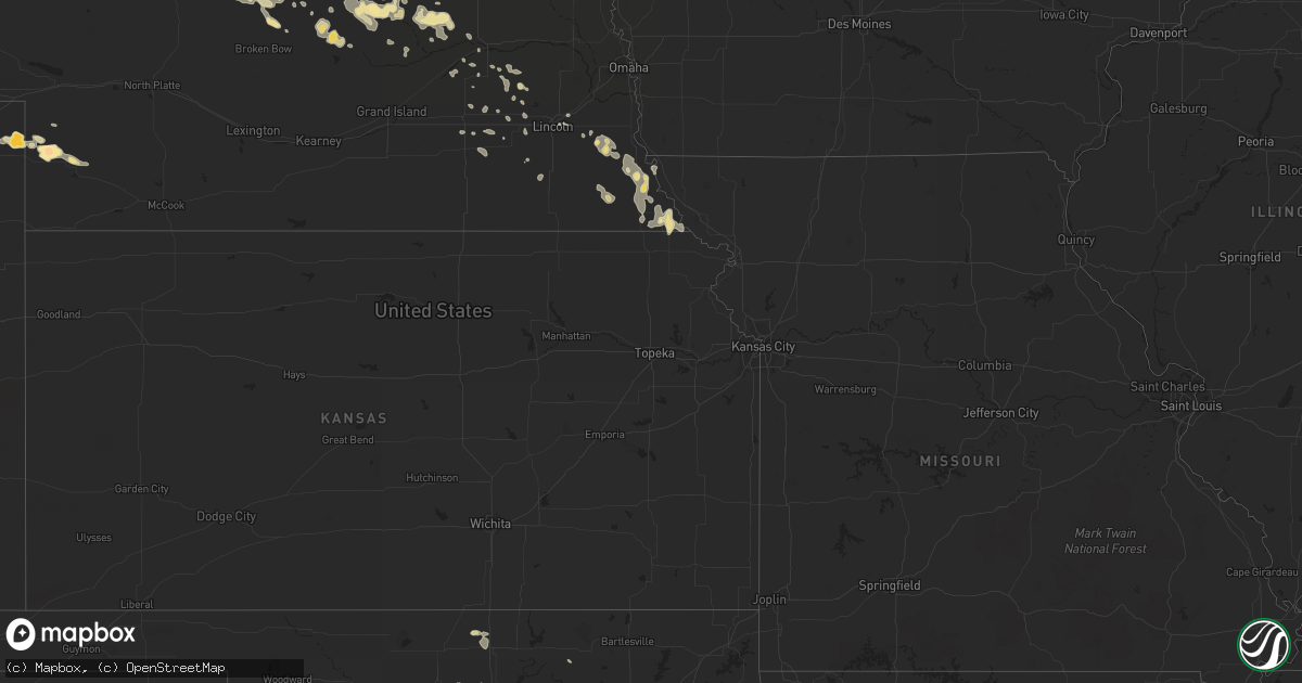
Hail Map in North Carolina on August 11, 2011
Get this storm
August 11 map
$229
one time, instant access
Download today. No call, no setup
Keep the $229
Bought the map and want the full workflow? Apply the entire $229 to a subscription within 7 days. None of it is wasted.
Every map, not just this one
This buys you this map. Subscription and you get every map we run, in the markets you choose from a few cities to whole states to nationwide. Plus real-time alerts the moment a storm fires.
Contact data
Name, contact info, occupancy, even credit band for addresses in the footprint. You go from where it hit to who to call.
Become the source they trust
Unlimited branding weather history reports on demand. You already have the documented answer ready for the property owner, and you are the one who showed up with it.
Property data and RoofTrace estimates
Pull up any address you have got, its value and the exact code rules for that jurisdiction, straight from One Click Code. Then RoofTrace estimates the squares, pitch, and roof value, priced the way you price.
Storm reports in North Carolina
North Carolina
| Date | Description |
|---|---|
| 08/11/20115:12 PM CDT | Trees down on pleasant grove road. |
| 08/11/20115:00 PM CDT | Large tree on road. |
| 08/11/20115:00 PM CDT | A few trees down in water oak area. |
| 08/11/20114:55 PM CDT | County reports a structure moved off its foundation by wind gusts at abby walk lane near mckee road. |
| 08/11/20114:30 PM CDT | Quarter size hail on south blvd in charlotte. |
| 08/11/20114:20 PM CDT | Debris in roadway from winds at yorkmont and billy graham parkway near charlotte airport. |
| 08/11/20114:13 PM CDT | Measured 50 kt gust at clt airport. |
| 08/11/20114:08 PM CDT | A few large limbs down along with the large hail. |
| 08/11/20114:08 PM CDT | Half dollar sized hail falling just outside of belmont. |
| 08/11/20114:00 PM CDT | Spotter reports quarter size hail along hickory grove road. |
| 08/11/20113:40 PM CDT | Spotter took a photograph of approaching storm at fire department which verified this time. Several large limbs were downed from this storm as it went through the area. |
| 08/11/20113:32 PM CDT | Several trees down in and around dallas...2 trees that fell on separate houses...and several other trees either down or snapped off about half way up the tree. |
| 08/11/20113:26 PM CDT | Six aircraft damaged and one tree down at kjqf concord regional airport. |
| 08/11/20113:18 PM CDT | Trees and power lines down along old statesville road. |
| 08/11/20113:15 PM CDT | Trees and power lines down along bethel church road. |
| 08/11/20113:10 PM CDT | Davidson p.d. Reports 10 to 15 trees blown down or topped by wind along main street. Rail fence leveled by wind as well. |
| 08/11/20113:06 PM CDT | Several large limbs and at least one pine tree down along with some powerlines down in davidson. The time was obtained from doppler velocity data as the wind max crosse |
| 08/11/20111:56 PM CDT | At least one large tree down in the davie academy road area along with several other large branches. This location is just south of interstate 40. |
| 08/11/20111:49 PM CDT | Two trees down on hwy 10 in between casar and toluca. |
| 08/11/201112:54 PM CDT | Quarter size hail near hwy 321-a and connelly springs rd. |
| 08/11/201112:51 PM CDT | Tree down |
| 08/11/201112:40 PM CDT | 3 trees down |
All States Impacted by Hail Map on August 11, 2011
Cities Impacted by Hail Map on August 11, 2011
- Buffalo, SD
- Genoa, CO
- Brundidge, AL
- Hardin, MT
- Crow Agency, MT
- Nazareth, TX
- Dimmitt, TX
- Stuart, NE
- Imperial, NE
- Springview, NE
- Mills, NE
- Decker, MT
- Nocona, TX
- Cobb, GA
- De Soto, GA
- Warwick, GA
- Cordele, GA
- Merriman, NE
- Gordon, NE
- Ainsworth, NE
- Bassett, NE
- Colome, SD
- Dallas, SD
- Fairburn, SD
- Hermosa, SD
- Pine Ridge, SD
- Purdum, NE
- Brewster, NE
- Rio Medina, TX
- Belle Fourche, SD
- Del Rio, TX
- Hammond, MT
- Ekalaka, MT
- Rattan, OK
- Whiteface, TX
- Gregory, SD
- Weston, WY
- Malta, MT
- Zortman, MT
- Rapid City, SD
- Ord, NE
- Havre, MT
- Camp Crook, SD
- Chamberlain, SD
- House, NM
- Brantley, AL
- Greenville, AL
- Holabird, SD
- Highmore, SD
- Pine Mountain, GA
- Beulah, WY
- Sundance, WY
- Cassatt, SC
- Bethune, SC
- Kershaw, SC
- Healdton, OK
- Graham, OK
- Braddock, ND
- Saint Francis, SD
- Midland, SD
- Cherry Creek, SD
- Milesville, SD
- Valentine, NE
- Hinsdale, MT
- Joliet, MT
- Erskine, MN
- Mentor, MN
- Lead, SD
- Silver City, NM
- Draper, SD
- Cooperstown, ND
- Marshall, OK
- Crescent, OK
- Rocksprings, TX
- Muleshoe, TX
- Sonora, TX
- Geary, OK
- Cody, NE
- Murdo, SD
- Okaton, SD
- Sacramento, NM
- Kennebec, SD
- Wood Lake, NE
- Belmont, NC
- Kit Carson, CO
- Okreek, SD
- Mission, SD
- Saco, MT
- Kingfisher, OK
- Clyde, TX
- Ree Heights, SD
- Gastonia, NC
- Dorchester, SC
- Perry, OK
- Plains, TX
- Deer Creek, OK
- Steele, ND
- Grant, NE
- Sheridan Lake, CO
- Vale, SD
- Plankinton, SD
- Harrold, SD
- Onida, SD
- Brock, NE
- Hayes, SD
- Terry, MT
- Falls City, NE
- Wessington Springs, SD
- Granite Falls, NC
- Hudson, NC
- Lenoir, NC
- Brackettville, TX
- Uvalde, TX
- Kilgore, NE
- Nenzel, NE
- Menno, SD
- Lesterville, SD
- Tulia, TX
- Lodge Grass, MT
- North Loup, NE
- Lloyd, MT
- Union, SC
- Boyd, TX
- Paradise, TX
- Eads, CO
- Wiley, CO
- Seward, NE
- Fort Pierre, SD
- Baker, MT
- Sargent, NE
- Anselmo, NE
- Taylor, NE
- Oshkosh, NE
- Saint Edward, NE
- Albion, NE
- Newman Grove, NE
- Fairmont, OK
- Niobrara, NE
- Springfield, SD
- Royal, NE
- Orchard, NE
- Winnetoon, NE
- Millersview, TX
- Broadus, MT
- Harleyville, SC
- Bowman, SC
- Saint George, SC
- Broken Bow, NE
- Perryton, TX
- Amherst, CO
- Thompson, ND
- Wakefield, NE
- Long Pine, NE
- Fort Towson, OK
- Sawyer, OK
- Winnett, MT
- Creighton, NE
- Arthur City, TX
- Paris, TX
- Detroit, TX
- Hugo, OK
- Roberts, MT
- Eastpoint, FL
- Clewiston, FL
- Nemo, SD
- Deadwood, SD
- Otter, MT
- Miller, SD
- Rush Springs, OK
- West Fork, AR
- Forestburg, TX
- Gaston, SC
- Saint Lawrence, SD
- Albany, GA
- Huntersville, NC
- Concord, NC
- Mauk, GA
- Box Springs, GA
- Junction City, GA
- Naper, NE
- Hennessey, OK
- Padroni, CO
- Hugo, CO
- Alvord, TX
- Chico, TX
- Harlem, MT
- Forsyth, MT
- Snow, OK
- Clayton, OK
- Marlow, OK
- Duncan, OK
- Snyder, TX
- Rotan, TX
- Hermleigh, TX
- Chauncey, GA
- Eastman, GA
- Milan, GA
- Burwell, NE
- Brainard, NE
- David City, NE
- Tilden, NE
- Blunt, SD
- Venango, NE
- Holyoke, CO
- Ideal, SD
- White River, SD
- Wood, SD
- Grand Forks, ND
- Primrose, NE
- Spalding, NE
- Auburn, NE
- Nemaha, NE
- Brownville, NE
- Unadilla, NE
- Verdigre, NE
- Regan, ND
- Ryan, OK
- Oneill, NE
- Burke, SD
- Wolbach, NE
- Washburn, ND
- Aladdin, WY
- Seibert, CO
- Lubbock, TX
- Lindsay, OK
- Bradley, OK
- Blanchard, OK
- Alex, OK
- Columbus, MT
- Willacoochee, GA
- Kress, TX
- Enders, NE
- Broxton, GA
- Hopkins, SC
- Eastover, SC
- Gadsden, SC
- Plainview, TX
- Olton, TX
- Crosby, ND
- Genoa, NE
- Baldwin, ND
- Fallon, MT
- Littlefield, TX
- Charlotte, NC
- Pompeys Pillar, MT
- Ballantine, MT
- Presho, SD
- Hays, MT
- Hartsville, SC
- Comanche, OK
- Bridgeport, TX
- Cedar Rapids, NE
- Lindsay, NE
- McCool Junction, NE
- Sweetwater, TX
- Lincoln, NE
- Champion, NE
- Minco, OK
- Peru, NE
- Watson, MO
- Platte, SD
- Hart, TX
- Midland, GA
- Lamar, CO
- Dadeville, AL
- Canyon, TX
- Happy, TX
- Oregon, MO
- Muscle Shoals, AL
- Okarche, OK
- Johnstown, NE
- Elsmere, NE
- Thedford, NE
- Silver Creek, NE
- Osceola, NE
- Utopia, TX
- Fedora, SD
- Artesian, SD
- Immokalee, FL
- Sedgwick, CO
- Halsey, NE
- Lower Brule, SD
- Lancaster, KS
- Everest, KS
- Eclectic, AL
- Kintyre, ND
- Swansea, SC
- Meridian, OK
- Dunbar, NE
- Otoe, NE
- Syracuse, NE
- Talmage, NE
- Roanoke, AL
- Woodland, AL
- Wedowee, AL
- Alamo, ND
- Panama City, FL
- Hondo, TX
- Dunning, NE
- Hitchcock, SD
- Wolsey, SD
- Scotland, SD
- Tyndall, SD
- Greeley, NE
- Scotia, NE
- Stromsburg, NE
- Crestview, FL
- Odonnell, TX
- Brunswick, NE
- Haxtun, CO
- Lynch, NE
- Hasty, CO
- McClave, CO
- Lance Creek, WY
- Hamilton, GA
- Ratliff City, OK
- Loco, OK
- Ringling, OK
- Saint Jo, TX
- Wilson, OK
- Springer, OK
- Spencer, NE
- Laurel, MT
- Avon, SD
- Wagner, SD
- Montague, TX
- Loring, MT
- Hulett, WY
- Pierre, SD
- Ambrose, GA
- Pukwana, SD
- Amelia, NE
- Waterloo, SC
- Arcadia, NE
- Cadwell, GA
- McRae Helena, GA
- Taiban, NM
- Roff, OK
- Winner, SD
- Buckhorn, NM
- Page, NE
- Watonga, OK
- Calumet, OK
- Greenfield, OK
- Driscoll, ND
- Exeter, NE
- Denton, KS
- Mott, ND
- White Lake, SD
- Waukomis, OK
- Bison, OK
- West Green, GA
- Sudan, TX
- McBee, SC
- Saint Xavier, MT
- Chickasha, OK
- Wilsall, MT
- Elgin, SC
- Blythewood, SC
- Upatoi, GA
- Earth, TX
- Cullman, AL
- Wayne, OK
- Purcell, OK
- Chinook, MT
- Neligh, NE
- Whitmire, SC
- El Reno, OK
- Wadley, AL
- Lafayette, AL
- Alapaha, GA
- Hennepin, OK
- Ringgold, TX
- Davis, OK
- Flagler, CO
- Maysville, OK
- Nicholls, GA
- Sulphur, OK
- Lagrange, GA
- West Point, GA
- Las Animas, CO
- Steinauer, NE
- Elk Creek, NE
- Lowell, NC
- Mount Holly, NC
- McAdenville, NC
- Moffit, ND
- Brockway, MT
- Springtown, TX
- Decatur, TX
- Battle Creek, NE
- Rayville, MO
- Richmond, MO
- Paoli, OK
- Pauls Valley, OK
- Wing, ND
- Defuniak Springs, FL
- Mico, TX
- San Antonio, TX
- Mountainburg, AR
- Winslow, AR
- Lawndale, NC
- Connelly Springs, NC
- Casar, NC
- Birney, MT
- Nardin, OK
- Blackwell, OK
- Alzada, MT
- Roscoe, TX
- Loraine, TX
- Freeport, FL
- Elgin, NE
- Clearwater, NE
- Petersburg, NE
- Dallas, NC
- Cramerton, NC
- Notasulga, AL
- Bloomfield, NE
- Rhine, GA
- Hillsboro, ND
- Antlers, OK
- Vona, CO
- Ashville, AL
- Bowie, TX
- Sunset, TX
- Cohagen, MT
- Putnam, OK
- Belvidere, SD
- Grant, OK
- Norman, OK
- Underwood, ND
- Hereford, TX
- Marion, SC
- Doerun, GA
- Zahl, ND
- Capitan, NM
- Monroe, NE
- Platte Center, NE
- West Columbia, SC
- Colorado City, TX
- Amber, OK
- Tuttle, OK
- Piedmont, OK
- Waco, NE
- Rushville, NE
- Lame Deer, MT
- Talihina, OK
- Muse, OK
- Whitesboro, OK
- Cragford, AL
- Daviston, AL
- Dwight, NE
- Caryville, FL
- Vernon, FL
- Franklin, GA
- Cookson, OK
- York, NE
- Shelby, NE
- Verden, OK
- Hawkinsville, GA
- Pineview, GA
- Waverly, NE
- Garland, NE
- Pleasant Dale, NE
- Camp Hill, AL
- Foster, OK
- Bagwell, TX
- Dozier, AL
- Eden, TX
- Wray, GA
- Butte, NE
- Junction, TX
- Wolf Point, MT
- Billings, MT
- Lamesa, TX
- Utica, NE
- Ebro, FL
- Table Rock, NE
- Tecumseh, NE
- Altoona, AL
- Martin, SD
- Killen, AL
- Town Creek, AL
- Edgemont, SD
- Ashland, AL
- Matthews, NC
- Rulo, NE
- Hiawatha, KS
- Wilber, NE
- Union City, OK
- Douglas, GA
- Spearfish, SD
- Bartlett, NE
- Wyola, MT
- Gann Valley, SD
- Chambers, NE
- Newport, NE
- Utica, SD
- Douglas, OK
- Herrick, SD
- Bonesteel, SD
- Atkinson, NE
- Rising City, NE
- Reliance, SD
- Coleman, OK
- McLaughlin, SD
- New Holland, SD
- Corsica, SD
- Harrison, SD
- Oacoma, SD
- Jasper, AL
- Spencer, SD
- Ewing, NE
- Arley, AL
- Russellville, AL
- Leighton, AL
- Tuskahoma, OK
- Tallassee, AL
- Clearmont, WY
- Sheridan, WY
- Moulton, AL
- Camden, SC
- Trinidad, CO
- Lexington, OK
- Kinsey, MT
- Bee, NE
- Fort Mill, SC
- Lynn Haven, FL
- Columbia, SC
- Sweet Grass, MT
- Cleveland, OK
- Cashion, OK
- Amidon, ND
- Philip, SD
- Concan, TX
- Jacksonville, GA
- Montezuma, GA
- Baker, FL
- Andersonville, GA
- Oglethorpe, GA
- Guthrie, OK
- Seminole, OK
- Bunch, OK
- Wauneta, NE
- Nashua, MT
- Springville, AL
- Darlington, SC
- Tryon, OK
- Clover, SC
- Patrick, SC
- Jefferson, SC
- Hitchcock, OK
- Sparks, NE
- Olivet, SD
- Lamont, OK
- Tonkawa, OK
- Dixon, NE
- Concord, NE
- Allen, NE
- Emerson, NE
- Wessington, SD
- Ardmore, OK
- Waurika, OK
- Tabor, SD
- Ocilla, GA
- Barksdale, TX
- Tripp, SD
- Julian, NE
- Nebraska City, NE
- Shubert, NE
- Johnson, NE
- Dawson, NE
- Humboldt, NE
- Verdon, NE
- Stella, NE
- Stanley, NC
- Wanette, OK
- Julesburg, CO
- Belgrade, NE
- Palmer, NE
- Woonsocket, SD
- Clayton, AL
- Laurel Hill, FL
- Hamill, SD
- Carrollton, MO
- Ulysses, NE
- Circle, MT
- Ramah, CO
- Matheson, CO
- Comstock, NE
- Plainview, NE
- Wynnewood, OK
- Milford, NE
- Leslie, GA
- Morton, TX
- De Witt, NE
- Elmore City, OK
- Waycross, GA
- Lindsay, MT
- Otis, CO
- Clatonia, NE
- Wewahitchka, FL
- Canute, OK
- Bessemer City, NC
- Double Springs, AL
- Houston, AL
- Parkston, SD
- Aberdeen, MS
- Regent, ND
- Abbeville, GA
- Craig, MO
- Ericson, NE
- Arriba, CO
- Fairfax, OK
- Florence, SC
- White Cloud, KS
- Salem, NE
- Dorchester, NE
- Beaver Crossing, NE
- Valliant, OK
- Meigs, GA
- Cornelius, NC
- Davidson, NC
- Pocasset, OK
- Fortson, GA
- Columbus, GA
- Laughlin Afb, TX
- Yukon, OK
- Columbus, NE
- Maud, OK
- Lugoff, SC
- Enochs, TX
- Glasgow, MT
- Sturgis, SD
- Chandler, OK
- Carney, OK
- Wellston, OK
- Kings Mountain, NC
- Hazlehurst, GA
- Ninnekah, OK
- Enid, OK
- Ridgeway, SC
- Troy, AL
- Crete, NE
- Bristow, NE
- Laurel, NE
- Leedey, OK
- Butler, OK
- Palmyra, NE


