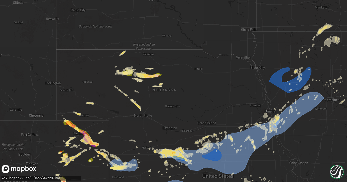
Hail Map in Nebraska on August 9, 2025
Get this storm
August 9 map
$229
one time, instant access
Download today. No call, no setup
Keep the $229
Bought the map and want the full workflow? Apply the entire $229 to a subscription within 7 days. None of it is wasted.
Every map, not just this one
This buys you this map. Subscription and you get every map we run, in the markets you choose from a few cities to whole states to nationwide. Plus real-time alerts the moment a storm fires.
Contact data
Name, contact info, occupancy, even credit band for addresses in the footprint. You go from where it hit to who to call.
Become the source they trust
Unlimited branding weather history reports on demand. You already have the documented answer ready for the property owner, and you are the one who showed up with it.
Property data and RoofTrace estimates
Pull up any address you have got, its value and the exact code rules for that jurisdiction, straight from One Click Code. Then RoofTrace estimates the squares, pitch, and roof value, priced the way you price.
Storm reports in Nebraska
Nebraska
| Date | Description |
|---|---|
| 08/09/20255:18 PM CDT | Golf ball size hail and 57 mph winds. |
| 08/09/20257:15 AM CDT | Public report relayed via social media of large trees down. Time estimated from radar. |
| 08/09/20253:10 AM CDT | Awos reported 90 mph gust prior to going offline. Damage to sheds at airport. |
| 08/09/20253:04 AM CDT | Grain bin and shed damaged. |
| 08/09/20252:56 AM CDT | Gust measured from a public mesonet site. |
| 08/09/20252:40 AM CDT | Delayed report of extensive roof damage to two buildings. Time estimated from radar. |
| 08/09/20252:40 AM CDT | Emergency manager reported 6-8 inch tree limbs broken. Time estimated by radar. |
| 08/09/20252:35 AM CDT | A local report indicates 60 MPH wind near 3 WNW Bennet |
| 08/09/20252:34 AM CDT | Measured from public mesonet station. |
| 08/09/20251:50 AM CDT | Measured from a public mesonet station. |
| 08/09/20251:48 AM CDT | Significant damage to a large grain bin. Time estimated by radar. |
| 08/09/20251:48 AM CDT | A local report indicates 62 MPH wind near 6 WNW Fairbury |
| 08/09/20251:45 AM CDT | Davis weather station. Continued severe winds behind main line. |
| 08/09/20251:40 AM CDT | A local report indicates 64 MPH wind near 4 NNW Ohiowa |
| 08/09/20251:33 AM CDT | A local report indicates 72 MPH wind near 3 S Ohiowa |
| 08/09/20251:30 AM CDT | A local report indicates 61 MPH wind near 3 S Ohiowa |
| 08/09/20251:30 AM CDT | A local report indicates 62 MPH wind near 3 ESE Carleton |
| 08/09/20251:30 AM CDT | A local report indicates 63 MPH wind near 2 WSW Bruning |
| 08/09/20251:29 AM CDT | Power pole down with power outage. Time estimated by radar. |
| 08/09/20251:22 AM CDT | Spotter reports multiple trees down in bruning blocking roads. Time estimated from radar. |
| 08/09/20251:21 AM CDT | A local report indicates 63 MPH wind near 2 WSW Bruning |
| 08/09/20251:18 AM CDT | Snapped trees and large branches down in town. |
| 08/09/20251:15 AM CDT | Davis weather station. |
| 08/09/20251:15 AM CDT | Davis weather station. Continued severe gusts behind the stronger push of winds. |
| 08/09/20251:15 AM CDT | A local report indicates 85 MPH wind near 4 ESE Davenport |
| 08/09/20251:14 AM CDT | A local report indicates 60 MPH wind near 3 N Chester |
| 08/09/20251:14 AM CDT | A local report indicates 61 MPH wind near 3 ESE Carleton |
| 08/09/20251:10 AM CDT | A local report indicates 69 MPH wind near 3 S Carleton |
| 08/09/20251:10 AM CDT | A local report indicates 59 MPH wind near 1 SW Carleton |
| 08/09/20251:09 AM CDT | A local report indicates 62 MPH wind near 4 E Hebron |
| 08/09/20251:08 AM CDT | Pws station knecarle5. Station stopped reporting at this time and peak wind may have been higher. |
| 08/09/20251:07 AM CDT | Davis weather station. |
| 08/09/20251:07 AM CDT | A local report indicates 61 MPH wind near 4 SSW Carleton |
| 08/09/20251:06 AM CDT | 55 yr old blue spruce tree blown over. Report via facebook. Time estimated from radar. |
| 08/09/20251:06 AM CDT | Delayed report. Em reports more than 30 power poles destroyed across thayer county with numerous along highway 5 between carleton and davenport. Time estimated from ini |
| 08/09/20251:06 AM CDT | A local report indicates 67 MPH wind near 3 SW Carleton |
| 08/09/20251:05 AM CDT | Several large trees downed. |
| 08/09/202512:59 AM CDT | A local report indicates 83 MPH wind near 4 NW Deshler |
| 08/09/202512:58 AM CDT | A local report indicates 65 MPH wind near 4 ENE Ruskin |
| 08/09/202512:54 AM CDT | Davis weather station. Station stopped reporting at this time. Peak gust likely higher. |
| 08/09/202512:51 AM CDT | Davis weather station. |
| 08/09/202512:50 AM CDT | A local report indicates 67 MPH wind near Ruskin |
| 08/09/202512:50 AM CDT | Delayed report. Em reports multiple fields flattened near deshler... Multiple fields stripped. Time estimated of initial wind surge from radar. |
| 08/09/202512:50 AM CDT | Delayed report. Em reported damage to roof on homestead... Multiple out buildings destroyed. Time of initial surge of winds estimated from radar. |
| 08/09/202512:50 AM CDT | Delayed report. Em reports large cinderblock wall blown down from initial surge of winds at south central irrigation in deshler. Time estimated from radar. |
| 08/09/202512:50 AM CDT | Delayed report. Em reports full size barn relocated |
| 08/09/202512:50 AM CDT | Delayed report. Em reports multiple large trees in the town of deshler blown down with branches as large as 2 feet in diameter broken off healthy trees. Time of initial |
| 08/09/202512:50 AM CDT | Davis weather station. Station stopped reporting shortly after this. |
| 08/09/202512:45 AM CDT | Delayed... Estimated report of 90 mph winds in superior. Time estimated based on surrounding weather station observations. |
| 08/09/202512:42 AM CDT | A local report indicates 58 MPH wind near 6 NW Nelson |
| 08/09/202512:39 AM CDT | A local report indicates 66 MPH wind near 2 NNW Superior |
| 08/09/202512:34 AM CDT | A local report indicates 58 MPH wind near 7 WSW Nelson |
| 08/09/202512:31 AM CDT | Tempest weather station. |
| 08/09/202512:27 AM CDT | 2 meter wind from nebraska mesonet station. |
| 08/08/202511:04 PM CDT | A local report indicates 61 MPH wind near 3 W Republican City |
| 08/08/20257:37 PM CDT | Law enforcement estimated 1 inch hail 45-50 mph winds in haigler. |
All States Impacted by Hail Map on August 9, 2025
Cities Impacted by Hail Map on August 9, 2025
- Charter Oak, IA
- Manilla, IA
- Defiance, IA
- Mapleton, IA
- Deloit, IA
- Arion, IA
- Onawa, IA
- Schleswig, IA
- Denison, IA
- Dunlap, IA
- Soldier, IA
- Irwin, IA
- Dow City, IA
- Ute, IA
- Kirkman, IA
- Vail, IA
- Earling, IA
- Castana, IA
- Rodney, IA
- Ricketts, IA
- Smithland, IA
- Battle Creek, IA
- Kiron, IA
- Manning, IA
- Audubon, IA
- Altamont, MO
- Independence, WI
- Bancroft, IA
- Arcadia, WI
- Zumbrota, MN
- Pine Island, MN
- Dorchester, WI
- Medford, WI
- Withee, WI
- Lake View, IA
- Sac City, IA
- Swea City, IA
- Ledyard, IA
- Lakota, IA
- Greenwood, WI
- Elmore, MN
- Buffalo Center, IA
- Blue Earth, MN
- Whitehall, WI
- Osseo, WI
- Curtiss, WI
- Mazeppa, MN
- Wall Lake, IA
- Aspinwall, IA
- Templeton, IA
- Carroll, IA
- Halbur, IA
- Westside, IA
- Dedham, IA
- Arcadia, IA
- Gray, IA
- Zumbro Falls, MN
- Lake City, MN
- Lytton, IA
- Stetsonville, WI
- Millville, MN
- Bricelyn, MN
- Frost, MN
- Auburn, IA
- Owen, WI
- Fountain City, WI
- Winston, MO
- Glidden, IA
- Breda, IA
- Lidderdale, IA
- Oto, IA
- Danbury, IA
- Ida Grove, IA
- Holstein, IA
- Anthon, IA
- Correctionville, IA
- Cushing, IA
- Churdan, IA
- Lake City, IA
- Havelock, IA
- Dodge Center, MN
- Hayfield, MN
- Blooming Prairie, MN
- Taylor, WI
- Kidder, MO
- Laurens, IA
- Wells, MN
- Wabasha, MN
- Cochrane, WI
- Kellogg, MN
- Kiester, MN
- Rockwell City, IA
- Jolley, IA
- Scranton, IA
- Ralston, IA
- Coon Rapids, IA
- Lohrville, IA
- Lanesboro, IA
- Mallard, IA
- Athens, WI
- Edgar, WI
- Alden, MN
- Hixton, WI
- Black River Falls, WI
- Pomeroy, IA
- Kasson, MN
- Alma, WI
- Manson, IA
- Somers, IA
- Farnhamville, IA
- Blair, WI
- Conover, WI
- Whittemore, IA
- Algona, IA
- West Bend, IA
- Lyle, MN
- Rose Creek, MN
- Oronoco, MN
- Rolfe, IA
- Knierim, IA
- Galesville, WI
- Mantorville, MN
- Curlew, IA
- Moorland, IA
- Callender, IA
- Gowrie, IA
- Barnum, IA
- Sargeant, MN
- Dexter, MN
- Brownsdale, MN
- Austin, MN
- Waltham, MN
- Eagle River, WI
- Three Lakes, WI
- Britt, IA
- Minnesota City, MN
- Mosinee, WI
- Lone Rock, IA
- Emmetsburg, IA
- Hatley, WI
- Burt, IA
- Ettrick, WI
- Woden, IA
- Crystal Lake, IA
- Forest City, IA
- Corwith, IA
- Schofield, WI
- Byron, MN
- Rochester, MN
- Clear Lake, IA
- Ventura, IA
- Stewartville, MN
- Spring Valley, MN
- Garner, IA
- Wesley, IA
- Joice, IA
- Lake Mills, IA
- Grand Meadow, MN
- Racine, MN
- Leland, IA
- Hanlontown, IA
- Fertile, IA
- Elkton, MN
- Adams, MN
- Chatfield, MN
- Mason City, IA
- Eyota, MN
- Wykoff, MN
- Dover, MN
- Manly, IA
- Wisconsin Rapids, WI
- Kensett, IA
- Saint Ansgar, IA
- Saint Charles, MN
- Plainview, MN
- Elgin, MN
- Cumberland, IA
- Stevens Point, WI
- Rudolph, WI
- Massena, IA
- Junction City, WI
- Milladore, WI
- Altura, MN
- Trempealeau, WI
- Riceville, IA
- Winona, MN
- Dakota, MN
- Houston, MN
- Rollingstone, MN
- De Soto, WI
- Viroqua, WI
- Coon Valley, WI
- Stoddard, WI
- Chaseburg, WI
- Westby, WI
- Cashton, WI
- La Farge, WI
- Ontario, WI
- Norwalk, WI
- Hillsboro, WI
- Kendall, WI
- Sterlington, LA
- Green Bay, WI
- West Monroe, LA
- Poynette, WI
- Denmark, WI
- De Pere, WI
- New Franken, WI
- Ogdensburg, WI
- Scandinavia, WI
- Waupaca, WI
- Portage, WI
- Luxemburg, WI
- Iola, WI
- Manawa, WI
- New London, WI
- Bear Creek, WI
- Weyauwega, WI
- Clintonville, WI
- Broadwater, NE
- Downing, MO
- Casco, WI
- Omro, WI
- Shiocton, WI
- Columbus, WI
- Appleton, WI
- Black Creek, WI
- Sun Prairie, WI
- Bushnell, NE
- Kaukauna, WI
- Algoma, WI
- Sturgeon Bay, WI
- Forestville, WI
- Bonduel, WI
- Merriman, NE
- Kimball, NE
- Seymour, WI
- Jonesboro, LA
- New Raymer, CO
- Glenbeulah, WI
- Green Castle, MO
- Novinger, MO
- Kewaunee, WI
- Kiel, WI
- Padroni, CO
- Stoneham, CO
- Elkhart Lake, WI
- Agate, CO
- Valders, WI
- New Holstein, WI
- Maribel, WI
- Hartford, WI
- Menominee, MI
- Juneau, WI
- West Bend, WI
- Marshall, WI
- Dix, NE
- Potter, NE
- Wiggins, CO
- Fort Morgan, CO
- Merino, CO
- Whitman, NE
- Deer Trail, CO
- Sidney, NE
- Kewaskum, WI
- Sterling, CO
- Valentine, NE
- Woodrow, CO
- Iliff, CO
- Fleming, CO
- Limon, CO
- Donnellson, IA
- Farmington, IA
- Cedarburg, WI
- Slinger, WI
- Elizabeth, CO
- Kiowa, CO
- Grafton, WI
- Marengo, IL
- Akron, CO
- Lindon, CO
- Matheson, CO
- Sussex, WI
- Woodstock, IL
- Lannon, WI
- Menomonee Falls, WI
- Pewaukee, WI
- Waukesha, WI
- Brookfield, MO
- Bucklin, MO
- Kim, CO
- Thedford, NE
- Otis, CO
- Haxtun, CO
- Cody, NE
- Brookfield, WI
- Milwaukee, WI
- Mequon, WI
- Gibbs, MO
- Brashear, MO
- La Plata, MO
- Elfrida, AZ
- Sugar Land, TX
- Yuma, CO
- Brookshire, TX
- Ethel, MO
- New Cambria, MO
- Katy, TX
- Wood Lake, NE
- Pritchett, CO
- Hugo, CO
- Johnstown, NE
- Elsmere, NE
- Callao, MO
- Elmer, MO
- Novelty, MO
- Hurdland, MO
- Macon, MO
- Atlanta, MO
- Patagonia, AZ
- Nogales, AZ
- Snyder, CO
- Bellville, TX
- Eagle Lake, TX
- East Bernard, TX
- Oak Creek, WI
- Sublette, IL
- La Moille, IL
- Mendota, IL
- Chappell Hill, TX
- Leonard, MO
- Anabel, MO
- Clarence, MO
- Brush, CO
- Ramah, CO
- Eckley, CO
- Halsey, NE
- McNeal, AZ
- Shelbyville, MO
- Columbus, TX
- Bethel, MO
- Newark, MO
- New Berlin, WI
- Purdum, NE
- Compton, IL
- Wray, CO
- Steward, IL
- Paw Paw, IL
- New Ulm, TX
- Atwood, CO
- Bisbee, AZ
- Dekalb, IL
- La Belle, MO
- Hubertus, WI
- Richfield, WI
- Jackson, WI
- Holyoke, CO
- Paoli, CO
- Emden, MO
- Ewing, MO
- Hereford, AZ
- Philadelphia, MO
- Genoa, IL
- Karval, CO
- Big Bend, WI
- Muskego, WI
- Saint Francis, KS
- Haigler, NE
- Vernon, CO
- Hayes Center, NE
- Simla, CO
- Palmyra, MO
- Maywood, MO
- Durham, MO
- Taylor, MO
- Elkhorn, WI
- Deerfield, WI
- Idalia, CO
- Palisade, NE
- Hales Corners, WI
- Mukwonago, WI
- Mullen, NE
- Franklin, WI
- Delafield, WI
- Oconomowoc, WI
- Wales, WI
- Dousman, WI
- East Troy, WI
- Calhan, CO
- Curtis, NE
- Eagle, WI
- Goodland, KS
- Trenton, NE
- Peyton, CO
- Yoder, CO
- Hillrose, CO
- Pearce, AZ
- North Prairie, WI
- Bird City, KS
- Edson, KS
- Colorado Springs, CO
- Rush, CO
- McCook, NE
- Culbertson, NE
- McDonald, KS
- Colby, KS
- Indianola, NE
- Danbury, NE
- Orangeville, IL
- Juda, WI
- Lebanon, NE
- Elm Grove, WI
- Butler, WI
- Levant, KS
- Atwood, KS
- Rock City, IL
- Brodhead, WI
- Brady, NE
- Wilsonville, NE
- Ordway, CO
- Fountain, CO
- Beaver City, NE
- Arapahoe, NE
- Hendley, NE
- Ludell, KS
- Norcatur, KS
- Boone, CO
- Reeseville, WI
- Stamford, NE
- Orleans, NE
- Norton, KS
- Hyannis, NE
- Lake Geneva, WI
- Sugar City, CO
- Almena, KS
- Long Island, KS
- Oxford, NE
- Alma, NE
- Burlington, WI
- Kansasville, WI
- Edison, NE
- Edgerton, WI
- Olney Springs, CO
- Prairie View, KS
- Phillipsburg, KS
- Johnson Creek, WI
- Fort Atkinson, WI
- Stoughton, WI
- Madison, WI
- Palmyra, WI
- Whitewater, WI
- Waterford, WI
- Helenville, WI
- Cottage Grove, WI
- Mcfarland, WI
- Lenora, KS
- Selden, KS
- Watertown, WI
- Jefferson, WI
- Arlington, CO
- Agra, KS
- Republican City, NE
- Hill City, KS
- Morland, KS
- Fairbury, NE
- Logan, KS
- Eads, CO
- Haswell, CO
- Roseland, NE
- Inland, NE
- Hastings, NE
- Glenvil, NE
- Ayr, NE
- Kensington, KS
- Kirwin, KS
- Naponee, NE
- Penrose, CO
- Holstein, NE
- Campbell, NE
- Cedar, KS
- Gaylord, KS
- Riverton, NE
- Franklin, NE
- Bloomington, NE
- Smith Center, KS
- Athol, KS
- Alton, KS
- Pueblo, CO
- Bogue, KS
- Waunakee, WI
- Deforest, WI
- Bladen, NE
- Nelson, NE
- Superior, NE
- Hardy, NE
- Harvard, NE
- Saronville, NE
- Clay Center, NE
- Osborne, KS
- Portis, KS
- Red Cloud, NE
- Inavale, NE
- Lebanon, KS
- Windsor, WI
- Liberty, NE
- Arthur, NE
- Tryon, NE
- Virginia, NE
- Minden, NE
- Blue Springs, NE
- Sheridan Lake, CO
- Oak, NE
- Lawrence, NE
- Blue Hill, NE
- Abbotsford, WI
- Plainville, KS
- Dodge, WI
- Strum, WI
- Davenport, NE
- Ohiowa, NE
- Tobias, NE
- Elma, IA
- Beatrice, NE
- Carleton, NE
- Thompson, IA
- Lansing, IA
- Guide Rock, NE
- Deweese, NE
- Filley, NE
- Pepin, WI
- La Junta, CO
- Downs, KS
- Mankato, KS
- Burr Oak, KS
- Esbon, KS
- Avondale, CO
- Stockton, KS
- Sullivan, WI
- Racine, WI
- Lamar, CO
- Edgar, NE
- Wiley, CO
- Sutherland, NE
- Alexandria, NE
- Daykin, NE
- Plymouth, NE
- Jansen, NE
- Sutton, NE
- Randall, KS
- Jewell, KS
- Formoso, KS
- Webber, KS
- Fowler, CO
- Fairfield, NE
- Pickrell, NE
- Milligan, NE
- Ong, NE
- Elmwood, NE
- Tecumseh, NE
- De Witt, NE
- Holly, CO
- Beaver Crossing, NE
- Adams, NE
- Grafton, NE
- Cook, NE
- Seward, NE
- Milford, NE
- Tribune, KS
- Scandia, KS
- Norway, KS
- Jamestown, KS
- Beloit, KS
- Courtland, KS
- Belleville, KS
- Concordia, KS
- Republic, KS
- Chester, NE
- Hebron, NE
- Byron, NE
- Cuba, KS
- Munden, KS
- Deshler, NE
- Hubbell, NE
- Ruskin, NE
- Agenda, KS
- Gilead, NE
- Pleasant Dale, NE
- Monroe, IA
- Runnells, IA
- Prairie City, IA
- Exeter, NE
- Geneva, NE
- Fairmont, NE
- North Platte, NE
- Eagle, NE
- Alvo, NE
- Woodston, KS
- Murdock, NE
- Clatonia, NE
- Pacific Junction, IA
- Talmage, NE
- Brock, NE
- Lincoln, NE
- Cortland, NE
- Syracuse, KS
- Blue River, WI
- Boscobel, WI
- Muscoda, WI
- Nebraska City, NE
- Clyde, KS
- Otoe, NE
- Martell, NE
- Hallam, NE
- Firth, NE
- Dunbar, NE
- Shickley, NE
- Greenwood, NE
- Waverly, NE
- Malcolm, NE
- Silver City, IA
- Glenwood, IA
- Ixonia, WI
- Weeping Water, NE
- Syracuse, NE
- Avoca, NE
- Neosho, WI
- Haddam, KS
- Morganville, KS
- Aurora, KS
- Clifton, KS
- Mahaska, KS
- Narka, KS
- Strang, NE
- Belvidere, NE
- Bruning, NE
- Manzanola, CO
- Hanover, IL
- Mineola, IA
- Plattsmouth, NE
- Union, NE
- Percival, IA
- Nehawka, NE
- Lynnville, IA
- Newton, IA
- Nashotah, WI
- Hartland, WI
- Okauchee, WI
- Reasnor, IA
- Sully, IA
- Hamburg, IA
- Sidney, IA
- Reynolds, NE
- Washington, KS
- Linn, KS
- Greenleaf, KS
- Clay Center, KS
- Morrowville, KS
- Green, KS
- Palmer, KS
- Barnes, KS
- Randolph, KS
- Diller, NE
- Wilber, NE
- Dorchester, NE
- Hollenberg, KS
- Friend, NE
- Endicott, NE
- Steele City, NE
- Hanover, KS
- Swanton, NE
- Western, NE
- Crete, NE
- Bellevue, NE
- Wapello, IA
- Columbus Junction, IA
- Springfield, NE
- Galena, IL
- Thurman, IA
- Grinnell, IA
- Tabor, IA
- Murray, NE
- Monument, KS
- Oakley, KS
- Burnett, WI
- Dresden, KS
- Kendall, KS
- Papillion, NE
- Longford, KS
- New Boston, IL
- Lakin, KS
- Leoti, KS
- Deerfield, KS
- Marienthal, KS
- Scott City, KS
- Abilene, KS
- Granada, CO
- Malvern, IA
- Montezuma, IA
- Solomon, KS
- Treynor, IA
- Louisville, NE
- Gretna, NE
- La Vista, NE
- Omaha, NE
- Underwood, IA
- Council Bluffs, IA
- McClelland, IA
- Olsburg, KS
- Manhattan, KS
- Leonardville, KS
- Riley, KS
- Oakland, IA
- Lodi, WI
- Waterloo, WI
- Junction City, KS
- Minden, IA
- Unadilla, NE
- Odell, NE
- Waterville, KS
- Marysville, KS
- Bremen, KS
- Wymore, NE
- Oketo, KS
- Johnson, NE
- Crab Orchard, NE
- Sterling, NE
- Burchard, NE
- Elk Creek, NE
- Douglas, NE
- Lewiston, NE
- Steinauer, NE
- Walton, NE
- Panama, NE
- Denton, NE
- Bennet, NE
- Roca, NE
- Burr, NE
- Sprague, NE
- Palmyra, NE
- Hickman, NE
- Holcomb, KS
- Gove, KS
- Dighton, KS
- Garden City, KS
- Healy, KS
- Lone Rock, WI
- Gotham, WI
- Lincoln, KS
- White City, KS
- Westmoreland, KS
- Wamego, KS
- Belvue, KS
- Fort Riley, KS
- Ogden, KS
- Hustisford, WI
- Humboldt, NE
- Table Rock, NE
- Saint George, KS
- Hancock, IA
- Avoca, IA
- Atlantic, IA
- Peru, NE
- Lorton, NE
- Julian, NE
- Riverton, IA
- Rock Port, MO
- Randolph, IA
- Elliott, IA
- Griswold, IA
- Hastings, IA
- Alta Vista, KS
- Dwight, KS
- Carson, IA
- Walnut, IA
- Marne, IA
- Emmett, KS
- Saint Marys, KS
- Alma, KS
- Lewis, IA
- Onaga, KS
- Dawson, NE
- Spring Green, WI
- Delia, KS
- Council Grove, KS
- Colo, IA
- Zearing, IA
- Saint Anthony, IA
- Quinter, KS
- Imogene, IA
- Emerson, IA
- Hubbard, IA
- New Providence, IA
- Swan, IA
- Farragut, IA
- Rio, WI
- Maple Hill, KS
- New Sharon, IA
- Joy, IL
- Iron Ridge, WI
- Collyer, KS
- Illinois City, IL
- Gilbert, IA
- Essex, IA
- Clarinda, IA
- Stanton, IA
- Red Oak, IA
- Shenandoah, IA
- Villisca, IA
- Henderson, IA
- Macedonia, IA
- Rose Hill, IA
- What Cheer, IA
- Roland, IA
- Harveyville, KS
- Eskridge, KS
- Exira, IA
- Elk Horn, IA
- Ames, IA
- Topeka, KS
- Brayton, IA
- Story City, IA
- Redfield, IA
- Guthrie Center, IA
- Nevada, IA
- Casey, IA
- Mineral Point, WI
- Barnes City, IA
- Adair, IA
- Paxico, KS
- McCallsburg, IA
- Reynolds, IL
- Aledo, IL
- Beeler, KS
- Arnold, KS
- Gorham, KS
- Ransom, KS
- Brownell, KS
- Hays, KS
- McCracken, KS
- Victoria, KS
- Ness City, KS
- Wakeeney, KS
- Ellis, KS
- Utica, KS
- Walker, KS
- Russell, KS
- Ogallah, KS
- Catharine, KS
- Palco, KS
- Paradise, KS
- Natoma, KS
- Park, KS
- Grinnell, KS
- Linden, IA
- Adel, IA
- Emporia, KS
- Minburn, IA
- Yale, IA
- Admire, KS
- Olpe, KS
- Dallas Center, IA
- Elgin, IA
- Allen, KS
- Reading, KS
- Bagley, IA
- Bayard, IA
- Jefferson, IA
- Madison, KS
- Farmersburg, IA
- Luana, IA
- Saint Olaf, IA
- Monona, IA
- Postville, IA
- Clemons, IA
- Burlingame, KS
- Muscatine, IA
- Letts, IA
- Boone, IA
- Stockton, IA
- Durant, IA
- Holland, IA
- Grundy Center, IA
- Dike, IA
- Reinbeck, IA
- Taylor Ridge, IL
- Colfax, IA
- Wiota, IA
- Waukee, IA
- De Soto, IA
- Fontanelle, IA
- Greenfield, IA
- Menlo, IA
- Grant, IA
- Stuart, IA
- Bridgewater, IA
- Dexter, IA
- Prescott, IA
- Corning, IA
- Orient, IA
- Earlham, IA
- Nodaway, IA
- Anita, IA
- Hamlin, IA
- Panora, IA
- Bunker Hill, KS
- Waldo, KS
- Elkhart, IA
- Maxwell, IA
- Wilton, IA
- Cambridge, IA
- Madrid, IA
- Paton, IA
- Ogden, IA
- Dana, IA
- Blue Grass, IA
- Perry, IA
- Jamaica, IA
- Dawson, IA
- Hamilton, KS
- Hartford, KS
- Neosho Rapids, KS
- Woodward, IA
- Walcott, IA
- Montpelier, IA
- Eureka, KS
- Minneapolis, KS
- Kellogg, IA
- Traer, IA
- Gilman, IA
- Wakarusa, KS
- Parnell, IA
- Williamsburg, IA
- Elberon, IA
- Chelsea, IA
- Bevier, MO
- La Grange, MO
- Monroe City, MO
- Quincy, IL
- Schaller, IA
- Early, IA
- Galva, IA
- Arthur, IA
- Odebolt, IA


