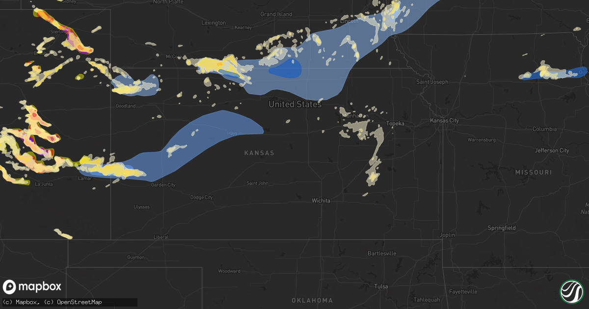
Hail Map in Kansas on August 9, 2025
Get this storm
August 9 map
$229
one time, instant access
Download today. No call, no setup
Keep the $229
Bought the map and want the full workflow? Apply the entire $229 to a subscription within 7 days. None of it is wasted.
Every map, not just this one
This buys you this map. Subscription and you get every map we run, in the markets you choose from a few cities to whole states to nationwide. Plus real-time alerts the moment a storm fires.
Contact data
Name, contact info, occupancy, even credit band for addresses in the footprint. You go from where it hit to who to call.
Become the source they trust
Unlimited branding weather history reports on demand. You already have the documented answer ready for the property owner, and you are the one who showed up with it.
Property data and RoofTrace estimates
Pull up any address you have got, its value and the exact code rules for that jurisdiction, straight from One Click Code. Then RoofTrace estimates the squares, pitch, and roof value, priced the way you price.
Storm reports in Kansas
Kansas
| Date | Description |
|---|---|
| 08/09/20254:50 AM CDT | Wind gust was reported by kansas mesonet. |
| 08/09/20254:34 AM CDT | Davis weather station. |
| 08/09/20254:28 AM CDT | A local report indicates 72 MPH wind near 6 NE Gorham |
| 08/09/20254:15 AM CDT | Awos station khys hays regional airport awos site. |
| 08/09/20254:04 AM CDT | Pws station kkspalco33. |
| 08/09/20254:04 AM CDT | Mesonet station up856 0.8 e yocemento |
| 08/09/20253:59 AM CDT | Pws - kksellis46. |
| 08/09/20252:55 AM CDT | Pws hineman farms - kksdight22. |
| 08/09/20251:42 AM CDT | Public weather station. |
| 08/09/20251:35 AM CDT | Awos station k3k3 syracuse. |
| 08/09/20251:35 AM CDT | A local report indicates 74 MPH wind near Salina Airport |
| 08/09/20251:32 AM CDT | A local report indicates 64 MPH wind near 2 S Washington |
| 08/09/20251:20 AM CDT | 3-4 inch tree branches down. |
| 08/09/202512:58 AM CDT | A local report indicates 61 MPH wind near 2 SSE Concordia |
| 08/09/202512:53 AM CDT | Public weather station. |
| 08/09/202512:49 AM CDT | A local report indicates 67 MPH wind near 2 W Belleville |
| 08/09/202512:39 AM CDT | Outflow from the thunderstorm. |
| 08/09/202512:33 AM CDT | A local report indicates 60 MPH wind near Randall |
| 08/09/202512:32 AM CDT | A local report indicates 59 MPH wind near Jewell |
| 08/09/202512:22 AM CDT | A local report indicates 68 MPH wind near 3 WNW Jewell |
| 08/09/202512:20 AM CDT | Kansas mesonet. |
| 08/09/202512:20 AM CDT | Davis weather station. |
| 08/09/202512:20 AM CDT | A local report indicates 67 MPH wind near 6 WSW Beloit |
| 08/09/202512:15 AM CDT | A local report indicates 70 MPH wind near Russell Airport |
| 08/08/202511:55 PM CDT | A local report indicates 60 MPH wind near Smith Center Airport |
| 08/08/202511:55 PM CDT | A local report indicates 58 MPH wind near 8 N Bellaire |
| 08/08/202511:08 PM CDT | A local report indicates 71 MPH wind near Phillipsburg Airport |
| 08/08/202510:44 PM CDT | A local report indicates 86 MPH wind near 4 ESE Long Island |
| 08/08/202510:38 PM CDT | A local report indicates 58 MPH wind near 4 SSE Long Island |
| 08/08/202510:24 PM CDT | A local report indicates 59 MPH wind near 6 NNE Almena |
| 08/08/20258:30 PM CDT | Nws employee reports 65 mph gust. |
| 08/08/20258:08 PM CDT | A local report indicates 71 MPH wind near 4 WNW Bird City |
| 08/08/20258:04 PM CDT | Awos station ksyf st. Francis city. |
| 08/08/20258:04 PM CDT | Awos station ksyf st. Francis. |
All States Impacted by Hail Map on August 9, 2025
Cities Impacted by Hail Map on August 9, 2025
- Charter Oak, IA
- Manilla, IA
- Defiance, IA
- Mapleton, IA
- Deloit, IA
- Arion, IA
- Onawa, IA
- Schleswig, IA
- Denison, IA
- Dunlap, IA
- Soldier, IA
- Irwin, IA
- Dow City, IA
- Ute, IA
- Kirkman, IA
- Vail, IA
- Earling, IA
- Castana, IA
- Rodney, IA
- Ricketts, IA
- Smithland, IA
- Battle Creek, IA
- Kiron, IA
- Manning, IA
- Audubon, IA
- Altamont, MO
- Independence, WI
- Bancroft, IA
- Arcadia, WI
- Zumbrota, MN
- Pine Island, MN
- Dorchester, WI
- Medford, WI
- Withee, WI
- Lake View, IA
- Sac City, IA
- Swea City, IA
- Ledyard, IA
- Lakota, IA
- Greenwood, WI
- Elmore, MN
- Buffalo Center, IA
- Blue Earth, MN
- Whitehall, WI
- Osseo, WI
- Curtiss, WI
- Mazeppa, MN
- Wall Lake, IA
- Aspinwall, IA
- Templeton, IA
- Carroll, IA
- Halbur, IA
- Westside, IA
- Dedham, IA
- Arcadia, IA
- Gray, IA
- Zumbro Falls, MN
- Lake City, MN
- Lytton, IA
- Stetsonville, WI
- Millville, MN
- Bricelyn, MN
- Frost, MN
- Auburn, IA
- Owen, WI
- Fountain City, WI
- Winston, MO
- Glidden, IA
- Breda, IA
- Lidderdale, IA
- Oto, IA
- Danbury, IA
- Ida Grove, IA
- Holstein, IA
- Anthon, IA
- Correctionville, IA
- Cushing, IA
- Churdan, IA
- Lake City, IA
- Havelock, IA
- Dodge Center, MN
- Hayfield, MN
- Blooming Prairie, MN
- Taylor, WI
- Kidder, MO
- Laurens, IA
- Wells, MN
- Wabasha, MN
- Cochrane, WI
- Kellogg, MN
- Kiester, MN
- Rockwell City, IA
- Jolley, IA
- Scranton, IA
- Ralston, IA
- Coon Rapids, IA
- Lohrville, IA
- Lanesboro, IA
- Mallard, IA
- Athens, WI
- Edgar, WI
- Alden, MN
- Hixton, WI
- Black River Falls, WI
- Pomeroy, IA
- Kasson, MN
- Alma, WI
- Manson, IA
- Somers, IA
- Farnhamville, IA
- Blair, WI
- Conover, WI
- Whittemore, IA
- Algona, IA
- West Bend, IA
- Lyle, MN
- Rose Creek, MN
- Oronoco, MN
- Rolfe, IA
- Knierim, IA
- Galesville, WI
- Mantorville, MN
- Curlew, IA
- Moorland, IA
- Callender, IA
- Gowrie, IA
- Barnum, IA
- Sargeant, MN
- Dexter, MN
- Brownsdale, MN
- Austin, MN
- Waltham, MN
- Eagle River, WI
- Three Lakes, WI
- Britt, IA
- Minnesota City, MN
- Mosinee, WI
- Lone Rock, IA
- Emmetsburg, IA
- Hatley, WI
- Burt, IA
- Ettrick, WI
- Woden, IA
- Crystal Lake, IA
- Forest City, IA
- Corwith, IA
- Schofield, WI
- Byron, MN
- Rochester, MN
- Clear Lake, IA
- Ventura, IA
- Stewartville, MN
- Spring Valley, MN
- Garner, IA
- Wesley, IA
- Joice, IA
- Lake Mills, IA
- Grand Meadow, MN
- Racine, MN
- Leland, IA
- Hanlontown, IA
- Fertile, IA
- Elkton, MN
- Adams, MN
- Chatfield, MN
- Mason City, IA
- Eyota, MN
- Wykoff, MN
- Dover, MN
- Manly, IA
- Wisconsin Rapids, WI
- Kensett, IA
- Saint Ansgar, IA
- Saint Charles, MN
- Plainview, MN
- Elgin, MN
- Cumberland, IA
- Stevens Point, WI
- Rudolph, WI
- Massena, IA
- Junction City, WI
- Milladore, WI
- Altura, MN
- Trempealeau, WI
- Riceville, IA
- Winona, MN
- Dakota, MN
- Houston, MN
- Rollingstone, MN
- De Soto, WI
- Viroqua, WI
- Coon Valley, WI
- Stoddard, WI
- Chaseburg, WI
- Westby, WI
- Cashton, WI
- La Farge, WI
- Ontario, WI
- Norwalk, WI
- Hillsboro, WI
- Kendall, WI
- Sterlington, LA
- Green Bay, WI
- West Monroe, LA
- Poynette, WI
- Denmark, WI
- De Pere, WI
- New Franken, WI
- Ogdensburg, WI
- Scandinavia, WI
- Waupaca, WI
- Portage, WI
- Luxemburg, WI
- Iola, WI
- Manawa, WI
- New London, WI
- Bear Creek, WI
- Weyauwega, WI
- Clintonville, WI
- Broadwater, NE
- Downing, MO
- Casco, WI
- Omro, WI
- Shiocton, WI
- Columbus, WI
- Appleton, WI
- Black Creek, WI
- Sun Prairie, WI
- Bushnell, NE
- Kaukauna, WI
- Algoma, WI
- Sturgeon Bay, WI
- Forestville, WI
- Bonduel, WI
- Merriman, NE
- Kimball, NE
- Seymour, WI
- Jonesboro, LA
- New Raymer, CO
- Glenbeulah, WI
- Green Castle, MO
- Novinger, MO
- Kewaunee, WI
- Kiel, WI
- Padroni, CO
- Stoneham, CO
- Elkhart Lake, WI
- Agate, CO
- Valders, WI
- New Holstein, WI
- Maribel, WI
- Hartford, WI
- Menominee, MI
- Juneau, WI
- West Bend, WI
- Marshall, WI
- Dix, NE
- Potter, NE
- Wiggins, CO
- Fort Morgan, CO
- Merino, CO
- Whitman, NE
- Deer Trail, CO
- Sidney, NE
- Kewaskum, WI
- Sterling, CO
- Valentine, NE
- Woodrow, CO
- Iliff, CO
- Fleming, CO
- Limon, CO
- Donnellson, IA
- Farmington, IA
- Cedarburg, WI
- Slinger, WI
- Elizabeth, CO
- Kiowa, CO
- Grafton, WI
- Marengo, IL
- Akron, CO
- Lindon, CO
- Matheson, CO
- Sussex, WI
- Woodstock, IL
- Lannon, WI
- Menomonee Falls, WI
- Pewaukee, WI
- Waukesha, WI
- Brookfield, MO
- Bucklin, MO
- Kim, CO
- Thedford, NE
- Otis, CO
- Haxtun, CO
- Cody, NE
- Brookfield, WI
- Milwaukee, WI
- Mequon, WI
- Gibbs, MO
- Brashear, MO
- La Plata, MO
- Elfrida, AZ
- Sugar Land, TX
- Yuma, CO
- Brookshire, TX
- Ethel, MO
- New Cambria, MO
- Katy, TX
- Wood Lake, NE
- Pritchett, CO
- Hugo, CO
- Johnstown, NE
- Elsmere, NE
- Callao, MO
- Elmer, MO
- Novelty, MO
- Hurdland, MO
- Macon, MO
- Atlanta, MO
- Patagonia, AZ
- Nogales, AZ
- Snyder, CO
- Bellville, TX
- Eagle Lake, TX
- East Bernard, TX
- Oak Creek, WI
- Sublette, IL
- La Moille, IL
- Mendota, IL
- Chappell Hill, TX
- Leonard, MO
- Anabel, MO
- Clarence, MO
- Brush, CO
- Ramah, CO
- Eckley, CO
- Halsey, NE
- McNeal, AZ
- Shelbyville, MO
- Columbus, TX
- Bethel, MO
- Newark, MO
- New Berlin, WI
- Purdum, NE
- Compton, IL
- Wray, CO
- Steward, IL
- Paw Paw, IL
- New Ulm, TX
- Atwood, CO
- Bisbee, AZ
- Dekalb, IL
- La Belle, MO
- Hubertus, WI
- Richfield, WI
- Jackson, WI
- Holyoke, CO
- Paoli, CO
- Emden, MO
- Ewing, MO
- Hereford, AZ
- Philadelphia, MO
- Genoa, IL
- Karval, CO
- Big Bend, WI
- Muskego, WI
- Saint Francis, KS
- Haigler, NE
- Vernon, CO
- Hayes Center, NE
- Simla, CO
- Palmyra, MO
- Maywood, MO
- Durham, MO
- Taylor, MO
- Elkhorn, WI
- Deerfield, WI
- Idalia, CO
- Palisade, NE
- Hales Corners, WI
- Mukwonago, WI
- Mullen, NE
- Franklin, WI
- Delafield, WI
- Oconomowoc, WI
- Wales, WI
- Dousman, WI
- East Troy, WI
- Calhan, CO
- Curtis, NE
- Eagle, WI
- Goodland, KS
- Trenton, NE
- Peyton, CO
- Yoder, CO
- Hillrose, CO
- Pearce, AZ
- North Prairie, WI
- Bird City, KS
- Edson, KS
- Colorado Springs, CO
- Rush, CO
- McCook, NE
- Culbertson, NE
- McDonald, KS
- Colby, KS
- Indianola, NE
- Danbury, NE
- Orangeville, IL
- Juda, WI
- Lebanon, NE
- Elm Grove, WI
- Butler, WI
- Levant, KS
- Atwood, KS
- Rock City, IL
- Brodhead, WI
- Brady, NE
- Wilsonville, NE
- Ordway, CO
- Fountain, CO
- Beaver City, NE
- Arapahoe, NE
- Hendley, NE
- Ludell, KS
- Norcatur, KS
- Boone, CO
- Reeseville, WI
- Stamford, NE
- Orleans, NE
- Norton, KS
- Hyannis, NE
- Lake Geneva, WI
- Sugar City, CO
- Almena, KS
- Long Island, KS
- Oxford, NE
- Alma, NE
- Burlington, WI
- Kansasville, WI
- Edison, NE
- Edgerton, WI
- Olney Springs, CO
- Prairie View, KS
- Phillipsburg, KS
- Johnson Creek, WI
- Fort Atkinson, WI
- Stoughton, WI
- Madison, WI
- Palmyra, WI
- Whitewater, WI
- Waterford, WI
- Helenville, WI
- Cottage Grove, WI
- Mcfarland, WI
- Lenora, KS
- Selden, KS
- Watertown, WI
- Jefferson, WI
- Arlington, CO
- Agra, KS
- Republican City, NE
- Hill City, KS
- Morland, KS
- Fairbury, NE
- Logan, KS
- Eads, CO
- Haswell, CO
- Roseland, NE
- Inland, NE
- Hastings, NE
- Glenvil, NE
- Ayr, NE
- Kensington, KS
- Kirwin, KS
- Naponee, NE
- Penrose, CO
- Holstein, NE
- Campbell, NE
- Cedar, KS
- Gaylord, KS
- Riverton, NE
- Franklin, NE
- Bloomington, NE
- Smith Center, KS
- Athol, KS
- Alton, KS
- Pueblo, CO
- Bogue, KS
- Waunakee, WI
- Deforest, WI
- Bladen, NE
- Nelson, NE
- Superior, NE
- Hardy, NE
- Harvard, NE
- Saronville, NE
- Clay Center, NE
- Osborne, KS
- Portis, KS
- Red Cloud, NE
- Inavale, NE
- Lebanon, KS
- Windsor, WI
- Liberty, NE
- Arthur, NE
- Tryon, NE
- Virginia, NE
- Minden, NE
- Blue Springs, NE
- Sheridan Lake, CO
- Oak, NE
- Lawrence, NE
- Blue Hill, NE
- Abbotsford, WI
- Plainville, KS
- Dodge, WI
- Strum, WI
- Davenport, NE
- Ohiowa, NE
- Tobias, NE
- Elma, IA
- Beatrice, NE
- Carleton, NE
- Thompson, IA
- Lansing, IA
- Guide Rock, NE
- Deweese, NE
- Filley, NE
- Pepin, WI
- La Junta, CO
- Downs, KS
- Mankato, KS
- Burr Oak, KS
- Esbon, KS
- Avondale, CO
- Stockton, KS
- Sullivan, WI
- Racine, WI
- Lamar, CO
- Edgar, NE
- Wiley, CO
- Sutherland, NE
- Alexandria, NE
- Daykin, NE
- Plymouth, NE
- Jansen, NE
- Sutton, NE
- Randall, KS
- Jewell, KS
- Formoso, KS
- Webber, KS
- Fowler, CO
- Fairfield, NE
- Pickrell, NE
- Milligan, NE
- Ong, NE
- Elmwood, NE
- Tecumseh, NE
- De Witt, NE
- Holly, CO
- Beaver Crossing, NE
- Adams, NE
- Grafton, NE
- Cook, NE
- Seward, NE
- Milford, NE
- Tribune, KS
- Scandia, KS
- Norway, KS
- Jamestown, KS
- Beloit, KS
- Courtland, KS
- Belleville, KS
- Concordia, KS
- Republic, KS
- Chester, NE
- Hebron, NE
- Byron, NE
- Cuba, KS
- Munden, KS
- Deshler, NE
- Hubbell, NE
- Ruskin, NE
- Agenda, KS
- Gilead, NE
- Pleasant Dale, NE
- Monroe, IA
- Runnells, IA
- Prairie City, IA
- Exeter, NE
- Geneva, NE
- Fairmont, NE
- North Platte, NE
- Eagle, NE
- Alvo, NE
- Woodston, KS
- Murdock, NE
- Clatonia, NE
- Pacific Junction, IA
- Talmage, NE
- Brock, NE
- Lincoln, NE
- Cortland, NE
- Syracuse, KS
- Blue River, WI
- Boscobel, WI
- Muscoda, WI
- Nebraska City, NE
- Clyde, KS
- Otoe, NE
- Martell, NE
- Hallam, NE
- Firth, NE
- Dunbar, NE
- Shickley, NE
- Greenwood, NE
- Waverly, NE
- Malcolm, NE
- Silver City, IA
- Glenwood, IA
- Ixonia, WI
- Weeping Water, NE
- Syracuse, NE
- Avoca, NE
- Neosho, WI
- Haddam, KS
- Morganville, KS
- Aurora, KS
- Clifton, KS
- Mahaska, KS
- Narka, KS
- Strang, NE
- Belvidere, NE
- Bruning, NE
- Manzanola, CO
- Hanover, IL
- Mineola, IA
- Plattsmouth, NE
- Union, NE
- Percival, IA
- Nehawka, NE
- Lynnville, IA
- Newton, IA
- Nashotah, WI
- Hartland, WI
- Okauchee, WI
- Reasnor, IA
- Sully, IA
- Hamburg, IA
- Sidney, IA
- Reynolds, NE
- Washington, KS
- Linn, KS
- Greenleaf, KS
- Clay Center, KS
- Morrowville, KS
- Green, KS
- Palmer, KS
- Barnes, KS
- Randolph, KS
- Diller, NE
- Wilber, NE
- Dorchester, NE
- Hollenberg, KS
- Friend, NE
- Endicott, NE
- Steele City, NE
- Hanover, KS
- Swanton, NE
- Western, NE
- Crete, NE
- Bellevue, NE
- Wapello, IA
- Columbus Junction, IA
- Springfield, NE
- Galena, IL
- Thurman, IA
- Grinnell, IA
- Tabor, IA
- Murray, NE
- Monument, KS
- Oakley, KS
- Burnett, WI
- Dresden, KS
- Kendall, KS
- Papillion, NE
- Longford, KS
- New Boston, IL
- Lakin, KS
- Leoti, KS
- Deerfield, KS
- Marienthal, KS
- Scott City, KS
- Abilene, KS
- Granada, CO
- Malvern, IA
- Montezuma, IA
- Solomon, KS
- Treynor, IA
- Louisville, NE
- Gretna, NE
- La Vista, NE
- Omaha, NE
- Underwood, IA
- Council Bluffs, IA
- McClelland, IA
- Olsburg, KS
- Manhattan, KS
- Leonardville, KS
- Riley, KS
- Oakland, IA
- Lodi, WI
- Waterloo, WI
- Junction City, KS
- Minden, IA
- Unadilla, NE
- Odell, NE
- Waterville, KS
- Marysville, KS
- Bremen, KS
- Wymore, NE
- Oketo, KS
- Johnson, NE
- Crab Orchard, NE
- Sterling, NE
- Burchard, NE
- Elk Creek, NE
- Douglas, NE
- Lewiston, NE
- Steinauer, NE
- Walton, NE
- Panama, NE
- Denton, NE
- Bennet, NE
- Roca, NE
- Burr, NE
- Sprague, NE
- Palmyra, NE
- Hickman, NE
- Holcomb, KS
- Gove, KS
- Dighton, KS
- Garden City, KS
- Healy, KS
- Lone Rock, WI
- Gotham, WI
- Lincoln, KS
- White City, KS
- Westmoreland, KS
- Wamego, KS
- Belvue, KS
- Fort Riley, KS
- Ogden, KS
- Hustisford, WI
- Humboldt, NE
- Table Rock, NE
- Saint George, KS
- Hancock, IA
- Avoca, IA
- Atlantic, IA
- Peru, NE
- Lorton, NE
- Julian, NE
- Riverton, IA
- Rock Port, MO
- Randolph, IA
- Elliott, IA
- Griswold, IA
- Hastings, IA
- Alta Vista, KS
- Dwight, KS
- Carson, IA
- Walnut, IA
- Marne, IA
- Emmett, KS
- Saint Marys, KS
- Alma, KS
- Lewis, IA
- Onaga, KS
- Dawson, NE
- Spring Green, WI
- Delia, KS
- Council Grove, KS
- Colo, IA
- Zearing, IA
- Saint Anthony, IA
- Quinter, KS
- Imogene, IA
- Emerson, IA
- Hubbard, IA
- New Providence, IA
- Swan, IA
- Farragut, IA
- Rio, WI
- Maple Hill, KS
- New Sharon, IA
- Joy, IL
- Iron Ridge, WI
- Collyer, KS
- Illinois City, IL
- Gilbert, IA
- Essex, IA
- Clarinda, IA
- Stanton, IA
- Red Oak, IA
- Shenandoah, IA
- Villisca, IA
- Henderson, IA
- Macedonia, IA
- Rose Hill, IA
- What Cheer, IA
- Roland, IA
- Harveyville, KS
- Eskridge, KS
- Exira, IA
- Elk Horn, IA
- Ames, IA
- Topeka, KS
- Brayton, IA
- Story City, IA
- Redfield, IA
- Guthrie Center, IA
- Nevada, IA
- Casey, IA
- Mineral Point, WI
- Barnes City, IA
- Adair, IA
- Paxico, KS
- McCallsburg, IA
- Reynolds, IL
- Aledo, IL
- Beeler, KS
- Arnold, KS
- Gorham, KS
- Ransom, KS
- Brownell, KS
- Hays, KS
- McCracken, KS
- Victoria, KS
- Ness City, KS
- Wakeeney, KS
- Ellis, KS
- Utica, KS
- Walker, KS
- Russell, KS
- Ogallah, KS
- Catharine, KS
- Palco, KS
- Paradise, KS
- Natoma, KS
- Park, KS
- Grinnell, KS
- Linden, IA
- Adel, IA
- Emporia, KS
- Minburn, IA
- Yale, IA
- Admire, KS
- Olpe, KS
- Dallas Center, IA
- Elgin, IA
- Allen, KS
- Reading, KS
- Bagley, IA
- Bayard, IA
- Jefferson, IA
- Madison, KS
- Farmersburg, IA
- Luana, IA
- Saint Olaf, IA
- Monona, IA
- Postville, IA
- Clemons, IA
- Burlingame, KS
- Muscatine, IA
- Letts, IA
- Boone, IA
- Stockton, IA
- Durant, IA
- Holland, IA
- Grundy Center, IA
- Dike, IA
- Reinbeck, IA
- Taylor Ridge, IL
- Colfax, IA
- Wiota, IA
- Waukee, IA
- De Soto, IA
- Fontanelle, IA
- Greenfield, IA
- Menlo, IA
- Grant, IA
- Stuart, IA
- Bridgewater, IA
- Dexter, IA
- Prescott, IA
- Corning, IA
- Orient, IA
- Earlham, IA
- Nodaway, IA
- Anita, IA
- Hamlin, IA
- Panora, IA
- Bunker Hill, KS
- Waldo, KS
- Elkhart, IA
- Maxwell, IA
- Wilton, IA
- Cambridge, IA
- Madrid, IA
- Paton, IA
- Ogden, IA
- Dana, IA
- Blue Grass, IA
- Perry, IA
- Jamaica, IA
- Dawson, IA
- Hamilton, KS
- Hartford, KS
- Neosho Rapids, KS
- Woodward, IA
- Walcott, IA
- Montpelier, IA
- Eureka, KS
- Minneapolis, KS
- Kellogg, IA
- Traer, IA
- Gilman, IA
- Wakarusa, KS
- Parnell, IA
- Williamsburg, IA
- Elberon, IA
- Chelsea, IA
- Bevier, MO
- La Grange, MO
- Monroe City, MO
- Quincy, IL
- Schaller, IA
- Early, IA
- Galva, IA
- Arthur, IA
- Odebolt, IA


