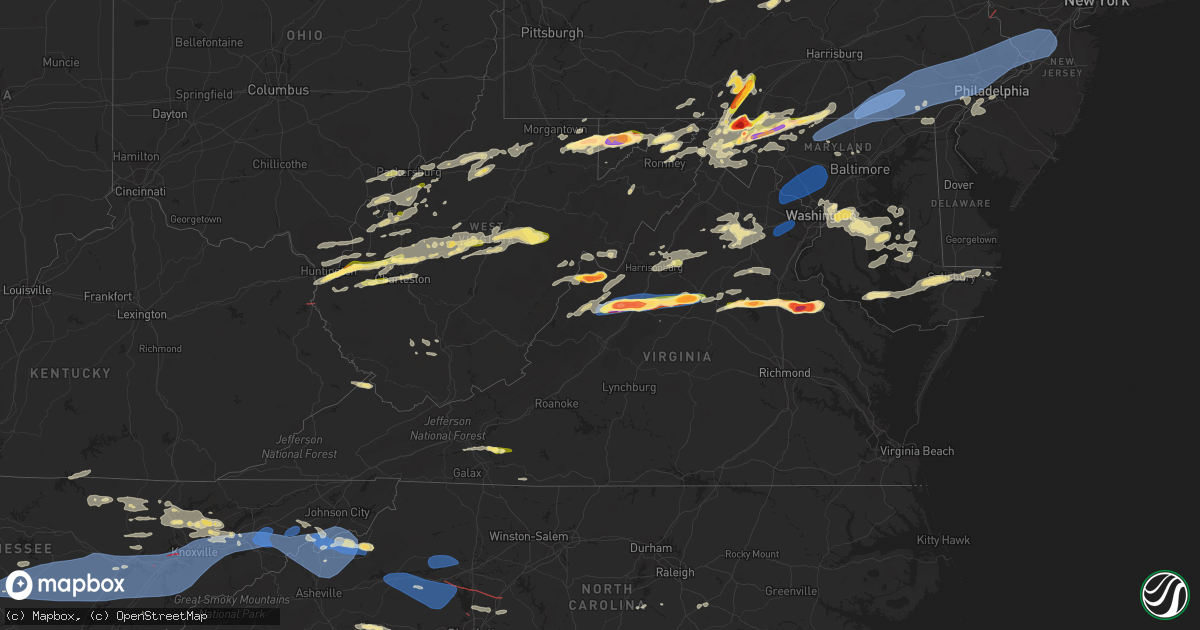
Hail Map in Virginia on August 7, 2023
Get this storm
August 7 map
$229
one time, instant access
Download today. No call, no setup
Keep the $229
Bought the map and want the full workflow? Apply the entire $229 to a subscription within 7 days. None of it is wasted.
Every map, not just this one
This buys you this map. Subscription and you get every map we run, in the markets you choose from a few cities to whole states to nationwide. Plus real-time alerts the moment a storm fires.
Contact data
Name, contact info, occupancy, even credit band for addresses in the footprint. You go from where it hit to who to call.
Become the source they trust
Unlimited branding weather history reports on demand. You already have the documented answer ready for the property owner, and you are the one who showed up with it.
Property data and RoofTrace estimates
Pull up any address you have got, its value and the exact code rules for that jurisdiction, straight from One Click Code. Then RoofTrace estimates the squares, pitch, and roof value, priced the way you price.
Storm reports in Virginia
Virginia
| Date | Description |
|---|---|
| 08/07/20236:20 PM CDT | A local report indicates 2.75 inch wind near 3 NW Supply |
| 08/07/20236:05 PM CDT | Corrects previous hail report from 1 ssw fort a.p. Hill. Time estimated from radar. Hail stone was measured approximately 15 minutes after the hail core passed over thi |
| 08/07/20236:05 PM CDT | Time estimated from radar. Hail stone was measured approximately 15 minutes after the hail core passed over this location. |
| 08/07/20235:40 PM CDT | Corrects previous hail report from 1 nnw fort a.p. Hill. Golf ball sized hail reported near fort ap hill. |
| 08/07/20235:37 PM CDT | Numerous trees down along highway 311 between white sulphur springs wv and crows va. |
| 08/07/20235:10 PM CDT | Golf ball sized hail report |
| 08/07/20235:10 PM CDT | Golf ball sized hail reported near fort ap hill. |
| 08/07/20235:07 PM CDT | Trained spotter reports golf ball sized hail near lake anna state park. Time estimated from radar. |
| 08/07/20234:51 PM CDT | Multiple trees down in coal landing. |
| 08/07/20234:48 PM CDT | Trees down on monrovia road near shady grove lane. Wires down as well. |
| 08/07/20234:38 PM CDT | Tree down at intersection of forum dr and gov't center pkwy |
| 08/07/20234:36 PM CDT | Large tree down onto chase commons court. |
| 08/07/20234:35 PM CDT | Corrects previous tstm wnd dmg report from 4 nne waldrop. One tree and several large tree limbs downed along us-15 between waldrop and gordonsville. |
| 08/07/20234:33 PM CDT | Tree down in nokesville. |
| 08/07/20234:33 PM CDT | Multiple roads closed due to downed trees between somerville and bristersburg. |
| 08/07/20234:32 PM CDT | Tree down near the intersection of kettle club road and north james madison highway |
| 08/07/20234:32 PM CDT | Tree down on judicial drive near yorktown court. |
| 08/07/20234:30 PM CDT | Tree down in 11500 block of valley road. |
| 08/07/20234:29 PM CDT | Tree down onto parked car on south penderbrook drive at the intersection with iverness road. |
| 08/07/20234:28 PM CDT | Considerable tree damage on quiet brook road. Numerous trees uprooted. At least a dozen pine trees snapped in half. |
| 08/07/20234:24 PM CDT | 51kt measured at manassas arpt |
| 08/07/20234:20 PM CDT | A large tree was blown down by thunderstorm winds near the intersection of highway 58 and soapstone road. |
| 08/07/20234:19 PM CDT | A tree was blown down onto a home along old well road by thunderstorm winds... Trapping a resident inside the home. |
| 08/07/20234:19 PM CDT | Multiple large tree branches down on the 7500 block of alleghany road. |
| 08/07/20234:18 PM CDT | Several trees down along lesters fork road. Time estimated from radar. |
| 08/07/20234:17 PM CDT | A large tree was blown down across a power line along marigold road by thunderstorm winds. Power is out in the local area. |
| 08/07/20234:17 PM CDT | Tree down along hazel river road |
| 08/07/20234:16 PM CDT | Multiple trees were blown down along penn store road by thunderstorm winds. |
| 08/07/20234:14 PM CDT | Wind gust of 50 knots measured at nova loudon cmapus sterling. |
| 08/07/20234:12 PM CDT | Thunderstorm winds blew a tree down along route 58... Approximately four miles west of spencer. Report in twitter. |
| 08/07/20234:10 PM CDT | Golf ball sized hail observed near earlysville. |
| 08/07/20234:09 PM CDT | A couple trees down on furnace mountain road. |
| 08/07/20234:08 PM CDT | A local report indicates 1.75 inch wind near 3 N Earlysville |
| 08/07/20234:05 PM CDT | One tree and several large tree limbs downed along us-15 between waldrop and gordonsville. |
| 08/07/20234:04 PM CDT | At least 6 trees down within a block of an nws employees home in ashburn. |
| 08/07/20234:04 PM CDT | Multiple trees... Power lines... And branches down in earlysville. Several roads closed. |
| 08/07/20234:02 PM CDT | Tops of trees blown off and 1 tree uprooted. |
| 08/07/20234:02 PM CDT | A local report indicates 2.50 inch wind near Earlysville |
| 08/07/20233:59 PM CDT | Over a dozen trees down between warrenton and old tavern. Several wires and poles down as well. |
| 08/07/20233:54 PM CDT | Multiple trees were blown down across the southern end of the community of stuart by thunderstorm winds. |
| 08/07/20233:52 PM CDT | Multiple trees down on enon school road. |
| 08/07/20233:49 PM CDT | Tree down along quail ridge drive |
| 08/07/20233:49 PM CDT | Tree down near the intersection of 7 ponds road and view town road |
| 08/07/20233:48 PM CDT | A couple trees down on waterford road. |
| 08/07/20233:48 PM CDT | Trees down on rixleyville road. Wires also down in a couple locations. |
| 08/07/20233:47 PM CDT | Multiple trees down in far northeastern fauquier county around halfway road... The plains road... Rock hill mill road... And adjoining roads. |
| 08/07/20233:46 PM CDT | Tree down near the intersection of garth road and yule farm |
| 08/07/20233:44 PM CDT | Tree down on powerlines near the intersection of dodson road and starwood drive |
| 08/07/20233:44 PM CDT | Tree down near the intersection of view town road and barn view lane |
| 08/07/20233:41 PM CDT | Tree down near the intersection of richmond road and campground lane |
| 08/07/20233:39 PM CDT | Multiple trees down in the upperville. Several wires down as well. |
| 08/07/20233:38 PM CDT | Multiple trees were blown down in the community of claudville by thunderstorm winds. |
| 08/07/20233:37 PM CDT | Tree down near the intersection of sperryville pike and yancy road |
| 08/07/20233:29 PM CDT | A local report indicates 2.00 inch wind near 2 NW Waynesboro |
| 08/07/20233:29 PM CDT | Media relayed report of quarter sized hail on grindstone mountain road in comertown... Va. Time estimated from radar. |
| 08/07/20233:29 PM CDT | Several trees down in loudoun heights. |
| 08/07/20233:26 PM CDT | Multiple calls for downed trees and wires in berryville. |
| 08/07/20233:26 PM CDT | Over a dozen trees down on leeds manor road and nearby roads just south of i-66. |
| 08/07/20233:25 PM CDT | A local report indicates 1.50 inch wind near 4 SW Hermitage |
| 08/07/20233:23 PM CDT | Numerous trees down along weakley hollow road |
| 08/07/20233:22 PM CDT | A local report indicates 2.50 inch wind near 2 S Staunton |
| 08/07/20233:19 PM CDT | Multiple trees down along fodderstack road |
| 08/07/20233:16 PM CDT | Three trees down near the 4000 block of remount road |
| 08/07/20233:15 PM CDT | Numerous trees down in shenandoah. |
| 08/07/20233:15 PM CDT | A local report indicates 2.00 inch wind near 2 S Staunton |
| 08/07/20233:15 PM CDT | Golf ball sized hail measured near staunton. |
| 08/07/20233:14 PM CDT | Tree down on the 400 block of blainesville road |
| 08/07/20233:09 PM CDT | A local report indicates 3.00 inch wind near Trimbles Mill |
| 08/07/20233:08 PM CDT | Tree down near the intersection of crooked run road and comertown road |
| 08/07/20233:08 PM CDT | Tree down on the 1100 block of ridge view lane |
| 08/07/20233:05 PM CDT | Tree down on the 400 block of 3rd street |
| 08/07/20233:04 PM CDT | Numerous trees down near battle creek road and north view drive. |
| 08/07/20233:03 PM CDT | Multiple reports of downed trees in gainesboro. |
| 08/07/20233:03 PM CDT | Tree down along 10th street |
| 08/07/20233:03 PM CDT | Tree down on the 400 block of grove hill river road |
| 08/07/20233:02 PM CDT | A couple calls for downed trees and wires in cross junction. |
| 08/07/20233:01 PM CDT | Trees down on wardensville grade road... Singhass road... Dicks hollow road... And us-50. |
| 08/07/20233:00 PM CDT | Trees down on indian hollow road. Road closed. |
| 08/07/20232:53 PM CDT | Tree down near the 100 block of dogwood drive |
| 08/07/20232:51 PM CDT | Tree down on powerlines near the 200 block of aspen trail |
| 08/07/20232:48 PM CDT | Multiple trees down in craigsville per whsv. Photos provided. |
| 08/07/20232:48 PM CDT | Tree down near the intersection of south page valley road and egypt bend road |
| 08/07/20232:45 PM CDT | Multiple trees down in new market per whsv. Photos provided. |
| 08/07/20232:39 PM CDT | Tree down on the 400 block of south main street |
| 08/07/20232:37 PM CDT | Multiple trees down in broadway per whsv. Photos provided. |
| 08/07/20232:37 PM CDT | Metal roof blown off a barn in broadway. |
| 08/07/20232:35 PM CDT | Tree down on powerlines near the 300 block of cross junction road |
| 08/07/20232:33 PM CDT | Tree down on the 400 block of west springbrook road |
| 08/07/20232:25 PM CDT | A local report indicates 1.00 inch wind near 1 N Willis |
| 08/07/20232:23 PM CDT | Quarter to half-dollar sized hail was observed at the intersection of highway 221 and indian valley road. |
| 08/07/20232:16 PM CDT | Tree down on powerlines near the intersection of bare ridge road and hopkins gap road |
| 08/07/20232:15 PM CDT | Multiple reports of trees down across county. Reported tree down across roadway off of whites mill road. |
| 08/07/20231:55 PM CDT | Wdbj photo relayed of tennis ball sized hail. |
| 08/07/20231:47 PM CDT | Whsv photo of two inch hail. |
| 08/07/20231:39 PM CDT | Multiple trees down on mill gap road in mill gap. Road closed for several hours. |
| 08/07/20231:37 PM CDT | Considerable tree damage on blue grass valley road and laurel fork road. |
| 08/07/202312:50 PM CDT | Several trees downed in the chilhowie area. |
| 08/06/20238:01 PM CDT | Multiple reports of downed trees near gore toward the west virginia state line. |
All States Impacted by Hail Map on August 7, 2023
Cities Impacted by Hail Map on August 7, 2023
- Whiteville, TN
- Somerville, TN
- Bolivar, TN
- Hickory Valley, TN
- Saulsbury, TN
- Middleton, TN
- Hornsby, TN
- Bethel Springs, TN
- Selmer, TN
- Pocahontas, TN
- Ramer, TN
- Guys, TN
- Lutts, TN
- Counce, TN
- Adamsville, TN
- Savannah, TN
- Shiloh, TN
- Michie, TN
- Stantonville, TN
- Collinwood, TN
- Olivehill, TN
- Crump, TN
- Cypress Inn, TN
- Waynesboro, TN
- Coolville, OH
- Little Hocking, OH
- Shelbyville, KY
- Midway, KY
- Frankfort, KY
- Bagdad, KY
- Stamping Ground, KY
- Georgetown, KY
- Shelbyville, TN
- Unionville, TN
- Bell Buckle, TN
- Beechgrove, TN
- Wartrace, TN
- Manchester, TN
- Morrison, TN
- Mcminnville, TN
- Rock Island, TN
- Pikeville, TN
- Spencer, TN
- Dunlap, TN
- Reedsville, WV
- Arthurdale, WV
- Kingwood, WV
- Albright, WV
- Independence, WV
- Bruceton Mills, WV
- Terra Alta, WV
- Duck, WV
- Frametown, WV
- Gassaway, WV
- Mineral Wells, WV
- Walker, WV
- Elizabeth, WV
- Big Pool, MD
- Clear Spring, MD
- Huntington, WV
- Barboursville, WV
- Rock Cave, WV
- French Creek, WV
- Pickens, WV
- Helvetia, WV
- Hazel Green, AL
- New Market, AL
- Estillfork, AL
- Scottsboro, AL
- Stevenson, AL
- Sherwood, TN
- South Pittsburg, TN
- Bridgeport, AL
- Bryant, AL
- Flat Rock, AL
- Guild, TN
- Chattanooga, TN
- Wildwood, GA
- Jasper, TN
- Trenton, GA
- Whitwell, TN
- Higdon, AL
- Dayton, TN
- Rockwood, TN
- Grandview, TN
- Spring City, TN
- Evensville, TN
- Crossville, TN
- Crab Orchard, TN
- Woodbury, TN
- Bradyville, TN
- Doyle, TN
- Quebeck, TN
- Sparta, TN
- Walling, TN
- Smithville, TN
- Christiana, TN
- Athens, TN
- Niota, TN
- Sweetwater, TN
- Ten Mile, TN
- Madisonville, TN
- Kingston, TN
- Decatur, TN
- Philadelphia, TN
- Loudon, TN
- Greenback, TN
- Oak Ridge, TN
- Harriman, TN
- Knoxville, TN
- Lenoir City, TN
- Louisville, TN
- Vonore, TN
- Farragut, TN
- Friendsville, TN
- Mill Creek, WV
- McHenry, MD
- Oakland, MD
- Friendsville, MD
- Accident, MD
- Grantsville, MD
- Swanton, MD
- Barton, MD
- Newport, TN
- White Pine, TN
- Bybee, TN
- Morristown, TN
- Mohawk, TN
- Greeneville, TN
- Ona, WV
- Milton, WV
- Culloden, WV
- Maryville, TN
- Mercersburg, PA
- Parrottsville, TN
- Hancock, MD
- Rockport, WV
- West Union, WV
- Morgantown, WV
- Drummonds, TN
- Grand Junction, TN
- Oakdale, TN
- Rienzi, MS
- Heidrick, KY
- Flat Lick, KY
- Cannon, KY
- Bimble, KY
- Gray, KY
- Barbourville, KY
- La Follette, TN
- Jacksboro, TN
- Berkeley Springs, WV
- Fairmont, WV
- Rocky Top, TN
- Andersonville, TN
- Salyersville, KY
- Arjay, KY
- Luttrell, TN
- Powder Springs, TN
- Blaine, TN
- Maynardville, TN
- Leon, WV
- Tyrone, PA
- Warriors Mark, PA
- Walton, WV
- Jamestown, TN
- Proctorville, OH
- Lavalette, WV
- Kenova, WV
- Thurman, OH
- Vinton, OH
- Oak Hill, OH
- Portland, OH
- Racine, OH
- Long Bottom, OH
- Parkersburg, WV
- Davisville, WV
- Medon, TN
- Ravenswood, WV
- Millwood, WV
- Wallace, WV
- Lumberport, WV
- Saint Albans, WV
- Poca, WV
- Winfield, WV
- Charleston, WV
- Nitro, WV
- Seaman, OH
- Winchester, OH
- Chloe, WV
- Nebo, WV
- Newton, WV
- Slanesville, WV
- Paw Paw, WV
- Hedgesville, WV
- Hillsboro, OH
- Hohenwald, TN
- Centerville, TN
- Linden, TN
- Albany, KY
- Cherokee, AL
- Salem, WV
- New Milton, WV
- Lobelville, TN
- Fisher, AR
- Heiskell, TN
- Prichard, WV
- Catlettsburg, KY
- Lavaca, AR
- Bloomery, WV
- Amma, WV
- Left Hand, WV
- Looneyville, WV
- Alma, WV
- Lexington, TN
- Darden, TN
- Huron, TN
- Beech Bluff, TN
- Newburg, WV
- Bidwell, OH
- Moscow, TN
- Stoney Fork, KY
- Hinkle, KY
- Corbin, KY
- Scalf, KY
- Walker, KY
- Belleville, WV
- Syracuse, OH
- Sandyville, WV
- Letart, WV
- Hartford, WV
- West Columbia, WV
- Mason, WV
- New Haven, WV
- Glenwood, WV
- Robbins, TN
- Big Cove Tannery, PA
- Millington, TN
- Amagon, AR
- Norris, TN
- McCrory, AR
- Cherry Valley, AR
- Hickory Ridge, AR
- Newport, AR
- Earle, AR
- Harrisburg, AR
- Weiner, AR
- Marked Tree, AR
- Cross Junction, VA
- Parsons, TN
- Lucasville, OH
- Minford, OH
- Clendenin, WV
- Gandeeville, WV
- Spencer, WV
- Charleston, AR
- Jackson, TN
- Corryton, TN
- Midway, TN
- Mannington, WV
- Iuka, MS
- Advent, WV
- Kenna, WV
- New Albany, MS
- Rutledge, TN
- Briceville, TN
- Clinton, TN
- Pioneer, TN
- Strawberry Plains, TN
- Caryville, TN
- Mascot, TN
- Sharps Chapel, TN
- Brighton, TN
- Mason, TN
- Arlington, TN
- Stanton, TN
- Olive Branch, MS
- Pennsboro, WV
- Middlebourne, WV
- Abbeville, MS
- Saint Marys, WV
- Oxford, MS
- Williamsburg, KY
- Rockholds, KY
- Woodbine, KY
- Patriot, OH
- Gallipolis, OH
- Byrdstown, TN
- Henderson, TN
- Jacksonburg, WV
- Center Point, WV
- Cairo, WV
- Pullman, WV
- Ellenboro, WV
- De Valls Bluff, AR
- Shade, OH
- Guysville, OH
- Washington, WV
- Worthington, WV
- Shinnston, WV
- Helenwood, TN
- Florence, AL
- Waverly, WV
- Toone, TN
- Holly Springs, MS
- Byhalia, MS
- Allardt, TN
- Huntsville, TN
- Huntsville, AL
- Madison, AL
- Pinson, TN
- Celina, TN
- Selbyville, WV
- Kanawha Head, WV
- Crawford, WV
- Ireland, WV
- Heaters, WV
- Hacker Valley, WV
- Sutton, WV
- Flatwoods, WV
- Napier, WV
- Orma, WV
- Memphis, TN
- Rosedale, WV
- Shock, WV
- South Webster, OH
- Oakland, TN
- Atoka, TN
- Crawfordsville, AR
- Covington, TN
- Rossville, TN
- Marion, AR
- Eads, TN
- Collierville, TN
- Turrell, AR
- Chesapeake, OH
- South Point, OH
- Lesage, WV
- Crown City, OH
- Cottageville, WV
- Tishomingo, MS
- Scotts Hill, TN
- Bath Springs, TN
- Hagerstown, MD
- Maugansville, MD
- Rossville, GA
- Chickamauga, GA
- Rising Fawn, GA
- Lookout Mountain, TN
- Ringgold, GA
- Rock Spring, GA
- Fort Oglethorpe, GA
- Lookout Mountain, GA
- Flintstone, GA
- Blue Springs, MS
- Tupelo, MS
- Saltillo, MS
- Guntown, MS
- Mooreville, MS
- Rocky Face, GA
- Tunnel Hill, GA
- Cohutta, GA
- Apison, TN
- Ooltewah, TN
- New Market, TN
- Alcoa, TN
- Rockford, TN
- Powell, TN
- Walland, TN
- Seymour, TN
- Kodak, TN
- Flag Pond, TN
- Erwin, TN
- Mars Hill, NC
- Burnsville, NC
- Green Mountain, NC
- Sevierville, TN
- Dandridge, TN
- Jefferson City, TN
- Talbott, TN
- Chatsworth, GA
- Dalton, GA
- Crandall, GA
- Cisco, GA
- Hurricane, WV
- Scott Depot, WV
- Red House, WV
- Boalsburg, PA
- Centre Hall, PA
- Spring Mills, PA
- Coburn, PA
- Mosheim, TN
- Lonaconing, MD
- Waynesboro, PA
- State Line, PA
- Greencastle, PA
- Martinsburg, WV
- Falling Waters, WV
- Williamsport, MD
- Fairplay, MD
- Boonsboro, MD
- Funkstown, MD
- Smithsburg, MD
- Trout Run, PA
- Hamlin, WV
- Tornado, WV
- Sod, WV
- Marshall, NC
- Weaverville, NC
- Del Rio, TN
- Hot Springs, NC
- Chuckey, TN
- Unicoi, TN
- Afton, TN
- Barnardsville, NC
- Bakersville, NC
- Spruce Pine, NC
- Newland, NC
- Woodward, PA
- Milroy, PA
- Millmont, PA
- Epworth, GA
- Blue Ridge, GA
- Dugspur, VA
- Indian Valley, VA
- Willis, VA
- Hillsville, VA
- Hiawassee, GA
- Hayesville, NC
- Clayton, GA
- Tiger, GA
- Rabun Gap, GA
- Franklin, NC
- Otto, NC
- Dillard, GA
- Craigsville, VA
- Swoope, VA
- West Augusta, VA
- Sabillasville, MD
- Emmitsburg, MD
- Cascade, MD
- Thurmont, MD
- Taneytown, MD
- Shunk, PA
- Scaly Mountain, NC
- Highlands, NC
- Cheyenne, WY
- Burns, WY
- Albin, WY
- Staunton, VA
- Middlebrook, VA
- Fort Defiance, VA
- Verona, VA
- Churchville, VA
- Grottoes, VA
- Crimora, VA
- Briggsdale, CO
- Waynesboro, VA
- New Raymer, CO
- Grover, CO
- Stoneham, CO
- Fishersville, VA
- Alum Creek, WV
- South Charleston, WV
- Fort Huachuca, AZ
- Hereford, AZ
- Sierra Vista, AZ
- Mountain Rest, SC
- Cashiers, NC
- Salem, SC
- Brevard, NC
- Sapphire, NC
- Taylors, SC
- Greenville, SC
- Greer, SC
- Duncan, SC
- Moore, SC
- Woodruff, SC
- Wellford, SC
- Spartanburg, SC
- Littlestown, PA
- Gettysburg, PA
- Westminster, MD
- Hanover, PA
- Merino, CO
- Haigler, NE
- Parks, NE
- Atlanta, GA
- Norcross, GA
- Lilburn, GA
- Tucker, GA
- Bird City, KS
- Saint Francis, KS
- Benkelman, NE
- Max, NE
- Stratton, NE
- Palisade, NE
- Heflin, AL
- Fruithurst, AL
- Muscadine, AL
- Buchanan, GA
- Tallapoosa, GA
- Bremen, GA
- Bowdon, GA
- Ranburne, AL
- Waco, GA
- Carrollton, GA
- Pauline, SC
- Roebuck, SC
- Pacolet, SC
- Jonesville, SC
- Granite Falls, NC
- Lenoir, NC
- Valdese, NC
- Morganton, NC
- Drexel, NC
- Hudson, NC
- Lawndale, NC
- Connelly Springs, NC
- Hildebran, NC
- Hickory, NC
- Newton, NC
- Vale, NC
- Claremont, NC
- Conover, NC
- Sherrills Ford, NC
- Maiden, NC
- Catawba, NC
- Denver, NC
- Lincolnton, NC
- Iron Station, NC
- Taylorsville, NC
- Hiddenite, NC
- Stony Point, NC
- Crozet, VA
- Free Union, VA
- Earlysville, VA
- Dyke, VA
- Barboursville, VA
- Ruckersville, VA
- Charlottesville, VA
- McDonald, KS
- Culbertson, NE
- Hayes Center, NE
- Stanardsville, VA
- Louisa, VA
- Atwood, KS
- Gordonsville, VA
- Manchester, MD
- Hampstead, MD
- Otis, CO
- Akron, CO
- Yuma, CO
- Glen Rock, PA
- Freeland, MD
- New Freedom, PA
- Burlington, CO
- Parkton, MD
- Shrewsbury, PA
- Stewartstown, PA
- New Park, PA
- White Hall, MD
- Airville, PA
- Felton, PA
- Brogue, PA
- Pequea, PA
- Fawn Grove, PA
- Holtwood, PA
- Drumore, PA
- Delta, PA
- New Providence, PA
- Willow Street, PA
- Conestoga, PA
- Strasburg, PA
- Quarryville, PA
- Kirkwood, PA
- Pylesville, MD
- Rising Sun, MD
- Nottingham, PA
- Peach Bottom, PA
- Whiteford, MD
- Conowingo, MD
- Oxford, PA
- Paradise, PA
- Ronks, PA
- Christiana, PA
- West Grove, PA
- Lincoln University, PA
- Atglen, PA
- Parkesburg, PA
- Cochranville, PA
- Kinzers, PA
- Gap, PA
- Yoder, WY
- Hawk Springs, WY
- Orange, VA
- Germantown, MD
- Sterling, VA
- Ashburn, VA
- Poolesville, MD
- Great Falls, VA
- Potomac, MD
- Dickerson, MD
- Beallsville, MD
- Leesburg, VA
- Gaithersburg, MD
- Huddleston, VA
- Wingina, VA
- Howardsville, VA
- Lynchburg, VA
- Evington, VA
- Stuart, VA
- Rustburg, VA
- Martinsville, VA
- Troy, VA
- Lawsonville, NC
- Sandy Level, VA
- Scottsville, VA
- Palmyra, VA
- Critz, VA
- Rocky Mount, VA
- Lynch Station, VA
- Patrick Springs, VA
- Gladstone, VA
- Appomattox, VA
- Glade Hill, VA
- Penhook, VA
- Concord, VA
- Bassett, VA
- Buckingham, VA
- Rockville, MD
- Boyds, MD
- Damascus, MD
- Sandy Spring, MD
- Clarksburg, MD
- Woodbine, MD
- Montgomery Village, MD
- Derwood, MD
- Silver Spring, MD
- Brookeville, MD
- Olney, MD
- Washington Grove, MD
- Mount Airy, MD
- Glenelg, MD
- Ashton, MD
- West Friendship, MD
- Cooksville, MD
- Clarksville, MD
- Dayton, MD
- Ellicott City, MD
- Highland, MD
- Brinklow, MD
- Glenwood, MD
- Clifton, VA
- Centreville, VA
- Bristow, VA
- Nokesville, VA
- Manassas, VA
- Fairfax Station, VA
- Fairfax, VA
- Railroad, PA
- Lancaster, PA
- Millersville, PA
- Gordonville, PA
- Lagrange, WY
- Coatesville, PA
- Chester Springs, PA
- Honey Brook, PA
- Glenmoore, PA
- West Chester, PA
- Avondale, PA
- Kennett Square, PA
- Bird In Hand, PA
- Elverson, PA
- Intercourse, PA
- Exton, PA
- New Holland, PA
- Downingtown, PA
- Thorndale, PA
- East Earl, PA
- Narvon, PA
- Morgantown, PA
- Idalia, CO
- Colby, KS
- Kanorado, KS
- Chadds Ford, PA
- Toughkenamon, PA
- Glen Mills, PA
- Cheyney, PA
- Thornton, PA
- Maywood, NE
- McCook, NE
- Media, PA
- Springfield, PA
- Newtown Square, PA
- Immaculata, PA
- Malvern, PA
- Wayne, PA
- King Of Prussia, PA
- Collegeville, PA
- Berwyn, PA
- Oaks, PA
- Pottstown, PA
- Paoli, PA
- Broomall, PA
- Phoenixville, PA
- Royersford, PA
- Mont Clare, PA
- Norristown, PA
- Devon, PA
- Spring City, PA
- Villanova, PA
- Indianola, NE
- Curtis, NE
- Lansdale, PA
- Havertown, PA
- Haverford, PA
- Skippack, PA
- Schwenksville, PA
- Conshohocken, PA
- Bridgeport, PA
- Harleysville, PA
- Blue Bell, PA
- Bryn Mawr, PA
- Souderton, PA
- Hatfield, PA
- Plymouth Meeting, PA
- Wynnewood, PA
- Drexel Hill, PA
- Narberth, PA
- Ardmore, PA
- Upper Darby, PA
- Gladwyne, PA
- Bala Cynwyd, PA
- Lafayette Hill, PA
- North Wales, PA
- Philadelphia, PA
- Merion Station, PA
- Levant, KS
- Wray, CO
- Spring House, PA
- Oreland, PA
- Line Lexington, PA
- Doylestown, PA
- Ambler, PA
- Horsham, PA
- Chalfont, PA
- Warrington, PA
- Colmar, PA
- Fort Washington, PA
- Flourtown, PA
- Montgomeryville, PA
- Glenside, PA
- Gwynedd, PA
- Hatboro, PA
- Willow Grove, PA
- Elkins Park, PA
- Bryn Athyn, PA
- Wyncote, PA
- Richboro, PA
- Dresher, PA
- Feasterville Trevose, PA
- Warminster, PA
- Furlong, PA
- Huntingdon Valley, PA
- Jamison, PA
- Abington, PA
- Cheltenham, PA
- Bensalem, PA
- Southampton, PA
- Jenkintown, PA
- Spotsylvania, VA
- Partlow, VA
- Alliance, NE
- Ellsworth, NE
- Hay Springs, NE
- Oshkosh, NE
- Ashby, NE
- Hyannis, NE
- Gem, KS
- Woodford, VA
- Fredericksburg, VA
- Ruther Glen, VA
- Edson, KS
- Goodland, KS
- Rexford, KS
- Levittown, PA
- Langhorne, PA
- Newtown, PA
- Morrisville, PA
- Fairless Hills, PA
- New Hope, PA
- Washington Crossing, PA
- Trenton, NJ
- Titusville, NJ
- Lambertville, NJ
- Danbury, NE
- Bartley, NE
- Lebanon, NE
- Wilsonville, NE
- Port Royal, VA
- Bowling Green, VA
- Lakeside, NE
- Caret, VA
- Lewellen, NE
- Harrisburg, NE
- Loretto, VA
- Colonial Beach, VA
- Hightstown, NJ
- Lawrence Township, NJ
- Windsor, NJ
- Robbinsville, NJ
- Pennington, NJ
- Hopewell, NJ
- Skillman, NJ
- Princeton Junction, NJ
- Ringoes, NJ
- Princeton, NJ
- Gaffney, SC
- Union, SC
- Sharon, SC
- Hickory Grove, SC
- McConnells, SC
- York, SC
- Rock Hill, SC
- Chester, SC
- Edgemoor, SC
- Orviston, PA
- McConnellsburg, PA
- Collinsville, AL
- Danielsville, GA
- Horton, AL
- Blountsville, AL
- Kim, CO
- Brilliant, AL
- Hamilton, AL
- Guin, AL
- Tennille, GA
- Upper Marlboro, MD
- Capitol Heights, MD
- Hyattsville, MD
- Wheatland, WY
- Greenbelt, MD
- Bladensburg, MD
- College Park, MD
- Mount Rainier, MD
- Lanham, MD
- Brentwood, MD
- Riverdale, MD
- Washington, DC
- Bingham, NE
- Ganado, AZ
- Ault, CO
- Amissville, VA
- Flint Hill, VA
- Marshall, VA
- Warrenton, VA
- Hume, VA
- Decatur, GA
- Chevy Chase, MD
- Takoma Park, MD
- Elkview, WV
- West Hamlin, WV
- Dunbar, WV
- Branchland, WV
- Millport, AL
- Mineral, VA
- Belden, MS
- Points, WV
- Augusta, WV
- Romney, WV
- Maysville, WV
- Petersburg, WV
- Lahmansville, WV
- Le Roy, WV
- Smithville, MS
- Snellville, GA
- Winslow, AZ
- Happy Jack, AZ
- Sedona, AZ
- Fort Payne, AL
- The Plains, VA
- Doe Hill, VA
- Monterey, VA
- McDowell, VA
- Phyllis, KY
- Kimper, KY
- Raccoon, KY
- Pikeville, KY
- Russellville, AL
- Shepherdstown, WV
- Eldridge, AL
- Dawsonville, GA
- Sugar Grove, WV
- Warfordsburg, PA
- Clearville, PA
- Artemas, PA
- Belleville, PA
- Reedsville, PA
- Huntingdon, PA
- Lewistown, PA
- Yeagertown, PA
- Jasper, AL
- Nauvoo, AL
- Carbon Hill, AL
- Sardis, TN
- Saltillo, TN
- Boaz, AL
- Gerrardstown, WV
- Bunker Hill, WV
- Hurley, VA
- Grundy, VA
- East Lynn, WV
- Wayne, WV
- Little Birch, WV
- Cowen, WV
- Elkton, VA
- Shenandoah, VA
- Harrisonburg, VA
- Keezletown, VA
- Fulton, MS
- Anderson, SC
- Pendleton, SC
- Farmington, WV
- Carolina, WV
- Enterprise, WV
- Vernon, AL
- Ivydale, WV
- Wallback, WV
- Fairfield, PA
- Fort Loudon, PA
- Deerfield, VA
- Fairburn, GA
- Spruce Pine, AL
- Hodges, AL
- Phil Campbell, AL
- Adger, AL
- Oakman, AL
- Bessemer, AL
- Detroit, AL
- Green Spring, WV
- Springfield, WV
- Lula, GA
- West Liberty, KY
- Kannapolis, NC
- Cornelius, NC
- Huntersville, NC
- Concord, NC
- Mooresville, NC
- Davidson, NC
- Cartersville, GA
- Inwood, WV
- Glengary, WV
- White, GA
- Graysville, AL
- Mount Olive, AL
- Quinton, AL
- Northport, AL
- Palestine, WV
- Huntly, VA
- Jeffersonton, VA
- Washington, VA
- Winfield, PA
- Selinsgrove, PA
- Northumberland, PA
- Mifflinburg, PA
- Lewisburg, PA
- New Berlin, PA
- Riverside, PA
- Danville, PA
- Sunbury, PA
- Jacksonville, AL
- Mount Solon, VA
- Seven Valleys, PA
- Nettleton, MS
- Amory, MS
- Shannon, MS
- Plantersville, MS
- Delaplane, VA
- Trenton, NE
- Blaine, KY
- Flatgap, KY
- Louisa, KY
- Dunmore, WV
- Head Waters, VA
- Marlinton, WV
- Millboro, VA
- Saint Thomas, PA
- Chambersburg, PA
- Upperstrasburg, PA
- Toomsboro, GA
- San Simon, AZ
- Mount Sterling, KY
- Owingsville, KY
- Olympia, KY
- Frenchburg, KY
- Wellington, KY
- Salt Lick, KY
- Morehead, KY
- Englewood, TN
- McClure, PA
- Beaver Springs, PA
- Keyser, WV
- Fort Ashby, WV
- Procious, WV
- Red Bay, AL
- Bowie, AZ
- Aragon, NM
- Bethlehem, GA
- Cedarbluff, MS
- West Point, MS
- Tremont, MS
- Warrior, AL
- Hayden, AL
- Ridgeley, WV
- Cumberland, MD
- Oldtown, MD
- Reserve, NM
- Mehoopany, PA
- Hartwell, GA
- Bowersville, GA
- River, KY
- Stambaugh, KY
- Paintsville, KY
- Tutor Key, KY
- Le Raysville, PA
- Laceyville, PA
- Wyalusing, PA
- Montrose, PA
- Lawton, PA
- Stevensville, PA
- Temple, GA
- Crossville, AL
- Willow Wood, OH
- Scottown, OH
- Little Orleans, MD
- Lithia Springs, GA
- Gainesville, GA
- Clermont, GA
- Canton, GA
- Ripley, WV
- Adamsville, AL
- Mulga, AL
- Townville, SC
- Seneca, SC
- Durbin, WV
- Fannettsburg, PA
- Irwinton, GA
- McIntyre, GA
- Keaton, KY
- Marietta, SC
- Franklin, WV
- Brandywine, WV
- Elfrida, AZ
- Dora, AL
- Fraziers Bottom, WV
- Buffalo, WV
- Petroleum, WV
- Dallas, GA
- Morganton, GA
- Blairsville, GA
- Pickens, SC
- Rutherfordton, NC
- Forest City, NC
- Piedmont, SC
- Liberty, SC
- Williamston, SC
- Phelps, KY
- Bloomington, MD
- Westernport, MD
- Comer, GA
- Hull, GA
- Pennsylvania Furnace, PA
- Cornelia, GA
- Alto, GA
- Belmont, MS
- Dennis, MS
- Rocky Ridge, MD
- Myersville, MD
- Sharpsburg, MD
- Mill Spring, NC
- Columbus, NC
- Tryon, NC
- Mooresboro, NC
- Ellenboro, NC
- Sulligent, AL
- Waterloo, OH
- Dawson, AL
- Douglasville, GA
- Warm Springs, VA
- Hot Springs, VA
- Linville, VA
- Fence Lake, NM
- Timberville, VA
- Broadway, VA
- Frostburg, MD
- Goshen, VA
- Everett, PA
- Elberton, GA
- Needmore, PA
- Ware Shoals, SC
- Honea Path, SC
- Donalds, SC
- Evans, WV
- Cubero, NM
- Laguna, NM
- Kearneysville, WV
- Limestone, TN
- Hustontown, PA
- Harrisonville, PA
- Tuscumbia, AL
- Big Bend, WV
- Brohard, WV
- Woodsboro, MD
- Keymar, MD
- Hiwassee, VA
- Sykesville, MD
- Owings Mills, MD
- Reisterstown, MD
- Laramie, WY
- Great Cacapon, WV
- Rawlings, MD
- Flintstone, MD
- Tunnelton, WV
- Levels, WV
- Newnan, GA
- Moreland, GA
- Grantville, GA
- Tombstone, AZ
- Port Matilda, PA
- Wharton, WV
- Naoma, WV
- Oceana, WV
- Arnoldsburg, WV
- Millstone, WV
- Smyrna, GA
- Rixeyville, VA
- Bentonville, VA
- Rileyville, VA
- Front Royal, VA
- Catlett, VA
- Markham, VA
- Chester Gap, VA
- Linden, VA
- Pie Town, NM
- Haleyville, AL
- Sunset, SC
- Ranger, GA
- Fairmount, GA
- Calhoun, GA
- Bushnell, NE
- Max Meadows, VA
- Austinville, VA
- Barren Springs, VA
- Pontotoc, MS
- Houlka, MS
- Logan, AL
- Cullman, AL
- Sophia, WV
- Lester, WV
- Slab Fork, WV
- Ravencliff, WV
- Glen Fork, WV
- Keedysville, MD
- Wittensville, KY
- Staffordsville, KY
- Oil Springs, KY
- Sitka, KY
- Harold, KY
- Parrish, AL
- Douglas, WY
- Beckley, WV
- Stanley, VA
- Hamilton, MS
- Wartburg, TN
- Oliver Springs, TN
- Lancing, TN
- Folsom, WV
- New Market, VA
- Luray, VA
- Flowery Branch, GA
- Albertville, AL
- Addison, AL
- Houston, AL
- Fairdale, WV
- Glen Daniel, WV
- Arnett, WV
- Saxon, WV
- Pelzer, SC
- Belton, SC
- Starr, SC
- Greenwood Springs, MS
- Rouzerville, PA
- Winchester, VA
- Blue Ridge Summit, PA
- Charles Town, WV
- Burnt Cabins, PA
- Ranson, WV
- Fort Littleton, PA
- Spring Grove, PA
- Clear Brook, VA
- Three Springs, PA
- Southside, WV
- Thaxton, MS
- Ecru, MS
- Suitland, MD
- Andrews Air Force Base, MD
- District Heights, MD
- Bowie, MD
- Temple Hills, MD
- Lothian, MD
- Easley, SC
- Loganville, GA
- Oxford, GA
- Baldwyn, MS
- Marietta, MS
- New Site, MS
- Booneville, MS
- Beaverton, AL
- Jackson, KY
- Double Springs, AL
- Martin, GA
- Monroe, GA
- Dacula, GA
- Dewy Rose, GA
- Bowman, GA
- Conyers, GA
- Kennedy, AL
- Sunbright, TN
- Fayette, AL
- Columbus, MS
- Caledonia, MS
- Okolona, MS
- Ashton, WV
- Piedmont, AL
- Fountain Inn, SC
- Gray Court, SC
- Middletown, MD
- Frederick, MD
- Rohrersville, MD
- Alpine, TN
- Magdalena, NM
- Jonesborough, TN
- Telford, TN
- Birmingham, AL
- Docena, AL
- Quemado, NM
- Reedy, WV
- Beavertown, PA
- State College, PA
- Kitts Hill, OH
- Pedro, OH
- Lawrenceville, GA
- Lithonia, GA
- Creston, WV
- Castleton, VA
- Davisboro, GA
- Sandersville, GA
- Harrison, GA
- Gay, WV
- Given, WV
- Clearfield, KY
- Hagerhill, KY
- Anniston, AL
- Apple Grove, WV
- Gallipolis Ferry, WV
- Villa Rica, GA
- Eaton, NY
- Exchange, WV
- Liberty, WV
- Diana, WV
- Burnsville, WV
- Tallmansville, WV
- Decaturville, TN
- Morrisville, NY
- Munnsville, NY
- Whitman, NE
- Arthur, NE
- Susquehanna, PA
- Brewster, KS
- Oakley, KS
- Hoxie, KS
- Grinnell, KS
- Monument, KS
- Deposit, NY
- Franklin Park, NJ
- North Brunswick, NJ
- Belle Mead, NJ
- Hillsborough, NJ
- Rocky Hill, NJ
- Somerset, NJ
- Cranbury, NJ
- Kingston, NJ
- Monroe Township, NJ
- Kendall Park, NJ
- Monmouth Junction, NJ
- Dayton, NJ
- Plainsboro, NJ
- Richburg, SC
- Fort Lawn, SC
- Catawba, SC
- Turin, NY
- Grainfield, KS
- Sharon Springs, KS
- West Leyden, NY
- Gove, KS
- Roopville, GA
- Winston, GA
- Whitesburg, GA
- Pine Ridge, SD
- Rushville, NE
- Chadron, NE
- Wallace, KS
- Winona, KS
- Weskan, KS
- Park, KS
- Boise City, OK
- Kenton, OK
- Shoshoni, WY
- Quinter, KS
- Leoti, KS
- Healy, KS
- Dighton, KS
- Tribune, KS
- Keyes, OK
- Ellis, KS
- Ogallah, KS
- McCracken, KS
- Hays, KS
- Schoenchen, KS
- Elsie, NE
- Wallace, NE
- Marienthal, KS
- Deerfield, KS
- Liebenthal, KS
- La Crosse, KS
- Otis, KS
- Bison, KS
- Olmitz, KS
- Albert, KS
- Rush Center, KS
- Hoisington, KS
- Great Bend, KS
- Lakin, KS
- Holcomb, KS
- Garden City, KS
- Sublette, KS
- Copeland, KS
- Seymour, TX
- Marsland, NE
- Glenrock, WY
- Afton, VA
- Lovington, NM
- Hobbs, NM
- Delmar, DE
- Genoa, CO
- Limon, CO
- Landenberg, PA
- North East, MD
- Elkton, MD
- Great Mills, MD
- Drayden, MD
- Lexington Park, MD
- Leonardtown, MD
- Callaway, MD
- Park Hall, MD
- Valley Lee, MD
- Nicholson, PA
- Hanceville, AL
- Milledgeville, GA
- Tilghman, MD
- Sherwood, MD
- Neavitt, MD
- Yemassee, SC
- Walterboro, SC
- Whitney, NE
- Crawford, NE
- Singers Glen, VA
- Holyoke, CO
- Marion, SC
- Florence, SC
- Pamplico, SC
- Effingham, SC
- Plains, TX
- North Platte, NE
- Keystone, NE
- Paxton, NE
- Ogallala, NE
- Culpeper, VA
- Lignum, VA
- Richardsville, VA
- Goldvein, VA
- Sumerduck, VA
- Elkwood, VA
- Stevensburg, VA
- Pine Bluffs, WY
- Torrington, WY
- Harrison, NE
- Clifton, AZ
- Queenstown, MD
- Chester, MD
- Grasonville, MD
- Easton, MD
- Royal Oak, MD
- Pinewood, SC
- Sparta, GA
- Fort Valley, GA
- Safford, AZ
- Brookhaven, PA
- Aston, PA
- Trappe, MD
- Cambridge, MD
- Flagler, CO
- Hugo, CO
- Kit Carson, CO
- Churchton, MD
- Dunkirk, MD
- Harwood, MD
- Deale, MD
- Tracys Landing, MD
- West River, MD
- Gordon, GA
- Wellfleet, NE
- Pritchett, CO
- Monetta, SC
- Batesburg, SC
- Merriman, NE
- Animas, NM
- Warne, NC
- Brasstown, NC
- Pinon, NM
- Dell City, TX
- Eckley, CO
- Portales, NM
- Muleshoe, TX
- Norcatur, KS
- Bozman, MD
- Franklin, GA
- Bishopville, SC
- Camden, SC
- Cassatt, SC
- Covington, GA
- East Dublin, GA
- Rio, WV
- Laurens, SC
- Broadway, NC
- Bedford, PA
- Ellerbe, NC
- McCormick, SC
- Rapidan, VA
- Unionville, VA
- Sudan, TX
- Seminole, TX
- Aiken, SC
- Orangeburg, SC
- North, SC
- Saint Matthews, SC
- Forsyth, GA
- Musella, GA
- Macon, GA
- Johnston, SC
- Tyaskin, MD
- Quantico, MD
- Bivalve, MD
- Brownfield, TX
- Oconto, NE
- Hartsville, SC
- Patrick, SC
- Nanticoke, MD
- Vienna, MD
- Eden, MD
- Hebron, MD
- Salisbury, MD
- Mickleton, NJ
- Latta, SC
- Sellers, SC
- Somerset, VA
- Willcox, AZ
- Finksburg, MD
- Tryon, NE
- Mount Royal, NJ
- Thorofare, NJ
- Woodbury, NJ
- Woodbury Heights, NJ
- Wenonah, NJ
- Mantua, NJ
- Sewell, NJ
- Blackwood, NJ
- Lake Bronson, MN
- Winder, GA
- Hop Bottom, PA
- Dadeville, AL
- Norway, SC
- Goodwater, AL
- Trenton, SC
- Walkersville, MD
- Eads, CO
- Sylvania, GA
- Rocky Ford, GA
- Syria, VA
- Wedgefield, SC
- Tunkhannock, PA
- Bamberg, SC
- Pinon, AZ
- Wilmington, DE
- Fuquay Varina, NC
- Angier, NC
- Taylorsville, GA
- Akron, AL
- Owings, MD
- North Beach, MD
- Shady Side, MD
- Galesville, MD
- Davidsonville, MD
- Friendship, MD
- Lusby, MD
- Saint Leonard, MD
- Oxford, MD
- Tall Timbers, MD
- Millen, GA
- Perkins, GA
- Culloden, GA
- Talbotton, GA
- Lineville, AL
- Hampton, SC
- Varnville, SC
- Gilbert, SC
- Pelion, SC
- Leesville, SC
- Lutherville Timonium, MD
- Lizella, GA
- Bethune, CO
- Stratton, CO
- Meriden, WY
- Eatonton, GA
- Arbovale, WV
- Sanford, NC
- Madison, MD
- Woolford, MD
- Gray, GA
- Bumpass, VA
- Hustle, VA
- King George, VA
- Byron, GA
- Warner Robins, GA
- Vernon, CO
- Cass, WV
- Attalla, AL
- Chester Heights, PA
- Marcus Hook, PA
- Arriba, CO
- Sutherland, NE
- Stone Mountain, GA
- Avondale Estates, GA
- Denmark, SC
- Broad Run, VA
- Gainesville, VA
- Delmar, MD
- North Augusta, SC
- Monticello, GA
- Bovina, TX
- West Point, GA
- Lagrange, GA
- Wrightsville, GA
- Scott City, KS
- Kirk, CO
- Mableton, GA
- Stevenson, MD
- Oxon Hill, MD
- Mcdaniel, MD
- Stevensville, MD
- Saint Michaels, MD
- Huntingtown, MD
- Fort Washington, MD
- Claiborne, MD
- Chesapeake Beach, MD
- Auburn, GA
- Blue Grass, VA
- Camden, NJ
- Gloucester City, NJ
- Greensboro, AL
- Marion, AL
- Smyrna, SC
- Roberta, GA
- Ridge Spring, SC
- Carthage, NC
- Daviston, AL
- Wadley, AL
- Cope, SC
- Carlsbad, NM
- Calhoun Falls, SC
- Shenandoah Junction, WV
- Smithfield, NC
- Four Oaks, NC
- Selma, NC
- Edgefield, SC
- Valley, AL
- Norwood, PA
- Ridley Park, PA
- Swedesboro, NJ
- Bridgeport, NJ
- Mullica Hill, NJ
- Prospect Park, PA
- Gibbstown, NJ
- Folcroft, PA
- Essington, PA
- Crum Lynne, PA
- Laurel, DE
- Knoxville, MD
- Mena, AR
- Muse, OK
- Hodgen, OK
- Wister, OK
- Heavener, OK
- Smithville, OK
- Nash, OK
- Enid, OK
- Pond Creek, OK
- Kremlin, OK
- Garber, OK
- Fairmont, OK
- Covington, OK
- Douglas, OK
- Umpire, AR
- Caddo Gap, AR
- Langley, AR
- Perry, OK
- Kirby, AR
- Glenwood, AR
- Hatfield, AR
- Marshall, OK
- Crescent, OK
- Orlando, OK
- Guthrie, OK
- Hennessey, OK
- Dover, OK
- Mulhall, OK
- Lucien, OK
- Edmond, OK
- Oklahoma City, OK
- Bonnerdale, AR
- Rock Creek, WV
- Camden, AR
- Chidester, AR
- Fort Supply, OK
- Buffalo, OK
- Sparks, OK
- Prague, OK
- Meeker, OK
- Hemingford, NE
- Hampton, AR
- Patagonia, AZ
- Montezuma, KS
- Parsonsburg, MD
- Checotah, OK
- Council Hill, OK
- Porum, OK
- Amity, AR
- Okolona, AR
- Murfreesboro, AR
- Arkadelphia, AR
- Gurdon, AR
- Lewis, KS
- Belpre, KS
- Garfield, KS
- Kinsley, KS
- Grace, ID
- Montpelier, ID
- Lava Hot Springs, ID
- Downey, ID
- Soda Springs, ID
- Arimo, ID
- Okmulgee, OK
- Seminole, OK
- Boley, OK
- Paden, OK
- Earlsboro, OK
- Shawnee, OK
- Okemah, OK
- Ensign, KS
- Calumet, OK
- El Reno, OK
- Luther, OK
- Harrah, OK
- Wellston, OK
- Jones, OK
- Mcalester, OK
- Dustin, OK
- Hanna, OK
- Indianola, OK
- Eufaula, OK
- Woodward, OK
- Mooreland, OK
- Ingalls, KS
- Cimarron, KS
- Waldron, AR
- Boles, AR
- Cushing, OK
- Choctaw, OK
- Mcloud, OK
- Arcadia, OK
- Chandler, OK
- Fowler, KS
- Henryetta, OK
- Shady Point, OK
- Bokoshe, OK
- Poteau, OK
- Isabella, OK
- Fairview, OK
- Weleetka, OK
- Wetumka, OK
- Holdenville, OK
- Wewoka, OK
- Newhope, AR
- Vandervoort, AR
- Red Oak, OK
- Delight, AR
- Mccurtain, OK
- Kinta, OK
- Cove, AR
- Fruitland, MD
- Whaleyville, MD
- Berlin, MD
- Willards, MD
- Pittsville, MD
- Crocheron, MD
- Toddville, MD
- Keota, OK
- Stigler, OK
- Norman, AR
- Dickens, NE
- Geary, OK
- Greenfield, OK
- Watonga, OK
- Ness City, KS
- Perkins, OK
- Stillwater, OK
- Coyle, OK
- Chester, OK
- Moscow, KS
- Hanston, KS
- Okarche, OK
- Cherokee, OK
- Fairfax, OK
- Utica, KS
- Royston, GA
- Waynoka, OK
- Oden, AR
- Knoxville, GA
- Ralston, OK
- Bishopville, MD
- Showell, MD
- Longdale, OK
- Okeene, OK
- Loving, NM
- Mitchells, VA
- Plains, KS
- Carrier, OK
- Jet, OK
- Minneola, KS
- Howe, OK
- Kingfisher, OK
- Rydal, GA
- Agra, OK
- Ripley, OK
- Bristow, OK
- Depew, OK
- Pierceville, KS
- Parks, AR
- Krebs, OK
- Hartshorne, OK
- Bancroft, ID
- Piedmont, OK
- Mount Ida, AR
- Hot Springs National Park, AR
- Sparkman, AR
- Cashion, OK
- Clayton, OK
- Lamar, OK
- Quinton, OK
- Crowder, OK
- Wilburton, OK
- Canadian, OK
- Haileyville, OK
- Tuskahoma, OK
- Pearcy, AR
- Bismarck, AR
- Tryon, OK
- Wilmar, AR
- Monticello, AR
- Hominy, OK
- Syracuse, KS
- Pencil Bluff, AR
- Story, AR
- Watson, OK
- Beggs, OK
- Greenville, MS
- Floyd, VA
- Orrstown, PA
- Upperco, MD
- New Windsor, MD
- Union Bridge, MD
- Lake Village, AR
- Eudora, AR
- Orbisonia, PA
- Willow Hill, PA
- Hollandale, MS
- Isola, MS
- Belzoni, MS
- Marion, NC
- Troutman, NC
- Landis, NC
- China Grove, NC
- Fort Gay, WV
- Paoli, IN
- French Lick, IN
- Dubois, IN
- Salem, IN
- Constableville, NY
- Dryden, NY
- Cortland, NY
- Marathon, NY
- Milford, NJ
- Bloomsbury, NJ
- Vernon Center, NY
- Vernon, NY
- Pawnee, IL
- Edinburg, IL
- Taylorville, IL
- Ursa, IL
- Mendon, IL
- Baring, MO
- Malta Bend, MO
- Richmond, MO
- Hardin, MO
- Canon, GA


