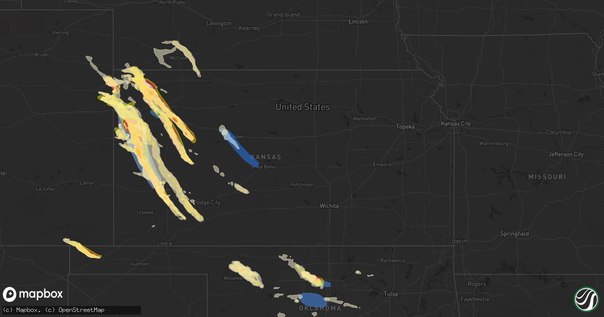
Hail Map in Kansas on August 7, 2023
Get this storm
August 7 map
$229
one time, instant access
Download today. No call, no setup
Keep the $229
Bought the map and want the full workflow? Apply the entire $229 to a subscription within 7 days. None of it is wasted.
Every map, not just this one
This buys you this map. Subscription and you get every map we run, in the markets you choose from a few cities to whole states to nationwide. Plus real-time alerts the moment a storm fires.
Contact data
Name, contact info, occupancy, even credit band for addresses in the footprint. You go from where it hit to who to call.
Become the source they trust
Unlimited branding weather history reports on demand. You already have the documented answer ready for the property owner, and you are the one who showed up with it.
Property data and RoofTrace estimates
Pull up any address you have got, its value and the exact code rules for that jurisdiction, straight from One Click Code. Then RoofTrace estimates the squares, pitch, and roof value, priced the way you price.
Storm reports in Kansas
Kansas
| Date | Description |
|---|---|
| 08/07/20236:59 PM CDT | Social media report with picture of hail to the size of golf balls. Time estimated from radar. |
| 08/07/20236:57 PM CDT | Mesonet station kkscolby28. |
| 08/07/20236:55 PM CDT | Mesonet station kkscolby35. |
| 08/07/20236:55 PM CDT | Reported via social media. Ping pong to tennis ball sized hail observed. Damage to a pickup truck and the entire east side of the house. Time estimated via radar. |
| 08/07/20236:53 PM CDT | A local report indicates 1.75 inch wind near 1 WNW Angelus |
| 08/07/20236:51 PM CDT | Social media report with picture of hail up to baseball sized covering the ground. Time estimated from radar. |
| 08/07/20236:48 PM CDT | Off-duty employee reported quarters in town. |
| 08/07/20236:46 PM CDT | Quarter sized hail reports at nws goodland office. |
| 08/07/20236:45 PM CDT | Social media report with picture of hail to ping pong ball in size. |
| 08/07/20236:45 PM CDT | A local report indicates 1.00 inch wind near 1 N Goodland |
| 08/07/20236:34 PM CDT | Reported via social media. Dime to quarter sized hail. Ended at 5:39 pm mdt. |
| 08/07/20236:19 PM CDT | Time estimated from radar. Reported via facebook. |
| 08/07/20236:08 PM CDT | Social media report of golf ball sized hail 3 miles north of colby. Time estimated from radar. |
| 08/07/20236:08 PM CDT | Social media report of quarter sized hail on cherokee drive in colby. Time estimated from radar. |
| 08/07/20236:08 PM CDT | Social media report with picture of golf ball sized hail. Time estimated from radar. |
| 08/07/20236:04 PM CDT | Quarter size hail reported in colby at 5:04 pm mdt. |
| 08/07/20236:01 PM CDT | Social media report of mostly pea sized hail... But with a picture of a few quarter sized hail. Time estimated from radar. |
| 08/07/20236:00 PM CDT | Hail lasted about 5 minutes. |
| 08/07/20235:49 PM CDT | Corrects previous hail report from 4 n colby. Ping pong to golf ball size hail 4 miles n of colby at 4:49 pm mdt. Egg sized hail observed at 4:53 pm mdt and still ongoi |
| 08/07/20235:49 PM CDT | Corrects previous hail report from 4 n colby. Corrects previous hail report from 4 n colby. Ping pong to golf ball size hail 4 miles n of colby at 4:49 pm mdt. Egg size |
| 08/07/20235:40 PM CDT | Reported via facebook. |
| 08/07/20235:28 PM CDT | Spotter reported hail that busted out windshield of car. Did also observe a rapidly rotating wall cloud. |
| 08/07/20235:22 PM CDT | Delayed report via social media. Hail ranging in size from pea to slightly larger than quarter sized. Most of the hail was dime to nickel in size. |
| 08/07/20235:22 PM CDT | Broken windshields on vehicle. |
| 08/07/20235:22 PM CDT | Broken windshields on vehicle. Ed covering the ground. Time estimated from radar. |
| 08/07/20235:15 PM CDT | Off-duty nws employee reported a measured 58 mph with handheld davis anemometer at 8 ft high. |
| 08/07/20235:10 PM CDT | Social media report with picture of ping pong ball sized hail stones. |
| 08/07/20234:55 PM CDT | Spotter reported golf ball size hail on road 17 around 1 mile south of the ks/ne border at 355 pm mdt. |
| 08/07/20234:47 PM CDT | Spotter reported ongoing dime to quarter sized hail that has been falling for 10 minutes as of 3:57 pm mt. |
| 08/07/20234:45 PM CDT | Social media report with picture of near 2 inch hail 6 miles north of bird city. |
| 08/07/20234:35 PM CDT | [landspout] brief landspout around 1 mile west of bird city at 3:35 pm mdt. |
| 08/07/20234:32 PM CDT | Delayed report. |
| 08/07/20234:30 PM CDT | Delayed report of 1 inch hail 9.5 miles north of bird city by big timber creek. 1.86 inches of rain reported from the storms. |
| 08/07/20234:19 PM CDT | Sporadic quarter sized hail observed on highway 161. |
| 08/06/202310:49 PM CDT | A local report indicates 1.75 inch wind near Plymell |
| 08/06/202310:32 PM CDT | A local report indicates 1.50 inch wind near 1 SE Holcomb |
| 08/06/202310:30 PM CDT | A local report indicates 1.00 inch wind near Holcomb |
| 08/06/20239:38 PM CDT | Corrects previous thunderstorm wind gust report from albert. Measured by a home weather station. |
| 08/06/20239:32 PM CDT | Measured by a home weather station in albert. |
| 08/06/20239:32 PM CDT | Measured by a home weather station in |
| 08/06/20239:25 PM CDT | Hail covering the road to a depth of one inc |
| 08/06/20239:25 PM CDT | Hail covering the road to a depth of one inch at the intersection of road v and highway 25 south of leoti. Hail was predominately dime to nickel sized... With a few lar |
| 08/06/20239:13 PM CDT | Social media report with pictures of hail ranging from an inch to 1.25 inches. |
| 08/06/20238:56 PM CDT | Awos station khys hays regional airport awos site. |
| 08/06/20238:55 PM CDT | A local report indicates 1.25 inch wind near Dighton |
| 08/06/20238:55 PM CDT | A local report indicates 1.75 inch wind near Dighton |
| 08/06/20238:45 PM CDT | Broken skylights were reported. |
| 08/06/20238:45 PM CDT | Corrects previous hail report from 10 nnw leoti. Spotter estimated quarter to golf ball sized hail. Time estimated. |
| 08/06/20238:37 PM CDT | Social media report with picture of hail stones varying from quarter to ping pong ball in size. Time estimated from radar. |
| 08/06/20238:35 PM CDT | A local report indicates 80 MPH wind near Ellis |
| 08/06/20238:30 PM CDT | Spotter estimated quarter to golf ball sized hail. Time estimated. |
| 08/06/20238:25 PM CDT | Time estimated via radar. |
| 08/06/20238:19 PM CDT | Time estimated by radar... Reported via facebook. |
| 08/06/20238:15 PM CDT | Social media report of golf ball sized hail 5 north of weskan. Time estimated by radar. |
| 08/06/20238:15 PM CDT | Mesonet station up840 9.0 w winona |
| 08/06/20238:05 PM CDT | Mesonet station kwlk1 wallace. 2m wind gust. |
| 08/06/20238:05 PM CDT | A local report indicates 1.75 inch wind near Wallace |
| 08/06/20238:02 PM CDT | Report from mping: 1-inch tree limbs broken; shingles blown off. |
| 08/06/20238:00 PM CDT | Caller reported golf ball sized hail with broken windows. Hail lasted 10-12 minutes from the start time. |
| 08/06/20237:58 PM CDT | Social media report of ping pong ball sized hail. Time estimated from radar. |
| 08/06/20237:57 PM CDT | 4 inch diameter tree limbs downed from pear tree. Wind gusts estimated at 60 mph at 6:57 pm mdt. |
| 08/06/20237:57 PM CDT | Summers646 davis weather station reported 65 mph gust. |
| 08/06/20237:44 PM CDT | Off-duty employee. |
| 08/06/20237:42 PM CDT | Delayed report of golf ball sized hail in grinnell. |
| 08/06/20237:40 PM CDT | Delayed report of golf ball sized that broke out all of the north facing windows. Due to a broken window... The basement flooded. Potentially wind driven hail event. Mu |
| 08/06/20237:35 PM CDT | Accumulating golf ball sized hail reported. Time estimated. |
| 08/06/20237:35 PM CDT | Delayed report. Accumulating hail observed. |
| 08/06/20237:34 PM CDT | Spotter reported lots of golf ball sized hail. Time estimated from radar. |
| 08/06/20237:34 PM CDT | Emergency manager reported damage to nearly all buildings in town on the north-facing side. Windows on the north-facing side are all busted out. |
| 08/06/20237:30 PM CDT | Delayed report via social media of golf ball... And slightly larger... Hail that fell around 7:30 pm cdt. Around 3 inches of rain were also reported from the storms. Tr |
| 08/06/20237:27 PM CDT | A local report indicates 66 MPH wind near 16 S Ruleton |
| 08/06/20237:24 PM CDT | Report from mping: quarter |
| 08/06/20237:24 PM CDT | Ongoing quarter sized hail. |
| 08/06/20237:24 PM CDT | A local report indicates 1.00 inch wind near Oakley |
| 08/06/20237:22 PM CDT | Reported via social media. |
| 08/06/20237:22 PM CDT | Dime to half dollar sized hail observed. |
| 08/06/20237:20 PM CDT | Social media report of pea to quarter sized hail. Time estimated from radar. |
| 08/06/20237:18 PM CDT | Report from mping: quarter |
| 08/06/20237:09 PM CDT | Asos station kgld goodland. |
| 08/06/20237:09 PM CDT | Corrects previous hail report from 1 nne goodland. |
| 08/06/20237:03 PM CDT | Report from mping: hen egg |
| 08/06/20237:00 PM CDT | Emergency manager reported damage to nearly all buildings in town on the north-facing side. Windows on the north-facing side are all busted out. |
| 08/06/20237:00 PM CDT | Report from mping: golf ball |
| 08/06/20237:00 PM CDT | Reported via social media. Golf ball to tennis ball sized hail observed. |
All States Impacted by Hail Map on August 7, 2023
Cities Impacted by Hail Map on August 7, 2023
- Whiteville, TN
- Somerville, TN
- Bolivar, TN
- Hickory Valley, TN
- Saulsbury, TN
- Middleton, TN
- Hornsby, TN
- Bethel Springs, TN
- Selmer, TN
- Pocahontas, TN
- Ramer, TN
- Guys, TN
- Lutts, TN
- Counce, TN
- Adamsville, TN
- Savannah, TN
- Shiloh, TN
- Michie, TN
- Stantonville, TN
- Collinwood, TN
- Olivehill, TN
- Crump, TN
- Cypress Inn, TN
- Waynesboro, TN
- Coolville, OH
- Little Hocking, OH
- Shelbyville, KY
- Midway, KY
- Frankfort, KY
- Bagdad, KY
- Stamping Ground, KY
- Georgetown, KY
- Shelbyville, TN
- Unionville, TN
- Bell Buckle, TN
- Beechgrove, TN
- Wartrace, TN
- Manchester, TN
- Morrison, TN
- Mcminnville, TN
- Rock Island, TN
- Pikeville, TN
- Spencer, TN
- Dunlap, TN
- Reedsville, WV
- Arthurdale, WV
- Kingwood, WV
- Albright, WV
- Independence, WV
- Bruceton Mills, WV
- Terra Alta, WV
- Duck, WV
- Frametown, WV
- Gassaway, WV
- Mineral Wells, WV
- Walker, WV
- Elizabeth, WV
- Big Pool, MD
- Clear Spring, MD
- Huntington, WV
- Barboursville, WV
- Rock Cave, WV
- French Creek, WV
- Pickens, WV
- Helvetia, WV
- Hazel Green, AL
- New Market, AL
- Estillfork, AL
- Scottsboro, AL
- Stevenson, AL
- Sherwood, TN
- South Pittsburg, TN
- Bridgeport, AL
- Bryant, AL
- Flat Rock, AL
- Guild, TN
- Chattanooga, TN
- Wildwood, GA
- Jasper, TN
- Trenton, GA
- Whitwell, TN
- Higdon, AL
- Dayton, TN
- Rockwood, TN
- Grandview, TN
- Spring City, TN
- Evensville, TN
- Crossville, TN
- Crab Orchard, TN
- Woodbury, TN
- Bradyville, TN
- Doyle, TN
- Quebeck, TN
- Sparta, TN
- Walling, TN
- Smithville, TN
- Christiana, TN
- Athens, TN
- Niota, TN
- Sweetwater, TN
- Ten Mile, TN
- Madisonville, TN
- Kingston, TN
- Decatur, TN
- Philadelphia, TN
- Loudon, TN
- Greenback, TN
- Oak Ridge, TN
- Harriman, TN
- Knoxville, TN
- Lenoir City, TN
- Louisville, TN
- Vonore, TN
- Farragut, TN
- Friendsville, TN
- Mill Creek, WV
- McHenry, MD
- Oakland, MD
- Friendsville, MD
- Accident, MD
- Grantsville, MD
- Swanton, MD
- Barton, MD
- Newport, TN
- White Pine, TN
- Bybee, TN
- Morristown, TN
- Mohawk, TN
- Greeneville, TN
- Ona, WV
- Milton, WV
- Culloden, WV
- Maryville, TN
- Mercersburg, PA
- Parrottsville, TN
- Hancock, MD
- Rockport, WV
- West Union, WV
- Morgantown, WV
- Drummonds, TN
- Grand Junction, TN
- Oakdale, TN
- Rienzi, MS
- Heidrick, KY
- Flat Lick, KY
- Cannon, KY
- Bimble, KY
- Gray, KY
- Barbourville, KY
- La Follette, TN
- Jacksboro, TN
- Berkeley Springs, WV
- Fairmont, WV
- Rocky Top, TN
- Andersonville, TN
- Salyersville, KY
- Arjay, KY
- Luttrell, TN
- Powder Springs, TN
- Blaine, TN
- Maynardville, TN
- Leon, WV
- Tyrone, PA
- Warriors Mark, PA
- Walton, WV
- Jamestown, TN
- Proctorville, OH
- Lavalette, WV
- Kenova, WV
- Thurman, OH
- Vinton, OH
- Oak Hill, OH
- Portland, OH
- Racine, OH
- Long Bottom, OH
- Parkersburg, WV
- Davisville, WV
- Medon, TN
- Ravenswood, WV
- Millwood, WV
- Wallace, WV
- Lumberport, WV
- Saint Albans, WV
- Poca, WV
- Winfield, WV
- Charleston, WV
- Nitro, WV
- Seaman, OH
- Winchester, OH
- Chloe, WV
- Nebo, WV
- Newton, WV
- Slanesville, WV
- Paw Paw, WV
- Hedgesville, WV
- Hillsboro, OH
- Hohenwald, TN
- Centerville, TN
- Linden, TN
- Albany, KY
- Cherokee, AL
- Salem, WV
- New Milton, WV
- Lobelville, TN
- Fisher, AR
- Heiskell, TN
- Prichard, WV
- Catlettsburg, KY
- Lavaca, AR
- Bloomery, WV
- Amma, WV
- Left Hand, WV
- Looneyville, WV
- Alma, WV
- Lexington, TN
- Darden, TN
- Huron, TN
- Beech Bluff, TN
- Newburg, WV
- Bidwell, OH
- Moscow, TN
- Stoney Fork, KY
- Hinkle, KY
- Corbin, KY
- Scalf, KY
- Walker, KY
- Belleville, WV
- Syracuse, OH
- Sandyville, WV
- Letart, WV
- Hartford, WV
- West Columbia, WV
- Mason, WV
- New Haven, WV
- Glenwood, WV
- Robbins, TN
- Big Cove Tannery, PA
- Millington, TN
- Amagon, AR
- Norris, TN
- McCrory, AR
- Cherry Valley, AR
- Hickory Ridge, AR
- Newport, AR
- Earle, AR
- Harrisburg, AR
- Weiner, AR
- Marked Tree, AR
- Cross Junction, VA
- Parsons, TN
- Lucasville, OH
- Minford, OH
- Clendenin, WV
- Gandeeville, WV
- Spencer, WV
- Charleston, AR
- Jackson, TN
- Corryton, TN
- Midway, TN
- Mannington, WV
- Iuka, MS
- Advent, WV
- Kenna, WV
- New Albany, MS
- Rutledge, TN
- Briceville, TN
- Clinton, TN
- Pioneer, TN
- Strawberry Plains, TN
- Caryville, TN
- Mascot, TN
- Sharps Chapel, TN
- Brighton, TN
- Mason, TN
- Arlington, TN
- Stanton, TN
- Olive Branch, MS
- Pennsboro, WV
- Middlebourne, WV
- Abbeville, MS
- Saint Marys, WV
- Oxford, MS
- Williamsburg, KY
- Rockholds, KY
- Woodbine, KY
- Patriot, OH
- Gallipolis, OH
- Byrdstown, TN
- Henderson, TN
- Jacksonburg, WV
- Center Point, WV
- Cairo, WV
- Pullman, WV
- Ellenboro, WV
- De Valls Bluff, AR
- Shade, OH
- Guysville, OH
- Washington, WV
- Worthington, WV
- Shinnston, WV
- Helenwood, TN
- Florence, AL
- Waverly, WV
- Toone, TN
- Holly Springs, MS
- Byhalia, MS
- Allardt, TN
- Huntsville, TN
- Huntsville, AL
- Madison, AL
- Pinson, TN
- Celina, TN
- Selbyville, WV
- Kanawha Head, WV
- Crawford, WV
- Ireland, WV
- Heaters, WV
- Hacker Valley, WV
- Sutton, WV
- Flatwoods, WV
- Napier, WV
- Orma, WV
- Memphis, TN
- Rosedale, WV
- Shock, WV
- South Webster, OH
- Oakland, TN
- Atoka, TN
- Crawfordsville, AR
- Covington, TN
- Rossville, TN
- Marion, AR
- Eads, TN
- Collierville, TN
- Turrell, AR
- Chesapeake, OH
- South Point, OH
- Lesage, WV
- Crown City, OH
- Cottageville, WV
- Tishomingo, MS
- Scotts Hill, TN
- Bath Springs, TN
- Hagerstown, MD
- Maugansville, MD
- Rossville, GA
- Chickamauga, GA
- Rising Fawn, GA
- Lookout Mountain, TN
- Ringgold, GA
- Rock Spring, GA
- Fort Oglethorpe, GA
- Lookout Mountain, GA
- Flintstone, GA
- Blue Springs, MS
- Tupelo, MS
- Saltillo, MS
- Guntown, MS
- Mooreville, MS
- Rocky Face, GA
- Tunnel Hill, GA
- Cohutta, GA
- Apison, TN
- Ooltewah, TN
- New Market, TN
- Alcoa, TN
- Rockford, TN
- Powell, TN
- Walland, TN
- Seymour, TN
- Kodak, TN
- Flag Pond, TN
- Erwin, TN
- Mars Hill, NC
- Burnsville, NC
- Green Mountain, NC
- Sevierville, TN
- Dandridge, TN
- Jefferson City, TN
- Talbott, TN
- Chatsworth, GA
- Dalton, GA
- Crandall, GA
- Cisco, GA
- Hurricane, WV
- Scott Depot, WV
- Red House, WV
- Boalsburg, PA
- Centre Hall, PA
- Spring Mills, PA
- Coburn, PA
- Mosheim, TN
- Lonaconing, MD
- Waynesboro, PA
- State Line, PA
- Greencastle, PA
- Martinsburg, WV
- Falling Waters, WV
- Williamsport, MD
- Fairplay, MD
- Boonsboro, MD
- Funkstown, MD
- Smithsburg, MD
- Trout Run, PA
- Hamlin, WV
- Tornado, WV
- Sod, WV
- Marshall, NC
- Weaverville, NC
- Del Rio, TN
- Hot Springs, NC
- Chuckey, TN
- Unicoi, TN
- Afton, TN
- Barnardsville, NC
- Bakersville, NC
- Spruce Pine, NC
- Newland, NC
- Woodward, PA
- Milroy, PA
- Millmont, PA
- Epworth, GA
- Blue Ridge, GA
- Dugspur, VA
- Indian Valley, VA
- Willis, VA
- Hillsville, VA
- Hiawassee, GA
- Hayesville, NC
- Clayton, GA
- Tiger, GA
- Rabun Gap, GA
- Franklin, NC
- Otto, NC
- Dillard, GA
- Craigsville, VA
- Swoope, VA
- West Augusta, VA
- Sabillasville, MD
- Emmitsburg, MD
- Cascade, MD
- Thurmont, MD
- Taneytown, MD
- Shunk, PA
- Scaly Mountain, NC
- Highlands, NC
- Cheyenne, WY
- Burns, WY
- Albin, WY
- Staunton, VA
- Middlebrook, VA
- Fort Defiance, VA
- Verona, VA
- Churchville, VA
- Grottoes, VA
- Crimora, VA
- Briggsdale, CO
- Waynesboro, VA
- New Raymer, CO
- Grover, CO
- Stoneham, CO
- Fishersville, VA
- Alum Creek, WV
- South Charleston, WV
- Fort Huachuca, AZ
- Hereford, AZ
- Sierra Vista, AZ
- Mountain Rest, SC
- Cashiers, NC
- Salem, SC
- Brevard, NC
- Sapphire, NC
- Taylors, SC
- Greenville, SC
- Greer, SC
- Duncan, SC
- Moore, SC
- Woodruff, SC
- Wellford, SC
- Spartanburg, SC
- Littlestown, PA
- Gettysburg, PA
- Westminster, MD
- Hanover, PA
- Merino, CO
- Haigler, NE
- Parks, NE
- Atlanta, GA
- Norcross, GA
- Lilburn, GA
- Tucker, GA
- Bird City, KS
- Saint Francis, KS
- Benkelman, NE
- Max, NE
- Stratton, NE
- Palisade, NE
- Heflin, AL
- Fruithurst, AL
- Muscadine, AL
- Buchanan, GA
- Tallapoosa, GA
- Bremen, GA
- Bowdon, GA
- Ranburne, AL
- Waco, GA
- Carrollton, GA
- Pauline, SC
- Roebuck, SC
- Pacolet, SC
- Jonesville, SC
- Granite Falls, NC
- Lenoir, NC
- Valdese, NC
- Morganton, NC
- Drexel, NC
- Hudson, NC
- Lawndale, NC
- Connelly Springs, NC
- Hildebran, NC
- Hickory, NC
- Newton, NC
- Vale, NC
- Claremont, NC
- Conover, NC
- Sherrills Ford, NC
- Maiden, NC
- Catawba, NC
- Denver, NC
- Lincolnton, NC
- Iron Station, NC
- Taylorsville, NC
- Hiddenite, NC
- Stony Point, NC
- Crozet, VA
- Free Union, VA
- Earlysville, VA
- Dyke, VA
- Barboursville, VA
- Ruckersville, VA
- Charlottesville, VA
- McDonald, KS
- Culbertson, NE
- Hayes Center, NE
- Stanardsville, VA
- Louisa, VA
- Atwood, KS
- Gordonsville, VA
- Manchester, MD
- Hampstead, MD
- Otis, CO
- Akron, CO
- Yuma, CO
- Glen Rock, PA
- Freeland, MD
- New Freedom, PA
- Burlington, CO
- Parkton, MD
- Shrewsbury, PA
- Stewartstown, PA
- New Park, PA
- White Hall, MD
- Airville, PA
- Felton, PA
- Brogue, PA
- Pequea, PA
- Fawn Grove, PA
- Holtwood, PA
- Drumore, PA
- Delta, PA
- New Providence, PA
- Willow Street, PA
- Conestoga, PA
- Strasburg, PA
- Quarryville, PA
- Kirkwood, PA
- Pylesville, MD
- Rising Sun, MD
- Nottingham, PA
- Peach Bottom, PA
- Whiteford, MD
- Conowingo, MD
- Oxford, PA
- Paradise, PA
- Ronks, PA
- Christiana, PA
- West Grove, PA
- Lincoln University, PA
- Atglen, PA
- Parkesburg, PA
- Cochranville, PA
- Kinzers, PA
- Gap, PA
- Yoder, WY
- Hawk Springs, WY
- Orange, VA
- Germantown, MD
- Sterling, VA
- Ashburn, VA
- Poolesville, MD
- Great Falls, VA
- Potomac, MD
- Dickerson, MD
- Beallsville, MD
- Leesburg, VA
- Gaithersburg, MD
- Huddleston, VA
- Wingina, VA
- Howardsville, VA
- Lynchburg, VA
- Evington, VA
- Stuart, VA
- Rustburg, VA
- Martinsville, VA
- Troy, VA
- Lawsonville, NC
- Sandy Level, VA
- Scottsville, VA
- Palmyra, VA
- Critz, VA
- Rocky Mount, VA
- Lynch Station, VA
- Patrick Springs, VA
- Gladstone, VA
- Appomattox, VA
- Glade Hill, VA
- Penhook, VA
- Concord, VA
- Bassett, VA
- Buckingham, VA
- Rockville, MD
- Boyds, MD
- Damascus, MD
- Sandy Spring, MD
- Clarksburg, MD
- Woodbine, MD
- Montgomery Village, MD
- Derwood, MD
- Silver Spring, MD
- Brookeville, MD
- Olney, MD
- Washington Grove, MD
- Mount Airy, MD
- Glenelg, MD
- Ashton, MD
- West Friendship, MD
- Cooksville, MD
- Clarksville, MD
- Dayton, MD
- Ellicott City, MD
- Highland, MD
- Brinklow, MD
- Glenwood, MD
- Clifton, VA
- Centreville, VA
- Bristow, VA
- Nokesville, VA
- Manassas, VA
- Fairfax Station, VA
- Fairfax, VA
- Railroad, PA
- Lancaster, PA
- Millersville, PA
- Gordonville, PA
- Lagrange, WY
- Coatesville, PA
- Chester Springs, PA
- Honey Brook, PA
- Glenmoore, PA
- West Chester, PA
- Avondale, PA
- Kennett Square, PA
- Bird In Hand, PA
- Elverson, PA
- Intercourse, PA
- Exton, PA
- New Holland, PA
- Downingtown, PA
- Thorndale, PA
- East Earl, PA
- Narvon, PA
- Morgantown, PA
- Idalia, CO
- Colby, KS
- Kanorado, KS
- Chadds Ford, PA
- Toughkenamon, PA
- Glen Mills, PA
- Cheyney, PA
- Thornton, PA
- Maywood, NE
- McCook, NE
- Media, PA
- Springfield, PA
- Newtown Square, PA
- Immaculata, PA
- Malvern, PA
- Wayne, PA
- King Of Prussia, PA
- Collegeville, PA
- Berwyn, PA
- Oaks, PA
- Pottstown, PA
- Paoli, PA
- Broomall, PA
- Phoenixville, PA
- Royersford, PA
- Mont Clare, PA
- Norristown, PA
- Devon, PA
- Spring City, PA
- Villanova, PA
- Indianola, NE
- Curtis, NE
- Lansdale, PA
- Havertown, PA
- Haverford, PA
- Skippack, PA
- Schwenksville, PA
- Conshohocken, PA
- Bridgeport, PA
- Harleysville, PA
- Blue Bell, PA
- Bryn Mawr, PA
- Souderton, PA
- Hatfield, PA
- Plymouth Meeting, PA
- Wynnewood, PA
- Drexel Hill, PA
- Narberth, PA
- Ardmore, PA
- Upper Darby, PA
- Gladwyne, PA
- Bala Cynwyd, PA
- Lafayette Hill, PA
- North Wales, PA
- Philadelphia, PA
- Merion Station, PA
- Levant, KS
- Wray, CO
- Spring House, PA
- Oreland, PA
- Line Lexington, PA
- Doylestown, PA
- Ambler, PA
- Horsham, PA
- Chalfont, PA
- Warrington, PA
- Colmar, PA
- Fort Washington, PA
- Flourtown, PA
- Montgomeryville, PA
- Glenside, PA
- Gwynedd, PA
- Hatboro, PA
- Willow Grove, PA
- Elkins Park, PA
- Bryn Athyn, PA
- Wyncote, PA
- Richboro, PA
- Dresher, PA
- Feasterville Trevose, PA
- Warminster, PA
- Furlong, PA
- Huntingdon Valley, PA
- Jamison, PA
- Abington, PA
- Cheltenham, PA
- Bensalem, PA
- Southampton, PA
- Jenkintown, PA
- Spotsylvania, VA
- Partlow, VA
- Alliance, NE
- Ellsworth, NE
- Hay Springs, NE
- Oshkosh, NE
- Ashby, NE
- Hyannis, NE
- Gem, KS
- Woodford, VA
- Fredericksburg, VA
- Ruther Glen, VA
- Edson, KS
- Goodland, KS
- Rexford, KS
- Levittown, PA
- Langhorne, PA
- Newtown, PA
- Morrisville, PA
- Fairless Hills, PA
- New Hope, PA
- Washington Crossing, PA
- Trenton, NJ
- Titusville, NJ
- Lambertville, NJ
- Danbury, NE
- Bartley, NE
- Lebanon, NE
- Wilsonville, NE
- Port Royal, VA
- Bowling Green, VA
- Lakeside, NE
- Caret, VA
- Lewellen, NE
- Harrisburg, NE
- Loretto, VA
- Colonial Beach, VA
- Hightstown, NJ
- Lawrence Township, NJ
- Windsor, NJ
- Robbinsville, NJ
- Pennington, NJ
- Hopewell, NJ
- Skillman, NJ
- Princeton Junction, NJ
- Ringoes, NJ
- Princeton, NJ
- Gaffney, SC
- Union, SC
- Sharon, SC
- Hickory Grove, SC
- McConnells, SC
- York, SC
- Rock Hill, SC
- Chester, SC
- Edgemoor, SC
- Orviston, PA
- McConnellsburg, PA
- Collinsville, AL
- Danielsville, GA
- Horton, AL
- Blountsville, AL
- Kim, CO
- Brilliant, AL
- Hamilton, AL
- Guin, AL
- Tennille, GA
- Upper Marlboro, MD
- Capitol Heights, MD
- Hyattsville, MD
- Wheatland, WY
- Greenbelt, MD
- Bladensburg, MD
- College Park, MD
- Mount Rainier, MD
- Lanham, MD
- Brentwood, MD
- Riverdale, MD
- Washington, DC
- Bingham, NE
- Ganado, AZ
- Ault, CO
- Amissville, VA
- Flint Hill, VA
- Marshall, VA
- Warrenton, VA
- Hume, VA
- Decatur, GA
- Chevy Chase, MD
- Takoma Park, MD
- Elkview, WV
- West Hamlin, WV
- Dunbar, WV
- Branchland, WV
- Millport, AL
- Mineral, VA
- Belden, MS
- Points, WV
- Augusta, WV
- Romney, WV
- Maysville, WV
- Petersburg, WV
- Lahmansville, WV
- Le Roy, WV
- Smithville, MS
- Snellville, GA
- Winslow, AZ
- Happy Jack, AZ
- Sedona, AZ
- Fort Payne, AL
- The Plains, VA
- Doe Hill, VA
- Monterey, VA
- McDowell, VA
- Phyllis, KY
- Kimper, KY
- Raccoon, KY
- Pikeville, KY
- Russellville, AL
- Shepherdstown, WV
- Eldridge, AL
- Dawsonville, GA
- Sugar Grove, WV
- Warfordsburg, PA
- Clearville, PA
- Artemas, PA
- Belleville, PA
- Reedsville, PA
- Huntingdon, PA
- Lewistown, PA
- Yeagertown, PA
- Jasper, AL
- Nauvoo, AL
- Carbon Hill, AL
- Sardis, TN
- Saltillo, TN
- Boaz, AL
- Gerrardstown, WV
- Bunker Hill, WV
- Hurley, VA
- Grundy, VA
- East Lynn, WV
- Wayne, WV
- Little Birch, WV
- Cowen, WV
- Elkton, VA
- Shenandoah, VA
- Harrisonburg, VA
- Keezletown, VA
- Fulton, MS
- Anderson, SC
- Pendleton, SC
- Farmington, WV
- Carolina, WV
- Enterprise, WV
- Vernon, AL
- Ivydale, WV
- Wallback, WV
- Fairfield, PA
- Fort Loudon, PA
- Deerfield, VA
- Fairburn, GA
- Spruce Pine, AL
- Hodges, AL
- Phil Campbell, AL
- Adger, AL
- Oakman, AL
- Bessemer, AL
- Detroit, AL
- Green Spring, WV
- Springfield, WV
- Lula, GA
- West Liberty, KY
- Kannapolis, NC
- Cornelius, NC
- Huntersville, NC
- Concord, NC
- Mooresville, NC
- Davidson, NC
- Cartersville, GA
- Inwood, WV
- Glengary, WV
- White, GA
- Graysville, AL
- Mount Olive, AL
- Quinton, AL
- Northport, AL
- Palestine, WV
- Huntly, VA
- Jeffersonton, VA
- Washington, VA
- Winfield, PA
- Selinsgrove, PA
- Northumberland, PA
- Mifflinburg, PA
- Lewisburg, PA
- New Berlin, PA
- Riverside, PA
- Danville, PA
- Sunbury, PA
- Jacksonville, AL
- Mount Solon, VA
- Seven Valleys, PA
- Nettleton, MS
- Amory, MS
- Shannon, MS
- Plantersville, MS
- Delaplane, VA
- Trenton, NE
- Blaine, KY
- Flatgap, KY
- Louisa, KY
- Dunmore, WV
- Head Waters, VA
- Marlinton, WV
- Millboro, VA
- Saint Thomas, PA
- Chambersburg, PA
- Upperstrasburg, PA
- Toomsboro, GA
- San Simon, AZ
- Mount Sterling, KY
- Owingsville, KY
- Olympia, KY
- Frenchburg, KY
- Wellington, KY
- Salt Lick, KY
- Morehead, KY
- Englewood, TN
- McClure, PA
- Beaver Springs, PA
- Keyser, WV
- Fort Ashby, WV
- Procious, WV
- Red Bay, AL
- Bowie, AZ
- Aragon, NM
- Bethlehem, GA
- Cedarbluff, MS
- West Point, MS
- Tremont, MS
- Warrior, AL
- Hayden, AL
- Ridgeley, WV
- Cumberland, MD
- Oldtown, MD
- Reserve, NM
- Mehoopany, PA
- Hartwell, GA
- Bowersville, GA
- River, KY
- Stambaugh, KY
- Paintsville, KY
- Tutor Key, KY
- Le Raysville, PA
- Laceyville, PA
- Wyalusing, PA
- Montrose, PA
- Lawton, PA
- Stevensville, PA
- Temple, GA
- Crossville, AL
- Willow Wood, OH
- Scottown, OH
- Little Orleans, MD
- Lithia Springs, GA
- Gainesville, GA
- Clermont, GA
- Canton, GA
- Ripley, WV
- Adamsville, AL
- Mulga, AL
- Townville, SC
- Seneca, SC
- Durbin, WV
- Fannettsburg, PA
- Irwinton, GA
- McIntyre, GA
- Keaton, KY
- Marietta, SC
- Franklin, WV
- Brandywine, WV
- Elfrida, AZ
- Dora, AL
- Fraziers Bottom, WV
- Buffalo, WV
- Petroleum, WV
- Dallas, GA
- Morganton, GA
- Blairsville, GA
- Pickens, SC
- Rutherfordton, NC
- Forest City, NC
- Piedmont, SC
- Liberty, SC
- Williamston, SC
- Phelps, KY
- Bloomington, MD
- Westernport, MD
- Comer, GA
- Hull, GA
- Pennsylvania Furnace, PA
- Cornelia, GA
- Alto, GA
- Belmont, MS
- Dennis, MS
- Rocky Ridge, MD
- Myersville, MD
- Sharpsburg, MD
- Mill Spring, NC
- Columbus, NC
- Tryon, NC
- Mooresboro, NC
- Ellenboro, NC
- Sulligent, AL
- Waterloo, OH
- Dawson, AL
- Douglasville, GA
- Warm Springs, VA
- Hot Springs, VA
- Linville, VA
- Fence Lake, NM
- Timberville, VA
- Broadway, VA
- Frostburg, MD
- Goshen, VA
- Everett, PA
- Elberton, GA
- Needmore, PA
- Ware Shoals, SC
- Honea Path, SC
- Donalds, SC
- Evans, WV
- Cubero, NM
- Laguna, NM
- Kearneysville, WV
- Limestone, TN
- Hustontown, PA
- Harrisonville, PA
- Tuscumbia, AL
- Big Bend, WV
- Brohard, WV
- Woodsboro, MD
- Keymar, MD
- Hiwassee, VA
- Sykesville, MD
- Owings Mills, MD
- Reisterstown, MD
- Laramie, WY
- Great Cacapon, WV
- Rawlings, MD
- Flintstone, MD
- Tunnelton, WV
- Levels, WV
- Newnan, GA
- Moreland, GA
- Grantville, GA
- Tombstone, AZ
- Port Matilda, PA
- Wharton, WV
- Naoma, WV
- Oceana, WV
- Arnoldsburg, WV
- Millstone, WV
- Smyrna, GA
- Rixeyville, VA
- Bentonville, VA
- Rileyville, VA
- Front Royal, VA
- Catlett, VA
- Markham, VA
- Chester Gap, VA
- Linden, VA
- Pie Town, NM
- Haleyville, AL
- Sunset, SC
- Ranger, GA
- Fairmount, GA
- Calhoun, GA
- Bushnell, NE
- Max Meadows, VA
- Austinville, VA
- Barren Springs, VA
- Pontotoc, MS
- Houlka, MS
- Logan, AL
- Cullman, AL
- Sophia, WV
- Lester, WV
- Slab Fork, WV
- Ravencliff, WV
- Glen Fork, WV
- Keedysville, MD
- Wittensville, KY
- Staffordsville, KY
- Oil Springs, KY
- Sitka, KY
- Harold, KY
- Parrish, AL
- Douglas, WY
- Beckley, WV
- Stanley, VA
- Hamilton, MS
- Wartburg, TN
- Oliver Springs, TN
- Lancing, TN
- Folsom, WV
- New Market, VA
- Luray, VA
- Flowery Branch, GA
- Albertville, AL
- Addison, AL
- Houston, AL
- Fairdale, WV
- Glen Daniel, WV
- Arnett, WV
- Saxon, WV
- Pelzer, SC
- Belton, SC
- Starr, SC
- Greenwood Springs, MS
- Rouzerville, PA
- Winchester, VA
- Blue Ridge Summit, PA
- Charles Town, WV
- Burnt Cabins, PA
- Ranson, WV
- Fort Littleton, PA
- Spring Grove, PA
- Clear Brook, VA
- Three Springs, PA
- Southside, WV
- Thaxton, MS
- Ecru, MS
- Suitland, MD
- Andrews Air Force Base, MD
- District Heights, MD
- Bowie, MD
- Temple Hills, MD
- Lothian, MD
- Easley, SC
- Loganville, GA
- Oxford, GA
- Baldwyn, MS
- Marietta, MS
- New Site, MS
- Booneville, MS
- Beaverton, AL
- Jackson, KY
- Double Springs, AL
- Martin, GA
- Monroe, GA
- Dacula, GA
- Dewy Rose, GA
- Bowman, GA
- Conyers, GA
- Kennedy, AL
- Sunbright, TN
- Fayette, AL
- Columbus, MS
- Caledonia, MS
- Okolona, MS
- Ashton, WV
- Piedmont, AL
- Fountain Inn, SC
- Gray Court, SC
- Middletown, MD
- Frederick, MD
- Rohrersville, MD
- Alpine, TN
- Magdalena, NM
- Jonesborough, TN
- Telford, TN
- Birmingham, AL
- Docena, AL
- Quemado, NM
- Reedy, WV
- Beavertown, PA
- State College, PA
- Kitts Hill, OH
- Pedro, OH
- Lawrenceville, GA
- Lithonia, GA
- Creston, WV
- Castleton, VA
- Davisboro, GA
- Sandersville, GA
- Harrison, GA
- Gay, WV
- Given, WV
- Clearfield, KY
- Hagerhill, KY
- Anniston, AL
- Apple Grove, WV
- Gallipolis Ferry, WV
- Villa Rica, GA
- Eaton, NY
- Exchange, WV
- Liberty, WV
- Diana, WV
- Burnsville, WV
- Tallmansville, WV
- Decaturville, TN
- Morrisville, NY
- Munnsville, NY
- Whitman, NE
- Arthur, NE
- Susquehanna, PA
- Brewster, KS
- Oakley, KS
- Hoxie, KS
- Grinnell, KS
- Monument, KS
- Deposit, NY
- Franklin Park, NJ
- North Brunswick, NJ
- Belle Mead, NJ
- Hillsborough, NJ
- Rocky Hill, NJ
- Somerset, NJ
- Cranbury, NJ
- Kingston, NJ
- Monroe Township, NJ
- Kendall Park, NJ
- Monmouth Junction, NJ
- Dayton, NJ
- Plainsboro, NJ
- Richburg, SC
- Fort Lawn, SC
- Catawba, SC
- Turin, NY
- Grainfield, KS
- Sharon Springs, KS
- West Leyden, NY
- Gove, KS
- Roopville, GA
- Winston, GA
- Whitesburg, GA
- Pine Ridge, SD
- Rushville, NE
- Chadron, NE
- Wallace, KS
- Winona, KS
- Weskan, KS
- Park, KS
- Boise City, OK
- Kenton, OK
- Shoshoni, WY
- Quinter, KS
- Leoti, KS
- Healy, KS
- Dighton, KS
- Tribune, KS
- Keyes, OK
- Ellis, KS
- Ogallah, KS
- McCracken, KS
- Hays, KS
- Schoenchen, KS
- Elsie, NE
- Wallace, NE
- Marienthal, KS
- Deerfield, KS
- Liebenthal, KS
- La Crosse, KS
- Otis, KS
- Bison, KS
- Olmitz, KS
- Albert, KS
- Rush Center, KS
- Hoisington, KS
- Great Bend, KS
- Lakin, KS
- Holcomb, KS
- Garden City, KS
- Sublette, KS
- Copeland, KS
- Seymour, TX
- Marsland, NE
- Glenrock, WY
- Afton, VA
- Lovington, NM
- Hobbs, NM
- Delmar, DE
- Genoa, CO
- Limon, CO
- Landenberg, PA
- North East, MD
- Elkton, MD
- Great Mills, MD
- Drayden, MD
- Lexington Park, MD
- Leonardtown, MD
- Callaway, MD
- Park Hall, MD
- Valley Lee, MD
- Nicholson, PA
- Hanceville, AL
- Milledgeville, GA
- Tilghman, MD
- Sherwood, MD
- Neavitt, MD
- Yemassee, SC
- Walterboro, SC
- Whitney, NE
- Crawford, NE
- Singers Glen, VA
- Holyoke, CO
- Marion, SC
- Florence, SC
- Pamplico, SC
- Effingham, SC
- Plains, TX
- North Platte, NE
- Keystone, NE
- Paxton, NE
- Ogallala, NE
- Culpeper, VA
- Lignum, VA
- Richardsville, VA
- Goldvein, VA
- Sumerduck, VA
- Elkwood, VA
- Stevensburg, VA
- Pine Bluffs, WY
- Torrington, WY
- Harrison, NE
- Clifton, AZ
- Queenstown, MD
- Chester, MD
- Grasonville, MD
- Easton, MD
- Royal Oak, MD
- Pinewood, SC
- Sparta, GA
- Fort Valley, GA
- Safford, AZ
- Brookhaven, PA
- Aston, PA
- Trappe, MD
- Cambridge, MD
- Flagler, CO
- Hugo, CO
- Kit Carson, CO
- Churchton, MD
- Dunkirk, MD
- Harwood, MD
- Deale, MD
- Tracys Landing, MD
- West River, MD
- Gordon, GA
- Wellfleet, NE
- Pritchett, CO
- Monetta, SC
- Batesburg, SC
- Merriman, NE
- Animas, NM
- Warne, NC
- Brasstown, NC
- Pinon, NM
- Dell City, TX
- Eckley, CO
- Portales, NM
- Muleshoe, TX
- Norcatur, KS
- Bozman, MD
- Franklin, GA
- Bishopville, SC
- Camden, SC
- Cassatt, SC
- Covington, GA
- East Dublin, GA
- Rio, WV
- Laurens, SC
- Broadway, NC
- Bedford, PA
- Ellerbe, NC
- McCormick, SC
- Rapidan, VA
- Unionville, VA
- Sudan, TX
- Seminole, TX
- Aiken, SC
- Orangeburg, SC
- North, SC
- Saint Matthews, SC
- Forsyth, GA
- Musella, GA
- Macon, GA
- Johnston, SC
- Tyaskin, MD
- Quantico, MD
- Bivalve, MD
- Brownfield, TX
- Oconto, NE
- Hartsville, SC
- Patrick, SC
- Nanticoke, MD
- Vienna, MD
- Eden, MD
- Hebron, MD
- Salisbury, MD
- Mickleton, NJ
- Latta, SC
- Sellers, SC
- Somerset, VA
- Willcox, AZ
- Finksburg, MD
- Tryon, NE
- Mount Royal, NJ
- Thorofare, NJ
- Woodbury, NJ
- Woodbury Heights, NJ
- Wenonah, NJ
- Mantua, NJ
- Sewell, NJ
- Blackwood, NJ
- Lake Bronson, MN
- Winder, GA
- Hop Bottom, PA
- Dadeville, AL
- Norway, SC
- Goodwater, AL
- Trenton, SC
- Walkersville, MD
- Eads, CO
- Sylvania, GA
- Rocky Ford, GA
- Syria, VA
- Wedgefield, SC
- Tunkhannock, PA
- Bamberg, SC
- Pinon, AZ
- Wilmington, DE
- Fuquay Varina, NC
- Angier, NC
- Taylorsville, GA
- Akron, AL
- Owings, MD
- North Beach, MD
- Shady Side, MD
- Galesville, MD
- Davidsonville, MD
- Friendship, MD
- Lusby, MD
- Saint Leonard, MD
- Oxford, MD
- Tall Timbers, MD
- Millen, GA
- Perkins, GA
- Culloden, GA
- Talbotton, GA
- Lineville, AL
- Hampton, SC
- Varnville, SC
- Gilbert, SC
- Pelion, SC
- Leesville, SC
- Lutherville Timonium, MD
- Lizella, GA
- Bethune, CO
- Stratton, CO
- Meriden, WY
- Eatonton, GA
- Arbovale, WV
- Sanford, NC
- Madison, MD
- Woolford, MD
- Gray, GA
- Bumpass, VA
- Hustle, VA
- King George, VA
- Byron, GA
- Warner Robins, GA
- Vernon, CO
- Cass, WV
- Attalla, AL
- Chester Heights, PA
- Marcus Hook, PA
- Arriba, CO
- Sutherland, NE
- Stone Mountain, GA
- Avondale Estates, GA
- Denmark, SC
- Broad Run, VA
- Gainesville, VA
- Delmar, MD
- North Augusta, SC
- Monticello, GA
- Bovina, TX
- West Point, GA
- Lagrange, GA
- Wrightsville, GA
- Scott City, KS
- Kirk, CO
- Mableton, GA
- Stevenson, MD
- Oxon Hill, MD
- Mcdaniel, MD
- Stevensville, MD
- Saint Michaels, MD
- Huntingtown, MD
- Fort Washington, MD
- Claiborne, MD
- Chesapeake Beach, MD
- Auburn, GA
- Blue Grass, VA
- Camden, NJ
- Gloucester City, NJ
- Greensboro, AL
- Marion, AL
- Smyrna, SC
- Roberta, GA
- Ridge Spring, SC
- Carthage, NC
- Daviston, AL
- Wadley, AL
- Cope, SC
- Carlsbad, NM
- Calhoun Falls, SC
- Shenandoah Junction, WV
- Smithfield, NC
- Four Oaks, NC
- Selma, NC
- Edgefield, SC
- Valley, AL
- Norwood, PA
- Ridley Park, PA
- Swedesboro, NJ
- Bridgeport, NJ
- Mullica Hill, NJ
- Prospect Park, PA
- Gibbstown, NJ
- Folcroft, PA
- Essington, PA
- Crum Lynne, PA
- Laurel, DE
- Knoxville, MD
- Mena, AR
- Muse, OK
- Hodgen, OK
- Wister, OK
- Heavener, OK
- Smithville, OK
- Nash, OK
- Enid, OK
- Pond Creek, OK
- Kremlin, OK
- Garber, OK
- Fairmont, OK
- Covington, OK
- Douglas, OK
- Umpire, AR
- Caddo Gap, AR
- Langley, AR
- Perry, OK
- Kirby, AR
- Glenwood, AR
- Hatfield, AR
- Marshall, OK
- Crescent, OK
- Orlando, OK
- Guthrie, OK
- Hennessey, OK
- Dover, OK
- Mulhall, OK
- Lucien, OK
- Edmond, OK
- Oklahoma City, OK
- Bonnerdale, AR
- Rock Creek, WV
- Camden, AR
- Chidester, AR
- Fort Supply, OK
- Buffalo, OK
- Sparks, OK
- Prague, OK
- Meeker, OK
- Hemingford, NE
- Hampton, AR
- Patagonia, AZ
- Montezuma, KS
- Parsonsburg, MD
- Checotah, OK
- Council Hill, OK
- Porum, OK
- Amity, AR
- Okolona, AR
- Murfreesboro, AR
- Arkadelphia, AR
- Gurdon, AR
- Lewis, KS
- Belpre, KS
- Garfield, KS
- Kinsley, KS
- Grace, ID
- Montpelier, ID
- Lava Hot Springs, ID
- Downey, ID
- Soda Springs, ID
- Arimo, ID
- Okmulgee, OK
- Seminole, OK
- Boley, OK
- Paden, OK
- Earlsboro, OK
- Shawnee, OK
- Okemah, OK
- Ensign, KS
- Calumet, OK
- El Reno, OK
- Luther, OK
- Harrah, OK
- Wellston, OK
- Jones, OK
- Mcalester, OK
- Dustin, OK
- Hanna, OK
- Indianola, OK
- Eufaula, OK
- Woodward, OK
- Mooreland, OK
- Ingalls, KS
- Cimarron, KS
- Waldron, AR
- Boles, AR
- Cushing, OK
- Choctaw, OK
- Mcloud, OK
- Arcadia, OK
- Chandler, OK
- Fowler, KS
- Henryetta, OK
- Shady Point, OK
- Bokoshe, OK
- Poteau, OK
- Isabella, OK
- Fairview, OK
- Weleetka, OK
- Wetumka, OK
- Holdenville, OK
- Wewoka, OK
- Newhope, AR
- Vandervoort, AR
- Red Oak, OK
- Delight, AR
- Mccurtain, OK
- Kinta, OK
- Cove, AR
- Fruitland, MD
- Whaleyville, MD
- Berlin, MD
- Willards, MD
- Pittsville, MD
- Crocheron, MD
- Toddville, MD
- Keota, OK
- Stigler, OK
- Norman, AR
- Dickens, NE
- Geary, OK
- Greenfield, OK
- Watonga, OK
- Ness City, KS
- Perkins, OK
- Stillwater, OK
- Coyle, OK
- Chester, OK
- Moscow, KS
- Hanston, KS
- Okarche, OK
- Cherokee, OK
- Fairfax, OK
- Utica, KS
- Royston, GA
- Waynoka, OK
- Oden, AR
- Knoxville, GA
- Ralston, OK
- Bishopville, MD
- Showell, MD
- Longdale, OK
- Okeene, OK
- Loving, NM
- Mitchells, VA
- Plains, KS
- Carrier, OK
- Jet, OK
- Minneola, KS
- Howe, OK
- Kingfisher, OK
- Rydal, GA
- Agra, OK
- Ripley, OK
- Bristow, OK
- Depew, OK
- Pierceville, KS
- Parks, AR
- Krebs, OK
- Hartshorne, OK
- Bancroft, ID
- Piedmont, OK
- Mount Ida, AR
- Hot Springs National Park, AR
- Sparkman, AR
- Cashion, OK
- Clayton, OK
- Lamar, OK
- Quinton, OK
- Crowder, OK
- Wilburton, OK
- Canadian, OK
- Haileyville, OK
- Tuskahoma, OK
- Pearcy, AR
- Bismarck, AR
- Tryon, OK
- Wilmar, AR
- Monticello, AR
- Hominy, OK
- Syracuse, KS
- Pencil Bluff, AR
- Story, AR
- Watson, OK
- Beggs, OK
- Greenville, MS
- Floyd, VA
- Orrstown, PA
- Upperco, MD
- New Windsor, MD
- Union Bridge, MD
- Lake Village, AR
- Eudora, AR
- Orbisonia, PA
- Willow Hill, PA
- Hollandale, MS
- Isola, MS
- Belzoni, MS
- Marion, NC
- Troutman, NC
- Landis, NC
- China Grove, NC
- Fort Gay, WV
- Paoli, IN
- French Lick, IN
- Dubois, IN
- Salem, IN
- Constableville, NY
- Dryden, NY
- Cortland, NY
- Marathon, NY
- Milford, NJ
- Bloomsbury, NJ
- Vernon Center, NY
- Vernon, NY
- Pawnee, IL
- Edinburg, IL
- Taylorville, IL
- Ursa, IL
- Mendon, IL
- Baring, MO
- Malta Bend, MO
- Richmond, MO
- Hardin, MO
- Canon, GA


