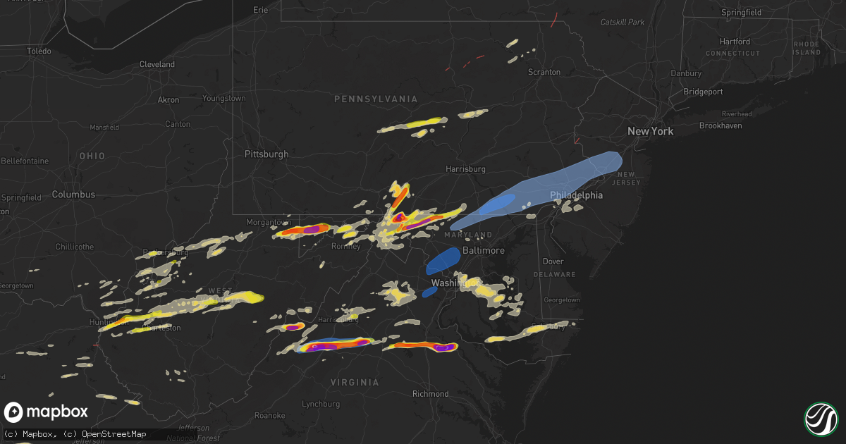
Hail Map on August 7, 2023
Get this storm
August 7 map
$229
one time, instant access
Download today. No call, no setup
Keep the $229
Bought the map and want the full workflow? Apply the entire $229 to a subscription within 7 days. None of it is wasted.
Every map, not just this one
This buys you this map. Subscription and you get every map we run, in the markets you choose from a few cities to whole states to nationwide. Plus real-time alerts the moment a storm fires.
Contact data
Name, contact info, occupancy, even credit band for addresses in the footprint. You go from where it hit to who to call.
Become the source they trust
Unlimited branding weather history reports on demand. You already have the documented answer ready for the property owner, and you are the one who showed up with it.
Property data and RoofTrace estimates
Pull up any address you have got, its value and the exact code rules for that jurisdiction, straight from One Click Code. Then RoofTrace estimates the squares, pitch, and roof value, priced the way you price.
States Impacted by Hail Map on August 7, 2023
Storm reports
South Dakota
| Date | Description |
|---|---|
| 08/07/20236:48 PM CDT | A local report indicates 80 MPH wind near 10 WSW Oglala |
| 08/07/20236:48 PM CDT | A local report indicates 1.00 inch wind near 10 WSW Oglala |
| 08/07/20236:48 PM CDT | Roofs blown off of 2 sheds. |
| 08/07/20236:45 PM CDT | A local report indicates 79 MPH wind near 13 W Oglala |
| 08/07/20236:40 PM CDT | A local report indicates 69 MPH wind near 13 W Oglala |
| 08/07/20236:39 PM CDT | A local report indicates 74 MPH wind near 12 E Oelrichs |
| 08/07/20236:34 PM CDT | A local report indicates 63 MPH wind near 12 E Oelrichs |
Colorado
| Date | Description |
|---|---|
| 08/07/20236:49 PM CDT | Report from mping: quarter |
| 08/07/20236:23 PM CDT | Estimated 2 inch hail reported at location. |
| 08/07/20236:15 PM CDT | Reported via social media. Location and time estimated. |
| 08/07/20235:50 PM CDT | A local report indicates 60 MPH wind near 2 WNW Vernon |
| 08/07/20235:01 PM CDT | A local report indicates 1.25 inch wind near Otis |
| 08/07/20235:00 PM CDT | Delayed report via social media. Hail stripped the corn in a field. Location estimated. |
| 08/07/20233:40 PM CDT | A local report indicates 1.25 inch wind near 1 WNW Stoneham |
Florida
| Date | Description |
|---|---|
| 08/07/20235:47 PM CDT | Fallen trees or limbs resulted in a power outage. |
| 08/07/20235:45 PM CDT | A tree was blown down at 555 east washington st. |
South Carolina
| Date | Description |
|---|---|
| 08/07/20236:59 PM CDT | Tree down blocking both lanes of the 3400 block of williams road. Time estimated based on radar. |
| 08/07/20236:59 PM CDT | Power lines down at the intersection of us-52 and mclaughlin rd. South of florence... Sc. |
| 08/07/20236:46 PM CDT | Tree down on bells hwy blocking both lanes. |
| 08/07/20236:38 PM CDT | Tree down on joe miley rd. |
| 08/07/20236:30 PM CDT | Highway department reported a tree down on old manning road near black river road. Time based on radar. |
| 08/07/20236:26 PM CDT | Highway department reported a tree down on june burn road near the town of manning. Time based on radar. |
| 08/07/20236:25 PM CDT | Chesterfield county dispatch reported trees and power lines down with fire at drucilla church road at old ridge road. |
| 08/07/20236:22 PM CDT | 911 call center reported multiple trees down on highway 52 south and north. Time estimated. |
| 08/07/20236:20 PM CDT | Trees and power lines down off main st. Exact location unknown. |
| 08/07/20236:19 PM CDT | Orangeburg county dispatch reported trees down along fire tower rd. Time estimated based on radar. |
| 08/07/20236:16 PM CDT | Highway department reported a tree down on alcolu street near the town of alcolu. Time based on radar. |
| 08/07/20236:14 PM CDT | Highway department reported a tree down on liberty hill road near the town of summerton. Time based on radar. |
| 08/07/20236:13 PM CDT | A local report indicates 0 MPH wind near 4 SE South Sumter |
| 08/07/20236:13 PM CDT | Highway department reported trees down along boulevard road near mims road. Time based on radar. |
| 08/07/20236:11 PM CDT | Highway department reported trees down along hwy. 521. Time based on radar. |
| 08/07/20236:11 PM CDT | Highway department reported a tree down on panola road. Time based on radar. |
| 08/07/20236:10 PM CDT | Corrects previous tstm wnd dmg report from mcbee. 911 call center reported multiple trees down on powerlines along 8th street in mcbee. Time estimated. |
| 08/07/20236:10 PM CDT | Highway department reported a tree down on ethan stone road near the town of paxville. |
| 08/07/20236:06 PM CDT | Highway department reported trees down along nazarene church road. Time based on radar. |
| 08/07/20236:05 PM CDT | Lexington county em reported trees down along fairview rd. Time estimated based on radar. |
| 08/07/20236:04 PM CDT | Highway department reported a tree down across frank rhames road near the panola community. Time based on radar. |
| 08/07/20236:00 PM CDT | Power line down on great north road. |
| 08/07/20236:00 PM CDT | Chesterfield county dispatch reported trees and power lines down at sandy run creek road and raley road. |
| 08/07/20235:57 PM CDT | Manchester state forest ranger reported a couple of trees down between hwy. 261 and headquarters road. Time based on radar. |
| 08/07/20235:57 PM CDT | Manchester state forest ranger reported a couple of trees down bhighway department reported trees down along boulevard road near mims road. Time based on radar. |
| 08/07/20235:55 PM CDT | Orangeburg county dispatch reported trees down along racetrack road near elloree. Time estimated based on radar. |
| 08/07/20235:55 PM CDT | Em reports power line down and on fire at this location. Time estimated by radar. |
| 08/07/20235:53 PM CDT | Kershaw county dispatch reported trees down at mount pisgah road and jones road. |
| 08/07/20235:53 PM CDT | Corrects previous tstm wnd dmg report from 5 sw jefferson. Kershaw county dispatch reported trees down along mcbee hwy. Time estimated based on radar. |
| 08/07/20235:52 PM CDT | Em reports power line down at this location. Time estimated by radar. |
| 08/07/20235:51 PM CDT | Orangeburg county dispatch reported trees down at the intersection of four holes rd and wild hearts rd. Time estimated based on radar. |
| 08/07/20235:50 PM CDT | Kershaw county dispatch reported widespread trees and powerlines down in the county. Time estimated based on radar. |
| 08/07/20235:45 PM CDT | Tree/power line down with fire arborvine court. |
| 08/07/20235:45 PM CDT | Kershaw county dispatch reported trees down at beaver creek road at john g. Richards road. |
| 08/07/20235:45 PM CDT | Tree on power line sid sites road near kennerly road. |
| 08/07/20235:45 PM CDT | Tree on power line on woodspur road. |
| 08/07/20235:45 PM CDT | Tree on power line on woodspur road. Etween hwy. 261 and headquarters road. Time ba |
| 08/07/20235:44 PM CDT | Em reports tree down and on fire at this location. Time estimated by radar. |
| 08/07/20235:43 PM CDT | Kershaw county dispatch reported trees down along mcbee hwy. Time estimated based on radar. |
| 08/07/20235:43 PM CDT | Em reports tree on power line and on fire at this location. Time provided confirmed by radar. |
| 08/07/20235:40 PM CDT | Kershaw county dispatch reported trees down at the intersection of humphries rd and shivers green rd. Time estimated based on radar. |
| 08/07/20235:40 PM CDT | Em reports tree down on power line at this location. Time estimated by radar. |
| 08/07/20235:35 PM CDT | Lexington county em reported powerlines down along quail valley e south of irmo. Time estimated based on radar. |
| 08/07/20235:33 PM CDT | Em reports tree on power line and on fire at this location. Time provided confirmed by radar and nearby mesonet. |
| 08/07/20235:30 PM CDT | Facebook picture shows a tree down on the side of the road on old brickyard road in irmo. Time estimated by radar. |
| 08/07/20235:30 PM CDT | Calhoun county dispatch reported trees down on sweetwater road at murph mill road. Tree reported down on old state road. |
| 08/07/20235:28 PM CDT | Law enforcement relayed report of trees blocking the road at this location. Time estimated by radar. |
| 08/07/20235:27 PM CDT | Report from mping: 1-inch tree limbs broken; shingles blown off. Em also reports a downed tree in this area. Time estimated by radar. |
| 08/07/20235:27 PM CDT | Newberry county dispatch reports trees down near the intersection of nursery rd and highway 76. Time estimated from radar. |
| 08/07/20235:26 PM CDT | Tree on power line on clear lake road. |
| 08/07/20235:26 PM CDT | Facebook picture shows trees and power lines down at the entrance to rapids subdivision. Time estimated by radar. |
| 08/07/20235:26 PM CDT | Orangeburg county dispatch reported trees down at the intersection of drake dr and fanning rd. Time estimated based on radar. |
| 08/07/20235:25 PM CDT | Nws employee relayed report of a large tree down in the woods near chapin middle school and broad river road. Time estimated by employee. |
| 08/07/20235:25 PM CDT | Local fd reported tree on power line at 4310 camp creek road in lancaster county. |
| 08/07/20235:23 PM CDT | Spotter reported trees down blocking roadway at cartin road at basil road. |
| 08/07/20235:22 PM CDT | Lexington county emergency manager reported powerlines down along bismarck rd north of gaston. Time estimated based on radar. |
| 08/07/20235:20 PM CDT | 911 call center reports numerous trees and powerlines down across fort lawn. |
| 08/07/20235:19 PM CDT | Facebook pictures show the top of a large tree down on property near this location. Time estimated by the person who provided the pictures. |
| 08/07/20235:18 PM CDT | Law enforcement relayed report of trees blocking the road at this location. Time estimated by radar. |
| 08/07/20235:18 PM CDT | Newberry county dispatch reports a tree down on a house near the intersection of park dr and chapman dr. No injuries reported. Time estimated from radar. |
| 08/07/20235:17 PM CDT | Power lines down on columbia highway between ivory key and long road. |
| 08/07/20235:16 PM CDT | Law enforcement relayed report of trees in roadway at this location. Time estimated by radar. |
| 08/07/20235:15 PM CDT | Law enforcement relayed report of trees blocking the road at this location. Time estimated by radar. |
| 08/07/20235:15 PM CDT | 911 call center reports numerous trees and powerlines down across richburg. |
| 08/07/20235:13 PM CDT | Fairfield county em office reported trees down across the county. Time estimated based on radar. |
| 08/07/20235:09 PM CDT | Newberry county dispatch reports trees down in silverstreet on highway 34. Time estimated from radar. |
| 08/07/20235:09 PM CDT | Newberry county dispatch reports trees down near the intersection of wighway 34 and hillbrook ln. Time estimated from radar. |
| 08/07/20235:08 PM CDT | Newberry county dispatch reports trees down near the intersection of beth eden rd and old whitmire hwy. Time estimated from radar. |
| 08/07/20235:08 PM CDT | Newberry county dispatch reports trees down near the intersection of belfast rd and henry longshore rd. Time estimated from radar. |
| 08/07/20235:08 PM CDT | Newberry county dispatch reports trees down on i-26 eastbound near mile marker 73. Time estimated from radar. |
| 08/07/20235:07 PM CDT | Facebook report of damage at the vfw in pelion. Photos confirm a divider wall on the property was destroyed... A flagpole there was bent and at least two trees in the a |
| 08/07/20235:05 PM CDT | Newberry county dispatch reports trees down on macedonia church rd near prosperity. Time estimated from radar. |
| 08/07/20235:04 PM CDT | Social media picture of trees and power lines down in richburg. |
| 08/07/20235:02 PM CDT | Social media picture of a tree down across a fence in rock hill. |
| 08/07/20235:00 PM CDT | Emergency manager reports numerous downed trees and powerlines across all of york county. |
| 08/07/20235:00 PM CDT | 911 call center reports sporadic tree damage across greenwood county. |
| 08/07/20235:00 PM CDT | 911 call center reports numerous trees down across union county. |
| 08/07/20234:56 PM CDT | Newberry county dispatch reports trees down near the intersection of belfast rd and hwy 56. Time estimated from radar. |
| 08/07/20234:55 PM CDT | 911 call center reports trees and powerlines down across all of chester county. |
| 08/07/20234:50 PM CDT | 911 call center reports tree on house near edgefield st. |
| 08/07/20234:50 PM CDT | 911 call center reports tree on roadway near prospect corner rd. |
| 08/07/20234:50 PM CDT | Tree down on roadway on madeline dr and kenbridge ln. |
| 08/07/20234:42 PM CDT | Tree through roof. |
| 08/07/20234:38 PM CDT | Reports of trees down around anderson. |
| 08/07/20234:37 PM CDT | Saluda county dispatch reported trees down on highway 23 near ridge spring. |
| 08/07/20234:35 PM CDT | 911 call center reports trees down on whitmire hwy. |
| 08/07/20234:35 PM CDT | 911 call center reports numerous trees and powerlines down across abbeville county. |
| 08/07/20234:30 PM CDT | 911 call center reports multiple trees down on gowdeysville rd. |
| 08/07/20234:30 PM CDT | Tree on a house and roadway blocked. |
| 08/07/20234:25 PM CDT | 911 call center reports trees down on roadway near goldmine rd. |
| 08/07/20234:25 PM CDT | Tree on power line in laurens. |
| 08/07/20234:24 PM CDT | Tree on warrior creek rd. Time estimated from radar. |
| 08/07/20234:23 PM CDT | 911 call center reports tree on house near craig rd. |
| 08/07/20234:20 PM CDT | 911 call center reports tree on house near w fleming st in ware shoals. |
| 08/07/20234:20 PM CDT | 911 call center reports trees down on roadway near means rd. |
| 08/07/20234:08 PM CDT | Trees down on roadway. |
| 08/07/20234:06 PM CDT | Large tree blocking entire road on hunts bridge road at chapman road. Time estimated from radar. |
| 08/07/20234:06 PM CDT | Power lines down in pacolet. Time estimated from radar. |
| 08/07/20234:00 PM CDT | 911 communications reports multiple trees blocking roadway on farris bridge rd. |
| 08/07/20234:00 PM CDT | A couple of trees down in this area. |
| 08/07/20234:00 PM CDT | Tree on powerline. |
| 08/07/20233:55 PM CDT | Numerous trees down across spartanburg. |
| 08/07/20233:55 PM CDT | Multiple trees down in roebuck. Time estimated from radar. |
| 08/07/20233:55 PM CDT | 911 communications reports trees down on roadway. |
| 08/07/20233:49 PM CDT | Trees on roadway. |
| 08/07/20233:48 PM CDT | Trees down on roadway. |
| 08/07/20233:48 PM CDT | Trees down on roadway. |
| 08/07/20233:46 PM CDT | Trees down in intersection. |
| 08/07/20233:45 PM CDT | Corrects previous tstm wnd dmg report from 4 nnw anderson. Trees down on roadway. |
| 08/07/20233:45 PM CDT | Emergency manager reports large tree on house. |
| 08/07/20233:45 PM CDT | Several fences blown down in the brockman farms neighborhood. |
| 08/07/20233:42 PM CDT | Report of numerous trees down in parkins mill area. Time estimated from radar. |
| 08/07/20233:40 PM CDT | Corrects previous tstm wnd dmg report from 4 nnw anderson. Trees down on roadway. |
| 08/07/20233:36 PM CDT | Corrects previous tstm wnd dmg report from 3 e fountain inn. Trees blocking hunts bridge rd. Also... Tree on power lines on stewart rd. |
| 08/07/20233:36 PM CDT | 3-inch limbs and trees down. |
| 08/07/20233:36 PM CDT | Tree down on powerlines. |
| 08/07/20233:36 PM CDT | Trees blocking bridge. |
| 08/07/20233:36 PM CDT | Tree limbs and power lines down in centerville. Time estimated from radar. |
| 08/07/20233:33 PM CDT | Report of trees down with one on a house. Time estimated from radar. |
| 08/07/20233:30 PM CDT | 911 communications reports numerous trees and powerlines down across oconee county. |
| 08/07/20233:30 PM CDT | 911 communications reports multiple trees down on roadway. |
| 08/07/20233:25 PM CDT | Tree falls on house. |
| 08/07/20233:24 PM CDT | Social media image of large limbs down in yard. |
| 08/07/20233:00 PM CDT | Trees down on roadway. |
| 08/07/20233:00 PM CDT | Trees down on roadway. |
| 08/07/20232:50 PM CDT | 911 call center reports widespread trees and powerlines down across pickens county. |
| 08/06/20238:39 PM CDT | Tree reported down on roadway at francis marion circle. Time estimated based on radar. |
| 08/06/20238:25 PM CDT | Tree reported down from storm outflow boundary. Time estimated based on radar. |
| 08/06/20238:25 PM CDT | Tree reported down on roadway at morgan rd and john meeks way. Time estimated based on radar. |
| 08/06/20238:25 PM CDT | Tree reported down on parris island gateway from thunderstorm outflow. Time estimated based on radar. |
| 08/06/20238:07 PM CDT | Emergency manager reported multiple trees down along the 3000 block of wiggins road. Trees blocked the road in several locations. Time was estimated via radar data. |
| 08/06/20238:07 PM CDT | Emergency manager reported a tree down along the 3000 block of wiggins rd. Time was estimated via radar data. |
| 08/06/20238:02 PM CDT | Trees down in the backyard of a residence in the bridgewater community off of sc-90. Time provided by reporter. |
| 08/06/20238:02 PM CDT | Tree down in the backyard of a residence in the bridgewater community off of sc-90. Time provided by reporter. |
| 08/06/20237:56 PM CDT | Tree down along wood road blocking one lane. A backhoe was needed to remove the tree. Time estimated based on radar. |
| 08/06/20237:54 PM CDT | Fence partially blown down and minor damage to a couple homes on country pine drive east of us-501 northwest of myrtle beach... Sc. Time provided by reporter. |
| 08/06/20237:53 PM CDT | Tree down at 11500 green pond hwy. |
| 08/06/20237:41 PM CDT | Colleton county emergency management reported a tree and power lines down near 3000 ritter road. The tree was blocking one lane of the road. |
| 08/06/20237:36 PM CDT | Tree down blocking both lanes at 3726 hendersonville hwy. |
| 08/06/20237:36 PM CDT | Tree down on black creek rd blocking both lanes. |
| 08/06/20237:33 PM CDT | Tree down on hendersonville hwy blocking one lane. |
| 08/06/20237:18 PM CDT | Power lines down in the town of gresham... Sc. Time estimated based on radar. |
| 08/06/20237:17 PM CDT | Power lines down in the town of marion... Sc. Time estimated based on radar. |
| 08/06/20237:11 PM CDT | Tree down blocking one lane of the 5200 block of hudson mill road near ruffin. Time estimated based on radar. |
| 08/06/20237:11 PM CDT | Tree down blocking both lanes of sniders hwy. |
| 08/06/20237:10 PM CDT | Tree down on scuffletown rd blocking both lanes. |
| 08/06/20237:04 PM CDT | Tree down blocking one lane of bells hwy. |
Delaware
| Date | Description |
|---|---|
| 08/07/20235:26 PM CDT | Report of tree down in north wilmington on social media. Time estimated via radar. |
| 08/07/20235:20 PM CDT | Picture of an uprooted tree at the corner of linden and franklin st. Time estimated from radar. |
| 08/07/20235:20 PM CDT | Path of significant tree damage reported between yorktowne and highland meadows neighborhoods. Some minor siding damage to houses. Photos via social media. |
| 08/07/20235:14 PM CDT | Public report of large tree down in backyard on social media. Photo provided. Time estimated via radar. |
| 08/07/20235:14 PM CDT | Report of multiple trees down across meetinghouse and benge roads in hockessin. Time estimated via radar. |
| 08/07/20235:14 PM CDT | Report of multiple trees down with power outages in brookside on social media. Time estimated via radar. |
| 08/07/20235:12 PM CDT | Tree and wire damage along mill creek road. Time estimated from radar. |
| 08/07/20235:10 PM CDT | A structure collapsed. |
| 08/07/20235:08 PM CDT | Report of trees down in newark... De near the de/md border. Time estimated from radar. |
District of Columbia
| Date | Description |
|---|---|
| 08/07/20234:54 PM CDT | Large tree down on the southwest lawn of the us capitol. Numerous tree branches down on the lawn. |
| 08/07/20234:47 PM CDT | Tree down on a vehicle on canal street nw. |
Nebraska
| Date | Description |
|---|---|
| 08/07/20236:29 PM CDT | Peas... Quarters and some slightly larger hail. |
| 08/07/20236:00 PM CDT | Public reports golf ball hail that was oblong... At the time hail had occurred for over 10 or more minutes. |
| 08/07/20235:55 PM CDT | Public reports heavy rain with penny to quarter sized hail... Time estimated by radar. |
| 08/07/20235:53 PM CDT | Ping pong ball size hail in indianola at 4:53 pm mdt. |
| 08/07/20235:50 PM CDT | Public reports golf ball or smaller sized hail... Ground white with hail and very heavy rainfall... Over 1.5 inches in the matter of 30 to 40 mins... Time of hail estim |
| 08/07/20235:50 PM CDT | Corrects previous hail report from ashby. Trained spotter reports golf ball or smaller sized hail... Ground white with hail and very heavy rainfall... Over 1.5 inches i |
| 08/07/20235:43 PM CDT | Period of golfball to hen egg size hail reported. Hail lasted approx 20 minutes... Reported via facebook. Time estimated from radar. |
| 08/07/20235:30 PM CDT | Public estimates golf ball sized hail nearly the entire ground being covered. |
| 08/07/20235:29 PM CDT | Public reports ping pong sized hail with hail covering the ground. |
| 08/07/20234:35 PM CDT | Reported via social media. Dime to quarter sized hail. Time estimated via radar. |
| 08/07/20234:15 PM CDT | Delayed report of golf ball to baseball sized hail a the junc |
| 08/07/20234:15 PM CDT | Delayed report of golf ball to baseball sized hail a the junction of highways 6 and 25. |
| 08/07/20233:50 PM CDT | Spotter measured up to ping pong ball sized hail. Most of the hail was quarter in size. |
| 08/07/20233:50 PM CDT | Quarter sized hail observed in a field. |
| 08/07/20233:50 PM CDT | Quarter sized hail observed in a field. |
| 08/07/20233:30 PM CDT | Reported via social media. |
| 08/06/20238:52 PM CDT | Was out during the storm. Arrived back to see quarter size hail still on the ground. Time from radar. |
| 08/06/20238:44 PM CDT | Delayed report from a pws mesonet site north of town. |
| 08/06/20238:30 PM CDT | 60+ mph thunderstorm wind gusts. |
| 08/06/20238:30 PM CDT | 60+ mph thunderstorm wind gusts. |
| 08/06/20238:09 PM CDT | Public reports brief quarter sized hail... Time estimated by radar. |
| 08/06/20238:04 PM CDT | Public reports quarter to half dollar sized hail... Time estimate based on radar. |
| 08/06/20238:01 PM CDT | Public reports brief spurt of quarter sized hail with heavy rainfall. |
| 08/06/20237:42 PM CDT | Corrects previous hail report from 4 ene whitney. Picture from social media showing golf ball size hail. |
| 08/06/20237:42 PM CDT | Picture from social media showing golf ball size hail. |
| 08/06/20237:41 PM CDT | Corrects previous hail report from 8 nne hay springs. Public reports brief spurt of quarter sized hail with heavy rainfall. |
| 08/06/20237:35 PM CDT | Trained spotter reports slightly larger than golf ball size hail. |
| 08/06/20237:02 PM CDT | Update to previous tstm wnd dmg report from 10 s culbertson. Report and pictures of roof blown off home approximately 10 miles south of culbertson. Barn door also torn |
| 08/06/20237:02 PM CDT | Report and pictures of roof blown off home approximately 10 miles south of culbertson. Received via facebook. |
| 08/06/20237:00 PM CDT | Quarter inch hail and pea sized hail; 0.50 inches of precip. |
Virginia
| Date | Description |
|---|---|
| 08/07/20236:20 PM CDT | A local report indicates 2.75 inch wind near 3 NW Supply |
| 08/07/20236:05 PM CDT | Corrects previous hail report from 1 ssw fort a.p. Hill. Time estimated from radar. Hail stone was measured approximately 15 minutes after the hail core passed over thi |
| 08/07/20236:05 PM CDT | Time estimated from radar. Hail stone was measured approximately 15 minutes after the hail core passed over this location. |
| 08/07/20235:40 PM CDT | Corrects previous hail report from 1 nnw fort a.p. Hill. Golf ball sized hail reported near fort ap hill. |
| 08/07/20235:37 PM CDT | Numerous trees down along highway 311 between white sulphur springs wv and crows va. |
| 08/07/20235:10 PM CDT | Golf ball sized hail report |
| 08/07/20235:10 PM CDT | Golf ball sized hail reported near fort ap hill. |
| 08/07/20235:07 PM CDT | Trained spotter reports golf ball sized hail near lake anna state park. Time estimated from radar. |
| 08/07/20234:51 PM CDT | Multiple trees down in coal landing. |
| 08/07/20234:48 PM CDT | Trees down on monrovia road near shady grove lane. Wires down as well. |
| 08/07/20234:38 PM CDT | Tree down at intersection of forum dr and gov't center pkwy |
| 08/07/20234:36 PM CDT | Large tree down onto chase commons court. |
| 08/07/20234:35 PM CDT | Corrects previous tstm wnd dmg report from 4 nne waldrop. One tree and several large tree limbs downed along us-15 between waldrop and gordonsville. |
| 08/07/20234:33 PM CDT | Multiple roads closed due to downed trees between somerville and bristersburg. |
| 08/07/20234:33 PM CDT | Tree down in nokesville. |
| 08/07/20234:32 PM CDT | Tree down on judicial drive near yorktown court. |
| 08/07/20234:32 PM CDT | Tree down near the intersection of kettle club road and north james madison highway |
| 08/07/20234:30 PM CDT | Tree down in 11500 block of valley road. |
| 08/07/20234:29 PM CDT | Tree down onto parked car on south penderbrook drive at the intersection with iverness road. |
| 08/07/20234:28 PM CDT | Considerable tree damage on quiet brook road. Numerous trees uprooted. At least a dozen pine trees snapped in half. |
| 08/07/20234:24 PM CDT | 51kt measured at manassas arpt |
| 08/07/20234:20 PM CDT | A large tree was blown down by thunderstorm winds near the intersection of highway 58 and soapstone road. |
| 08/07/20234:19 PM CDT | A tree was blown down onto a home along old well road by thunderstorm winds... Trapping a resident inside the home. |
| 08/07/20234:19 PM CDT | Multiple large tree branches down on the 7500 block of alleghany road. |
| 08/07/20234:18 PM CDT | Several trees down along lesters fork road. Time estimated from radar. |
| 08/07/20234:17 PM CDT | Tree down along hazel river road |
| 08/07/20234:17 PM CDT | A large tree was blown down across a power line along marigold road by thunderstorm winds. Power is out in the local area. |
| 08/07/20234:16 PM CDT | Multiple trees were blown down along penn store road by thunderstorm winds. |
| 08/07/20234:14 PM CDT | Wind gust of 50 knots measured at nova loudon cmapus sterling. |
| 08/07/20234:12 PM CDT | Thunderstorm winds blew a tree down along route 58... Approximately four miles west of spencer. Report in twitter. |
| 08/07/20234:10 PM CDT | Golf ball sized hail observed near earlysville. |
| 08/07/20234:09 PM CDT | A couple trees down on furnace mountain road. |
| 08/07/20234:08 PM CDT | A local report indicates 1.75 inch wind near 3 N Earlysville |
| 08/07/20234:05 PM CDT | One tree and several large tree limbs downed along us-15 between waldrop and gordonsville. |
| 08/07/20234:04 PM CDT | Multiple trees... Power lines... And branches down in earlysville. Several roads closed. |
| 08/07/20234:04 PM CDT | At least 6 trees down within a block of an nws employees home in ashburn. |
| 08/07/20234:02 PM CDT | Tops of trees blown off and 1 tree uprooted. |
| 08/07/20234:02 PM CDT | A local report indicates 2.50 inch wind near Earlysville |
| 08/07/20233:59 PM CDT | Over a dozen trees down between warrenton and old tavern. Several wires and poles down as well. |
| 08/07/20233:54 PM CDT | Multiple trees were blown down across the southern end of the community of stuart by thunderstorm winds. |
| 08/07/20233:52 PM CDT | Multiple trees down on enon school road. |
| 08/07/20233:49 PM CDT | Tree down near the intersection of 7 ponds road and view town road |
| 08/07/20233:49 PM CDT | Tree down along quail ridge drive |
| 08/07/20233:48 PM CDT | Trees down on rixleyville road. Wires also down in a couple locations. |
| 08/07/20233:48 PM CDT | A couple trees down on waterford road. |
| 08/07/20233:47 PM CDT | Multiple trees down in far northeastern fauquier county around halfway road... The plains road... Rock hill mill road... And adjoining roads. |
| 08/07/20233:46 PM CDT | Tree down near the intersection of garth road and yule farm |
| 08/07/20233:44 PM CDT | Tree down on powerlines near the intersection of dodson road and starwood drive |
| 08/07/20233:44 PM CDT | Tree down near the intersection of view town road and barn view lane |
| 08/07/20233:41 PM CDT | Tree down near the intersection of richmond road and campground lane |
| 08/07/20233:39 PM CDT | Multiple trees down in the upperville. Several wires down as well. |
| 08/07/20233:38 PM CDT | Multiple trees were blown down in the community of claudville by thunderstorm winds. |
| 08/07/20233:37 PM CDT | Tree down near the intersection of sperryville pike and yancy road |
| 08/07/20233:29 PM CDT | Several trees down in loudoun heights. |
| 08/07/20233:29 PM CDT | A local report indicates 2.00 inch wind near 2 NW Waynesboro |
| 08/07/20233:29 PM CDT | Media relayed report of quarter sized hail on grindstone mountain road in comertown... Va. Time estimated from radar. |
| 08/07/20233:26 PM CDT | Over a dozen trees down on leeds manor road and nearby roads just south of i-66. |
| 08/07/20233:26 PM CDT | Multiple calls for downed trees and wires in berryville. |
| 08/07/20233:25 PM CDT | A local report indicates 1.50 inch wind near 4 SW Hermitage |
| 08/07/20233:23 PM CDT | Numerous trees down along weakley hollow road |
| 08/07/20233:22 PM CDT | A local report indicates 2.50 inch wind near 2 S Staunton |
| 08/07/20233:19 PM CDT | Multiple trees down along fodderstack road |
| 08/07/20233:16 PM CDT | Three trees down near the 4000 block of remount road |
| 08/07/20233:15 PM CDT | Golf ball sized hail measured near staunton. |
| 08/07/20233:15 PM CDT | A local report indicates 2.00 inch wind near 2 S Staunton |
| 08/07/20233:15 PM CDT | Numerous trees down in shenandoah. |
| 08/07/20233:14 PM CDT | Tree down on the 400 block of blainesville road |
| 08/07/20233:09 PM CDT | A local report indicates 3.00 inch wind near Trimbles Mill |
| 08/07/20233:08 PM CDT | Tree down on the 1100 block of ridge view lane |
| 08/07/20233:08 PM CDT | Tree down near the intersection of crooked run road and comertown road |
| 08/07/20233:05 PM CDT | Tree down on the 400 block of 3rd street |
| 08/07/20233:04 PM CDT | Numerous trees down near battle creek road and north view drive. |
| 08/07/20233:03 PM CDT | Multiple reports of downed trees in gainesboro. |
| 08/07/20233:03 PM CDT | Tree down on the 400 block of grove hill river road |
| 08/07/20233:03 PM CDT | Tree down along 10th street |
| 08/07/20233:02 PM CDT | A couple calls for downed trees and wires in cross junction. |
| 08/07/20233:01 PM CDT | Trees down on wardensville grade road... Singhass road... Dicks hollow road... And us-50. |
| 08/07/20233:00 PM CDT | Trees down on indian hollow road. Road closed. |
| 08/07/20232:53 PM CDT | Tree down near the 100 block of dogwood drive |
| 08/07/20232:51 PM CDT | Tree down on powerlines near the 200 block of aspen trail |
| 08/07/20232:48 PM CDT | Tree down near the intersection of south page valley road and egypt bend road |
| 08/07/20232:48 PM CDT | Multiple trees down in craigsville per whsv. Photos provided. |
| 08/07/20232:45 PM CDT | Multiple trees down in new market per whsv. Photos provided. |
| 08/07/20232:39 PM CDT | Tree down on the 400 block of south main street |
| 08/07/20232:37 PM CDT | Multiple trees down in broadway per whsv. Photos provided. |
| 08/07/20232:37 PM CDT | Metal roof blown off a barn in broadway. |
| 08/07/20232:35 PM CDT | Tree down on powerlines near the 300 block of cross junction road |
| 08/07/20232:33 PM CDT | Tree down on the 400 block of west springbrook road |
| 08/07/20232:25 PM CDT | A local report indicates 1.00 inch wind near 1 N Willis |
| 08/07/20232:23 PM CDT | Quarter to half-dollar sized hail was observed at the intersection of highway 221 and indian valley road. |
| 08/07/20232:16 PM CDT | Tree down on powerlines near the intersection of bare ridge road and hopkins gap road |
| 08/07/20232:15 PM CDT | Multiple reports of trees down across county. Reported tree down across roadway off of whites mill road. |
| 08/07/20231:55 PM CDT | Wdbj photo relayed of tennis ball sized hail. |
| 08/07/20231:47 PM CDT | Whsv photo of two inch hail. |
| 08/07/20231:39 PM CDT | Multiple trees down on mill gap road in mill gap. Road closed for several hours. |
| 08/07/20231:37 PM CDT | Considerable tree damage on blue grass valley road and laurel fork road. |
| 08/07/202312:50 PM CDT | Several trees downed in the chilhowie area. |
| 08/06/20238:01 PM CDT | Multiple reports of downed trees near gore toward the west virginia state line. |
New Jersey
| Date | Description |
|---|---|
| 08/07/20236:40 PM CDT | Emergency manager reports extensive tree damage in holland twp near bloomsbury. Time estimated via radar. |
| 08/07/20236:37 PM CDT | Us206 closed between province line road and quaker road due to downed trees and wires. Time estimated from radar. |
| 08/07/20236:29 PM CDT | Downed wires in bordentown on us130 between us206 and woodland avenue. Time estimated from radar. |
| 08/07/20236:14 PM CDT | Downed utlity pole in medford on route 70 near hartford road. Time estimated from radar. |
| 08/07/20236:09 PM CDT | Report of wires down on stark lane near delran... Nj. Time estimated via radar. |
| 08/07/20236:08 PM CDT | Large tree limb down. Time estimated via radar. |
| 08/07/20236:01 PM CDT | Trees and wires down on east maple avenue and golfview road. Time estimated from radar. |
| 08/07/20236:00 PM CDT | Tree down blocking roadway on north stanwick road in moorestown. Time estimated from radar. |
| 08/07/20235:46 PM CDT | Emergency management reports trees down in mickleton... Nj. Time estimated via radar. |
West Virginia
| Date | Description |
|---|---|
| 08/07/20235:28 PM CDT | Corrects previous tstm wnd dmg report from 2 wnw gap mills. Multiple trees were blown down by thunderstorm winds along doss shaver road. |
| 08/07/20235:23 PM CDT | Multiple trees were blown down by thunderstorm winds along doss shaver road. |
| 08/07/20235:21 PM CDT | A few trees were blown down by thunderstorm winds in the hillsdale area. |
| 08/07/20235:21 PM CDT | A 75 foot tree was blown down... Landing on an 8 by 10 trailer... Carport and vehicle. Time estimated from radar. |
| 08/07/20235:11 PM CDT | Few trees downed by thunderstorm winds near monroe/summers county line in western monroe county. |
| 08/07/20235:10 PM CDT | A large tree fell across davis street in alderson... Partially landing on a house. |
| 08/07/20235:03 PM CDT | Thunderstorm winds blew at least ten trees down at residence of spotter. |
| 08/07/20235:02 PM CDT | Thunderstorm winds blew one wrist-size branch and other smaller branches down. |
| 08/07/20235:00 PM CDT | Multiple trees were blown down by thunderstorm winds near the intersection of highway 3 and highway 12. |
| 08/07/20234:56 PM CDT | Trees and limbs down. Powerline snapped on beech run road near hinton. |
| 08/07/20234:55 PM CDT | Multiple trees were blown down in the community of bellepoint by thunderstorm winds. |
| 08/07/20234:50 PM CDT | Multiple trees were blown down in the community of jumping branch by thunderstorm winds. Some of the trees were blown down along highway 3. |
| 08/07/20234:42 PM CDT | Tree down on lines. Time estimated from radar. |
| 08/07/20234:36 PM CDT | Tree down along power lines. Power out in the area. |
| 08/07/20234:36 PM CDT | Tree limb fell and knocked a power line down across the roadway. Power pole is slanted... And another pole is on the ground. Time estimated from radar. |
| 08/07/20234:36 PM CDT | Tree across saye lane. Power lines are down. Time estimated from radar. |
| 08/07/20234:33 PM CDT | Numerous trees down on all roads exiting franklin. |
| 08/07/20234:21 PM CDT | Tree down in the roadway. |
| 08/07/20233:45 PM CDT | Tree reported down near the town of cleveland. |
| 08/07/20233:30 PM CDT | Power pole fell along steward street in bim. |
| 08/07/20233:16 PM CDT | Tree down. |
| 08/07/20233:07 PM CDT | Power lines reported down on the 600 block of gosling marsh road. |
| 08/07/20233:04 PM CDT | Powers line reported down on the 800 block of froniier drive. |
| 08/07/20233:03 PM CDT | Tree and power lines reported down on runnymeade road near torytown road. |
| 08/07/20233:01 PM CDT | Power lines reported down on the 2600 block of goldmiller road. |
| 08/07/20233:01 PM CDT | Power lines reported down on virginia ave near bowers street. |
| 08/07/20233:00 PM CDT | Tree reported down on the 200 block of centre street. |
| 08/07/20232:58 PM CDT | Power outage caused by tree damage reported by utility company. |
| 08/07/20232:58 PM CDT | Tree reported down. |
| 08/07/20232:58 PM CDT | Tree reported down on the 600 block of s queen streat. |
| 08/07/20232:52 PM CDT | Tree reported down. |
| 08/07/20232:51 PM CDT | Tree reported down. |
| 08/07/20232:50 PM CDT | Power lines down in the roadway along 7th avenue in charleston. |
| 08/07/20232:49 PM CDT | Tree reported down on the 600 block of back creek valley road. |
| 08/07/20232:48 PM CDT | Tree down along falls road near capon bridge |
| 08/07/20232:44 PM CDT | 2 power lines touching and trees across hinkle ridge road. |
| 08/07/20232:43 PM CDT | Dozens of trees down in delray. Multiple wires down and power poles down as well. |
| 08/07/20232:42 PM CDT | Photos sent of tree damage. |
| 08/07/20232:40 PM CDT | Tree down reported. |
| 08/07/20232:35 PM CDT | Multiple trees down from lost creek to salem. |
| 08/07/20232:35 PM CDT | Utility company reports power outages caused by tree damage along buck fork road. |
| 08/07/20232:25 PM CDT | Tree down along reynolds gap road |
| 08/07/20232:20 PM CDT | Report received via social media picture. |
| 08/07/20232:19 PM CDT | Trees down across from welton park. |
| 08/07/20232:15 PM CDT | Wind gust of 53 knots measured at petersburg airport. |
| 08/07/20232:15 PM CDT | Multiple trees down on fort gay road. |
| 08/07/20232:11 PM CDT | A couple trees down in elk garden. |
| 08/07/20232:06 PM CDT | A couple trees down on different parts of welton orchard road near the grant and hardy county lines. |
| 08/07/20232:00 PM CDT | Utility company reports power outages due to tree damage. |
| 08/07/20231:55 PM CDT | Report received via social media picture. |
| 08/07/20231:54 PM CDT | Tree reported down. |
| 08/07/20231:53 PM CDT | Tree down 3 miles south of franklin. |
| 08/07/20231:50 PM CDT | Numerous trees down in franklin. |
| 08/07/20231:50 PM CDT | Tree down on alison road. |
| 08/07/20231:49 PM CDT | Tree reported down on the 1000 block of jacobs road. |
| 08/07/20231:48 PM CDT | Multiple trees down in harman. |
| 08/07/20231:47 PM CDT | Public reports hail up to quarter size near fort ashby. Time estimated from radar. |
| 08/07/20231:45 PM CDT | Several public reports of quarter to dollar sized hail in falling waters... Wv. Time estimated from radar. |
| 08/07/20231:43 PM CDT | Trees down north of north fork highway in cabins resulting in closed roads. |
| 08/07/20231:40 PM CDT | Tree down on dewitt road. |
| 08/07/20231:39 PM CDT | Tree down. |
| 08/07/20231:39 PM CDT | Tree down along cumberland road near springfield |
| 08/07/20231:39 PM CDT | County em reporting multiple trees and wires down in the harper area. |
| 08/07/20231:37 PM CDT | A local report indicates 1.00 inch wind near 2 S Bancroft |
| 08/07/20231:37 PM CDT | A local report indicates 1.00 inch wind near 2 S Bancroft |
| 08/07/20231:36 PM CDT | Tree down on power line on manilla creek road. |
| 08/07/20231:35 PM CDT | Tree reported down near the intersection of tuscarora pike and delmar orchard road. |
| 08/07/20231:35 PM CDT | Trees down in roadway in the area |
| 08/07/20231:34 PM CDT | A couple trees and lines down in fort ashby. |
| 08/07/20231:27 PM CDT | Multiple roads closed in short gap due to downed trees and power lines. |
| 08/07/20231:24 PM CDT | Trees down in area of valley bend. |
| 08/07/20231:23 PM CDT | A local report indicates 1.00 inch wind near 1 S Johnsontown |
| 08/07/20231:21 PM CDT | Tree down across point pleasant road. |
| 08/07/20231:20 PM CDT | Tree down. |
| 08/07/20231:19 PM CDT | Tree reported down on vehicle. Power lines down as well. |
| 08/07/20231:15 PM CDT | Trees reported down along sr 219. Time estimated from radar. |
| 08/07/20231:12 PM CDT | Tree down on gladesville road. Public report remarks time of event. |
| 08/07/20231:08 PM CDT | A local report indicates 1.50 inch wind near 4 ENE Barboursville |
| 08/07/20231:06 PM CDT | Tree down along union road. Time estimated from radar. |
| 08/07/20231:06 PM CDT | A local report indicates 1.25 inch wind near 1 NNW Barboursville |
| 08/07/20231:05 PM CDT | Doh reports quarter sized hail. |
| 08/07/20231:00 PM CDT | Trained spotter reported 1.5 inch hail. |
| 08/07/202312:59 PM CDT | Trees reported down blocking shelbyville road. |
| 08/07/202312:55 PM CDT | Tree down near intersection of alexander rd. And reger run rd. |
| 08/07/202312:54 PM CDT | Photos show snapped and uprooted trees in the area. Time estimated based on radar. |
| 08/07/202312:50 PM CDT | Numerous trees down on all roads exiting franklin. |
| 08/07/202312:47 PM CDT | Power line down. |
| 08/07/202312:45 PM CDT | Trees down blocking both directions of bens run road. |
| 08/07/202312:40 PM CDT | Several trees down with biggest concentration around centerville area. |
| 08/07/202312:36 PM CDT | Trees reported down on chapel rd. |
| 08/07/202312:30 PM CDT | Hail reported on scott cramer road. |
| 08/07/202312:25 PM CDT | A local report indicates 1.75 inch wind near Lenox |
| 08/07/202312:24 PM CDT | Broken windows along dixon drive due to hail. Vegetation was significantly impacted. |
| 08/07/202312:24 PM CDT | A local report indicates 1.75 inch wind near 2 S Lenox |
| 08/07/202312:24 PM CDT | Corn crop damaged significantly by hail of at least golf ball size. |
| 08/07/202312:24 PM CDT | Pictures provided. |
| 08/07/202312:23 PM CDT | Tree reported down. |
| 08/07/202312:23 PM CDT | Windows and vehicles damged by hail along coal lick road. Pictures provided. |
| 08/07/202312:23 PM CDT | At least 2 inch hail along coal lick road. Video provided. |
| 08/07/202312:22 PM CDT | Pictures provided. |
| 08/07/202312:22 PM CDT | 1 inch hail observed in gassaway. |
| 08/07/202312:22 PM CDT | Tree down obstructing roadway. |
| 08/07/202312:20 PM CDT | Photo of quarter size hail. |
| 08/07/202312:20 PM CDT | Multiple trees down. |
| 08/07/202312:18 PM CDT | Trees down |
| 08/07/202312:18 PM CDT | Photos show downed trees that also caused minor roof damage to home near kingwood. Time estimated based on radar. |
| 08/07/202312:18 PM CDT | A local report indicates 1.50 inch wind near Albright |
| 08/07/202312:17 PM CDT | Tree down obstructing roadway. |
| 08/07/202312:15 PM CDT | A local report indicates 1.00 inch wind near 3 W Kingwood |
| 08/07/202312:15 PM CDT | Tree down obstructing roadway. |
| 08/07/202312:11 PM CDT | Multiple trees down |
| 08/07/202312:11 PM CDT | Trees down on gladesville road |
| 08/07/202312:10 PM CDT | Multiple trees down |
| 08/07/202312:10 PM CDT | A local report indicates 1.00 inch wind near 1 NNE Smith Crossroads |
| 08/07/202312:09 PM CDT | Trees down |
| 08/07/202312:07 PM CDT | Tree fell and hit power lines on dogtown road. |
| 08/07/202312:07 PM CDT | Tree and power lines donw on q road and m road. |
| 08/07/202312:02 PM CDT | Trees down |
| 08/07/202311:48 AM CDT | Several trees down |
| 08/07/202311:47 AM CDT | Several trees down |
| 08/07/202311:46 AM CDT | Trees down on fairmont rd |
| 08/07/202311:45 AM CDT | Tree down on vineyard ridge road. |
| 08/07/202311:42 AM CDT | Trees down and power out. |
| 08/07/202311:35 AM CDT | Tree down on barrcut road. |
| 08/07/202311:17 AM CDT | Tree down. |
| 08/07/202310:40 AM CDT | Tree on power lines. |
| 08/07/202310:15 AM CDT | Multiple trees and downed power lines reported in the vienna area. |
Alabama
| Date | Description |
|---|---|
| 08/07/20234:13 PM CDT | Trees down in the area of county road 82 and highway 431. Winds estimated to be sub-severe. |
| 08/07/20234:04 PM CDT | Reports of trees down in the abernathy area near the state line. Time estimated via radar. |
| 08/07/20234:00 PM CDT | Tree on structure. Time estimated from radar. |
| 08/07/20233:57 PM CDT | Several trees down in the piney woods area. |
| 08/07/20233:55 PM CDT | Multiple trees and power lines down in oxford. |
| 08/07/20233:53 PM CDT | Several reports of trees and power lines down in heflin. |
| 08/07/20233:50 PM CDT | Multiple trees and powerlines down across anniston. |
| 08/07/20233:50 PM CDT | Tree on house on highway 68 near sand rock. Time estimated via radar. |
| 08/07/20233:40 PM CDT | A tree was knocked down onto a house and car on cr 104. Time estimated by radar. |
| 08/07/20233:38 PM CDT | Tree in roadway on highway 411 at county road 18. |
| 08/07/20233:38 PM CDT | Multiple trees and power lines down in the piedmont area. |
| 08/07/20233:30 PM CDT | Multiple trees and power lines down in the jacksonville area. |
| 08/07/20233:19 PM CDT | Social media report of numerous trees down at a residence in cropwell. |
| 08/07/20233:18 PM CDT | Trees were knocked down across the road at cr 34 at cr 9. Time estimated by radar. |
| 08/07/20233:15 PM CDT | Trees were knocked down at highway 68 at cr 24. Time estimated by radar. |
| 08/07/20233:14 PM CDT | Reports of trees in roadways on the north side of pell city. Time estimated via radar. |
| 08/07/20233:12 PM CDT | Structural damage and roof was blown off of a mobile home on the 300 block of cr 124. Time estimated by radar. |
| 08/07/20233:08 PM CDT | Several reports of trees and power lines down in the springville area. Time estimated via radar. |
| 08/07/20233:08 PM CDT | Trees knocked down blocking road at bakers chapel and mcdonald road. |
| 08/07/20233:08 PM CDT | A tree was knocked down on the road alabama highway 68 at arley lacey road. Time estimated by radar. |
| 08/07/20233:08 PM CDT | Tree on highway 411 at slackland. |
| 08/07/20233:08 PM CDT | Large tree down at mt. Olive first baptist. |
| 08/07/20233:08 PM CDT | Trees were knocked down on the bridge along hustleville road. Time estimated by radar. |
| 08/07/20233:06 PM CDT | Trees and power lines down in the steele area. Time estimated via radar. |
| 08/07/20233:06 PM CDT | Multiple trees were knocked down on the road at 753 davis road. Time estimated by radar. |
| 08/07/20233:06 PM CDT | Trees and power lines down around ashville. |
| 08/07/20233:04 PM CDT | A tree was knocked down on the road at 662 kykendall road. Time estimated by radar. |
| 08/07/20233:02 PM CDT | Trees were knocked down into the roadway along baltimore avenue. Time estimated by radar. |
| 08/07/20233:02 PM CDT | A tree was knocked down on the road at martling road and wright road. Time estimated by radar. |
| 08/07/20233:02 PM CDT | Trees and powerlines were knocked down on wyeth lane. Time estimated by radar. |
| 08/07/20233:02 PM CDT | A tree was knocked down onto red barn road and highway 205. Time estimated by radar. |
| 08/07/20233:01 PM CDT | Tree down on holliday drive in the highland lake area. |
| 08/07/20232:59 PM CDT | Trees and power lines down on multiple roads in the sardis city area. |
| 08/07/20232:57 PM CDT | Trees were knocked down with total blockage at 4570 pleasant hill road. Time estimated by radar. |
| 08/07/20232:55 PM CDT | A tree was knocked down on the road at pleasant grove road and kelley drive. Time estimated by radar. |
| 08/07/20232:55 PM CDT | Trees and powerlines were knocked down at frygap mountain road and warrenton road. Time estimated by radar. |
| 08/07/20232:55 PM CDT | Trees were knocked down across the road along askia road. Time estimated by radar. |
| 08/07/20232:55 PM CDT | Several trees down on roadways in the gaylesville and broomtown areas. Time estimated via radar. |
| 08/07/20232:53 PM CDT | Trees were knocked down onto the road along thompson falls road. Time estimated by radar. |
| 08/07/20232:53 PM CDT | A tree was knocked down on the road at 4570 pleasant hill road.time estimated by radar. |
| 08/07/20232:51 PM CDT | Tree down on greens chapel rd. Time estimated via radar. |
| 08/07/20232:50 PM CDT | Tree down on power lines on old walker rd. |
| 08/07/20232:47 PM CDT | A social media report/photo of a tree damaging a vehicle off of highway 231 in south arab. Time estimated by radar. |
| 08/07/20232:46 PM CDT | Tree down on miller rd near snead. |
| 08/07/20232:46 PM CDT | Tree down on high rock rd. Time estimated via radar. |
| 08/07/20232:38 PM CDT | Trees were knocked down at 1425 cr 110. Time estimated by radar. |
| 08/07/20232:36 PM CDT | Trees were knocked down at 3820 cr 509. Time estimated by radar. |
| 08/07/20232:36 PM CDT | Trees were knocked down at 5688 cr 1435. Time estimated by radar. |
| 08/07/20232:36 PM CDT | Trees down on highway 69 between jasper and cullman county line. Time estimated. |
| 08/07/20232:35 PM CDT | Tree down on county highway 1. |
| 08/07/20232:30 PM CDT | Around 11500 without power due to outages from the thunderstorms. |
| 08/07/20232:30 PM CDT | Large trees uprooted at highway 157 at st. Joseph drive. Time estimated by radar. |
| 08/07/20232:30 PM CDT | Windows were blown out in the public library... With damage to shelves and books inside. Time estimated by radar. |
| 08/07/20232:30 PM CDT | Trees were knocked down at 112 veterans drive. Time estimated by radar. |
| 08/07/20232:29 PM CDT | Several trees down on glennwood rd near morris. |
| 08/07/20232:27 PM CDT | Trees were knocked down at 1030 u.s. Highway 278 west. Time estimated by radar. |
| 08/07/20232:27 PM CDT | Trees were knocked down at 437 day gap road. Time estimated by radar. |
| 08/07/20232:27 PM CDT | Trees and a barn were knocked down at new cut road at rb orr road. Time estimated by radar. |
| 08/07/20232:12 PM CDT | Numerous trees down in the addison and arley areas. Time estimated via radar. |
| 08/07/20231:52 PM CDT | Reports of trees down around the ashridge community. |
| 08/07/20231:40 PM CDT | Trees down on cornwall ave and highway 273 in cedar bluff. |
| 08/07/20231:14 PM CDT | A tree was knocked down on posey loop at highway 247. Time estimated by radar. |
| 08/07/20231:12 PM CDT | Tree down on power lines in the sardis area. Winds estimated to be sub-severe. Time estimated from radar. |
| 08/07/20231:11 PM CDT | A large tree was knocked down onto a home at 6350 willow road. Time estimated by radar. |
| 08/07/20231:10 PM CDT | A power pole was knocked down or leaning at 2295 river road. Time estimated. |
| 08/07/20231:09 PM CDT | Social media report of a tree down on a power line at a residence. |
| 08/07/202312:58 PM CDT | A tree was knocked down at mp 317 on natchez trace parkway. Time estimated by radar. |
| 08/07/202312:32 PM CDT | Report from mping: 3-inch tree limbs broken; power poles broken. |
| 08/07/202312:22 PM CDT | Report from mping: quarter |
Pennsylvania
| Date | Description |
|---|---|
| 08/07/20236:57 PM CDT | Pictures sent in of extensive straight-line wind damage in the fox chase community in jackson township... Pa. Time estimated from radar. |
| 08/07/20236:51 PM CDT | 911 call center received multiple reports of down trees in pocono township. Time estimated from radar. |
| 08/07/20236:46 PM CDT | 911 call center received multiple reports of down trees in stroud township. Time estimated from radar. |
| 08/07/20236:46 PM CDT | Report of tree down in roxborough on social media. Power outages also being reported. |
| 08/07/20236:43 PM CDT | 911 call center received multiple reports of down trees in hamilton township... Pa. Time estimated from radar. |
| 08/07/20236:20 PM CDT | Large tree fell on a house with some structural damage. No injuries. Report via social media... With photos. |
| 08/07/20236:15 PM CDT | Weather station blew over. Trained spotter estimated 60-70 mph gusts. |
| 08/07/20236:12 PM CDT | Report of tree down in upper milford twp on social media. Time estimated via radar. |
| 08/07/20236:08 PM CDT | 911 call center received reports of downed trees on wires in penn forest township. Time estimated from radar. |
| 08/07/20236:00 PM CDT | Video shared on social media with trees down in breinigsville. Time estimated via radar. |
| 08/07/20236:00 PM CDT | Davis grove road at park road closed due to downed tree. Time estimated from radar. |
| 08/07/20235:56 PM CDT | Cheltenham road at keenan street closed due to downed trees. Time estimated from radar. |
| 08/07/20235:55 PM CDT | Trees and wires down in the lyons and rockland township area. |
| 08/07/20235:50 PM CDT | Corrects previous non-tstm wnd dmg report from 1 nnw manayunk. Trees down in the upper roxborough section of philadelphia. |
| 08/07/20235:49 PM CDT | Report of tree down on 2nd and morris street in south philadelphia on social media. Photo included. Time based on radar. |
| 08/07/20235:49 PM CDT | Corrects previous tstm wnd dmg report from roxborough. Report of tree down in roxborough on social media. Power outages also being reported. Time estimated via radar. |
| 08/07/20235:49 PM CDT | Pictures of extensive tree damage in chestnut hill. Time estimated from radar. |
| 08/07/20235:49 PM CDT | New hanover road closed due to downed power lines. Time estimated via radar. |
| 08/07/20235:46 PM CDT | Large tree down on i-76 eastbound with a lane blockage. Time estimated from radar. |
| 08/07/20235:43 PM CDT | Report of multiple trees down in haverford on social media. Photo on social media of a tree down on a car. Time estimated via radar. |
| 08/07/20235:43 PM CDT | Report of multiple trees down across drexel hill on social media. Time estimated via radar. |
| 08/07/20235:36 PM CDT | Tree down into house. Time estimated from radar. |
| 08/07/20235:32 PM CDT | 68 mph gust measured by trained spotter. Time given in report. |
| 08/07/20235:30 PM CDT | Tree limbs down on hansell road. |
| 08/07/20235:28 PM CDT | Report of multiple trees snapped in glen mills on social media. Times estimated via radar. |
| 08/07/20235:25 PM CDT | A tornado touched down near the intersection of mountain road and stevens point road in harmony township northeast susquehanna county at 625 pm edt monday august 7th 20 |
| 08/07/20235:25 PM CDT | Multiple trees down on road. |
| 08/07/20235:25 PM CDT | A tornado touched down near the intersection of mountain road and stevens point road in harmony township northeast susquehanna county at 625 pm edt monday august 7th 20 (bgm |
| 08/07/20235:23 PM CDT | Report of trees and wires down around governor markham drive in concord township. Time estimated from radar. |
| 08/07/20235:18 PM CDT | Trees/wires down stevens point road possible tornado time estimated from radar. |
| 08/07/20235:11 PM CDT | 911 call center received multiple reports of down trees in kennet square and new garden township. Time estimated from radar. |
| 08/07/20235:04 PM CDT | Report on social media of trees down and power outages in cochranville. Time estimated via radar. |
| 08/07/20234:57 PM CDT | Report of multiple large trees down in oxford... Pa on social media. Time estimated via radar. |
| 08/07/20234:45 PM CDT | Trees down in the yard and lost power overnight. Lots of debris in the yard and on the roadway. |
| 08/07/20234:43 PM CDT | Multiple trees down. |
| 08/07/20234:41 PM CDT | Limbs broken. Power poles broken. |
| 08/07/20234:40 PM CDT | Reports of multiple trees down blocking roads in springfield township. |
| 08/07/20234:40 PM CDT | Lancaster county em reports tree down on house and damage to a barn. |
| 08/07/20234:38 PM CDT | Reports of multiple roofs off of houses. |
| 08/07/20234:31 PM CDT | Tree down completely blocking park st between brighton drive and ness court. Time estimated by radar. |
| 08/07/20234:31 PM CDT | Isolated tree damage and large limbs 3 inch diameter snapped off. Surveyed on site via ccm. |
| 08/07/20234:27 PM CDT | Multiple roads closed due to trees down blocking the roads. |
| 08/07/20234:23 PM CDT | Extensive downed tree damage with trees uprooted and others snapped off. Extensive debris fields across roadways with trees down across the roadways. Crushed chicken co |
| 08/07/20234:23 PM CDT | 14000 block of sally ann road significant structure damage reported. |
| 08/07/20234:20 PM CDT | 3-inch tree limbs broken. Power poles broken. |
| 08/07/20234:20 PM CDT | Numerous reports of trees down and widespread damage in stewartstown. |
| 08/07/20234:20 PM CDT | Several trees and large diamter limbs down. |
| 08/07/20234:18 PM CDT | Damage to pole barn. Roof off. Garage door blown in. Time estimated from radar. |
| 08/07/20234:18 PM CDT | 68 harvey ct new freedom... Pa - trees sheared off... Multiple trees uprooted and down. Several trees mangled. Debris field across the roadway. |
| 08/07/20234:18 PM CDT | High tension power lines down. Time estimated. |
| 08/07/20234:18 PM CDT | Reports of multiple trees down on and along i-83 southbound between mile markers 8 and 4. Time estimated by radar. |
| 08/07/20234:17 PM CDT | *** 1 inj *** york ema reports trees down within shrewsbury. One tree is on a car and caused an injury. |
| 08/07/20234:14 PM CDT | Report of trees down on wires. |
| 08/07/20234:12 PM CDT | Columbia co 911 confirms numerous trees down. |
| 08/07/20234:05 PM CDT | Tree down across red hill rd. |
| 08/07/20234:04 PM CDT | Numerous trees and powerlines reported down. |
| 08/07/20234:02 PM CDT | Tree down blocking baltimore pike. |
| 08/07/20234:00 PM CDT | Trees down on road. |
| 08/07/20233:55 PM CDT | Tree and wires down. Transformer on fire. |
| 08/07/20233:45 PM CDT | Trees down on route 15. Time estimated by radar. |
| 08/07/20233:10 PM CDT | Union county em reports trees down on 305 amish road. |
| 08/07/20233:09 PM CDT | Trees down in towanda township. |
| 08/07/20233:05 PM CDT | Trees down. |
| 08/07/20233:05 PM CDT | Trees down. |
| 08/07/20233:01 PM CDT | Trees down in herrick township. |
| 08/07/20232:50 PM CDT | Trees and wires down throughout hamilton twp. |
| 08/07/20232:50 PM CDT | Corrects previous tstm wnd dmg report from 2 sse new oxford. Tree down across red hill rd. Time estimated by radar. |
| 08/07/20232:35 PM CDT | Multiple trees down on property. |
| 08/07/20232:31 PM CDT | Tree limbs broken off and destroyed a chicken coop. |
| 08/07/20232:10 PM CDT | Report of a road sign being blown across i-70 at mile marker 153. |
| 08/07/20232:09 PM CDT | 911 center reports trees down on mallard run road. |
| 08/07/20231:56 PM CDT | 911 center reports multiple trees down across southern parts of the county. |
| 08/07/20231:42 PM CDT | A local report indicates 1.00 inch wind near Centre Hall |
| 08/07/20231:40 PM CDT | Multiple trees down along anthony highway. |
| 08/07/20231:18 PM CDT | Large tree reported down by ham operator. |
| 08/07/20231:16 PM CDT | Multiple trees down in meyersdale. Time estimated by radar. |
| 08/07/20231:10 PM CDT | A local report indicates 1.75 inch wind near 4 NNW Fort Loudon |
| 08/07/20231:10 PM CDT | Tree down over the road. |
| 08/07/202312:54 PM CDT | Fire department reports power poles and trees down across the road. |
| 08/07/202312:52 PM CDT | Spotter reports 1 inch hail. |
Kentucky
| Date | Description |
|---|---|
| 08/07/20234:08 PM CDT | Trees down in rockhouse fork area of paw paw. |
| 08/07/20232:50 PM CDT | 911 call center had a report of a tree down over buffalo horn rd. Near the intersection of rockcastle rd. Time estimated via the logged call and radar. |
| 08/07/20232:38 PM CDT | Tree down across state route 1428 between mile marker 1 and 2. |
| 08/07/20232:00 PM CDT | Adds to previous tstm wnd dmg report from 2 se yatesville lake state park. Tree down on a house on cottonwood lane. Additional house damaged... Two tractor trailers tur |
| 08/07/20232:00 PM CDT | An ef1 tornado touched down just east of yatesville lake then tracked eastward skipping along an almost six and half mile track... Crossing us 23 and the big sandy rive |
| 08/07/20232:00 PM CDT | Tree down on a house. |
| 08/07/20232:00 PM CDT | Trees down on rt 3 in the fallsburg area. |
| 08/07/20231:30 PM CDT | Multiple trees down in old town area. |
| 08/07/20231:26 PM CDT | Corrects previous hail report from staffordsville. Quarter size hail at staffordsville. Time estimated from radar. |
| 08/07/20231:20 PM CDT | Quarter size hail at staffordsville at 2:20-2:25 pm. Has stopped at 2:30. Report from social media. |
| 08/07/20231:20 PM CDT | Downed tree reported on leadingham road off state route 207. |
| 08/07/20231:18 PM CDT | Tree down across state route 2. Phone and cable lines involved as well. |
| 08/07/202312:55 PM CDT | Magoffin county dispatch reported a couple down trees near the 1640 block of johnson fork near salyersville. Time estimated from radar. |
| 08/07/202312:54 PM CDT | Trees down with one tree across state route 134. Time estimated off of radar. |
| 08/07/202311:42 AM CDT | Public report of 1 inch hail was relayed via social media. Time estimated from radar. |
| 08/07/202311:16 AM CDT | Whitley county dispatch reported a tree knocked down powerlines which in turn pulled powerlines off a house causing damage to the house. Time estimated from radar. |
| 08/07/202311:16 AM CDT | Whitley county dispatch reported a tree down near the intersection of mckeehan crossing rd and cumberland falls hwy. Time estimated from radar. |
| 08/07/202310:49 AM CDT | Trees down near the intersection of old delaplain road and anderson road. Time estimated by radar. |
| 08/07/202310:39 AM CDT | Another mping report of quarter sized hail. |
| 08/07/202310:32 AM CDT | Mping report of quarter sized hail. |
Wyoming
| Date | Description |
|---|---|
| 08/07/20232:30 PM CDT | Mesonet station up226 10.5 nw natural fort |
| 08/07/20232:06 PM CDT | Mesonet station kvdw vedauwoo |
| 08/07/20231:32 PM CDT | Mesonet station wy27 14.5 sw bosler |
| 08/06/20237:59 PM CDT | A local report indicates 1.00 inch wind near Shoshoni |
Ohio
| Date | Description |
|---|---|
| 08/07/20231:45 PM CDT | Powerline pole down near intersection of georges creek road and polecat road. |
| 08/07/20231:30 PM CDT | Porch blown off a house. Time estimated from radar. |
| 08/07/20231:20 PM CDT | Tree reported down. |
| 08/07/20231:00 PM CDT | Tree reported down covering half of state route 93. |
| 08/07/202311:45 AM CDT | Tree down in addison township. Time estimated from radar. |
| 08/07/202310:17 AM CDT | Trained spotter estimated hail sized up to one inch in diameter. |
| 08/07/202310:11 AM CDT | Power lines down due to tree damage. |
Mississippi
| Date | Description |
|---|---|
| 08/07/20231:40 PM CDT | Trees and power lines down on old hwy 6 near cason road. |
| 08/07/202312:50 PM CDT | A home lost part of its roof and sustained damage to the balcony. Power lines were down in the area as well. |
| 08/07/202312:48 PM CDT | *** 1 inj *** a large tree fell on a golf cart at natchez trace golf club... Injuring the occupant. |
| 08/07/202311:55 AM CDT | Tree fell on mobile home. Time estimated by radar. |
Idaho
| Date | Description |
|---|---|
| 08/07/20234:30 AM CDT | Itdc6 at treasureton summit. |
| 08/07/20232:45 AM CDT | Photo shared via social media of nickel and quarter sized hail. |
Texas
| Date | Description |
|---|---|
| 08/06/202311:45 PM CDT | Mesonet station twb49 11.2 ne van horn |
| 08/06/202310:52 PM CDT | A local report indicates 1.75 inch wind near Seymour |
| 08/06/202310:51 PM CDT | Asos station kgdp 4 s pine springs. |
| 08/06/202310:51 PM CDT | A local report indicates 67 MPH wind near 4 S Pine Springs |
| 08/06/202310:47 PM CDT | A local report indicates 1.00 inch wind near 1 SW Seymour |
| 08/06/20239:47 PM CDT | A local report indicates 62 MPH wind near Pine Springs |
| 08/06/20239:28 PM CDT | Measured by the west texas mesonet. |
| 08/06/20238:10 PM CDT | Media report of power pole blown down near 82nd street and avenue p in lubbock. Nearby wind gusts were measured around 40 mph. Time is estimated from radar. |
Oklahoma
| Date | Description |
|---|---|
| 08/07/20236:19 AM CDT | A local report indicates 1.00 inch wind near Mcalester |
| 08/07/20234:55 AM CDT | Out buildings and home damage... Time estimated by radar. |
| 08/07/20234:50 AM CDT | A local report indicates 60 MPH wind near 1 WSW Newcastle |
| 08/07/20234:50 AM CDT | A local report indicates 60 MPH wind near 1 WSW Newcastle |
| 08/07/20232:20 AM CDT | A local report indicates 63 MPH wind near 1 SSE Marshall |
| 08/07/20232:17 AM CDT | Mix of nickel and quarter size hail. Relayed via social media. |
| 08/07/20232:10 AM CDT | A local report indicates 59 MPH wind near Breckenridge |
| 08/07/20231:55 AM CDT | Delayed report. Time estimated via radar. |
Utah
| Date | Description |
|---|---|
| 08/07/20233:35 AM CDT | Mesonet station up068 marsh. |
Maryland
| Date | Description |
|---|---|
| 08/07/20236:45 PM CDT | Abundance of trees and wires down in bozman... Md. Time estimated from radar. |
| 08/07/20236:30 PM CDT | Damage reported to a restaurant in oxford. Time estimated from radar. |
| 08/07/20236:20 PM CDT | Trees down on dean road. Time estimated from radar. |
| 08/07/20235:54 PM CDT | Wires down crows nest road. Time estimated from radar. |
| 08/07/20235:40 PM CDT | Trees down in millington. Time estimated from radar. |
| 08/07/20235:33 PM CDT | Trees down in chestertown... Md. Time estimated from radar. |
| 08/07/20235:17 PM CDT | Trees down in davidsonville on multiple roads. Power lines down as well. |
| 08/07/20235:07 PM CDT | Tree down onto roadway near the intersection of md 273 and appleton road. |
| 08/07/20235:04 PM CDT | Tree down onto roadway near the intersection of md 7 and mechanics valley road. |
| 08/07/20234:59 PM CDT | Reports of trees down on md-273 in northern cecil between rising sun to fair hill. Trees reported down on nearby roads as well. |
| 08/07/20234:55 PM CDT | A couple trees down in midland per trained spotter. |
| 08/07/20234:50 PM CDT | Couple of trees uprooted and lots of limbs down |
| 08/07/20234:49 PM CDT | Trees down along york rd in northern baltimore county. |
| 08/07/20234:44 PM CDT | Several trees down onto roadway near the intersection of md 136 and northern dancer drive. |
| 08/07/20234:38 PM CDT | Tree down onto roadway near the intersection of md 543 and doyle road. |
| 08/07/20234:38 PM CDT | Powerline pole down onto roadway near the intersection of md 543 and prospect mill road. |
| 08/07/20234:33 PM CDT | Large tree down on a home on glendale lane. |
| 08/07/20234:30 PM CDT | Tree down onto structure near the 1300 block of sudvale road. |
| 08/07/20234:27 PM CDT | Tree down on sharon road at rock spring road. |
| 08/07/20234:25 PM CDT | Several trees down near the intersection of mcdonogh road and winands road. |
| 08/07/20234:25 PM CDT | Tree onto home in the 900 block of grandin avenue. |
| 08/07/20234:23 PM CDT | Large tree down onto structure near the 12300 block of timber grove road |
| 08/07/20234:20 PM CDT | *** 1 inj *** large tree down on a home in the 2900 block of troyer road. |
| 08/07/20234:20 PM CDT | *** 1 inj *** large tree down on a home in the 2900 block of troyer road. |
| 08/07/20234:19 PM CDT | Report of tree down onto a car on southbound exit 36 off i-83 onto old york road. |
| 08/07/20234:19 PM CDT | A couple trees down onto a house. Several other trees and wires down nearby. |
| 08/07/20234:12 PM CDT | Multiple trees down along with considerable tree damage in freeland. |
| 08/07/20234:12 PM CDT | Tree and wires down on old hundred road at peach road. |
| 08/07/20234:09 PM CDT | Multiple trees down in glenwood and lisbon. |
| 08/07/20234:09 PM CDT | A local report indicates 63 MPH wind near 4 NE Millers |
| 08/07/20234:07 PM CDT | Tree down on liberty road to the west of lyons mill road. |
| 08/07/20234:07 PM CDT | Dozens of reports of downed trees in hampstead. Many roads closed. |
| 08/07/20234:06 PM CDT | *** 2 inj *** multiple trees down causing multiple injuries in the area of md-97 and md-140 in westminster. |
| 08/07/20234:06 PM CDT | *** 2 inj *** multiple trees down causing multiple injuries in the area of md-97 and md-140 in westminster. |
| 08/07/20234:04 PM CDT | Bachmans valley road closed due to multiple downed trees. Nearby roads also closed due to downed trees. |
| 08/07/20234:04 PM CDT | Dozens of trees down in the lineboro area along the state line. |
| 08/07/20234:04 PM CDT | Multiple trees down in finksburg. Wires also down. |
| 08/07/20234:02 PM CDT | *** 1 inj *** a large tree fell onto a home injuring one person. Time estimated from radar. |
| 08/07/20234:01 PM CDT | Multiple trees down in eldersburg. Wires also down. Roads remain closed due to considerable tree debris. |
| 08/07/20234:01 PM CDT | A line of one dozen 100 foot pine trees snapped halfway up. Ss elbert county. |
| 08/07/20234:01 PM CDT | A line of one dozen 100 foot pine trees snapped halfway up. |
| 08/07/20234:01 PM CDT | Tree onto a house. |
| 08/07/20234:01 PM CDT | Several trees and wires down due to thunderstorm winds across the manchester area. |
| 08/07/20234:01 PM CDT | Tree down on house on the 19000 block of york road |
| 08/07/20233:59 PM CDT | Powerline polw down onto tree near the intersection of ralph dell road and cape horn road. |
| 08/07/20233:59 PM CDT | Tree down across frederick road near intersection with state route 97. |
| 08/07/20233:58 PM CDT | Numerous trees down near the intersection of white oak court and ebbvale road |
| 08/07/20233:58 PM CDT | Several trees down due to thunderstorm winds along md-97 at the carroll and howard county line. |
| 08/07/20233:57 PM CDT | Multiple power line poles down onto md rt 140 near gorsuch road. |
| 08/07/20233:57 PM CDT | Large tree onto roadway near the 24000 block of river road. |
| 08/07/20233:57 PM CDT | Tree down near carroll community college. |
| 08/07/20233:57 PM CDT | Multiple trees down in manchester. Some onto cars. |
| 08/07/20233:56 PM CDT | Utility pole down near the intersection of maryland 140 and maryland 97 |
| 08/07/20233:52 PM CDT | Several large trees down due to thunderstorm winds at the intersection of md-97 and mayberry road. |
| 08/07/20233:52 PM CDT | Several large trees down due to thunderstorm winds at the intersection of md-97 and mayberry road. |
| 08/07/20233:51 PM CDT | Trees down on littlestown pike. |
| 08/07/20233:49 PM CDT | Transformer and wires down due to thunderstorm winds along the 2400 block of marston road. |
| 08/07/20233:48 PM CDT | Trees and wires down due to thunderstorm winds along the 200 block of springdale road. |
| 08/07/20233:48 PM CDT | Dozens of trees down in and around middleburg. |
| 08/07/20233:45 PM CDT | Multiple trees down due thunderstorm winds at the interection of ed mcclain road and md-75. |
| 08/07/20233:42 PM CDT | One tree down onto a house due to thunderstorm winds along the 6700 block of oakridge road. |
| 08/07/20233:40 PM CDT | Two large trees twisted off about 25 feet above the ground. One down onto the ground. One down onto nearby residence. |
| 08/07/20233:39 PM CDT | Multiple trees down in woodsboro. Power lines also down. |
| 08/07/20233:34 PM CDT | One tree down due to thunderstorm winds along the 6700 block of oakridge road. |
| 08/07/20233:34 PM CDT | Frederick county md summary: 66 calls for roadway hazards... 53 calls for trees in roadway... 24 calls for wires down. |
| 08/07/20233:34 PM CDT | One tree down due to thunderstorm winds at the intersection of rt. 550 and graceham road. |
| 08/07/20233:31 PM CDT | Trees down on jefferson pike near us-15. |
| 08/07/20233:28 PM CDT | Trees down onto roadway near the intersection of md 76 and mumma ford road. |
| 08/07/20233:28 PM CDT | Tree down on a powerline at 3900 block of wistman ln. |
| 08/07/20233:26 PM CDT | A local report indicates 63 MPH wind near 3 WNW Thurmont |
| 08/07/20233:03 PM CDT | Several reports of downed trees... Power lines... And branches in between hagerstown... Clear spring... And williamsport. |
| 08/07/20232:55 PM CDT | Dozens of reports of downed trees... Power lines... And power poles in clear spring. Many roads impassible. |
| 08/07/20232:51 PM CDT | One tree down due to thunderstorm winds at the intersection of apple church road and carol street. |
| 08/07/20232:32 PM CDT | Public reports 2 inch hail near smithsburg... And stated the hail had melted some before being measured. Time estimated from radar. |
| 08/07/20232:20 PM CDT | Tree down on mapleville road near interstate 70. |
| 08/07/20232:20 PM CDT | A local report indicates 1.50 inch wind near 4 ESE Funkstown |
| 08/07/20232:17 PM CDT | A local report indicates 1.00 inch wind near 1 WNW Long Meadow |
| 08/07/20232:15 PM CDT | A local report indicates 1.00 inch wind near 1 SW Hagerstown |
| 08/07/20232:14 PM CDT | A local report indicates 1.00 inch wind near 1 NW Hagerstown |
| 08/07/20232:14 PM CDT | A local report indicates 1.75 inch wind near 1 SE Funkstown |
| 08/07/20232:08 PM CDT | Trees down in little orleans. Roads closed. |
| 08/07/20232:00 PM CDT | Public reports 2 inch hail in williamsport. Time estimated from radar. |
| 08/07/20231:58 PM CDT | Multiple roads closed in brandywine due to downed trees. |
| 08/07/20231:55 PM CDT | Reports of trees down between flintstone and oldtown. Several roads closed. |
| 08/07/20231:27 PM CDT | Multiple trees... Wires... And branches down in cumberland resulting in road closures. |
| 08/07/20231:25 PM CDT | Quarter sized hail observed at hagerstown regional airport. |
| 08/07/20231:23 PM CDT | Multiple reports of downed trees in la vale. |
| 08/07/20231:20 PM CDT | Downed trees near the intersection of millstone rd and big spring road. |
| 08/07/20231:18 PM CDT | Several roads closed between mount savage and frostburg toward the garrett county line. |
| 08/07/20231:12 PM CDT | Considerable tree damage in lonaconing. Many roads impassible. |
| 08/07/20231:04 PM CDT | Savage river road closed due to multiple downed trees. |
| 08/07/20231:02 PM CDT | Multiple trees... Wires... And considerable tree damage in the vicinity of md-135 between swanton and luke. Multiple side roads closed due to downed trees and wires. |
| 08/07/202312:54 PM CDT | Public reported and sent image of approximately 4 inch hail north of clear spring... Md. Time estimated from radar. |
| 08/07/202312:53 PM CDT | A local report indicates 1.25 inch wind near 1 NNW Clear Spring |
| 08/07/202312:53 PM CDT | A local report indicates 1.25 inch wind near 1 NNW Clear Spring |
| 08/07/202312:52 PM CDT | Numerous trees down in mchenry and friendsville. |
| 08/07/202312:50 PM CDT | A local report indicates 1.00 inch wind near 1 NNW Clear Spring |
| 08/07/202312:48 PM CDT | A local report indicates 1.00 inch wind near 1 NNW Clear Spring |
| 08/07/202312:48 PM CDT | A couple of public reports of half dollar to ping pong ball sized hail in the north glade area of swanton... Md. Time estimated from radar. |
| 08/07/202312:48 PM CDT | Multiple trees and wires down in accident. Roads closed. |
| 08/07/202312:46 PM CDT | Photos of at least 2 inch hail between mchenry and bittinger. |
| 08/07/202312:43 PM CDT | Trees and power lines down on gravelly run road. |
| 08/07/202312:43 PM CDT | Trees down on foster road. |
| 08/07/202312:38 PM CDT | Multiple trees down on friendsville road. Road closed. |
| 08/06/20238:15 PM CDT | Corrects previous tstm wnd dmg report from mardela springs. Large tree knocked down along bridge street in mardela springs. Time estimated from radar. |
| 08/06/20238:15 PM CDT | Corrects previous tstm wnd dmg report from mardela springs. Corrects previous tstm wnd dmg report from mardela springs. Large tree knocked down along bridge street in m |
New York
| Date | Description |
|---|---|
| 08/07/20236:42 PM CDT | Start of tornadic damage along mud lake road west of west leyden. |
| 08/07/20236:38 PM CDT | Multiple trees down. |
| 08/07/20236:28 PM CDT | Trees on wires along north osceola road. |
| 08/07/20236:12 PM CDT | Multiple trees down. |
| 08/07/20235:59 PM CDT | Tree down on route 69 just east of i-81. |
| 08/07/20235:56 PM CDT | Approximately 50 trees down... Some on a house. Other sporadic trees down nearby with damage to a barn roof. |
| 08/07/20235:56 PM CDT | Tree down. |
| 08/07/20235:50 PM CDT | Tree down... House damage. |
| 08/07/20235:50 PM CDT | In pine woods... Ny. Trees and wires down. Part of metal roof ripped off. Metal sheds flipped over. Hay wagons moved. Time estimated from radar. |
| 08/07/20235:48 PM CDT | Trees and wires down. |
| 08/07/20235:40 PM CDT | Trees and wires down on road. Boat flipped upside down. |
| 08/07/20235:35 PM CDT | Trees down and damage to a home. |
| 08/07/20235:35 PM CDT | A tornado touched down near the intersection of mountain road and stevens point road in harmony township northeast susquehanna county at 625 pm edt monday august 7th 20 |
| 08/07/20235:25 PM CDT | Multiple trees down. Damage to house. |
| 08/07/20235:12 PM CDT | Multiple trees snapped and fallen over. |
| 08/07/20234:35 PM CDT | Multiple trees down... Trailer flipped... Roof damage to some out-buildings. |
| 08/07/20234:30 PM CDT | A tornado touched down near the intersection of route 38 and purvis road in far eastern tompkins county. It then moved northeastward through a mostly wooded area from h |
| 08/07/20234:25 PM CDT | Roof blown off barn. Multiple trees down. |
| 08/07/20234:25 PM CDT | Spotter observed tree damage occurring. |
| 08/07/20234:20 PM CDT | Trees and wires down. |
| 08/07/20234:12 PM CDT | Trees and wires down. |
| 08/07/20234:12 PM CDT | Trees and wires down. |
| 08/07/20233:05 PM CDT | Wires down. |
| 08/07/20232:42 PM CDT | Trees and wires down. |
| 08/07/20232:24 PM CDT | Trees and wires down. |
| 08/07/20232:15 PM CDT | Multiple reports of trees and wires down. |
| 08/06/20237:14 PM CDT | End of tornadic damage on the north side of turin. |
| 08/06/20237:12 PM CDT | Significant damage to business on state route 26 north of turin. Sheriffs department is on scene. |
| 08/06/20237:10 PM CDT | Tree in roof. |
Tennessee
| Date | Description |
|---|---|
| 08/07/20232:39 PM CDT | Corrects previous tstm wnd dmg report from 1 ese rocky fork. Several trees down mainly in south unicoi county. |
| 08/07/20231:50 PM CDT | Tree on house. |
| 08/07/20231:49 PM CDT | Numerous trees and power lines down in polk county. |
| 08/07/20231:47 PM CDT | Report from mping: trees uprooted or snapped; roof blown off. |
| 08/07/20231:46 PM CDT | Tree down. |
| 08/07/20231:45 PM CDT | Multiple trees down across the county... And reported on house off green hill road. Time estimated from radar. |
| 08/07/20231:39 PM CDT | Several trees down mainly in south unicoi county. |
| 08/07/20231:36 PM CDT | Asos station ktys knoxville mcghee tyson. |
| 08/07/20231:30 PM CDT | Multiple trees and powerlines down across the county. Time estimated from radar. |
| 08/07/20231:30 PM CDT | Multiple trees down in maryville/alcoa. Time estimated from radar. |
| 08/07/20231:30 PM CDT | Numerous trees down along beals chapel road... Reported roof damage as well. Time estimated from radar. |
| 08/07/20231:30 PM CDT | Numerous trees down on beals chapel road... Also reports of roof damage. Time estimated from radar. |
| 08/07/20231:19 PM CDT | Asos station kcha chattanooga airport. |
| 08/07/20231:15 PM CDT | Tree and roof damage in the neighborhoods north and south of i-40 along lovell road. |
| 08/07/20231:10 PM CDT | Multiple trees and power lines down. Trees down on vehicles... And on homes. |
| 08/07/20231:10 PM CDT | Multiple trees and power lines down. |
| 08/07/20231:05 PM CDT | Multiple trees and power lines down. |
| 08/07/202312:55 PM CDT | Multiple trees down in new hope. |
| 08/07/202312:50 PM CDT | Power lines down... Tree on top of a car near martha washington rd. |
| 08/07/202312:50 PM CDT | Several trees and power lines down. |
| 08/07/202312:49 PM CDT | 4420 customers without power in crossville and across mainly western cumberland co. |
| 08/07/202312:45 PM CDT | Numerous trees and power lines down across the southern portion of the county. |
| 08/07/202312:45 PM CDT | Large tree down. |
| 08/07/202312:42 PM CDT | Tree down. |
| 08/07/202312:41 PM CDT | Tree down. |
| 08/07/202312:31 PM CDT | Numerous trees down in morristown. |
| 08/07/202312:31 PM CDT | Asos station kcsv crossville memorial airport. |
| 08/07/202312:30 PM CDT | Numerous trees and power lines down countywide. |
| 08/07/202312:30 PM CDT | 53 knot gust measured at kcsv. |
| 08/07/202312:30 PM CDT | Large tree down. |
| 08/07/202312:30 PM CDT | Numerous trees and power lines down across the county. |
| 08/07/202312:25 PM CDT | A few trees down. |
| 08/07/202312:15 PM CDT | Corrects previous tstm wnd dmg report from 8 se spencer. Straight-line winds downed several trees at fall creek falls state park... Blocking both park entrances and cau |
| 08/07/202312:15 PM CDT | Corrects previous tstm wnd dmg report from 8 se spencer. Corrects previous tstm wnd dmg report from 8 se spencer. Straight-line winds downed hundreds of trees inside an |
| 08/07/202312:15 PM CDT | Several trees down in spencer... Tn. |
| 08/07/202312:13 PM CDT | Large number of trees down near fall creek falls state park. |
| 08/07/202312:09 PM CDT | Facebook post reports a snapped tree in silver point falling on a home... Causing minor roof and gutter damage from photo. Time estimated via radar. |
| 08/07/202312:05 PM CDT | Straight-line winds downed several trees at fall creek falls state park... Blocking both park entrances and causing power outages. This forced the park to close. Time e |
| 08/07/202312:02 PM CDT | Several trees down at skyline dr. And redbud trail. |
| 08/07/202312:02 PM CDT | Tree snapped along gaines street... Blocking the street. Time estimated via radar. |
| 08/07/202311:58 AM CDT | Tree down along harrison ferry mountain rd. |
| 08/07/202311:58 AM CDT | Tree fell on a house in the 1300 block of mike muncy road. House sustained heavy structural damage. No injuries. Time estimated. |
| 08/07/202311:58 AM CDT | Roof blown off of a barn on castle street near senator jerry cooper hwy just northwest of micminnville. No injuries. Time is estimated. |
| 08/07/202311:58 AM CDT | Severe thunderstorm winds downed numerous trees and powerlines across warren county. About 60 reports of traffic hazards have been received with numerous power outages |
| 08/07/202311:58 AM CDT | Muultiple trees down at crisp springs rd/hwy 70. |
| 08/07/202311:55 AM CDT | Corrects previous tstm wnd dmg report from woodbury. Tree down along mcferrin st. |
| 08/07/202311:55 AM CDT | Honey locust tree down along iconium drive... Blocking driveway. Time estimated via radar. |
| 08/07/202311:54 AM CDT | Trees and powerlines reported down along garner road. Time estimated via radar. |
| 08/07/202311:50 AM CDT | Pictures shared via social media show a flipped rv along spry road due to severe thunderstorm winds. No injuries reported. Time estimated via radar. |
| 08/07/202311:50 AM CDT | Tree reported down along ivy bluff road... Blocking a driveway. Time estimated via radar. |
| 08/07/202311:50 AM CDT | Pictures shared via social media showed severe thunderstorm winds caused a multi-car garage along ivy bluff road to collapse. No injuries reported. Time estimated via r |
| 08/07/202311:50 AM CDT | Tree down along mcferrin st. |
| 08/07/202311:49 AM CDT | A few trees down. |
| 08/07/202311:45 AM CDT | Numerous trees reported down across manchester indicated by social media posts. Some roads reported impacted include highway 55... Perry road... Old pocahontas road... |
| 08/07/202311:45 AM CDT | Facebook post reports numerous trees down in the beechgrove area... Including along hoodoo norton branch road. Power outages also reported in the area. Time estimated v |
| 08/07/202311:44 AM CDT | Pictures shared on social media show severe thunderstorm winds caused a roof of a deck to cave in. No injuries reported. Time estimated via radar. |
| 08/07/202311:44 AM CDT | Tree down on a house at bond st. & hills chapel rd.... Multiple trees down in other parts of the city. |
| 08/07/202311:44 AM CDT | *** 1 inj *** tree down on a vehicle at woodbury hwy/gnat hill rd. |
| 08/07/202311:40 AM CDT | Social media posts report numerous trees down across bell buckle. Time estimated via radar. |
| 08/07/202311:40 AM CDT | Corrects previous tstm wnd dmg report from 4 e wartrace. Trees and numerous limbs down. |
| 08/07/202311:36 AM CDT | Trees and numerous limbs down. |
| 08/07/202311:32 AM CDT | Tspotter photo of large tree that fell onto a building causing significant damage on airport ave. |
| 08/07/202311:09 AM CDT | A few trees down. |
| 08/07/202310:43 AM CDT | Tree limb down on power line at 1st ave and gaines st. |
| 08/07/202310:42 AM CDT | Numerous tree limbs down across summertown with some partially blocking streets. One pine tree snapped on n brace road. |
| 08/07/202310:29 AM CDT | Several trees blown down across southern lawrence county. |
| 08/07/20239:18 AM CDT | Trained weather spotter estimated 65 mph winds. |
Georgia
| Date | Description |
|---|---|
| 08/07/20236:55 PM CDT | A tree was downed at the intersection of old eastman rd and mccullough rd. |
| 08/07/20236:55 PM CDT | Tree down near the intersection of s houston lake rd and cohen walker rd. |
| 08/07/20236:54 PM CDT | A tree was downed in the 500 block of johnston cochran rd. |
| 08/07/20236:54 PM CDT | A tree was downed in the 500 block of johns |
| 08/07/20236:50 PM CDT | Trees and powerline reported down near the intersection of lake joy rd and n. Lake drive. |
| 08/07/20236:50 PM CDT | Tree reported down near the intersection of buckeye rd and todd rd. |
| 08/07/20236:45 PM CDT | A tree was reported down in the 1700 block of minter tweed rd. |
| 08/07/20236:28 PM CDT | Tree down on newington hwy at buck creek rd. |
| 08/07/20236:22 PM CDT | Tree down across roadway on 600 block of ethridge rd. |
| 08/07/20236:20 PM CDT | Large tree down that was blocking entrance to a hospital. Power outages also reported around this area. |
| 08/07/20236:18 PM CDT | A tree was downed at intersection of covey rd sw and grace weaver rd sw. |
| 08/07/20236:17 PM CDT | Power lines and a transformer down on mock st. |
| 08/07/20236:15 PM CDT | A tree was downed in the 1800 block of oconee church rd. |
| 08/07/20236:15 PM CDT | A total of 11 trees were reported down in the area of s. Lake rd... N. Lake rd... And ben hall lake rd. |
| 08/07/20236:15 PM CDT | A tree was reported down in the 1000 block of s. Lake drive. |
| 08/07/20236:11 PM CDT | Multiple trees down at hwy 319 and oaky grove church rd. |
| 08/07/20236:10 PM CDT | Multiple trees down at hwy 319 and union hill church rd. |
| 08/07/20236:10 PM CDT | Tree down on water station rd near millen hwy. |
| 08/07/20236:10 PM CDT | Multiple trees down at bobby fortner rd and midas brantley rd. |
| 08/07/20236:10 PM CDT | Tree down at kb brantley rd and fred blair rd. |
| 08/07/20236:02 PM CDT | A tree was downed at the intersection of carolyn ct and sinclair marina rd. |
| 08/07/20236:02 PM CDT | A tree was reported down at the intersection of meriwether rd and stewart dr. |
| 08/07/20236:01 PM CDT | Large tree down on rocky ford rd near indian trail rd. |
| 08/07/20236:00 PM CDT | Several large limbs down on rocky ford rd near woodcliff. |
| 08/07/20235:55 PM CDT | Trees down on i-20 mm 142. |
| 08/07/20235:49 PM CDT | Tree down on buttermilk rd at bay branch rd. |
| 08/07/20235:42 PM CDT | Trees were downed near the intersection of wrightsville riddleville rd and news bridge rd. |
| 08/07/20235:42 PM CDT | Emergency manager reports a tree down on county line church rd near the intersection of wright rd. |
| 08/07/20235:42 PM CDT | Emergency manager reported a tree down near the intersection of hooper st and e campus rd... Which fell on two vehicles. |
| 08/07/20235:41 PM CDT | A tree was down in 7000 block of ga-24 between sandersville and davisboro. |
| 08/07/20235:40 PM CDT | Tree down at futral rd and s walkers mill rd. |
| 08/07/20235:40 PM CDT | Tree down on helms st near rehobeth rd. |
| 08/07/20235:40 PM CDT | Emergency manager reports a tree down at the state botanical gardens of georgia. |
| 08/07/20235:37 PM CDT | A tree was downed on logtown rd near bentley rd. |
| 08/07/20235:36 PM CDT | Powerline reported down near the intersection of meadow dr and elaine dr. |
| 08/07/20235:35 PM CDT | Ten trees and numerous power lines were downed along buckeye road. |
| 08/07/20235:35 PM CDT | A large tree was downed on zeta st. |
| 08/07/20235:32 PM CDT | Large limb from tree broke and landed on power lines... Taking out one of the lines. The tree was blocking one lane of traffic near the intersection of cynthia ln and p |
| 08/07/20235:30 PM CDT | Large tree fell taking down all the lines and two poles in the area of phillips dr and skyland dr. |
| 08/07/20235:29 PM CDT | Large tree fell on a house along mcree mill lane. Public also reported numerous trees and powerlines downed in the area. |
| 08/07/20235:28 PM CDT | Emergency manager reported a tree down on the 400 block of scott rd. |
| 08/07/20235:28 PM CDT | Tree fell in front of a house and landed on occupants’ vehicle near the intersection of ponderosa parks dr and pinecreek rd. |
| 08/07/20235:25 PM CDT | Tree fell in front of a house and landed on occupants vehicle. |
| 08/07/20235:25 PM CDT | Tree fell and landed on power lines. |
| 08/07/20235:25 PM CDT | Tree down at elsharah church rd and sam floyd rd. |
| 08/07/20235:23 PM CDT | Tree fell across occupants’ driveway and landed on their vehicle near the intersection of northview dr and college st. |
| 08/07/20235:23 PM CDT | Two trees down along hwy 78 between mt vernon rd nw and unisia dr. |
| 08/07/20235:23 PM CDT | Tree down on residence and vehicle at navaho trail and ga83. |
| 08/07/20235:20 PM CDT | Multiple trees and powerlines down just west of monroe between ga78 and ga138. |
| 08/07/20235:20 PM CDT | Tree fell across occupants’ driveway and landed on their vehicle. |
| 08/07/20235:20 PM CDT | Tree fell taking down all the lines and two power poles. |
| 08/07/20235:20 PM CDT | 8 w saint matthews calhoun sc 3365 8091 calhoun county dispatch reported trees down on sweetwater road at murph mill road. Tree reported down on old s |
| 08/07/20235:20 PM CDT | Tree reported down on a house near the intersection of kennesaw dr and cascade dr. |
| 08/07/20235:20 PM CDT | Tree on house. |
| 08/07/20235:18 PM CDT | A tree was downed on shoal creek road. |
| 08/07/20235:17 PM CDT | A tree was downed on stark rd at scout island rd. |
| 08/07/20235:16 PM CDT | Tree down at s cross lane rd and double springs rd sw. |
| 08/07/20235:15 PM CDT | A tree was downed on brown bridge rd near the intersection of hwy 212. |
| 08/07/20235:15 PM CDT | Multiple trees and powerlines reported down across the town of bonaire. |
| 08/07/20235:15 PM CDT | Tree down along abiline trail. |
| 08/07/20235:15 PM CDT | Several trees were downed onto power lines alongside hwy 20. |
| 08/07/20235:12 PM CDT | Tree on a house along wedgewood place. |
| 08/07/20235:12 PM CDT | Two trees down in the bay creek rd area of loganv tree reported down on a house near the intersection of kennesaw dr and cascade dr. |
| 08/07/20235:12 PM CDT | Two trees down in the bay creek rd area of loganville... Between ga78 and bay creek church rd. |
| 08/07/20235:10 PM CDT | Tree on a house along golfcrest drive. |
| 08/07/20235:10 PM CDT | Tree on a house along avon breeze ct. |
| 08/07/20235:10 PM CDT | Tree on a house along misty valley road. |
| 08/07/20235:10 PM CDT | Numerous trees and powerpoles down in the area between randy poynter reservoir and walnut grove. |
| 08/07/20235:10 PM CDT | Tree on a house along mercer road. |
| 08/07/20235:10 PM CDT | Tree on a house along chedworth way. |
| 08/07/20235:08 PM CDT | Tree down on plantation blvd sw and carmen way sw. |
| 08/07/20235:07 PM CDT | A tree fell onto power lines in the 3500 block of miller bottom road. |
| 08/07/20235:07 PM CDT | Tree on a house along ellen way. |
| 08/07/20235:06 PM CDT | Tree on a house along shoals trail. |
| 08/07/20235:06 PM CDT | Tree on a house along malibu drive. |
| 08/07/20235:05 PM CDT | Tree on a house along daisy drive. |
| 08/07/20235:05 PM CDT | Corrects previous tstm wnd dmg report from 1 s forest park. Tree fell and landed on power lines. |
| 08/07/20235:05 PM CDT | Corrects previous tstm wnd dmg report from 1 nw morrow. Tree fell in front of a house and landed on occupants vehicle. |
| 08/07/20235:05 PM CDT | Tree on a house along glenhaven dr. |
| 08/07/20235:05 PM CDT | Tree on a house along whites mill road. |
| 08/07/20235:05 PM CDT | Tree on a house along white oak drive. |
| 08/07/20235:04 PM CDT | Tree on a house along san gabriel ave. |
| 08/07/20235:04 PM CDT | Tree on a house along san gabriel ave. Ille... Between ga78 and bay creek church rd. |
| 08/07/20235:00 PM CDT | Corrects previous tstm wnd dmg report from 1 ne forest park. Tree fell across occupants driveway and landed on their vehicle. |
| 08/07/20235:00 PM CDT | Corrects previous tstm wnd dmg report from 1 wsw lake city. Tree fell taking down all the lines and two power poles. |
| 08/07/20235:00 PM CDT | Tree on a house along brannen road. |
| 08/07/20235:00 PM CDT | Tree on a house along parkland drive. |
| 08/07/20235:00 PM CDT | Trees down. |
| 08/07/20235:00 PM CDT | Sheet metal roofing panels were removed from an outbuilding. |
| 08/07/20235:00 PM CDT | Tree fell through a house along cascade dr. |
| 08/07/20235:00 PM CDT | Tree on a house along scotty circle. |
| 08/07/20235:00 PM CDT | Tree on a house along candler rd. |
| 08/07/20235:00 PM CDT | Corrects previous tstm wnd dmg report from 1 nne forest park. Tree on house. |
| 08/07/20235:00 PM CDT | Multiple trees down. |
| 08/07/20234:58 PM CDT | Emergency manager reported a tree down on the intersection of norwood rd and ralls rd. |
| 08/07/20234:55 PM CDT | A large tree was downed across memorial drive near hooper alexander drive. |
| 08/07/20234:55 PM CDT | A pine tree fell across the right lane of i-20 at the exit to gresham rd. |
| 08/07/20234:55 PM CDT | A tree was downed on guy way. |
| 08/07/20234:55 PM CDT | Tree down at revere cir se and drum roll ln sw. |
| 08/07/20234:53 PM CDT | Tree down in the 3200 block of chappell ln nw near spring dr nw. |
| 08/07/20234:53 PM CDT | Tree down at vic-ar rd and locklear way nw. |
| 08/07/20234:51 PM CDT | A tree was downed at the intersection of lyle ave and college st. |
| 08/07/20234:51 PM CDT | Nws employee reports 2 tree down on rivertown rd at the intersection of tell rd. |
| 08/07/20234:50 PM CDT | Multiple trees and powerlines reported down along cameron mill rd near callaway lake. |
| 08/07/20234:50 PM CDT | Tree down. |
| 08/07/20234:50 PM CDT | Trees down. |
| 08/07/20234:50 PM CDT | A large tree was uprooted at the corner of elvira st se and eric st se. |
| 08/07/20234:50 PM CDT | Tree and powerlines downed along vic-ar road. |
| 08/07/20234:45 PM CDT | A tree was downed on utility lines on genessee ave sw. |
| 08/07/20234:45 PM CDT | Tree on a house along 7th ave. |
| 08/07/20234:45 PM CDT | Tree on a house along kirkland drive. |
| 08/07/20234:45 PM CDT | Tree down. |
| 08/07/20234:42 PM CDT | Tree and powerlines downed along milligan creek rd. |
| 08/07/20234:40 PM CDT | Tree and powerlines downed along hwy 5 west of whitesburg. |
| 08/07/20234:40 PM CDT | A tree was reported down near the intersection of austin rd and welcome sargent rd. |
| 08/07/20234:40 PM CDT | A tree was reported down near the intersection of bud davis rd and mount carmel rd. |
| 08/07/20234:37 PM CDT | Multiple trees down within a 5 mile radius of riverside pkwy and king dr. |
| 08/07/20234:35 PM CDT | A dozen trees down within a 5 mile radius of douglas blvd and bright star rd. |
| 08/07/20234:35 PM CDT | Corrects previous tstm wnd dmg report from 3 nnw starrs mill. Tree down along baker road. |
| 08/07/20234:33 PM CDT | A tree was downed onto terrell mill rd. |
| 08/07/20234:32 PM CDT | A large pine tree was reported down on ga-400 northbound just south of holcomb bridge road. |
| 08/07/20234:30 PM CDT | Trees down. |
| 08/07/20234:30 PM CDT | Power lines were downed on executive drive at courtney drive. |
| 08/07/20234:29 PM CDT | Power lines were reported down on timber ridge drive. |
| 08/07/20234:28 PM CDT | Power lines reported down on bright star rd. |
| 08/07/20234:28 PM CDT | Power lines were reported down in the 5000 block of fairburn rd. |
| 08/07/20234:26 PM CDT | Emergency manager reported a tree down on ridge rd near the intersection with chandler ridge dr. |
| 08/07/20234:26 PM CDT | Power line reported down on mason creek rd at franklin forest dr. |
| 08/07/20234:25 PM CDT | Tree and powerlines down along rainey rd. |
| 08/07/20234:25 PM CDT | A tree was snapped on patina point. |
| 08/07/20234:25 PM CDT | Tree down on a house along s. Van wert road. |
| 08/07/20234:25 PM CDT | Emergency manager reports a tree in the road on the 200 block of trace rd... Near the intersection of hillside dr. |
| 08/07/20234:25 PM CDT | Corrects previous tstm wnd dmg report from 1 n bonaire. Multiple trees and powerlines reported down across the town of bonaire. |
| 08/07/20234:24 PM CDT | Emergency manager reports power lines down on willow pointe dr. |
| 08/07/20234:23 PM CDT | Emergency manager reports power lines on the 200 block of mckeown rd near the intersection with millertown rd. |
| 08/07/20234:22 PM CDT | Emergency manager reported a tree down on a porch... Bringing down power lines... On the 400 block of ivy crest dr. |
| 08/07/20234:22 PM CDT | Tree down on a house along laurel trace. |
| 08/07/20234:20 PM CDT | Multiple trees reported down near the intersection of mcrees mill rd and mcrees mill ln. |
| 08/07/20234:20 PM CDT | Emergency manager reported a tree down on sam alexander rd due east of the intersection with clarice rd. |
| 08/07/20234:20 PM CDT | 911 call center reports tree on fire due to lightning near bells ferry rd. |
| 08/07/20234:20 PM CDT | Tree down at black bottom rd and wimberely cir. |
| 08/07/20234:20 PM CDT | Tree and powerlines downed along timber ridge pl. |
| 08/07/20234:20 PM CDT | Trees down across a powerline along oak grove road. |
| 08/07/20234:20 PM CDT | Tree and powerlines down along herrell dr. |
| 08/07/20234:18 PM CDT | Emergency manager reported a tree down in the road on mt. Tabor church rd north of the intersection with mae dr. |
| 08/07/20234:18 PM CDT | Emergency manager reports a tree and powerlines down at the intersection of due west rd and hiram acworth hwy. |
| 08/07/20234:18 PM CDT | Tree and powerlines brought down... Causing a fire at the intersection of nebo rd and country view path. |
| 08/07/20234:18 PM CDT | A tree was reported down near the intersection of reese rd and mcintosh trail. |
| 08/07/20234:15 PM CDT | Trees and powerlines downed along buttercup lane. |
| 08/07/20234:15 PM CDT | Tree down on parker rd near hwy 80. |
| 08/07/20234:15 PM CDT | Tree snapped... Causing damage to a roof to a home near the intersection of fox ridge dr and briandwood dr. |
| 08/07/20234:15 PM CDT | Powerlines downed across grayson new hope road and new hope road. |
| 08/07/20234:15 PM CDT | Powerlines down at the intersection of pate rd and skyland drive. |
| 08/07/20234:15 PM CDT | Tree and powerlines downed along w. Hwy 166. |
| 08/07/20234:15 PM CDT | Powerlines downed along bob hannah circle nw. |
| 08/07/20234:15 PM CDT | Emergency manager reported power lines down on the 400 block of bone cir. |
| 08/07/20234:15 PM CDT | Tree down on a house along north hwy 100 near smithfield road. |
| 08/07/20234:14 PM CDT | A power pole was blown over onto a restaurant and multiple trees were downed onto power lines at the intersection of rome st. And hwy 113. |
| 08/07/20234:13 PM CDT | Emergency manager reports a tree and powerlines down on the 100 block of old mountain rd... North of the intersection with browntown rd. |
| 08/07/20234:12 PM CDT | A tree was reported down in the 400 block of goodwyn rd. |
| 08/07/20234:12 PM CDT | Two instances of power lines reported down along billy bullock rd between buchanan hwy and haddonstone dr. |
| 08/07/20234:12 PM CDT | Emergency manager reports a tree down in the road at the 1500 block of crossroads church rd. |
| 08/07/20234:10 PM CDT | Tree and powerlines down along wessmanor dr. |
| 08/07/20234:10 PM CDT | 911 call center reports numerous trees down across elbert county. |
| 08/07/20234:10 PM CDT | 911 call center reports numerous trees down acrorees down in landis. Time estimated from radar. |
| 08/07/20234:09 PM CDT | Emergency manager reports a tree down in the roadway on the 8000 block of hwy 101 n. |
| 08/07/20234:09 PM CDT | Emergency manager reported power lines down on the 300 block of quail mountain path. |
| 08/07/20234:06 PM CDT | Emergency manager reported power lines down in the road on hannah spur near the intersection with baskin rd. |
| 08/07/20234:05 PM CDT | Tree down on a house along merle circle. |
| 08/07/20234:02 PM CDT | Tree on a house along cobb branch drive. |
| 08/07/20234:02 PM CDT | Emergency manager reports a tree down near the intersection of bakers bridge rd and sweetwater church rd. |
| 08/07/20233:56 PM CDT | A tree and power lines were downed onto a vehicle on old cedartown rd. |
| 08/07/20233:55 PM CDT | 911 call center reports numerous trees and powerlines down in martin. |
| 08/07/20233:55 PM CDT | 911 call center reports a roof blown off of a barn. |
| 08/07/20233:53 PM CDT | Asos station kpdk peachtree dekalb. |
| 08/07/20233:50 PM CDT | Tree on a house along treehills pkwy. |
| 08/07/20233:50 PM CDT | A tree was reported down on terry mill rd se. |
| 08/07/20233:50 PM CDT | 911 call center reports numerous trees and powerlines down in eastanollee. |
| 08/07/20233:50 PM CDT | A tree fell into the outside lane of hwy 27 on taylors ridge. |
| 08/07/20233:50 PM CDT | 911 call center reports tree on house near seymour rd. |
| 08/07/20233:48 PM CDT | Asos station kpdk peachtree dekalb. |
| 08/07/20233:45 PM CDT | Tree down on bellamy rd near banks farm rd. |
| 08/07/20233:45 PM CDT | Tree down on ervin chambers rd and hickory creek rd. |
| 08/07/20233:45 PM CDT | Tree down across baker road. |
| 08/07/20233:45 PM CDT | Tree down on yonah homer rd near rock springs rd and mt. Sinai rd. |
| 08/07/20233:45 PM CDT | Tree down at soapstone rd and soapstone mountain ln. |
| 08/07/20233:45 PM CDT | Corrects previous tstm wnd dmg report from 4 ssw hartwell. 911 call center reports trees and powerlines down on john w jordan rd. |
| 08/07/20233:45 PM CDT | A tree was downed in the 100 block of woods st. |
| 08/07/20233:45 PM CDT | Asos station kpdk peachtree dekalb. |
| 08/07/20233:40 PM CDT | A tree was reported down at carroll dr nw at marietta blvd nw. |
| 08/07/20233:40 PM CDT | Tree down across tyner drive. |
| 08/07/20233:40 PM CDT | Tree down across bolman road. |
| 08/07/20233:40 PM CDT | Tree down across walnut springs drive. |
| 08/07/20233:40 PM CDT | 911 call center reports trees and powerline down in toccoa. |
| 08/07/20233:38 PM CDT | A tree was reported down on fairfield rd nw. |
| 08/07/20233:35 PM CDT | 911 communications reports multiple trees down on roadway and house near the intersection of ayersville rd and winchester rd. |
| 08/07/20233:30 PM CDT | 911 communications reports tree blocking roadway near apple mountain resort. |
| 08/07/20233:30 PM CDT | 911 call center reports numerous trees down in hart county. |
| 08/07/20233:30 PM CDT | Tree down at the intersection of lula rd and burton dr. |
| 08/07/20233:20 PM CDT | 911 call center reports numerous trees and powerlines down across franklin county. |
| 08/07/20233:18 PM CDT | 911 call center reports tree down on house near augusta rd. |
| 08/07/20233:15 PM CDT | Trees down along etowah river road and hwy 136. |
| 08/07/20233:15 PM CDT | A utility line was blown down. |
| 08/07/20233:10 PM CDT | 911 communications reports numerous trees and powerlines down across rabun county. A few trees blocked roadways. |
| 08/07/20233:09 PM CDT | A tree was downed on hood acres rd. |
| 08/07/20233:07 PM CDT | A tree was downed at highway 129 and appalachian pkwy. |
| 08/07/20233:07 PM CDT | A tree was downed at duncan bridge rd at primrose dr. |
| 08/07/20233:05 PM CDT | Report from mping: quarter |
| 08/07/20233:05 PM CDT | Mping report of 1 inch hail. |
| 08/07/20233:05 PM CDT | Mping report of 1 inch hail. |
| 08/07/20233:05 PM CDT | Mping report of 1 inch hail. |
| 08/07/20233:03 PM CDT | A tree fell into the roadway on duncan bridge rd near mt. Yonah elementary school. |
| 08/07/20232:54 PM CDT | A tree fell onto power lines on myra branch rd at mcconnell rd and caught fire. |
| 08/07/20232:50 PM CDT | Trees down along fausetts lake road. |
| 08/07/20232:46 PM CDT | Trees down. |
| 08/07/20232:35 PM CDT | Multiple trees were reported down in the area of knox bridge road at fields landing road. |
| 08/07/20232:30 PM CDT | Mesonet station 0637w 2.2 ne cumming |
| 08/07/20232:23 PM CDT | A tree was reported down in the 11000 block of aska rd. |
| 08/07/20232:15 PM CDT | Mesonet station uga50 blue ridge. |
| 08/07/20232:15 PM CDT | Ugs mesonet station uga50 near blue ridge. |
| 08/07/20232:07 PM CDT | Power poles broken. |
| 08/07/20232:07 PM CDT | A tree was reported down on forge mill rd. |
| 08/07/20232:07 PM CDT | A tree was downed on ridgeview rd. |
| 08/07/20232:05 PM CDT | A tree was reported down on mineral springs rd in blue ridge. |
| 08/07/20232:03 PM CDT | Emergency manager reports a tree down on power lines and a truck on skylark pl. |
| 08/07/20232:02 PM CDT | Emergency manager reports a large tree down on the road and on power lines on hurricane rd near the intersection with rhine rd. |
| 08/07/20231:55 PM CDT | A tree was downed near the intersection of batesville rd and sugar pike rd. |
| 08/07/20231:55 PM CDT | A tree and power lines were reported down on cherokee lane. |
| 08/07/20231:53 PM CDT | Emergency managers report tree down on power lines on the 200 block of lower dug gap rd. |
| 08/07/20231:41 PM CDT | Emergency manager reported two trees down on the road on waring rd to the south of rauschenberg rd. |
| 08/07/20231:39 PM CDT | Mesonet station dw2659 dalton. |
| 08/07/20231:38 PM CDT | Emergency manager reported tree down on a vehicle on autumn ct. |
| 08/07/20231:37 PM CDT | Emergency manager reports a tree down on a carport and cars on the 400 block of moore st. |
| 08/07/20231:37 PM CDT | Emergency manager reported trees down on vehicles near northstar school. |
| 08/07/20231:37 PM CDT | Emergency manager reports damage to a carport... With parts of the carport being blown into the roadway... On cleveland hwy near the intersection with maple grove rd nw |
| 08/07/20231:35 PM CDT | Emergency manager reported trees down on vehicles on broadrick dr near the intersection with professional blvd. |
| 08/07/20231:35 PM CDT | A tree was downed onto a home in the 500 block of davidson drive. No injuries. |
| 08/07/20231:34 PM CDT | Emergency manager reports a tree down at the intersection of cleveland hwy and barnard rd. |
| 08/07/20231:21 PM CDT | Several trees reported down in the chickamauga battlefield. |
| 08/07/20231:20 PM CDT | Trees down in chickamauga battelfield. |
| 08/07/20231:09 PM CDT | Trees down in dade county with concentration across i-59 and i-24 interchange. |
| 08/07/20231:03 PM CDT | A tree was downed on scenic hwy near the lookout mountain flight park. |
| 08/07/20231:02 PM CDT | A tree was downed on hooker cemetery road. |
| 08/07/20231:01 PM CDT | Powerlines down on i-59n near i-24. |
| 08/07/202312:59 PM CDT | A tree was reported down on hales gap rd at murphy hollow rd. |
| 08/07/202312:57 PM CDT | A tree and power lines were downed on scratch ankle road. |
| 08/06/20237:16 PM CDT | A tree and power lines down at cherry and pine st in sylvania. |
| 08/06/20237:15 PM CDT | Tree down on plum st in sylvania. |
| 08/06/20237:14 PM CDT | Tree and power line down on west ogeechee st. |
Arizona
| Date | Description |
|---|---|
| 08/07/20235:30 PM CDT | Quarter size hail reported 10mi south of safford. |
| 08/07/20233:15 PM CDT | Photo of hail sent via social media. |
| 08/07/20233:09 PM CDT | Quarter sized hail and 1in of rain in 45 minutes. |
| 08/07/20233:05 PM CDT | Quarter sized hail. |
North Carolina
| Date | Description |
|---|---|
| 08/07/20236:57 PM CDT | Fallen trees or limbs damaged power equipment. Time estimated by radar. |
| 08/07/20236:57 PM CDT | Em reports tree down on a house in bunn... Nc. |
| 08/07/20236:50 PM CDT | Volunteer firefighter reports tree across the road at hannah creek and morgan road in benson... Nc. |
| 08/07/20236:40 PM CDT | Volunteer firefighter reports powerline down in street at 101 w. Main street in benson. |
| 08/07/20236:37 PM CDT | Power pole and power line reproted down at 4400 wake forest road in raleigh. |
| 08/07/20236:34 PM CDT | Tree down blocking shaw mill rd. Near the intersection with dean rd. East of st. Pauls... Nc. Time estimated based on radar. |
| 08/07/20236:34 PM CDT | Asos station kfay fayetteville. |
| 08/07/20236:25 PM CDT | Tree blocking portion of bass lake road in holly springs near gooseberry road. |
| 08/07/20236:25 PM CDT | 20 foot pine tree down and powerlines down at simpkins road and racetrack rd. Near lake wheeler. |
| 08/07/20236:21 PM CDT | Several thousand power outages reported due to trees down on equipment. |
| 08/07/20236:17 PM CDT | A few hundred power outages due to fallen trees on equipment. |
| 08/07/20236:10 PM CDT | Over a thousand power outages reported due to fallen trees on equipment. |
| 08/07/20236:00 PM CDT | Multiple trees reported down near us-1 and sanford. |
| 08/07/20235:58 PM CDT | Tree reported down on car and truck at intersection of knight road and pittman road. |
| 08/07/20235:55 PM CDT | Trees/power lines down at launis st and circle dr. |
| 08/07/20235:45 PM CDT | Fallen trees or limbs damaged power equipment. Hundreds are without power. Time estimated by radar. |
| 08/07/20235:45 PM CDT | A few hundred power outages due to trees down on equipment. |
| 08/07/20235:40 PM CDT | Trees/power lines down at silk hope rd & george hudson rd. |
| 08/07/20235:25 PM CDT | Trees/power lines down countywide. |
| 08/07/20235:25 PM CDT | Numerous reports of trees down across the county... Including two on houses in monroe. |
| 08/07/20235:23 PM CDT | Trees and power lines down countywide. |
| 08/07/20235:19 PM CDT | Social media report of trees and power lines down in waxhaw. |
| 08/07/20235:14 PM CDT | Trees down on fox st. |
| 08/07/20235:10 PM CDT | Trees down on old lexington rd. |
| 08/07/20235:00 PM CDT | Many trees reported down across montgomery county. |
| 08/07/20235:00 PM CDT | Emergency manager reports tree down across roadway. |
| 08/07/20234:55 PM CDT | Emergency manager reports a tree through the roof of a house. |
| 08/07/20234:55 PM CDT | Emergency manager reports a tree through the roof of a house. |
| 08/07/20234:55 PM CDT | Emergency manager reports trees down on powerlines. |
| 08/07/20234:50 PM CDT | Emergency manager reports trees down on roadway. |
| 08/07/20234:50 PM CDT | Emergency manager reports tree and powerlines on fire. |
| 08/07/20234:50 PM CDT | Emergency manager reports trees down on roadway. |
| 08/07/20234:50 PM CDT | Emergency manager reports tree down on powerline. |
| 08/07/20234:50 PM CDT | Emergency manager reports tree fell on home. |
| 08/07/20234:45 PM CDT | Trees down all over the county including a tree down on an apartment building in albermarle. |
| 08/07/20234:45 PM CDT | Emergency manager reports powerlines on fire. |
| 08/07/20234:45 PM CDT | Trees down all over the county including a tree down on an apartment building in albermarle. |
| 08/07/20234:40 PM CDT | Trees down across the county especially near high rock lake. |
| 08/07/20234:40 PM CDT | Multiple trees down across the county. Including areas of lexington and southmont. |
| 08/07/20234:40 PM CDT | Tree on house. No injuries reported. |
| 08/07/20234:37 PM CDT | Tree fell on house. |
| 08/07/20234:36 PM CDT | Tree down on house. |
| 08/07/20234:36 PM CDT | Tree down on house. |
| 08/07/20234:36 PM CDT | Tree down on car. |
| 08/07/20234:35 PM CDT | Large tree down on a structure... Possible trapped residents. |
| 08/07/20234:35 PM CDT | Tree fell on house. |
| 08/07/20234:35 PM CDT | Tree down on roof. |
| 08/07/20234:32 PM CDT | Tree down on house. |
| 08/07/20234:32 PM CDT | Tree fell on house. |
| 08/07/20234:32 PM CDT | Large tree down on a mobile home... Occupants trapped. |
| 08/07/20234:30 PM CDT | Several social media pictures of trees and power lines down in the salisbury area. |
| 08/07/20234:30 PM CDT | Multiple trees down in harrisburg. |
| 08/07/20234:30 PM CDT | Tree fell on house. |
| 08/07/20234:30 PM CDT | Emergency manager reports tree down on powerline. |
| 08/07/20234:27 PM CDT | Report of multiple trees down in concord. Time estimated from radar. |
| 08/07/20234:22 PM CDT | Social media picture of trees down in northwest cabarrus county. |
| 08/07/20234:22 PM CDT | Tree fell on house on pensfold dr. |
| 08/07/20234:22 PM CDT | Report of numerous trees down across davie county. Time estimated from radar. |
| 08/07/20234:20 PM CDT | Trees on home... Residents trapped. |
| 08/07/20234:20 PM CDT | Trees down on home. |
| 08/07/20234:20 PM CDT | Trees down on home... Residents trapped. |
| 08/07/20234:19 PM CDT | Power lines down on hart road. |
| 08/07/20234:18 PM CDT | Multiple large t nc 3531 8080 tree fell on house on pensfold dr. |
| 08/07/20234:18 PM CDT | Multiple large trees down in landis. Time estimated from radar. |
| 08/07/20234:18 PM CDT | Tree through roof on home. |
| 08/07/20234:15 PM CDT | Report of a roof blown off a house on cooriher grange rd. Also lots of trees down along hwy 152 between unity church rd and millbridge rd. Time estimated from radar. |
| 08/07/20234:12 PM CDT | Trees down on roadway. |
| 08/07/20234:06 PM CDT | Social media video of numerous trees down blocking mcneely street... Some on adjacent homes. |
| 08/07/20234:06 PM CDT | The nws office in greenville-spartanburg has confirmed and ef0 tornado touched down just south of lake norman in mecklenburg county... Nc monday evening. The tornado wa |
| 08/07/20234:05 PM CDT | Power lines down in ranlo. Time estimated from radar. |
| 08/07/20234:00 PM CDT | Social media report of severe gust. |
| 08/07/20234:00 PM CDT | Report of a roof blown off house on fern haven ln... And fern hill rd. Blocked due to trees down. |
| 08/07/20234:00 PM CDT | A few trees down in the boiling springs area. |
| 08/07/20233:48 PM CDT | Trees down on roadway. |
| 08/07/20233:48 PM CDT | Social media photo of tree on roadway. |
| 08/07/20233:48 PM CDT | Social media picture of trees down along millstone dr. |
| 08/07/20233:48 PM CDT | Auto body shop severely damaged on balls creek rd near hwy 10. Trees down around murrays mill. |
| 08/07/20233:48 PM CDT | Trees down on roadway. |
| 08/07/20233:48 PM CDT | Road closure due to live powerlines on roadway. |
| 08/07/20233:46 PM CDT | Social media report of trees down on bethany rd and claremont rd. |
| 08/07/20233:45 PM CDT | Social media report of multiple trees and power lines down in the rock barn area. |
| 08/07/20233:45 PM CDT | Trees down on roadway. |
| 08/07/20233:45 PM CDT | Numerous trees down in conover. |
| 08/07/20233:45 PM CDT | Social media picture of trees down on i-40 in claremont. |
| 08/07/20233:40 PM CDT | Multiple social media reports of numerous trees and power lines down across maiden. |
| 08/07/20233:40 PM CDT | Power lines down on roadway. |
| 08/07/20233:40 PM CDT | Significant roof damage to lions club building. |
| 08/07/20233:39 PM CDT | Social media report of trees down along hwy 70 near the fairgrounds. |
| 08/07/20233:39 PM CDT | Trees down on reepsville rd. |
| 08/07/20233:39 PM CDT | Social media picture of a greenhouse destroyed in conover. |
| 08/07/20233:37 PM CDT | Social media picture of a large tree blown down along herman sipe rd. |
| 08/07/20233:37 PM CDT | Social media report of trees down on power lines along flora dr. |
| 08/07/20233:37 PM CDT | Trees down along county home rd. |
| 08/07/20233:36 PM CDT | Social media image of tree blocking roadway. |
| 08/07/20233:35 PM CDT | Powerlines down. |
| 08/07/20233:35 PM CDT | Power lines and trees on roadway. |
| 08/07/20233:33 PM CDT | *** 1 inj *** multiple trees down in the vale area. One person struck by lightning. |
| 08/07/20233:33 PM CDT | Multiple trees down along with powerlines down on startown rd and hwy 321. Time estimated from radar. |
| 08/07/20233:32 PM CDT | Power lines and trees down. |
| 08/07/20233:30 PM CDT | Social media pictures of a destroyed carport and shed along with multiple trees downed in the forest city area. |
| 08/07/20233:30 PM CDT | Tree down on roadway. |
| 08/07/20233:30 PM CDT | Power lines down on roadway. |
| 08/07/20233:30 PM CDT | Tree blocking roadway. |
| 08/07/20233:30 PM CDT | 8-inch diameter limbs sheared off trees. |
| 08/07/20233:30 PM CDT | Tree blocking roadway. |
| 08/07/20233:30 PM CDT | Multiple reports of trees down in the sandy mush area. Trees on houses and power lines down. Time estimated from radar. |
| 08/07/20233:30 PM CDT | Tree blocking roadway. |
| 08/07/20233:30 PM CDT | Structural damage to alexander county fairgrounds. |
| 08/07/20233:30 PM CDT | Social media report of a tree down across cat square rd in the henry community. |
| 08/07/20233:28 PM CDT | Social media report of multiple trees and power lines down on river road. |
| 08/07/20233:28 PM CDT | Social media report of multiple trees and power lines down on zion church rd. |
| 08/07/20233:28 PM CDT | Large tree on truck on pitts town and wagon wheel road in hickory. |
| 08/07/20233:27 PM CDT | Social media report of multiple trees down in the baker springs area behind mountain view elementary school. |
| 08/07/20233:25 PM CDT | Power lines down on roadway. |
| 08/07/20233:25 PM CDT | Social media image of tree down in roadway. |
| 08/07/20233:24 PM CDT | Small branches down as well. |
| 08/07/20233:24 PM CDT | Social media report of tree down on home. |
| 08/07/20233:18 PM CDT | Trees blocking roadway. |
| 08/07/20233:17 PM CDT | Report of tree on power lines in sawmills. Time estimated from radar. |
| 08/07/20233:10 PM CDT | Duke energy reports multiple locations with fallen trees leading to power outages across buncombe county. |
| 08/07/20233:09 PM CDT | Numerous trees and power lines down around highlands. |
| 08/07/20233:07 PM CDT | Numerous reports of trees down across the morganton area. Time estimated from radar. |
| 08/07/20233:04 PM CDT | Several trees down in the city limits of morganton. |
| 08/07/20233:00 PM CDT | Large tree down on outbuilding. |
| 08/07/20233:00 PM CDT | Billboard blown over on highway. |
| 08/07/20232:54 PM CDT | Trees down on roadway. |
| 08/07/20232:50 PM CDT | Reports of trees and power lines down on pounding mill terrace road provided by ham radio. Time estimated from radar. |
| 08/07/20232:40 PM CDT | Duke energy reports 80 customers without power near browning branch rd and springbook farm rd due to fallen trees damaging power equipment. Time estimated from radar. |
| 08/07/20232:36 PM CDT | Tree down on roadway. |
| 08/07/20232:35 PM CDT | Trees down around cullowhee on locust creek rd and old settlement rd. |
| 08/07/20232:33 PM CDT | Tree down in balsam community. |
| 08/07/20232:30 PM CDT | Tree down across road north of andrews in cherokee county. Time estimated from radar. |
| 08/07/20232:30 PM CDT | Large tree down on us 221 north of ashford. Time estimated from radar. |
| 08/07/20232:30 PM CDT | Corrects previous hail report from 2 s ingalls. Social media report of golf ball size hail in southern avery county near the mayland community. |
| 08/07/20232:30 PM CDT | Mitchell county 911 call center reported a few downed trees in southern mitchell county closer to spruce pine with no known impacts to roads or powerlines. Time estimat |
| 08/07/20232:30 PM CDT | Madison county 911 call center reported several trees down in the vicinity of mars hill. Time estimated from radar. |
| 08/07/20232:30 PM CDT | Trees down on powerlines. |
| 08/07/20232:30 PM CDT | Duke energy reports fallen trees leading to power outages in alarka. |
| 08/07/20232:25 PM CDT | Madison county 911 call center reported numerous trees down in and near the spring creek community. Time estimated from radar. |
| 08/07/20232:25 PM CDT | Tree down in savannah community. |
| 08/07/20232:25 PM CDT | Avery county 911 call center reported a few trees and powerlines down in the ingalls community. Duke energy confirms about 80 customers are without power. Time estimate |
| 08/07/20232:25 PM CDT | Madison county 911 call center reported several trees and a few powerlines down from marshall to hot springs. Time estimated from radar. |
| 08/07/20232:25 PM CDT | Avery county 911 call center reported a few trees and powerlines down in the plumtree community. Duke energy confirms about 130 customers are without power. Time estima |
| 08/07/20232:25 PM CDT | Haywood county 911 call center reported scattered downed trees across the county. No significant impacts were reported. Time estimated from radar. |
| 08/07/20232:20 PM CDT | Duke energy reports over 60 customers without power along campbell creek rd due to fallen trees damaging power equipment. Time estimated from radar. |
| 08/07/20232:20 PM CDT | At least 5 different trees down across the qualla boundary. A couple up near nps land and others in cherokee down across roads. No structures impacted at this time. Tim |
| 08/07/20232:15 PM CDT | Mitchell county 911 call center reported a large tree down at nc 226 in the ledger community... Blocking the roadway. Time estimated from radar. |
| 08/07/20232:15 PM CDT | Trees down around whittier. |
| 08/07/20232:15 PM CDT | Yancey county emergency manager reported about 7-10 large trees down within a quarter-acre area near jacks creek rd. Time estimated from radar. |
| 08/07/20232:12 PM CDT | Mitchell county 911 call center reported numerous trees and powerlines down across the northern half of mitchell county... Including near the bakersville and ledger com |
| 08/07/20232:11 PM CDT | Trees down on power lines/utility equipment in bryson city. |
| 08/07/20232:10 PM CDT | Mitchell county 911 call center reported a tree down causing partial damage to a home on cascading creek xing. Time estimated from radar. |
| 08/07/20232:10 PM CDT | Mitchell county 911 call center reported a large tree down at the 2200 block of nc 80... Closing the roadway. Time estimated from radar. |
| 08/07/20232:10 PM CDT | Corrects previous tstm wnd dmg report from bakersville for incorrect event type. Mitchell county 911 call center observed nickel to quarter-sized hail in bakersville. T |
| 08/07/20232:10 PM CDT | Mitchell county 911 call center observed nickel to quarter-sized hail in bakersville. Time estimated from radar. |
| 08/07/20232:09 PM CDT | Corrected for report source. Mitchell county 911 call center reported a tree down on a business on s mitchell ave in bakersville. The business has been condemned until |
| 08/07/20232:09 PM CDT | Mitchell county 911 call center reported a tree down on a business on s mitchell ave in bakersville. The business has been condemned until further inspection. No injuri |
| 08/07/20232:07 PM CDT | Yancey county emergency manager reported numerous trees down within and near the double island community. Time estimated from radar. |
| 08/07/20232:00 PM CDT | Tree down on power line. |
| 08/07/20231:59 PM CDT | Tree down. |
| 08/07/20231:57 PM CDT | Corrects previous tstm wnd dmg report from 3 nnw burnsville for updated location and time. The report actually occurred at 36.0151... -82.2965 or 4 ene ramseytown. Yanc |
| 08/07/20231:35 PM CDT | A few trees were blown down across the northern part of madison county. |
| 08/06/20239:22 PM CDT | Tree down on a home along roberts rd. Time based on radar. |
| 08/06/20239:14 PM CDT | Carteret-craven electric cooperative reported trees on powerlines on roberts rd. Time based on radar. |
| 08/06/20238:53 PM CDT | Tideland electric cooperative reported tree limbs on powerlines causing power outages in pantego. Time based on radar. |
| 08/06/20238:41 PM CDT | A local report indicates 62 MPH wind near Federal Point |
| 08/06/20238:35 PM CDT | Cape fear pilot site at 66 feet elevation |
| 08/06/20238:35 PM CDT | Cape fear pilot site at |
| 08/06/20238:13 PM CDT | Multiple trees reported down in scotland neck... Nc. |
| 08/06/20238:11 PM CDT | Tree down on nc 11 in grifton. |
| 08/06/20238:10 PM CDT | Pitt county 911 reported trees down on allen dr. In ayden. Time based on radar. |
| 08/06/20238:00 PM CDT | 911 call center reported a tree down on church street in lewiston... North carolina. |
| 08/06/20237:58 PM CDT | Edgecombe-martin county electric cooperative reported trees on powerlines on red oak fork rd. Outside of oak city... In martin county. Time based on radar. |
| 08/06/20237:57 PM CDT | Tree down on n queen st in kinston. |
| 08/06/20237:54 PM CDT | Several trees down around farmville. |
| 08/06/20237:39 PM CDT | Power outage caused by down trees causing damage to equipment. |
| 08/06/20237:39 PM CDT | Multiple trees reported down in enfield... Nc. |
| 08/06/20237:38 PM CDT | Trees down on tomahawk highway. |
| 08/06/20237:37 PM CDT | Tree down on ivey rd. |
| 08/06/20237:35 PM CDT | Snapped tree and shingles removed from roof of residence along joe brown hwy s. Just north of the intersection with hubert white rd. Time provided by reporter. |
| 08/06/20237:28 PM CDT | Tree down on us hwy 117 n of calypso. |
| 08/06/20237:23 PM CDT | Tree down on emmett jackson rd north of faison. |
| 08/06/20237:15 PM CDT | Franklin county em reports a plethora of trees down across the county. |
| 08/06/20237:15 PM CDT | Em reports large tree down blocking both travel lanes... Us 701 south... 1 mile south of clinton. |
| 08/06/20237:06 PM CDT | Report from em that tree was down on a house in spring hope... Nc. |
New Mexico
| Date | Description |
|---|---|
| 08/07/20236:58 PM CDT | Outflow boundary. Asos station ktcc tucumcari muni airport. |
| 08/07/20235:45 PM CDT | Mesonet station ftsn5 east fort sumner. |
| 08/07/20235:14 PM CDT | A local report indicates 59 MPH wind near Gallup |
Kansas
| Date | Description |
|---|---|
| 08/07/20236:59 PM CDT | Social media report with picture of hail to the size of golf balls. Time estimated from radar. |
| 08/07/20236:57 PM CDT | Mesonet station kkscolby28. |
| 08/07/20236:55 PM CDT | Mesonet station kkscolby35. |
| 08/07/20236:55 PM CDT | Reported via social media. Ping pong to tennis ball sized hail observed. Damage to a pickup truck and the entire east side of the house. Time estimated via radar. |
| 08/07/20236:53 PM CDT | A local report indicates 1.75 inch wind near 1 WNW Angelus |
| 08/07/20236:51 PM CDT | Social media report with picture of hail up to baseball sized covering the ground. Time estimated from radar. |
| 08/07/20236:48 PM CDT | Off-duty employee reported quarters in town. |
| 08/07/20236:46 PM CDT | Quarter sized hail reports at nws goodland office. |
| 08/07/20236:45 PM CDT | Social media report with picture of hail to ping pong ball in size. |
| 08/07/20236:45 PM CDT | A local report indicates 1.00 inch wind near 1 N Goodland |
| 08/07/20236:34 PM CDT | Reported via social media. Dime to quarter sized hail. Ended at 5:39 pm mdt. |
| 08/07/20236:19 PM CDT | Time estimated from radar. Reported via facebook. |
| 08/07/20236:08 PM CDT | Social media report of golf ball sized hail 3 miles north of colby. Time estimated from radar. |
| 08/07/20236:08 PM CDT | Social media report of quarter sized hail on cherokee drive in colby. Time estimated from radar. |
| 08/07/20236:08 PM CDT | Social media report with picture of golf ball sized hail. Time estimated from radar. |
| 08/07/20236:04 PM CDT | Quarter size hail reported in colby at 5:04 pm mdt. |
| 08/07/20236:01 PM CDT | Social media report of mostly pea sized hail... But with a picture of a few quarter sized hail. Time estimated from radar. |
| 08/07/20236:00 PM CDT | Hail lasted about 5 minutes. |
| 08/07/20235:49 PM CDT | Corrects previous hail report from 4 n colby. Ping pong to golf ball size hail 4 miles n of colby at 4:49 pm mdt. Egg sized hail observed at 4:53 pm mdt and still ongoi |
| 08/07/20235:49 PM CDT | Corrects previous hail report from 4 n colby. Corrects previous hail report from 4 n colby. Ping pong to golf ball size hail 4 miles n of colby at 4:49 pm mdt. Egg size |
| 08/07/20235:40 PM CDT | Reported via facebook. |
| 08/07/20235:28 PM CDT | Spotter reported hail that busted out windshield of car. Did also observe a rapidly rotating wall cloud. |
| 08/07/20235:22 PM CDT | Delayed report via social media. Hail ranging in size from pea to slightly larger than quarter sized. Most of the hail was dime to nickel in size. |
| 08/07/20235:22 PM CDT | Broken windshields on vehicle. |
| 08/07/20235:22 PM CDT | Broken windshields on vehicle. Ed covering the ground. Time estimated from radar. |
| 08/07/20235:15 PM CDT | Off-duty nws employee reported a measured 58 mph with handheld davis anemometer at 8 ft high. |
| 08/07/20235:10 PM CDT | Social media report with picture of ping pong ball sized hail stones. |
| 08/07/20234:55 PM CDT | Spotter reported golf ball size hail on road 17 around 1 mile south of the ks/ne border at 355 pm mdt. |
| 08/07/20234:47 PM CDT | Spotter reported ongoing dime to quarter sized hail that has been falling for 10 minutes as of 3:57 pm mt. |
| 08/07/20234:45 PM CDT | Social media report with picture of near 2 inch hail 6 miles north of bird city. |
| 08/07/20234:35 PM CDT | [landspout] brief landspout around 1 mile west of bird city at 3:35 pm mdt. |
| 08/07/20234:32 PM CDT | Delayed report. |
| 08/07/20234:30 PM CDT | Delayed report of 1 inch hail 9.5 miles north of bird city by big timber creek. 1.86 inches of rain reported from the storms. |
| 08/07/20234:19 PM CDT | Sporadic quarter sized hail observed on highway 161. |
| 08/06/202310:49 PM CDT | A local report indicates 1.75 inch wind near Plymell |
| 08/06/202310:32 PM CDT | A local report indicates 1.50 inch wind near 1 SE Holcomb |
| 08/06/202310:30 PM CDT | A local report indicates 1.00 inch wind near Holcomb |
| 08/06/20239:38 PM CDT | Corrects previous thunderstorm wind gust report from albert. Measured by a home weather station. |
| 08/06/20239:32 PM CDT | Measured by a home weather station in |
| 08/06/20239:32 PM CDT | Measured by a home weather station in albert. |
| 08/06/20239:25 PM CDT | Hail covering the road to a depth of one inch at the intersection of road v and highway 25 south of leoti. Hail was predominately dime to nickel sized... With a few lar |
| 08/06/20239:25 PM CDT | Hail covering the road to a depth of one inc |
| 08/06/20239:13 PM CDT | Social media report with pictures of hail ranging from an inch to 1.25 inches. |
| 08/06/20238:56 PM CDT | Awos station khys hays regional airport awos site. |
| 08/06/20238:55 PM CDT | A local report indicates 1.25 inch wind near Dighton |
| 08/06/20238:55 PM CDT | A local report indicates 1.75 inch wind near Dighton |
| 08/06/20238:45 PM CDT | Broken skylights were reported. |
| 08/06/20238:45 PM CDT | Corrects previous hail report from 10 nnw leoti. Spotter estimated quarter to golf ball sized hail. Time estimated. |
| 08/06/20238:37 PM CDT | Social media report with picture of hail stones varying from quarter to ping pong ball in size. Time estimated from radar. |
| 08/06/20238:35 PM CDT | A local report indicates 80 MPH wind near Ellis |
| 08/06/20238:30 PM CDT | Spotter estimated quarter to golf ball sized hail. Time estimated. |
| 08/06/20238:25 PM CDT | Time estimated via radar. |
| 08/06/20238:19 PM CDT | Time estimated by radar... Reported via facebook. |
| 08/06/20238:15 PM CDT | Social media report of golf ball sized hail 5 north of weskan. Time estimated by radar. |
| 08/06/20238:15 PM CDT | Mesonet station up840 9.0 w winona |
| 08/06/20238:05 PM CDT | A local report indicates 1.75 inch wind near Wallace |
| 08/06/20238:05 PM CDT | Mesonet station kwlk1 wallace. 2m wind gust. |
| 08/06/20238:02 PM CDT | Report from mping: 1-inch tree limbs broken; shingles blown off. |
| 08/06/20238:00 PM CDT | Caller reported golf ball sized hail with broken windows. Hail lasted 10-12 minutes from the start time. |
| 08/06/20237:58 PM CDT | Social media report of ping pong ball sized hail. Time estimated from radar. |
| 08/06/20237:57 PM CDT | Summers646 davis weather station reported 65 mph gust. |
| 08/06/20237:57 PM CDT | 4 inch diameter tree limbs downed from pear tree. Wind gusts estimated at 60 mph at 6:57 pm mdt. |
| 08/06/20237:44 PM CDT | Off-duty employee. |
| 08/06/20237:42 PM CDT | Delayed report of golf ball sized hail in grinnell. |
| 08/06/20237:40 PM CDT | Delayed report of golf ball sized that broke out all of the north facing windows. Due to a broken window... The basement flooded. Potentially wind driven hail event. Mu |
| 08/06/20237:35 PM CDT | Accumulating golf ball sized hail reported. Time estimated. |
| 08/06/20237:35 PM CDT | Delayed report. Accumulating hail observed. |
| 08/06/20237:34 PM CDT | Spotter reported lots of golf ball sized hail. Time estimated from radar. |
| 08/06/20237:34 PM CDT | Emergency manager reported damage to nearly all buildings in town on the north-facing side. Windows on the north-facing side are all busted out. |
| 08/06/20237:30 PM CDT | Delayed report via social media of golf ball... And slightly larger... Hail that fell around 7:30 pm cdt. Around 3 inches of rain were also reported from the storms. Tr |
| 08/06/20237:27 PM CDT | A local report indicates 66 MPH wind near 16 S Ruleton |
| 08/06/20237:24 PM CDT | A local report indicates 1.00 inch wind near Oakley |
| 08/06/20237:24 PM CDT | Ongoing quarter sized hail. |
| 08/06/20237:24 PM CDT | Report from mping: quarter |
| 08/06/20237:22 PM CDT | Dime to half dollar sized hail observed. |
| 08/06/20237:22 PM CDT | Reported via social media. |
| 08/06/20237:20 PM CDT | Social media report of pea to quarter sized hail. Time estimated from radar. |
| 08/06/20237:18 PM CDT | Report from mping: quarter |
| 08/06/20237:09 PM CDT | Corrects previous hail report from 1 nne goodland. |
| 08/06/20237:09 PM CDT | Asos station kgld goodland. |
| 08/06/20237:03 PM CDT | Report from mping: hen egg |
| 08/06/20237:00 PM CDT | Report from mping: golf ball |
| 08/06/20237:00 PM CDT | Reported via social media. Golf ball to tennis ball sized hail observed. |
| 08/06/20237:00 PM CDT | Emergency manager reported damage to nearly all buildings in town on the north-facing side. Windows on the north-facing side are all busted out. |
Cities Impacted by Hail Map on August 7, 2023
- Whiteville, TN
- Somerville, TN
- Bolivar, TN
- Hickory Valley, TN
- Saulsbury, TN
- Middleton, TN
- Hornsby, TN
- Bethel Springs, TN
- Selmer, TN
- Pocahontas, TN
- Ramer, TN
- Guys, TN
- Lutts, TN
- Counce, TN
- Adamsville, TN
- Savannah, TN
- Shiloh, TN
- Michie, TN
- Stantonville, TN
- Collinwood, TN
- Olivehill, TN
- Crump, TN
- Cypress Inn, TN
- Waynesboro, TN
- Coolville, OH
- Little Hocking, OH
- Shelbyville, KY
- Midway, KY
- Frankfort, KY
- Bagdad, KY
- Stamping Ground, KY
- Georgetown, KY
- Shelbyville, TN
- Unionville, TN
- Bell Buckle, TN
- Beechgrove, TN
- Wartrace, TN
- Manchester, TN
- Morrison, TN
- Mcminnville, TN
- Rock Island, TN
- Pikeville, TN
- Spencer, TN
- Dunlap, TN
- Reedsville, WV
- Arthurdale, WV
- Kingwood, WV
- Albright, WV
- Independence, WV
- Bruceton Mills, WV
- Terra Alta, WV
- Duck, WV
- Frametown, WV
- Gassaway, WV
- Mineral Wells, WV
- Walker, WV
- Elizabeth, WV
- Big Pool, MD
- Clear Spring, MD
- Huntington, WV
- Barboursville, WV
- Rock Cave, WV
- French Creek, WV
- Pickens, WV
- Helvetia, WV
- Hazel Green, AL
- New Market, AL
- Estillfork, AL
- Scottsboro, AL
- Stevenson, AL
- Sherwood, TN
- South Pittsburg, TN
- Bridgeport, AL
- Bryant, AL
- Flat Rock, AL
- Guild, TN
- Chattanooga, TN
- Wildwood, GA
- Jasper, TN
- Trenton, GA
- Whitwell, TN
- Higdon, AL
- Dayton, TN
- Rockwood, TN
- Grandview, TN
- Spring City, TN
- Evensville, TN
- Crossville, TN
- Crab Orchard, TN
- Woodbury, TN
- Bradyville, TN
- Doyle, TN
- Quebeck, TN
- Sparta, TN
- Walling, TN
- Smithville, TN
- Christiana, TN
- Athens, TN
- Niota, TN
- Sweetwater, TN
- Ten Mile, TN
- Madisonville, TN
- Kingston, TN
- Decatur, TN
- Philadelphia, TN
- Loudon, TN
- Greenback, TN
- Oak Ridge, TN
- Harriman, TN
- Knoxville, TN
- Lenoir City, TN
- Louisville, TN
- Vonore, TN
- Farragut, TN
- Friendsville, TN
- Mill Creek, WV
- McHenry, MD
- Oakland, MD
- Friendsville, MD
- Accident, MD
- Grantsville, MD
- Swanton, MD
- Barton, MD
- Newport, TN
- White Pine, TN
- Bybee, TN
- Morristown, TN
- Mohawk, TN
- Greeneville, TN
- Ona, WV
- Milton, WV
- Culloden, WV
- Maryville, TN
- Mercersburg, PA
- Parrottsville, TN
- Hancock, MD
- Rockport, WV
- West Union, WV
- Morgantown, WV
- Drummonds, TN
- Grand Junction, TN
- Oakdale, TN
- Rienzi, MS
- Heidrick, KY
- Flat Lick, KY
- Cannon, KY
- Bimble, KY
- Gray, KY
- Barbourville, KY
- La Follette, TN
- Jacksboro, TN
- Berkeley Springs, WV
- Fairmont, WV
- Rocky Top, TN
- Andersonville, TN
- Salyersville, KY
- Arjay, KY
- Luttrell, TN
- Powder Springs, TN
- Blaine, TN
- Maynardville, TN
- Leon, WV
- Tyrone, PA
- Warriors Mark, PA
- Walton, WV
- Jamestown, TN
- Proctorville, OH
- Lavalette, WV
- Kenova, WV
- Thurman, OH
- Vinton, OH
- Oak Hill, OH
- Portland, OH
- Racine, OH
- Long Bottom, OH
- Parkersburg, WV
- Davisville, WV
- Medon, TN
- Ravenswood, WV
- Millwood, WV
- Wallace, WV
- Lumberport, WV
- Saint Albans, WV
- Poca, WV
- Winfield, WV
- Charleston, WV
- Nitro, WV
- Seaman, OH
- Winchester, OH
- Chloe, WV
- Nebo, WV
- Newton, WV
- Slanesville, WV
- Paw Paw, WV
- Hedgesville, WV
- Hillsboro, OH
- Hohenwald, TN
- Centerville, TN
- Linden, TN
- Albany, KY
- Cherokee, AL
- Salem, WV
- New Milton, WV
- Lobelville, TN
- Fisher, AR
- Heiskell, TN
- Prichard, WV
- Catlettsburg, KY
- Lavaca, AR
- Bloomery, WV
- Amma, WV
- Left Hand, WV
- Looneyville, WV
- Alma, WV
- Lexington, TN
- Darden, TN
- Huron, TN
- Beech Bluff, TN
- Newburg, WV
- Bidwell, OH
- Moscow, TN
- Stoney Fork, KY
- Hinkle, KY
- Corbin, KY
- Scalf, KY
- Walker, KY
- Belleville, WV
- Syracuse, OH
- Sandyville, WV
- Letart, WV
- Hartford, WV
- West Columbia, WV
- Mason, WV
- New Haven, WV
- Glenwood, WV
- Robbins, TN
- Big Cove Tannery, PA
- Millington, TN
- Amagon, AR
- Norris, TN
- McCrory, AR
- Cherry Valley, AR
- Hickory Ridge, AR
- Newport, AR
- Earle, AR
- Harrisburg, AR
- Weiner, AR
- Marked Tree, AR
- Cross Junction, VA
- Parsons, TN
- Lucasville, OH
- Minford, OH
- Clendenin, WV
- Gandeeville, WV
- Spencer, WV
- Charleston, AR
- Jackson, TN
- Corryton, TN
- Midway, TN
- Mannington, WV
- Iuka, MS
- Advent, WV
- Kenna, WV
- New Albany, MS
- Rutledge, TN
- Briceville, TN
- Clinton, TN
- Pioneer, TN
- Strawberry Plains, TN
- Caryville, TN
- Mascot, TN
- Sharps Chapel, TN
- Brighton, TN
- Mason, TN
- Arlington, TN
- Stanton, TN
- Olive Branch, MS
- Pennsboro, WV
- Middlebourne, WV
- Abbeville, MS
- Saint Marys, WV
- Oxford, MS
- Williamsburg, KY
- Rockholds, KY
- Woodbine, KY
- Patriot, OH
- Gallipolis, OH
- Byrdstown, TN
- Henderson, TN
- Jacksonburg, WV
- Center Point, WV
- Cairo, WV
- Pullman, WV
- Ellenboro, WV
- De Valls Bluff, AR
- Shade, OH
- Guysville, OH
- Washington, WV
- Worthington, WV
- Shinnston, WV
- Helenwood, TN
- Florence, AL
- Waverly, WV
- Toone, TN
- Holly Springs, MS
- Byhalia, MS
- Allardt, TN
- Huntsville, TN
- Huntsville, AL
- Madison, AL
- Pinson, TN
- Celina, TN
- Selbyville, WV
- Kanawha Head, WV
- Crawford, WV
- Ireland, WV
- Heaters, WV
- Hacker Valley, WV
- Sutton, WV
- Flatwoods, WV
- Napier, WV
- Orma, WV
- Memphis, TN
- Rosedale, WV
- Shock, WV
- South Webster, OH
- Oakland, TN
- Atoka, TN
- Crawfordsville, AR
- Covington, TN
- Rossville, TN
- Marion, AR
- Eads, TN
- Collierville, TN
- Turrell, AR
- Chesapeake, OH
- South Point, OH
- Lesage, WV
- Crown City, OH
- Cottageville, WV
- Tishomingo, MS
- Scotts Hill, TN
- Bath Springs, TN
- Hagerstown, MD
- Maugansville, MD
- Rossville, GA
- Chickamauga, GA
- Rising Fawn, GA
- Lookout Mountain, TN
- Ringgold, GA
- Rock Spring, GA
- Fort Oglethorpe, GA
- Lookout Mountain, GA
- Flintstone, GA
- Blue Springs, MS
- Tupelo, MS
- Saltillo, MS
- Guntown, MS
- Mooreville, MS
- Rocky Face, GA
- Tunnel Hill, GA
- Cohutta, GA
- Apison, TN
- Ooltewah, TN
- New Market, TN
- Alcoa, TN
- Rockford, TN
- Powell, TN
- Walland, TN
- Seymour, TN
- Kodak, TN
- Flag Pond, TN
- Erwin, TN
- Mars Hill, NC
- Burnsville, NC
- Green Mountain, NC
- Sevierville, TN
- Dandridge, TN
- Jefferson City, TN
- Talbott, TN
- Chatsworth, GA
- Dalton, GA
- Crandall, GA
- Cisco, GA
- Hurricane, WV
- Scott Depot, WV
- Red House, WV
- Boalsburg, PA
- Centre Hall, PA
- Spring Mills, PA
- Coburn, PA
- Mosheim, TN
- Lonaconing, MD
- Waynesboro, PA
- State Line, PA
- Greencastle, PA
- Martinsburg, WV
- Falling Waters, WV
- Williamsport, MD
- Fairplay, MD
- Boonsboro, MD
- Funkstown, MD
- Smithsburg, MD
- Trout Run, PA
- Hamlin, WV
- Tornado, WV
- Sod, WV
- Marshall, NC
- Weaverville, NC
- Del Rio, TN
- Hot Springs, NC
- Chuckey, TN
- Unicoi, TN
- Afton, TN
- Barnardsville, NC
- Bakersville, NC
- Spruce Pine, NC
- Newland, NC
- Woodward, PA
- Milroy, PA
- Millmont, PA
- Epworth, GA
- Blue Ridge, GA
- Dugspur, VA
- Indian Valley, VA
- Willis, VA
- Hillsville, VA
- Hiawassee, GA
- Hayesville, NC
- Clayton, GA
- Tiger, GA
- Rabun Gap, GA
- Franklin, NC
- Otto, NC
- Dillard, GA
- Craigsville, VA
- Swoope, VA
- West Augusta, VA
- Sabillasville, MD
- Emmitsburg, MD
- Cascade, MD
- Thurmont, MD
- Taneytown, MD
- Shunk, PA
- Scaly Mountain, NC
- Highlands, NC
- Cheyenne, WY
- Burns, WY
- Albin, WY
- Staunton, VA
- Middlebrook, VA
- Fort Defiance, VA
- Verona, VA
- Churchville, VA
- Grottoes, VA
- Crimora, VA
- Briggsdale, CO
- Waynesboro, VA
- New Raymer, CO
- Grover, CO
- Stoneham, CO
- Fishersville, VA
- Alum Creek, WV
- South Charleston, WV
- Fort Huachuca, AZ
- Hereford, AZ
- Sierra Vista, AZ
- Mountain Rest, SC
- Cashiers, NC
- Salem, SC
- Brevard, NC
- Sapphire, NC
- Taylors, SC
- Greenville, SC
- Greer, SC
- Duncan, SC
- Moore, SC
- Woodruff, SC
- Wellford, SC
- Spartanburg, SC
- Littlestown, PA
- Gettysburg, PA
- Westminster, MD
- Hanover, PA
- Merino, CO
- Haigler, NE
- Parks, NE
- Atlanta, GA
- Norcross, GA
- Lilburn, GA
- Tucker, GA
- Bird City, KS
- Saint Francis, KS
- Benkelman, NE
- Max, NE
- Stratton, NE
- Palisade, NE
- Heflin, AL
- Fruithurst, AL
- Muscadine, AL
- Buchanan, GA
- Tallapoosa, GA
- Bremen, GA
- Bowdon, GA
- Ranburne, AL
- Waco, GA
- Carrollton, GA
- Pauline, SC
- Roebuck, SC
- Pacolet, SC
- Jonesville, SC
- Granite Falls, NC
- Lenoir, NC
- Valdese, NC
- Morganton, NC
- Drexel, NC
- Hudson, NC
- Lawndale, NC
- Connelly Springs, NC
- Hildebran, NC
- Hickory, NC
- Newton, NC
- Vale, NC
- Claremont, NC
- Conover, NC
- Sherrills Ford, NC
- Maiden, NC
- Catawba, NC
- Denver, NC
- Lincolnton, NC
- Iron Station, NC
- Taylorsville, NC
- Hiddenite, NC
- Stony Point, NC
- Crozet, VA
- Free Union, VA
- Earlysville, VA
- Dyke, VA
- Barboursville, VA
- Ruckersville, VA
- Charlottesville, VA
- McDonald, KS
- Culbertson, NE
- Hayes Center, NE
- Stanardsville, VA
- Louisa, VA
- Atwood, KS
- Gordonsville, VA
- Manchester, MD
- Hampstead, MD
- Otis, CO
- Akron, CO
- Yuma, CO
- Glen Rock, PA
- Freeland, MD
- New Freedom, PA
- Burlington, CO
- Parkton, MD
- Shrewsbury, PA
- Stewartstown, PA
- New Park, PA
- White Hall, MD
- Airville, PA
- Felton, PA
- Brogue, PA
- Pequea, PA
- Fawn Grove, PA
- Holtwood, PA
- Drumore, PA
- Delta, PA
- New Providence, PA
- Willow Street, PA
- Conestoga, PA
- Strasburg, PA
- Quarryville, PA
- Kirkwood, PA
- Pylesville, MD
- Rising Sun, MD
- Nottingham, PA
- Peach Bottom, PA
- Whiteford, MD
- Conowingo, MD
- Oxford, PA
- Paradise, PA
- Ronks, PA
- Christiana, PA
- West Grove, PA
- Lincoln University, PA
- Atglen, PA
- Parkesburg, PA
- Cochranville, PA
- Kinzers, PA
- Gap, PA
- Yoder, WY
- Hawk Springs, WY
- Orange, VA
- Germantown, MD
- Sterling, VA
- Ashburn, VA
- Poolesville, MD
- Great Falls, VA
- Potomac, MD
- Dickerson, MD
- Beallsville, MD
- Leesburg, VA
- Gaithersburg, MD
- Huddleston, VA
- Wingina, VA
- Howardsville, VA
- Lynchburg, VA
- Evington, VA
- Stuart, VA
- Rustburg, VA
- Martinsville, VA
- Troy, VA
- Lawsonville, NC
- Sandy Level, VA
- Scottsville, VA
- Palmyra, VA
- Critz, VA
- Rocky Mount, VA
- Lynch Station, VA
- Patrick Springs, VA
- Gladstone, VA
- Appomattox, VA
- Glade Hill, VA
- Penhook, VA
- Concord, VA
- Bassett, VA
- Buckingham, VA
- Rockville, MD
- Boyds, MD
- Damascus, MD
- Sandy Spring, MD
- Clarksburg, MD
- Woodbine, MD
- Montgomery Village, MD
- Derwood, MD
- Silver Spring, MD
- Brookeville, MD
- Olney, MD
- Washington Grove, MD
- Mount Airy, MD
- Glenelg, MD
- Ashton, MD
- West Friendship, MD
- Cooksville, MD
- Clarksville, MD
- Dayton, MD
- Ellicott City, MD
- Highland, MD
- Brinklow, MD
- Glenwood, MD
- Clifton, VA
- Centreville, VA
- Bristow, VA
- Nokesville, VA
- Manassas, VA
- Fairfax Station, VA
- Fairfax, VA
- Railroad, PA
- Lancaster, PA
- Millersville, PA
- Gordonville, PA
- Lagrange, WY
- Coatesville, PA
- Chester Springs, PA
- Honey Brook, PA
- Glenmoore, PA
- West Chester, PA
- Avondale, PA
- Kennett Square, PA
- Bird In Hand, PA
- Elverson, PA
- Intercourse, PA
- Exton, PA
- New Holland, PA
- Downingtown, PA
- Thorndale, PA
- East Earl, PA
- Narvon, PA
- Morgantown, PA
- Idalia, CO
- Colby, KS
- Kanorado, KS
- Chadds Ford, PA
- Toughkenamon, PA
- Glen Mills, PA
- Cheyney, PA
- Thornton, PA
- Maywood, NE
- McCook, NE
- Media, PA
- Springfield, PA
- Newtown Square, PA
- Immaculata, PA
- Malvern, PA
- Wayne, PA
- King Of Prussia, PA
- Collegeville, PA
- Berwyn, PA
- Oaks, PA
- Pottstown, PA
- Paoli, PA
- Broomall, PA
- Phoenixville, PA
- Royersford, PA
- Mont Clare, PA
- Norristown, PA
- Devon, PA
- Spring City, PA
- Villanova, PA
- Indianola, NE
- Curtis, NE
- Lansdale, PA
- Havertown, PA
- Haverford, PA
- Skippack, PA
- Schwenksville, PA
- Conshohocken, PA
- Bridgeport, PA
- Harleysville, PA
- Blue Bell, PA
- Bryn Mawr, PA
- Souderton, PA
- Hatfield, PA
- Plymouth Meeting, PA
- Wynnewood, PA
- Drexel Hill, PA
- Narberth, PA
- Ardmore, PA
- Upper Darby, PA
- Gladwyne, PA
- Bala Cynwyd, PA
- Lafayette Hill, PA
- North Wales, PA
- Philadelphia, PA
- Merion Station, PA
- Levant, KS
- Wray, CO
- Spring House, PA
- Oreland, PA
- Line Lexington, PA
- Doylestown, PA
- Ambler, PA
- Horsham, PA
- Chalfont, PA
- Warrington, PA
- Colmar, PA
- Fort Washington, PA
- Flourtown, PA
- Montgomeryville, PA
- Glenside, PA
- Gwynedd, PA
- Hatboro, PA
- Willow Grove, PA
- Elkins Park, PA
- Bryn Athyn, PA
- Wyncote, PA
- Richboro, PA
- Dresher, PA
- Feasterville Trevose, PA
- Warminster, PA
- Furlong, PA
- Huntingdon Valley, PA
- Jamison, PA
- Abington, PA
- Cheltenham, PA
- Bensalem, PA
- Southampton, PA
- Jenkintown, PA
- Spotsylvania, VA
- Partlow, VA
- Alliance, NE
- Ellsworth, NE
- Hay Springs, NE
- Oshkosh, NE
- Ashby, NE
- Hyannis, NE
- Gem, KS
- Woodford, VA
- Fredericksburg, VA
- Ruther Glen, VA
- Edson, KS
- Goodland, KS
- Rexford, KS
- Levittown, PA
- Langhorne, PA
- Newtown, PA
- Morrisville, PA
- Fairless Hills, PA
- New Hope, PA
- Washington Crossing, PA
- Trenton, NJ
- Titusville, NJ
- Lambertville, NJ
- Danbury, NE
- Bartley, NE
- Lebanon, NE
- Wilsonville, NE
- Port Royal, VA
- Bowling Green, VA
- Lakeside, NE
- Caret, VA
- Lewellen, NE
- Harrisburg, NE
- Loretto, VA
- Colonial Beach, VA
- Hightstown, NJ
- Lawrence Township, NJ
- Windsor, NJ
- Robbinsville, NJ
- Pennington, NJ
- Hopewell, NJ
- Skillman, NJ
- Princeton Junction, NJ
- Ringoes, NJ
- Princeton, NJ
- Gaffney, SC
- Union, SC
- Sharon, SC
- Hickory Grove, SC
- McConnells, SC
- York, SC
- Rock Hill, SC
- Chester, SC
- Edgemoor, SC
- Orviston, PA
- McConnellsburg, PA
- Collinsville, AL
- Danielsville, GA
- Horton, AL
- Blountsville, AL
- Kim, CO
- Brilliant, AL
- Hamilton, AL
- Guin, AL
- Tennille, GA
- Upper Marlboro, MD
- Capitol Heights, MD
- Hyattsville, MD
- Wheatland, WY
- Greenbelt, MD
- Bladensburg, MD
- College Park, MD
- Mount Rainier, MD
- Lanham, MD
- Brentwood, MD
- Riverdale, MD
- Washington, DC
- Bingham, NE
- Ganado, AZ
- Ault, CO
- Amissville, VA
- Flint Hill, VA
- Marshall, VA
- Warrenton, VA
- Hume, VA
- Decatur, GA
- Chevy Chase, MD
- Takoma Park, MD
- Elkview, WV
- West Hamlin, WV
- Dunbar, WV
- Branchland, WV
- Millport, AL
- Mineral, VA
- Belden, MS
- Points, WV
- Augusta, WV
- Romney, WV
- Maysville, WV
- Petersburg, WV
- Lahmansville, WV
- Le Roy, WV
- Smithville, MS
- Snellville, GA
- Winslow, AZ
- Happy Jack, AZ
- Sedona, AZ
- Fort Payne, AL
- The Plains, VA
- Doe Hill, VA
- Monterey, VA
- McDowell, VA
- Phyllis, KY
- Kimper, KY
- Raccoon, KY
- Pikeville, KY
- Russellville, AL
- Shepherdstown, WV
- Eldridge, AL
- Dawsonville, GA
- Sugar Grove, WV
- Warfordsburg, PA
- Clearville, PA
- Artemas, PA
- Belleville, PA
- Reedsville, PA
- Huntingdon, PA
- Lewistown, PA
- Yeagertown, PA
- Jasper, AL
- Nauvoo, AL
- Carbon Hill, AL
- Sardis, TN
- Saltillo, TN
- Boaz, AL
- Gerrardstown, WV
- Bunker Hill, WV
- Hurley, VA
- Grundy, VA
- East Lynn, WV
- Wayne, WV
- Little Birch, WV
- Cowen, WV
- Elkton, VA
- Shenandoah, VA
- Harrisonburg, VA
- Keezletown, VA
- Fulton, MS
- Anderson, SC
- Pendleton, SC
- Farmington, WV
- Carolina, WV
- Enterprise, WV
- Vernon, AL
- Ivydale, WV
- Wallback, WV
- Fairfield, PA
- Fort Loudon, PA
- Deerfield, VA
- Fairburn, GA
- Spruce Pine, AL
- Hodges, AL
- Phil Campbell, AL
- Adger, AL
- Oakman, AL
- Bessemer, AL
- Detroit, AL
- Green Spring, WV
- Springfield, WV
- Lula, GA
- West Liberty, KY
- Kannapolis, NC
- Cornelius, NC
- Huntersville, NC
- Concord, NC
- Mooresville, NC
- Davidson, NC
- Cartersville, GA
- Inwood, WV
- Glengary, WV
- White, GA
- Graysville, AL
- Mount Olive, AL
- Quinton, AL
- Northport, AL
- Palestine, WV
- Huntly, VA
- Jeffersonton, VA
- Washington, VA
- Winfield, PA
- Selinsgrove, PA
- Northumberland, PA
- Mifflinburg, PA
- Lewisburg, PA
- New Berlin, PA
- Riverside, PA
- Danville, PA
- Sunbury, PA
- Jacksonville, AL
- Mount Solon, VA
- Seven Valleys, PA
- Nettleton, MS
- Amory, MS
- Shannon, MS
- Plantersville, MS
- Delaplane, VA
- Trenton, NE
- Blaine, KY
- Flatgap, KY
- Louisa, KY
- Dunmore, WV
- Head Waters, VA
- Marlinton, WV
- Millboro, VA
- Saint Thomas, PA
- Chambersburg, PA
- Upperstrasburg, PA
- Toomsboro, GA
- San Simon, AZ
- Mount Sterling, KY
- Owingsville, KY
- Olympia, KY
- Frenchburg, KY
- Wellington, KY
- Salt Lick, KY
- Morehead, KY
- Englewood, TN
- McClure, PA
- Beaver Springs, PA
- Keyser, WV
- Fort Ashby, WV
- Procious, WV
- Red Bay, AL
- Bowie, AZ
- Aragon, NM
- Bethlehem, GA
- Cedarbluff, MS
- West Point, MS
- Tremont, MS
- Warrior, AL
- Hayden, AL
- Ridgeley, WV
- Cumberland, MD
- Oldtown, MD
- Reserve, NM
- Mehoopany, PA
- Hartwell, GA
- Bowersville, GA
- River, KY
- Stambaugh, KY
- Paintsville, KY
- Tutor Key, KY
- Le Raysville, PA
- Laceyville, PA
- Wyalusing, PA
- Montrose, PA
- Lawton, PA
- Stevensville, PA
- Temple, GA
- Crossville, AL
- Willow Wood, OH
- Scottown, OH
- Little Orleans, MD
- Lithia Springs, GA
- Gainesville, GA
- Clermont, GA
- Canton, GA
- Ripley, WV
- Adamsville, AL
- Mulga, AL
- Townville, SC
- Seneca, SC
- Durbin, WV
- Fannettsburg, PA
- Irwinton, GA
- McIntyre, GA
- Keaton, KY
- Marietta, SC
- Franklin, WV
- Brandywine, WV
- Elfrida, AZ
- Dora, AL
- Fraziers Bottom, WV
- Buffalo, WV
- Petroleum, WV
- Dallas, GA
- Morganton, GA
- Blairsville, GA
- Pickens, SC
- Rutherfordton, NC
- Forest City, NC
- Piedmont, SC
- Liberty, SC
- Williamston, SC
- Phelps, KY
- Bloomington, MD
- Westernport, MD
- Comer, GA
- Hull, GA
- Pennsylvania Furnace, PA
- Cornelia, GA
- Alto, GA
- Belmont, MS
- Dennis, MS
- Rocky Ridge, MD
- Myersville, MD
- Sharpsburg, MD
- Mill Spring, NC
- Columbus, NC
- Tryon, NC
- Mooresboro, NC
- Ellenboro, NC
- Sulligent, AL
- Waterloo, OH
- Dawson, AL
- Douglasville, GA
- Warm Springs, VA
- Hot Springs, VA
- Linville, VA
- Fence Lake, NM
- Timberville, VA
- Broadway, VA
- Frostburg, MD
- Goshen, VA
- Everett, PA
- Elberton, GA
- Needmore, PA
- Ware Shoals, SC
- Honea Path, SC
- Donalds, SC
- Evans, WV
- Cubero, NM
- Laguna, NM
- Kearneysville, WV
- Limestone, TN
- Hustontown, PA
- Harrisonville, PA
- Tuscumbia, AL
- Big Bend, WV
- Brohard, WV
- Woodsboro, MD
- Keymar, MD
- Hiwassee, VA
- Sykesville, MD
- Owings Mills, MD
- Reisterstown, MD
- Laramie, WY
- Great Cacapon, WV
- Rawlings, MD
- Flintstone, MD
- Tunnelton, WV
- Levels, WV
- Newnan, GA
- Moreland, GA
- Grantville, GA
- Tombstone, AZ
- Port Matilda, PA
- Wharton, WV
- Naoma, WV
- Oceana, WV
- Arnoldsburg, WV
- Millstone, WV
- Smyrna, GA
- Rixeyville, VA
- Bentonville, VA
- Rileyville, VA
- Front Royal, VA
- Catlett, VA
- Markham, VA
- Chester Gap, VA
- Linden, VA
- Pie Town, NM
- Haleyville, AL
- Sunset, SC
- Ranger, GA
- Fairmount, GA
- Calhoun, GA
- Bushnell, NE
- Max Meadows, VA
- Austinville, VA
- Barren Springs, VA
- Pontotoc, MS
- Houlka, MS
- Logan, AL
- Cullman, AL
- Sophia, WV
- Lester, WV
- Slab Fork, WV
- Ravencliff, WV
- Glen Fork, WV
- Keedysville, MD
- Wittensville, KY
- Staffordsville, KY
- Oil Springs, KY
- Sitka, KY
- Harold, KY
- Parrish, AL
- Douglas, WY
- Beckley, WV
- Stanley, VA
- Hamilton, MS
- Wartburg, TN
- Oliver Springs, TN
- Lancing, TN
- Folsom, WV
- New Market, VA
- Luray, VA
- Flowery Branch, GA
- Albertville, AL
- Addison, AL
- Houston, AL
- Fairdale, WV
- Glen Daniel, WV
- Arnett, WV
- Saxon, WV
- Pelzer, SC
- Belton, SC
- Starr, SC
- Greenwood Springs, MS
- Rouzerville, PA
- Winchester, VA
- Blue Ridge Summit, PA
- Charles Town, WV
- Burnt Cabins, PA
- Ranson, WV
- Fort Littleton, PA
- Spring Grove, PA
- Clear Brook, VA
- Three Springs, PA
- Southside, WV
- Thaxton, MS
- Ecru, MS
- Suitland, MD
- Andrews Air Force Base, MD
- District Heights, MD
- Bowie, MD
- Temple Hills, MD
- Lothian, MD
- Easley, SC
- Loganville, GA
- Oxford, GA
- Baldwyn, MS
- Marietta, MS
- New Site, MS
- Booneville, MS
- Beaverton, AL
- Jackson, KY
- Double Springs, AL
- Martin, GA
- Monroe, GA
- Dacula, GA
- Dewy Rose, GA
- Bowman, GA
- Conyers, GA
- Kennedy, AL
- Sunbright, TN
- Fayette, AL
- Columbus, MS
- Caledonia, MS
- Okolona, MS
- Ashton, WV
- Piedmont, AL
- Fountain Inn, SC
- Gray Court, SC
- Middletown, MD
- Frederick, MD
- Rohrersville, MD
- Alpine, TN
- Magdalena, NM
- Jonesborough, TN
- Telford, TN
- Birmingham, AL
- Docena, AL
- Quemado, NM
- Reedy, WV
- Beavertown, PA
- State College, PA
- Kitts Hill, OH
- Pedro, OH
- Lawrenceville, GA
- Lithonia, GA
- Creston, WV
- Castleton, VA
- Davisboro, GA
- Sandersville, GA
- Harrison, GA
- Gay, WV
- Given, WV
- Clearfield, KY
- Hagerhill, KY
- Anniston, AL
- Apple Grove, WV
- Gallipolis Ferry, WV
- Villa Rica, GA
- Eaton, NY
- Exchange, WV
- Liberty, WV
- Diana, WV
- Burnsville, WV
- Tallmansville, WV
- Decaturville, TN
- Morrisville, NY
- Munnsville, NY
- Whitman, NE
- Arthur, NE
- Susquehanna, PA
- Brewster, KS
- Oakley, KS
- Hoxie, KS
- Grinnell, KS
- Monument, KS
- Deposit, NY
- Franklin Park, NJ
- North Brunswick, NJ
- Belle Mead, NJ
- Hillsborough, NJ
- Rocky Hill, NJ
- Somerset, NJ
- Cranbury, NJ
- Kingston, NJ
- Monroe Township, NJ
- Kendall Park, NJ
- Monmouth Junction, NJ
- Dayton, NJ
- Plainsboro, NJ
- Richburg, SC
- Fort Lawn, SC
- Catawba, SC
- Turin, NY
- Grainfield, KS
- Sharon Springs, KS
- West Leyden, NY
- Gove, KS
- Roopville, GA
- Winston, GA
- Whitesburg, GA
- Pine Ridge, SD
- Rushville, NE
- Chadron, NE
- Wallace, KS
- Winona, KS
- Weskan, KS
- Park, KS
- Boise City, OK
- Kenton, OK
- Shoshoni, WY
- Quinter, KS
- Leoti, KS
- Healy, KS
- Dighton, KS
- Tribune, KS
- Keyes, OK
- Ellis, KS
- Ogallah, KS
- McCracken, KS
- Hays, KS
- Schoenchen, KS
- Elsie, NE
- Wallace, NE
- Marienthal, KS
- Deerfield, KS
- Liebenthal, KS
- La Crosse, KS
- Otis, KS
- Bison, KS
- Olmitz, KS
- Albert, KS
- Rush Center, KS
- Hoisington, KS
- Great Bend, KS
- Lakin, KS
- Holcomb, KS
- Garden City, KS
- Sublette, KS
- Copeland, KS
- Seymour, TX
- Marsland, NE
- Glenrock, WY
- Afton, VA
- Lovington, NM
- Hobbs, NM
- Delmar, DE
- Genoa, CO
- Limon, CO
- Landenberg, PA
- North East, MD
- Elkton, MD
- Great Mills, MD
- Drayden, MD
- Lexington Park, MD
- Leonardtown, MD
- Callaway, MD
- Park Hall, MD
- Valley Lee, MD
- Nicholson, PA
- Hanceville, AL
- Milledgeville, GA
- Tilghman, MD
- Sherwood, MD
- Neavitt, MD
- Yemassee, SC
- Walterboro, SC
- Whitney, NE
- Crawford, NE
- Singers Glen, VA
- Holyoke, CO
- Marion, SC
- Florence, SC
- Pamplico, SC
- Effingham, SC
- Plains, TX
- North Platte, NE
- Keystone, NE
- Paxton, NE
- Ogallala, NE
- Culpeper, VA
- Lignum, VA
- Richardsville, VA
- Goldvein, VA
- Sumerduck, VA
- Elkwood, VA
- Stevensburg, VA
- Pine Bluffs, WY
- Torrington, WY
- Harrison, NE
- Clifton, AZ
- Queenstown, MD
- Chester, MD
- Grasonville, MD
- Easton, MD
- Royal Oak, MD
- Pinewood, SC
- Sparta, GA
- Fort Valley, GA
- Safford, AZ
- Brookhaven, PA
- Aston, PA
- Trappe, MD
- Cambridge, MD
- Flagler, CO
- Hugo, CO
- Kit Carson, CO
- Churchton, MD
- Dunkirk, MD
- Harwood, MD
- Deale, MD
- Tracys Landing, MD
- West River, MD
- Gordon, GA
- Wellfleet, NE
- Pritchett, CO
- Monetta, SC
- Batesburg, SC
- Merriman, NE
- Animas, NM
- Warne, NC
- Brasstown, NC
- Pinon, NM
- Dell City, TX
- Eckley, CO
- Portales, NM
- Muleshoe, TX
- Norcatur, KS
- Bozman, MD
- Franklin, GA
- Bishopville, SC
- Camden, SC
- Cassatt, SC
- Covington, GA
- East Dublin, GA
- Rio, WV
- Laurens, SC
- Broadway, NC
- Bedford, PA
- Ellerbe, NC
- McCormick, SC
- Rapidan, VA
- Unionville, VA
- Sudan, TX
- Seminole, TX
- Aiken, SC
- Orangeburg, SC
- North, SC
- Saint Matthews, SC
- Forsyth, GA
- Musella, GA
- Macon, GA
- Johnston, SC
- Tyaskin, MD
- Quantico, MD
- Bivalve, MD
- Brownfield, TX
- Oconto, NE
- Hartsville, SC
- Patrick, SC
- Nanticoke, MD
- Vienna, MD
- Eden, MD
- Hebron, MD
- Salisbury, MD
- Mickleton, NJ
- Latta, SC
- Sellers, SC
- Somerset, VA
- Willcox, AZ
- Finksburg, MD
- Tryon, NE
- Mount Royal, NJ
- Thorofare, NJ
- Woodbury, NJ
- Woodbury Heights, NJ
- Wenonah, NJ
- Mantua, NJ
- Sewell, NJ
- Blackwood, NJ
- Lake Bronson, MN
- Winder, GA
- Hop Bottom, PA
- Dadeville, AL
- Norway, SC
- Goodwater, AL
- Trenton, SC
- Walkersville, MD
- Eads, CO
- Sylvania, GA
- Rocky Ford, GA
- Syria, VA
- Wedgefield, SC
- Tunkhannock, PA
- Bamberg, SC
- Pinon, AZ
- Wilmington, DE
- Fuquay Varina, NC
- Angier, NC
- Taylorsville, GA
- Akron, AL
- Owings, MD
- North Beach, MD
- Shady Side, MD
- Galesville, MD
- Davidsonville, MD
- Friendship, MD
- Lusby, MD
- Saint Leonard, MD
- Oxford, MD
- Tall Timbers, MD
- Millen, GA
- Perkins, GA
- Culloden, GA
- Talbotton, GA
- Lineville, AL
- Hampton, SC
- Varnville, SC
- Gilbert, SC
- Pelion, SC
- Leesville, SC
- Lutherville Timonium, MD
- Lizella, GA
- Bethune, CO
- Stratton, CO
- Meriden, WY
- Eatonton, GA
- Arbovale, WV
- Sanford, NC
- Madison, MD
- Woolford, MD
- Gray, GA
- Bumpass, VA
- Hustle, VA
- King George, VA
- Byron, GA
- Warner Robins, GA
- Vernon, CO
- Cass, WV
- Attalla, AL
- Chester Heights, PA
- Marcus Hook, PA
- Arriba, CO
- Sutherland, NE
- Stone Mountain, GA
- Avondale Estates, GA
- Denmark, SC
- Broad Run, VA
- Gainesville, VA
- Delmar, MD
- North Augusta, SC
- Monticello, GA
- Bovina, TX
- West Point, GA
- Lagrange, GA
- Wrightsville, GA
- Scott City, KS
- Kirk, CO
- Mableton, GA
- Stevenson, MD
- Oxon Hill, MD
- Mcdaniel, MD
- Stevensville, MD
- Saint Michaels, MD
- Huntingtown, MD
- Fort Washington, MD
- Claiborne, MD
- Chesapeake Beach, MD
- Auburn, GA
- Blue Grass, VA
- Camden, NJ
- Gloucester City, NJ
- Greensboro, AL
- Marion, AL
- Smyrna, SC
- Roberta, GA
- Ridge Spring, SC
- Carthage, NC
- Daviston, AL
- Wadley, AL
- Cope, SC
- Carlsbad, NM
- Calhoun Falls, SC
- Shenandoah Junction, WV
- Smithfield, NC
- Four Oaks, NC
- Selma, NC
- Edgefield, SC
- Valley, AL
- Norwood, PA
- Ridley Park, PA
- Swedesboro, NJ
- Bridgeport, NJ
- Mullica Hill, NJ
- Prospect Park, PA
- Gibbstown, NJ
- Folcroft, PA
- Essington, PA
- Crum Lynne, PA
- Laurel, DE
- Knoxville, MD
- Mena, AR
- Muse, OK
- Hodgen, OK
- Wister, OK
- Heavener, OK
- Smithville, OK
- Nash, OK
- Enid, OK
- Pond Creek, OK
- Kremlin, OK
- Garber, OK
- Fairmont, OK
- Covington, OK
- Douglas, OK
- Umpire, AR
- Caddo Gap, AR
- Langley, AR
- Perry, OK
- Kirby, AR
- Glenwood, AR
- Hatfield, AR
- Marshall, OK
- Crescent, OK
- Orlando, OK
- Guthrie, OK
- Hennessey, OK
- Dover, OK
- Mulhall, OK
- Lucien, OK
- Edmond, OK
- Oklahoma City, OK
- Bonnerdale, AR
- Rock Creek, WV
- Camden, AR
- Chidester, AR
- Fort Supply, OK
- Buffalo, OK
- Sparks, OK
- Prague, OK
- Meeker, OK
- Hemingford, NE
- Hampton, AR
- Patagonia, AZ
- Montezuma, KS
- Parsonsburg, MD
- Checotah, OK
- Council Hill, OK
- Porum, OK
- Amity, AR
- Okolona, AR
- Murfreesboro, AR
- Arkadelphia, AR
- Gurdon, AR
- Lewis, KS
- Belpre, KS
- Garfield, KS
- Kinsley, KS
- Grace, ID
- Montpelier, ID
- Lava Hot Springs, ID
- Downey, ID
- Soda Springs, ID
- Arimo, ID
- Okmulgee, OK
- Seminole, OK
- Boley, OK
- Paden, OK
- Earlsboro, OK
- Shawnee, OK
- Okemah, OK
- Ensign, KS
- Calumet, OK
- El Reno, OK
- Luther, OK
- Harrah, OK
- Wellston, OK
- Jones, OK
- Mcalester, OK
- Dustin, OK
- Hanna, OK
- Indianola, OK
- Eufaula, OK
- Woodward, OK
- Mooreland, OK
- Ingalls, KS
- Cimarron, KS
- Waldron, AR
- Boles, AR
- Cushing, OK
- Choctaw, OK
- Mcloud, OK
- Arcadia, OK
- Chandler, OK
- Fowler, KS
- Henryetta, OK
- Shady Point, OK
- Bokoshe, OK
- Poteau, OK
- Isabella, OK
- Fairview, OK
- Weleetka, OK
- Wetumka, OK
- Holdenville, OK
- Wewoka, OK
- Newhope, AR
- Vandervoort, AR
- Red Oak, OK
- Delight, AR
- Mccurtain, OK
- Kinta, OK
- Cove, AR
- Fruitland, MD
- Whaleyville, MD
- Berlin, MD
- Willards, MD
- Pittsville, MD
- Crocheron, MD
- Toddville, MD
- Keota, OK
- Stigler, OK
- Norman, AR
- Dickens, NE
- Geary, OK
- Greenfield, OK
- Watonga, OK
- Ness City, KS
- Perkins, OK
- Stillwater, OK
- Coyle, OK
- Chester, OK
- Moscow, KS
- Hanston, KS
- Okarche, OK
- Cherokee, OK
- Fairfax, OK
- Utica, KS
- Royston, GA
- Waynoka, OK
- Oden, AR
- Knoxville, GA
- Ralston, OK
- Bishopville, MD
- Showell, MD
- Longdale, OK
- Okeene, OK
- Loving, NM
- Mitchells, VA
- Plains, KS
- Carrier, OK
- Jet, OK
- Minneola, KS
- Howe, OK
- Kingfisher, OK
- Rydal, GA
- Agra, OK
- Ripley, OK
- Bristow, OK
- Depew, OK
- Pierceville, KS
- Parks, AR
- Krebs, OK
- Hartshorne, OK
- Bancroft, ID
- Piedmont, OK
- Mount Ida, AR
- Hot Springs National Park, AR
- Sparkman, AR
- Cashion, OK
- Clayton, OK
- Lamar, OK
- Quinton, OK
- Crowder, OK
- Wilburton, OK
- Canadian, OK
- Haileyville, OK
- Tuskahoma, OK
- Pearcy, AR
- Bismarck, AR
- Tryon, OK
- Wilmar, AR
- Monticello, AR
- Hominy, OK
- Syracuse, KS
- Pencil Bluff, AR
- Story, AR
- Watson, OK
- Beggs, OK
- Greenville, MS
- Floyd, VA
- Orrstown, PA
- Upperco, MD
- New Windsor, MD
- Union Bridge, MD
- Lake Village, AR
- Eudora, AR
- Orbisonia, PA
- Willow Hill, PA
- Hollandale, MS
- Isola, MS
- Belzoni, MS
- Marion, NC
- Troutman, NC
- Landis, NC
- China Grove, NC
- Fort Gay, WV
- Paoli, IN
- French Lick, IN
- Dubois, IN
- Salem, IN
- Constableville, NY
- Dryden, NY
- Cortland, NY
- Marathon, NY
- Milford, NJ
- Bloomsbury, NJ
- Vernon Center, NY
- Vernon, NY
- Pawnee, IL
- Edinburg, IL
- Taylorville, IL
- Ursa, IL
- Mendon, IL
- Baring, MO
- Malta Bend, MO
- Richmond, MO
- Hardin, MO
- Canon, GA