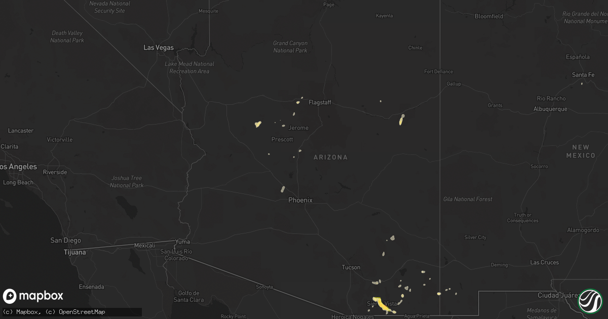
Hail Map in Arizona on August 7, 2022
Get this storm
August 7 map
$229
one time, instant access
Download today. No call, no setup
Keep the $229
Bought the map and want the full workflow? Apply the entire $229 to a subscription within 7 days. None of it is wasted.
Every map, not just this one
This buys you this map. Subscription and you get every map we run, in the markets you choose from a few cities to whole states to nationwide. Plus real-time alerts the moment a storm fires.
Contact data
Name, contact info, occupancy, even credit band for addresses in the footprint. You go from where it hit to who to call.
Become the source they trust
Unlimited branding weather history reports on demand. You already have the documented answer ready for the property owner, and you are the one who showed up with it.
Property data and RoofTrace estimates
Pull up any address you have got, its value and the exact code rules for that jurisdiction, straight from One Click Code. Then RoofTrace estimates the squares, pitch, and roof value, priced the way you price.
Storm reports in Arizona
Arizona
| Date | Description |
|---|---|
| 08/07/20224:02 AM CDT | At 902 PM MST, a severe thunderstorm was located near Corona De Tucson, or 15 miles east of Sahuarita, moving southwest at 10 mph. HAZARD...60 mph wind gusts and penny size hail. SOURCE...Radar indicated. IMPACT...Expect damage to roofs, siding, and trees. Locations impacted include... Sahuarita, Green Valley, Vail, East Sahuarita, Corona De Tucson and Madera Canyon. |
| 08/07/20223:59 AM CDT | At 859 PM MST, a severe thunderstorm was located near Buckeye, moving southwest at 15 mph. HAZARD...60 mph wind gusts and nickel size hail. SOURCE...Radar indicated. IMPACT...Expect damage to roofs, siding, and trees. Locations impacted include... Buckeye, Palo Verde, Hassayampa and Arlington. This includes the following highways...AZ Interstate 10 between mile markers 104 and 118.AZ Route 85 between mile markers 140 and 154. |
| 08/07/20223:20 AM CDT | At 820 PM MST, a severe thunderstorm was located 11 miles southeast of Vail, or 14 miles west of Benson, moving southwest at 10 mph. HAZARD...60 mph wind gusts and quarter size hail. SOURCE...Radar indicated. IMPACT...Hail damage to vehicles is expected. Expect wind damage to roofs, siding, and trees. Locations impacted include... Vail and Corona De Tucson. |
| 08/07/20222:59 AM CDT | At 759 PM MST, a severe thunderstorm was located near White Tank Mountain Park, or near Waddell, moving south at 5 mph. HAZARD...60 mph wind gusts and nickel size hail. SOURCE...Radar indicated. IMPACT...Expect damage to roofs, siding, and trees. Locations impacted include... Glendale, Surprise, Avondale, Goodyear, Buckeye, El Mirage, Sun City West, Waddell, Litchfield Park, White Tank Mountain Park, Luke AFB, Beardsley, Surprise Stadium and Vistancia.This includes the following highways...AZ Interstate 10 between mile markers 121 and 130.US Highway 60 between mile markers 129 and 144.AZ Route 303 between mile markers 105 and 123. |
| 08/07/20222:32 AM CDT | At 732 PM MST, a severe thunderstorm was located near Kartchner Caverns State Park, or near Benson, moving southwest at 25 mph. HAZARD...60 mph wind gusts and quarter size hail. SOURCE...Radar indicated. IMPACT...Hail damage to vehicles is expected. Expect wind damage to roofs, siding, and trees. Locations impacted include... Benson, Whetstone, St. David, Kartchner Caverns State Park, Mescal and Fairbank. |
| 08/07/20222:13 AM CDT | At 713 PM MST, a severe thunderstorm was located near Beardsley, or near Sun City West, moving south at 15 mph. HAZARD...60 mph wind gusts and nickel size hail. SOURCE...Radar indicated. IMPACT...Expect damage to roofs, siding, and trees. Locations impacted include... Peoria, Surprise, El Mirage, Youngtown, Sun City West, Sun City, Waddell, Wittmann, Lake Pleasant, Beardsley, Downtown Peoria, Surprise Stadium, Arrowhead Mall and Vistancia.This includes the following highways...US Highway 60 between mile markers 129 and 151.AZ Route 101 between mile markers 10 and 17.AZ Route 74 between mile markers 8 and 24. |
| 08/07/20222:08 AM CDT | At 707 PM MST, severe thunderstorms were located along a line extending from 8 miles south of Willcox to 9 miles southeast of Pearce-Sunsites to 12 miles north of Bisbee, moving southwest at 10 mph. HAZARD...60 mph wind gusts and quarter size hail. SOURCE...Radar indicated. IMPACT...Hail damage to vehicles is expected. Expect wind damage to roofs, siding, and trees. Locations impacted include... Bisbee, St. David, Tombstone, Naco, Dragoon, Pearce-Sunsites, Cochise, Elfrida, Sunizona, McNeal, Texas Canyon and Kansas Settlement. |
| 08/07/20221:41 AM CDT | At 641 PM MST, a severe thunderstorm was located near Huachuca City, or 15 miles northwest of Sierra Vista, moving northwest at 20 mph. HAZARD...60 mph wind gusts and half dollar size hail. SOURCE...Radar indicated. IMPACT...Hail damage to vehicles is expected. Expect wind damage to roofs, siding, and trees. Locations impacted include... Whetstone, Sonoita, Elgin and Fort Huachuca. |
| 08/07/20221:37 AM CDT | At 637 PM MST, a severe thunderstorm was located near Lake Pleasant, or 9 miles northwest of New River, moving south at 10 mph. HAZARD...60 mph wind gusts and quarter size hail. SOURCE...Radar indicated. IMPACT...Hail damage to vehicles is expected. Expect wind damage to roofs, siding, and trees. Locations impacted include... Lake Pleasant. |
| 08/07/20221:24 AM CDT | At 624 PM MST, a severe thunderstorm was located 13 miles southeast of Pearce-Sunsites, or 28 miles south of Willcox, moving west at 20 mph. HAZARD...60 mph wind gusts and quarter size hail. SOURCE...Radar indicated. IMPACT...Hail damage to vehicles is expected. Expect wind damage to roofs, siding, and trees. Locations impacted include... Pearce-Sunsites and Sunizona. |
| 08/07/20221:17 AM CDT | At 616 PM MST, a severe thunderstorm was located near Castle Hot Springs, or 12 miles northwest of New River, moving south at 10 mph. HAZARD...60 mph wind gusts and quarter size hail. SOURCE...Radar indicated. IMPACT...Hail damage to vehicles is expected. Expect wind damage to roofs, siding, and trees. Locations impacted include... Castle Hot Springs and Lake Pleasant. |
| 08/07/20221:15 AM CDT | At 614 PM MST, a severe thunderstorm was located near Castle Hot Springs, or 9 miles northwest of New River, moving south at 10 mph. HAZARD...60 mph wind gusts and nickel size hail. SOURCE...Radar indicated. IMPACT...Expect damage to roofs, siding, and trees. Locations impacted include... New River, Lake Pleasant and Anthem. This includes the following highways...AZ Interstate 17 between mile markers 227 and 241.AZ Route 74 between mile markers 13 and 22. |
| 08/07/20221:14 AM CDT | At 614 PM MST, a severe thunderstorm was located 14 miles west of Willcox, moving southwest at 20 mph. HAZARD...60 mph wind gusts and quarter size hail. SOURCE...Radar indicated. IMPACT...Hail damage to vehicles is expected. Expect wind damage to roofs, siding, and trees. This severe thunderstorm will remain over mainly remote areas of northwestern Cochise County. |
| 08/07/20221:06 AM CDT | At 605 PM MST, a severe thunderstorm was located near Sierra Vista, moving northwest at 20 mph. HAZARD...Golf ball size hail and 70 mph wind gusts. SOURCE...Radar indicated. IMPACT...People and animals outdoors will be injured. Expect hail damage to roofs, siding, windows, and vehicles. Expect considerable tree damage. Wind damage is also likely to mobile homes, roofs, and outbuildings. Locations impacted include... Sierra Vista, Whetstone, Huachuca City, Elgin, Fort Huachuca and Canelo. |
| 08/07/202212:39 AM CDT | At 538 PM MST, a severe thunderstorm was located 8 miles northeast of Woodruff, near the south entrance of Petrified Forest moving southwest at 25 mph. HAZARD...60 mph wind gusts and quarter size hail. SOURCE...Radar indicated. IMPACT...Hail damage to vehicles is expected. Expect wind damage to roofs, siding, and trees. Locations impacted include... Woodruff, Petrified Forest National Park and Petrified Forest N.P. Visitors Center. |
| 08/07/202212:26 AM CDT | At 526 PM MST, a severe thunderstorm was located over Hereford, or near Sierra Vista, moving west at 15 mph. HAZARD...60 mph wind gusts and quarter size hail. SOURCE...Radar indicated. IMPACT...Hail damage to vehicles is expected. Expect wind damage to roofs, siding, and trees. Locations impacted include... Sierra Vista, Hereford, Fort Huachuca, Palominas, Coronado National Memorial and Ramsey Canyon Preserve. |
| 08/06/202211:45 PM CDT | At 445 PM MST, a severe thunderstorm was located near Naco, or near Bisbee, moving west at 10 mph. HAZARD...60 mph wind gusts and quarter size hail. SOURCE...Radar indicated. IMPACT...Hail damage to vehicles is expected. Expect wind damage to roofs, siding, and trees. Locations impacted include... Sierra Vista, Bisbee, Hereford, Naco, Palominas and Coronado National Memorial. |
| 08/06/202211:19 PM CDT | At 419 PM MST, a severe thunderstorm was located over Miami, or near Globe, moving south at 15 mph. HAZARD...60 mph wind gusts and penny size hail. SOURCE...Radar indicated. IMPACT...Expect damage to roofs, siding, and trees. Locations impacted include... Globe, Miami, Central Heights-Midland City, Claypool, Top-Of-The-World and Inspiration.This includes the following highways...US Highway 60 between mile markers 235 and 253.AZ Route 70 near mile marker 253.AZ Route 77 between mile markers 157 and 164. |
| 08/06/202211:15 PM CDT | Two semis flipped on i-10 westbound causing both lanes to be temporarily blocked. |
| 08/06/202211:15 PM CDT | Buckeye azmet weather station. |
| 08/06/202211:15 PM CDT | Awos station kbxk buckeye. |
| 08/06/202210:14 PM CDT | At 313 PM MST, a severe thunderstorm was located near Perkinsville, or 13 miles northeast of Chino Valley, moving southwest at 10 mph. HAZARD...60 mph wind gusts and half dollar size hail. SOURCE...Radar indicated. IMPACT...Hail damage to vehicles is expected. Expect wind damage to roofs, siding, and trees. Locations impacted include... Chino Valley and Perkinsville. |
| 08/06/20229:50 PM CDT | Report of numerous downed trees in the surprise farms community including some having fallen on vehicles. |
| 08/06/20229:38 PM CDT | Report of power pole |
| 08/06/20229:38 PM CDT | Report of power pole |
| 08/06/20228:49 PM CDT | At 149 PM MST, a severe thunderstorm was located 8 miles west of Parker Canyon Lake and another storm over Parker Canyon Lake, or 20 miles east of Nogales, moving southwest at 15 mph. HAZARD...60 mph wind gusts and quarter size hail. SOURCE...Radar indicated. IMPACT...Hail damage to vehicles is expected. Expect wind damage to roofs, siding, and trees. Locations impacted include... Parker Canyon Lake, Kino Springs and Lochiel. |
| 08/06/20228:14 PM CDT | Trained spotters 3065 and 1807 reports quarter sized hail. |
| 08/06/20228:08 PM CDT | Public report received via social media of quarter-sized hail. |
| 08/06/20228:00 PM CDT | Personal weather station measured 74 mph wind gust. |
| 08/06/20227:50 PM CDT | A local report indicates 1.75 inch wind near 6 SE SIERRA VISTA |
| 08/06/20227:40 PM CDT | Spotter reported dime to quarter-sized hail. |
| 08/06/20227:40 PM CDT | Hail broke patio window. |
All States Impacted by Hail Map on August 7, 2022
Cities Impacted by Hail Map on August 7, 2022
- Ute, IA
- Southside, TN
- Arab, AL
- Florence, CO
- Coal Creek, CO
- Sharon Springs, KS
- Las Animas, CO
- Walsenburg, CO
- Tombstone, AZ
- Cochise, AZ
- Pearce, AZ
- Casey, IA
- Guthrie Center, IA
- Hasty, CO
- La Junta, CO
- Prescott, AZ
- San Simon, AZ
- Lumber City, GA
- Quitman, MS
- Melvin, AL
- Sugar City, CO
- Ordway, CO
- Arlington, CO
- West Des Moines, IA
- Des Moines, IA
- Windsor Heights, IA
- Trinidad, CO
- Lamar, CO
- Maplesville, AL
- Plantersville, AL
- Elfrida, AZ
- Winterset, IA
- Benson, AZ
- Surprise, AZ
- Model, CO
- Fort Huachuca, AZ
- Hereford, AZ
- Sierra Vista, AZ
- Longmont, CO
- Williams, AZ
- Mount Pleasant, TN
- Huachuca City, AZ
- Elgin, AZ
- Penrose, CO
- Lewisburg, KY
- Montgomery, AL
- Wetumpka, AL
- Lynnville, TN
- Culleoka, TN
- Holbrook, AZ
- Dexter, IA
- Earlham, IA
- Camilla, GA
- Tribune, KS
- Talladega, AL
- Livermore, CO
- Bisbee, AZ
- Monroe, IA
- Patagonia, AZ
- Lyons, CO
- Berthoud, CO
- Manzanola, CO
- Commerce City, CO
- Kit Carson, CO
- Rockford, AL
- Willcox, AZ
- Columbia, TN
- Decatur, AL
- Somerville, AL
- Mayer, AZ
- Hartselle, AL
- Saint James, LA
- Santa Fe, NM
- Denver, CO
- Audubon, IA
- Irwin, IA
- Kimballton, IA
- Kirkman, IA
- Hamlin, IA
- Exira, IA
- Chino Valley, AZ
- Kim, CO
- Pueblo, CO
- Des Arc, MO
- Annapolis, MO
- Franklin, KY
- Elk Horn, IA
- Brayton, IA
- Harlan, IA
- Aurora, CO
- Westminster, CO
- Chambers, AZ
- Adair, IA
- Anita, IA
- Dunmor, KY
- Johnston, IA
- Clive, IA
- Urbandale, IA
- Alexander City, AL
- Prairie City, IA
- Vinemont, AL
- Cullman, AL
- Ashland City, TN
- Nashville, TN
- Starkville, MS
- Crown King, AZ
- Animas, NM
- Winslow, AZ
- Clio, SC
- Sulligent, AL
- Gattman, MS
- Morris, GA
- Leoti, KS
- Lyles, TN
- Andalusia, AL
- Mapleton, IA
- Soldier, IA
- Dadeville, AL
- Eutaw, AL
- Florissant, CO
- Kirkland, AZ
- Van Meter, IA
- Adel, IA
- Booneville, IA
- Cumming, IA
- De Soto, IA
- Norwalk, IA
- Madison, TN
- Kellyton, AL
- Ganado, AZ
- Madison, NH
- Equality, AL
- Munford, AL
- Canon City, CO
- Boulder, CO
- Lafayette, CO
- Clarkson, KY
- Rodeo, NM
- Weskan, KS
- Tuscaloosa, AL
- Northport, AL
- Mitchellville, IA
- Runnells, IA
- Crescent, IA
- Danville, AL
- Wallace, KS
- Paulden, AZ
- Centerville, TN
- Lincoln, AL
- Eastaboga, AL
- Cumberland Furnace, TN
- Charlotte, TN
- Clanton, AL
- Billingsley, AL
- Trinchera, CO
- Gilman, IA
- Tama, IA
- Malcom, IA
- Laurel, IA
- Grinnell, IA
- Chelsea, IA
- Colfax, IA
- Newton, IA


