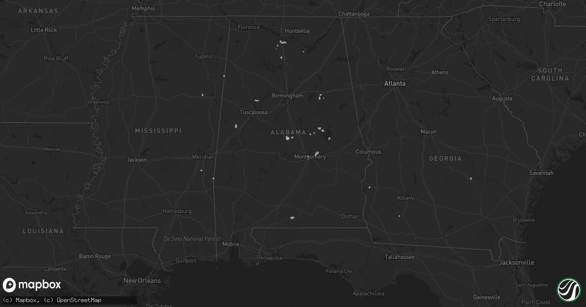
Hail Map in Alabama on August 7, 2022
Get this storm
August 7 map
$229
one time, instant access
Download today. No call, no setup
Keep the $229
Bought the map and want the full workflow? Apply the entire $229 to a subscription within 7 days. None of it is wasted.
Every map, not just this one
This buys you this map. Subscription and you get every map we run, in the markets you choose from a few cities to whole states to nationwide. Plus real-time alerts the moment a storm fires.
Contact data
Name, contact info, occupancy, even credit band for addresses in the footprint. You go from where it hit to who to call.
Become the source they trust
Unlimited branding weather history reports on demand. You already have the documented answer ready for the property owner, and you are the one who showed up with it.
Property data and RoofTrace estimates
Pull up any address you have got, its value and the exact code rules for that jurisdiction, straight from One Click Code. Then RoofTrace estimates the squares, pitch, and roof value, priced the way you price.
Storm reports in Alabama
Alabama
| Date | Description |
|---|---|
| 08/07/20222:37 PM CDT | Powerlines down in the industrial district along cherokkee ave/69 s. |
| 08/07/20221:55 PM CDT | Report of roof damage... Tree onto a barn... And 12 inch diameter tree down in the west point area. Time estimated by radar. |
| 08/07/202212:40 PM CDT | Social media post of power outages and trees down in leighton. |
| 08/07/20222:50 AM CDT | At 750 PM CDT, a severe thunderstorm was located over Emerald Mountain, or 7 miles southeast of Wetumpka, moving southwest at 15 mph. HAZARD...60 mph wind gusts and penny size hail. SOURCE...Radar indicated. IMPACT...Expect damage to roofs, siding, and trees. Locations impacted include... Eastern Montgomery, Emerald Mountain, Eastdale Mall, Mount Meigs, Montgomery Zoo, Auburn University In Montgomery, Lagoon Park, Gunter Air Force Base, Blue Ridge, Brassell, Mitylene and Tallapoosa Water Plant. |
| 08/07/20221:49 AM CDT | At 649 PM CDT, a severe thunderstorm was located near Wind Creek State Park, or near Alexander City, moving southwest at 5 mph. HAZARD...60 mph wind gusts and penny size hail. SOURCE...Radar indicated. IMPACT...Expect damage to roofs, siding, and trees. Locations impacted include... Alexander City, Rockford, Speed, Pentonville, Cottage Grove, Highway 9 and Highway 22, Nixburg, Wind Creek State Park, Eastern Lake Martin, Northern Lake Martin, Western Lake Martin, Fishpond, Ray and Hissop. |
| 08/07/20221:01 AM CDT | At 600 PM EDT, a severe thunderstorm was located over Green Island Hills, or near Columbus, moving west at 10 mph. HAZARD...60 mph wind gusts. SOURCE...Radar indicated. IMPACT...Expect damage to roofs, siding, and trees. Locations impacted include... Columbus, Bibb City, Saint Marys Hills, Edgewood, Highland Park, Laurel Hills, Green Island Hills, Kenwood, Vista Terrace, Avondale, Columbus Metropolitan Airport and Rose Hill. |
| 08/07/202212:34 AM CDT | At 533 PM CDT, severe thunderstorms were located along a line extending from near Talladega to near Winterboro, moving north at 15 mph. HAZARD...60 mph wind gusts. SOURCE...Radar indicated. IMPACT...Expect damage to roofs, siding, and trees. Locations impacted include... Talladega, Waldo and Jackson Shoals. |
| 08/07/202212:26 AM CDT | At 526 PM CDT, a severe thunderstorm was located over Plecher, or 12 miles southwest of Clanton, and is nearly stationary. HAZARD...60 mph wind gusts and penny size hail. SOURCE...Radar indicated. IMPACT...Expect damage to roofs, siding, and trees. Locations impacted include... Billingsley, Plecher and Pooles Crossroads. |
| 08/06/202210:14 PM CDT | At 314 PM CDT, a severe thunderstorm was located near Arab, moving northwest at 15 mph. HAZARD...60 mph wind gusts and quarter size hail. SOURCE...Radar indicated. IMPACT...Hail damage to vehicles is expected. Expect wind damage to roofs, siding, and trees. Locations impacted include... Arab, Union Grove and Eddy. |
| 08/06/20229:33 PM CDT | At 233 PM CDT, a severe thunderstorm was located over Good Hope, or near Cullman, moving southeast at 15 mph. HAZARD...60 mph wind gusts and penny size hail. SOURCE...Radar indicated. IMPACT...Expect damage to roofs, siding, and trees. Locations impacted include... Cullman, Hanceville, Good Hope, Dodge City, Baldwin, Vinemont, Garden City, Colony, Phelan and Black Bottom. |
| 08/06/20228:08 PM CDT | Tree down near the intersection of fire tower rd and jug factory rd. |
All States Impacted by Hail Map on August 7, 2022
Cities Impacted by Hail Map on August 7, 2022
- Ute, IA
- Southside, TN
- Arab, AL
- Florence, CO
- Coal Creek, CO
- Sharon Springs, KS
- Las Animas, CO
- Walsenburg, CO
- Tombstone, AZ
- Cochise, AZ
- Pearce, AZ
- Casey, IA
- Guthrie Center, IA
- Hasty, CO
- La Junta, CO
- Prescott, AZ
- San Simon, AZ
- Lumber City, GA
- Quitman, MS
- Melvin, AL
- Sugar City, CO
- Ordway, CO
- Arlington, CO
- West Des Moines, IA
- Des Moines, IA
- Windsor Heights, IA
- Trinidad, CO
- Lamar, CO
- Maplesville, AL
- Plantersville, AL
- Elfrida, AZ
- Winterset, IA
- Benson, AZ
- Surprise, AZ
- Model, CO
- Fort Huachuca, AZ
- Hereford, AZ
- Sierra Vista, AZ
- Longmont, CO
- Williams, AZ
- Mount Pleasant, TN
- Huachuca City, AZ
- Elgin, AZ
- Penrose, CO
- Lewisburg, KY
- Montgomery, AL
- Wetumpka, AL
- Lynnville, TN
- Culleoka, TN
- Holbrook, AZ
- Dexter, IA
- Earlham, IA
- Camilla, GA
- Tribune, KS
- Talladega, AL
- Livermore, CO
- Bisbee, AZ
- Monroe, IA
- Patagonia, AZ
- Lyons, CO
- Berthoud, CO
- Manzanola, CO
- Commerce City, CO
- Kit Carson, CO
- Rockford, AL
- Willcox, AZ
- Columbia, TN
- Decatur, AL
- Somerville, AL
- Mayer, AZ
- Hartselle, AL
- Saint James, LA
- Santa Fe, NM
- Denver, CO
- Audubon, IA
- Irwin, IA
- Kimballton, IA
- Kirkman, IA
- Hamlin, IA
- Exira, IA
- Chino Valley, AZ
- Kim, CO
- Pueblo, CO
- Des Arc, MO
- Annapolis, MO
- Franklin, KY
- Elk Horn, IA
- Brayton, IA
- Harlan, IA
- Aurora, CO
- Westminster, CO
- Chambers, AZ
- Adair, IA
- Anita, IA
- Dunmor, KY
- Johnston, IA
- Clive, IA
- Urbandale, IA
- Alexander City, AL
- Prairie City, IA
- Vinemont, AL
- Cullman, AL
- Ashland City, TN
- Nashville, TN
- Starkville, MS
- Crown King, AZ
- Animas, NM
- Winslow, AZ
- Clio, SC
- Sulligent, AL
- Gattman, MS
- Morris, GA
- Leoti, KS
- Lyles, TN
- Andalusia, AL
- Mapleton, IA
- Soldier, IA
- Dadeville, AL
- Eutaw, AL
- Florissant, CO
- Kirkland, AZ
- Van Meter, IA
- Adel, IA
- Booneville, IA
- Cumming, IA
- De Soto, IA
- Norwalk, IA
- Madison, TN
- Kellyton, AL
- Ganado, AZ
- Madison, NH
- Equality, AL
- Munford, AL
- Canon City, CO
- Boulder, CO
- Lafayette, CO
- Clarkson, KY
- Rodeo, NM
- Weskan, KS
- Tuscaloosa, AL
- Northport, AL
- Mitchellville, IA
- Runnells, IA
- Crescent, IA
- Danville, AL
- Wallace, KS
- Paulden, AZ
- Centerville, TN
- Lincoln, AL
- Eastaboga, AL
- Cumberland Furnace, TN
- Charlotte, TN
- Clanton, AL
- Billingsley, AL
- Trinchera, CO
- Gilman, IA
- Tama, IA
- Malcom, IA
- Laurel, IA
- Grinnell, IA
- Chelsea, IA
- Colfax, IA
- Newton, IA


