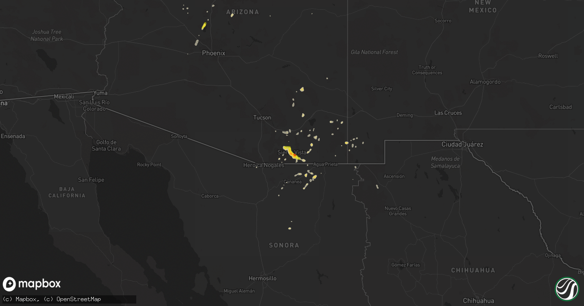
Hail Map on August 7, 2022
Get this storm
August 7 map
$229
one time, instant access
Download today. No call, no setup
Keep the $229
Bought the map and want the full workflow? Apply the entire $229 to a subscription within 7 days. None of it is wasted.
Every map, not just this one
This buys you this map. Subscription and you get every map we run, in the markets you choose from a few cities to whole states to nationwide. Plus real-time alerts the moment a storm fires.
Contact data
Name, contact info, occupancy, even credit band for addresses in the footprint. You go from where it hit to who to call.
Become the source they trust
Unlimited branding weather history reports on demand. You already have the documented answer ready for the property owner, and you are the one who showed up with it.
Property data and RoofTrace estimates
Pull up any address you have got, its value and the exact code rules for that jurisdiction, straight from One Click Code. Then RoofTrace estimates the squares, pitch, and roof value, priced the way you price.
States Impacted by Hail Map on August 7, 2022
Storm reports
Indiana
| Date | Description |
|---|---|
| 08/07/20221:26 PM CDT | Power line downed east of kouts on county road 450 e north of the intersection with state route 8. Time estimated from radar. |
| 08/07/20227:53 AM CDT | At 1253 PM CDT, a severe thunderstorm was located near Shelby, or near Lowell, moving east at 35 mph. HAZARD...60 mph wind gusts. SOURCE...Radar indicated. IMPACT...Expect damage to roofs, siding, and trees. Locations impacted include... DeMotte, Hebron, Wheatfield, Roselawn, Kouts, Dunns Bridge, Baileys Corner, Stoutsburg and Fair Oaks.Including the following interstate... Indiana I-65 between mile markers 225 and 232. |
| 08/07/20227:32 AM CDT | At 1232 PM CDT, a severe thunderstorm was located near Grant Park, or 8 miles northeast of Momence, moving east at 25 mph. HAZARD...60 mph wind gusts. SOURCE...Radar indicated. IMPACT...Expect damage to roofs, siding, and trees. Locations impacted include... Lowell, Momence, Lake Village, Roselawn, Lake Dalecarlia, Grant Park, Shelby, Schneider, Sumava Resorts and Thayer.Including the following interstate... Indiana I-65 between mile markers 233 and 243. |
| 08/06/20229:15 PM CDT | At 215 PM EDT/115 PM CDT/, a severe thunderstorm was located over Dunns Bridge, moving east at 35 mph. HAZARD...60 mph wind gusts. SOURCE...Radar indicated. IMPACT...Expect damage to roofs, siding, and trees. Locations impacted include... Plymouth, Knox, Winamac, North Judson, Culver, Francesville, Medaryville, Pulaski, Oak Grove, Ripley, Kewanna, Monterey, Leiters Ford, Lomax, Beardstown, Ober, English Lake, Denham, Hibbard and Clarks. |
New Hampshire
| Date | Description |
|---|---|
| 08/07/20226:08 PM CDT | Large tree down on idlewild road. Home weather station clocked wind gust to 63mph. Time estimated by radar. |
| 08/07/20226:04 PM CDT | Wind gusts ripped down branches on west shore of second connecticut lake. Time estimated by radar. |
| 08/07/20224:22 PM CDT | Social media reports of trees and branches down on davis hill rd. Time estimated by radar. |
| 08/07/20224:22 PM CDT | Reports of trees down around the area. |
| 08/07/20224:22 PM CDT | Observed 1-1.25 inch hail on south end of conway lake. Very strong winds knocked down several branches. Reports of trees down around the area. Time estimated by radar. |
| 08/07/20223:46 PM CDT | Social media photo and report of quarter-sized hail on the west side of conway. Hail fell very briefly and was accompanied by strong winds. Time estimated by radar. |
| 08/07/20222:37 PM CDT | Several reports of down tree limbs and penny size hail in the parrish hill neighborhood on the west end of nashua. Time estimated by radar. |
| 08/07/20222:32 PM CDT | 10-inch diameter tree down on a garage. No injuries. Time estimated by radar. |
| 08/07/20222:27 PM CDT | Social media reports of tree limbs scattered across nh hwy 136 near the lake. Time estimated by radar. |
| 08/07/20222:27 PM CDT | Large tree down across hwy 130. |
| 08/07/20222:04 PM CDT | Hail and strong winds knocked down numerous tree branches south of bennington. Hail measured between 3/4-1 inch; fell for about 6 minutes. Time estimated by radar. |
| 08/07/20221:35 PM CDT | Strong winds knocked down a few trees on the east end of harrisville pond. Kestrel-measured at 46mph. |
| 08/07/202212:20 AM CDT | At 520 PM EDT, a severe thunderstorm was located near Conway, moving east at 20 mph. HAZARD...60 mph wind gusts and half dollar size hail. SOURCE...Radar indicated. IMPACT...Hail damage to vehicles is expected. Expect wind damage to roofs, siding, and trees. Locations impacted include... Conway, Bridgton, Fryeburg, Naples, Ossipee, Buxton, Hollis, Hiram, Effingham, Cornish, Standish, Raymond, Waterboro, Casco, Limington, Limerick, Madison, Brownfield, Freedom and Denmark. |
| 08/06/202210:22 PM CDT | At 321 PM EDT, a severe thunderstorm was located over New Boston, or 11 miles west of Manchester, moving east at 35 mph. HAZARD...60 mph wind gusts and quarter size hail. SOURCE...Radar indicated. IMPACT...Hail damage to vehicles is expected. Expect wind damage to roofs, siding, and trees. Locations impacted include... Manchester, Concord, Derry, Henniker, Merrimack, Northwood, Bedford, Milford, Hooksett, Amherst, Litchfield, Epping, Hopkinton, New Boston, Epsom, Brentwood, Mont Vernon, Lyndeborough, Francestown and Raymond.This includes the following highways... Interstate 293 between mile markers 1 and 11. Interstate 89 between mile markers 0 and 10. Interstate 93 between mile markers 10 and 40. |
Georgia
| Date | Description |
|---|---|
| 08/07/20224:53 PM CDT | Asos station kcsg columbus. |
Connecticut
| Date | Description |
|---|---|
| 08/07/20224:48 PM CDT | In suffield... A tree fell on two cars on barndoor hills drive. |
Arizona
| Date | Description |
|---|---|
| 08/07/20224:02 AM CDT | At 902 PM MST, a severe thunderstorm was located near Corona De Tucson, or 15 miles east of Sahuarita, moving southwest at 10 mph. HAZARD...60 mph wind gusts and penny size hail. SOURCE...Radar indicated. IMPACT...Expect damage to roofs, siding, and trees. Locations impacted include... Sahuarita, Green Valley, Vail, East Sahuarita, Corona De Tucson and Madera Canyon. |
| 08/07/20223:59 AM CDT | At 859 PM MST, a severe thunderstorm was located near Buckeye, moving southwest at 15 mph. HAZARD...60 mph wind gusts and nickel size hail. SOURCE...Radar indicated. IMPACT...Expect damage to roofs, siding, and trees. Locations impacted include... Buckeye, Palo Verde, Hassayampa and Arlington. This includes the following highways...AZ Interstate 10 between mile markers 104 and 118.AZ Route 85 between mile markers 140 and 154. |
| 08/07/20223:20 AM CDT | At 820 PM MST, a severe thunderstorm was located 11 miles southeast of Vail, or 14 miles west of Benson, moving southwest at 10 mph. HAZARD...60 mph wind gusts and quarter size hail. SOURCE...Radar indicated. IMPACT...Hail damage to vehicles is expected. Expect wind damage to roofs, siding, and trees. Locations impacted include... Vail and Corona De Tucson. |
| 08/07/20222:59 AM CDT | At 759 PM MST, a severe thunderstorm was located near White Tank Mountain Park, or near Waddell, moving south at 5 mph. HAZARD...60 mph wind gusts and nickel size hail. SOURCE...Radar indicated. IMPACT...Expect damage to roofs, siding, and trees. Locations impacted include... Glendale, Surprise, Avondale, Goodyear, Buckeye, El Mirage, Sun City West, Waddell, Litchfield Park, White Tank Mountain Park, Luke AFB, Beardsley, Surprise Stadium and Vistancia.This includes the following highways...AZ Interstate 10 between mile markers 121 and 130.US Highway 60 between mile markers 129 and 144.AZ Route 303 between mile markers 105 and 123. |
| 08/07/20222:32 AM CDT | At 732 PM MST, a severe thunderstorm was located near Kartchner Caverns State Park, or near Benson, moving southwest at 25 mph. HAZARD...60 mph wind gusts and quarter size hail. SOURCE...Radar indicated. IMPACT...Hail damage to vehicles is expected. Expect wind damage to roofs, siding, and trees. Locations impacted include... Benson, Whetstone, St. David, Kartchner Caverns State Park, Mescal and Fairbank. |
| 08/07/20222:13 AM CDT | At 713 PM MST, a severe thunderstorm was located near Beardsley, or near Sun City West, moving south at 15 mph. HAZARD...60 mph wind gusts and nickel size hail. SOURCE...Radar indicated. IMPACT...Expect damage to roofs, siding, and trees. Locations impacted include... Peoria, Surprise, El Mirage, Youngtown, Sun City West, Sun City, Waddell, Wittmann, Lake Pleasant, Beardsley, Downtown Peoria, Surprise Stadium, Arrowhead Mall and Vistancia.This includes the following highways...US Highway 60 between mile markers 129 and 151.AZ Route 101 between mile markers 10 and 17.AZ Route 74 between mile markers 8 and 24. |
| 08/07/20222:08 AM CDT | At 707 PM MST, severe thunderstorms were located along a line extending from 8 miles south of Willcox to 9 miles southeast of Pearce-Sunsites to 12 miles north of Bisbee, moving southwest at 10 mph. HAZARD...60 mph wind gusts and quarter size hail. SOURCE...Radar indicated. IMPACT...Hail damage to vehicles is expected. Expect wind damage to roofs, siding, and trees. Locations impacted include... Bisbee, St. David, Tombstone, Naco, Dragoon, Pearce-Sunsites, Cochise, Elfrida, Sunizona, McNeal, Texas Canyon and Kansas Settlement. |
| 08/07/20221:41 AM CDT | At 641 PM MST, a severe thunderstorm was located near Huachuca City, or 15 miles northwest of Sierra Vista, moving northwest at 20 mph. HAZARD...60 mph wind gusts and half dollar size hail. SOURCE...Radar indicated. IMPACT...Hail damage to vehicles is expected. Expect wind damage to roofs, siding, and trees. Locations impacted include... Whetstone, Sonoita, Elgin and Fort Huachuca. |
| 08/07/20221:37 AM CDT | At 637 PM MST, a severe thunderstorm was located near Lake Pleasant, or 9 miles northwest of New River, moving south at 10 mph. HAZARD...60 mph wind gusts and quarter size hail. SOURCE...Radar indicated. IMPACT...Hail damage to vehicles is expected. Expect wind damage to roofs, siding, and trees. Locations impacted include... Lake Pleasant. |
| 08/07/20221:24 AM CDT | At 624 PM MST, a severe thunderstorm was located 13 miles southeast of Pearce-Sunsites, or 28 miles south of Willcox, moving west at 20 mph. HAZARD...60 mph wind gusts and quarter size hail. SOURCE...Radar indicated. IMPACT...Hail damage to vehicles is expected. Expect wind damage to roofs, siding, and trees. Locations impacted include... Pearce-Sunsites and Sunizona. |
| 08/07/20221:17 AM CDT | At 616 PM MST, a severe thunderstorm was located near Castle Hot Springs, or 12 miles northwest of New River, moving south at 10 mph. HAZARD...60 mph wind gusts and quarter size hail. SOURCE...Radar indicated. IMPACT...Hail damage to vehicles is expected. Expect wind damage to roofs, siding, and trees. Locations impacted include... Castle Hot Springs and Lake Pleasant. |
| 08/07/20221:15 AM CDT | At 614 PM MST, a severe thunderstorm was located near Castle Hot Springs, or 9 miles northwest of New River, moving south at 10 mph. HAZARD...60 mph wind gusts and nickel size hail. SOURCE...Radar indicated. IMPACT...Expect damage to roofs, siding, and trees. Locations impacted include... New River, Lake Pleasant and Anthem. This includes the following highways...AZ Interstate 17 between mile markers 227 and 241.AZ Route 74 between mile markers 13 and 22. |
| 08/07/20221:14 AM CDT | At 614 PM MST, a severe thunderstorm was located 14 miles west of Willcox, moving southwest at 20 mph. HAZARD...60 mph wind gusts and quarter size hail. SOURCE...Radar indicated. IMPACT...Hail damage to vehicles is expected. Expect wind damage to roofs, siding, and trees. This severe thunderstorm will remain over mainly remote areas of northwestern Cochise County. |
| 08/07/20221:06 AM CDT | At 605 PM MST, a severe thunderstorm was located near Sierra Vista, moving northwest at 20 mph. HAZARD...Golf ball size hail and 70 mph wind gusts. SOURCE...Radar indicated. IMPACT...People and animals outdoors will be injured. Expect hail damage to roofs, siding, windows, and vehicles. Expect considerable tree damage. Wind damage is also likely to mobile homes, roofs, and outbuildings. Locations impacted include... Sierra Vista, Whetstone, Huachuca City, Elgin, Fort Huachuca and Canelo. |
| 08/07/202212:39 AM CDT | At 538 PM MST, a severe thunderstorm was located 8 miles northeast of Woodruff, near the south entrance of Petrified Forest moving southwest at 25 mph. HAZARD...60 mph wind gusts and quarter size hail. SOURCE...Radar indicated. IMPACT...Hail damage to vehicles is expected. Expect wind damage to roofs, siding, and trees. Locations impacted include... Woodruff, Petrified Forest National Park and Petrified Forest N.P. Visitors Center. |
| 08/07/202212:26 AM CDT | At 526 PM MST, a severe thunderstorm was located over Hereford, or near Sierra Vista, moving west at 15 mph. HAZARD...60 mph wind gusts and quarter size hail. SOURCE...Radar indicated. IMPACT...Hail damage to vehicles is expected. Expect wind damage to roofs, siding, and trees. Locations impacted include... Sierra Vista, Hereford, Fort Huachuca, Palominas, Coronado National Memorial and Ramsey Canyon Preserve. |
| 08/06/202211:45 PM CDT | At 445 PM MST, a severe thunderstorm was located near Naco, or near Bisbee, moving west at 10 mph. HAZARD...60 mph wind gusts and quarter size hail. SOURCE...Radar indicated. IMPACT...Hail damage to vehicles is expected. Expect wind damage to roofs, siding, and trees. Locations impacted include... Sierra Vista, Bisbee, Hereford, Naco, Palominas and Coronado National Memorial. |
| 08/06/202211:19 PM CDT | At 419 PM MST, a severe thunderstorm was located over Miami, or near Globe, moving south at 15 mph. HAZARD...60 mph wind gusts and penny size hail. SOURCE...Radar indicated. IMPACT...Expect damage to roofs, siding, and trees. Locations impacted include... Globe, Miami, Central Heights-Midland City, Claypool, Top-Of-The-World and Inspiration.This includes the following highways...US Highway 60 between mile markers 235 and 253.AZ Route 70 near mile marker 253.AZ Route 77 between mile markers 157 and 164. |
| 08/06/202211:15 PM CDT | Two semis flipped on i-10 westbound causing both lanes to be temporarily blocked. |
| 08/06/202211:15 PM CDT | Buckeye azmet weather station. |
| 08/06/202211:15 PM CDT | Awos station kbxk buckeye. |
| 08/06/202210:14 PM CDT | At 313 PM MST, a severe thunderstorm was located near Perkinsville, or 13 miles northeast of Chino Valley, moving southwest at 10 mph. HAZARD...60 mph wind gusts and half dollar size hail. SOURCE...Radar indicated. IMPACT...Hail damage to vehicles is expected. Expect wind damage to roofs, siding, and trees. Locations impacted include... Chino Valley and Perkinsville. |
| 08/06/20229:50 PM CDT | Report of numerous downed trees in the surprise farms community including some having fallen on vehicles. |
| 08/06/20229:38 PM CDT | Report of power pole |
| 08/06/20229:38 PM CDT | Report of power pole |
| 08/06/20228:49 PM CDT | At 149 PM MST, a severe thunderstorm was located 8 miles west of Parker Canyon Lake and another storm over Parker Canyon Lake, or 20 miles east of Nogales, moving southwest at 15 mph. HAZARD...60 mph wind gusts and quarter size hail. SOURCE...Radar indicated. IMPACT...Hail damage to vehicles is expected. Expect wind damage to roofs, siding, and trees. Locations impacted include... Parker Canyon Lake, Kino Springs and Lochiel. |
| 08/06/20228:14 PM CDT | Trained spotters 3065 and 1807 reports quarter sized hail. |
| 08/06/20228:08 PM CDT | Public report received via social media of quarter-sized hail. |
| 08/06/20228:00 PM CDT | Personal weather station measured 74 mph wind gust. |
| 08/06/20227:50 PM CDT | A local report indicates 1.75 inch wind near 6 SE SIERRA VISTA |
| 08/06/20227:40 PM CDT | Hail broke patio window. |
| 08/06/20227:40 PM CDT | Spotter reported dime to quarter-sized hail. |
Kansas
| Date | Description |
|---|---|
| 08/06/20229:52 PM CDT | At 252 PM MDT, a severe thunderstorm was located 16 miles south of Tribune, moving north at 10 mph. HAZARD...60 mph wind gusts and nickel size hail. SOURCE...Radar indicated. IMPACT...Expect damage to roofs, siding, and trees. This severe thunderstorm will remain over mainly rural areas of southern Greeley County. |
Colorado
| Date | Description |
|---|---|
| 08/07/20226:14 PM CDT | Structure thrown into road. |
| 08/07/20224:34 PM CDT | Corrects previous hail report from 5 e cheraw. |
| 08/07/20224:34 PM CDT | A local report indicates 1.00 inch wind near 5 E CHERAW |
| 08/07/20221:01 AM CDT | At 601 PM MDT, a severe thunderstorm was located over John Martin Reservoir, or 23 miles west of Lamar, moving west at 15 mph. HAZARD...60 mph wind gusts and quarter size hail. SOURCE...Radar indicated. IMPACT...Hail damage to vehicles is expected. Expect wind damage to roofs, siding, and trees. Locations impacted include... Las Animas, McClave, Hasty, John Martin Reservoir, Blue Lake, Fort Lyon and Caddoa. |
| 08/06/202211:48 PM CDT | At 448 PM MDT, a severe thunderstorm were developing over the warned area, and are nearly stationary. HAZARD...60 mph wind gusts and quarter size hail. SOURCE...Radar indicated. IMPACT...Hail damage to vehicles is expected. Expect wind damage to roofs, siding, and trees. Locations impacted include... Lamar, Granada, Wiley, Hartman, Neeoshe Reservoir, Bristol, Neegronda Reservoir, Queens Reservoir and Sweetwater Reservoir. |
| 08/06/202210:44 PM CDT | At 344 PM MDT, severe thunderstorms were located along a line extending from Blue Lake to near Las Animas, moving east at 15 mph. HAZARD...60 mph wind gusts and half dollar size hail. SOURCE...Radar indicated. IMPACT...Hail damage to vehicles is expected. Expect wind damage to roofs, siding, and trees. Locations impacted include... Las Animas, Hasty, McClave, John Martin Reservoir, Fort Lyon and Caddoa. |
| 08/06/202210:17 PM CDT | At 316 PM MDT, severe thunderstorms were located along a line extending from near Arlington to Cheraw, moving east at 10 mph. HAZARD...60 mph wind gusts and quarter size hail. SOURCE...Radar indicated. IMPACT...Hail damage to vehicles is expected. Expect wind damage to roofs, siding, and trees. Severe thunderstorms will be near... Blue Lake around 330 PM MDT.Other locations in the path of these severe thunderstorms include LasAnimas and John Martin Reservoir. |
| 08/06/20229:39 PM CDT | At 239 PM MDT, severe thunderstorms were located along a line extending from 10 miles northwest of Arlington to 6 miles east of Sugar City to near Crowley, moving south at 15 mph. HAZARD...Golf ball size hail and 60 mph wind gusts. SOURCE...Radar indicated. IMPACT...People and animals outdoors will be injured. Expect hail damage to roofs, siding, windows, and vehicles. Expect wind damage to roofs, siding, and trees. Locations impacted include... Ordway, Sugar City, Crowley and Arlington. |
| 08/06/20229:21 PM CDT | Car smashed by large tree. |
| 08/06/20228:55 PM CDT | Delayed report: awos station k1v6 fremont county arpt. |
| 08/06/20227:48 PM CDT | A local report indicates 60 MPH wind near 3 N DENVER |
New Mexico
| Date | Description |
|---|---|
| 08/07/20221:07 AM CDT | At 607 PM MDT, a severe thunderstorm was located over Eldorado At Santa Fe, or 10 miles south of Santa Fe, and is nearly stationary. HAZARD...60 mph wind gusts and penny size hail. SOURCE...Radar indicated. IMPACT...Expect damage to roofs, siding, and trees. Locations impacted include... Eldorado At Santa Fe, Lamy and Canada De Los Alamos. This includes the following highways... Interstate 25 between Mile Markers 285 and 292. Highway 285 between Mile Markers 283 and 290. |
Texas
| Date | Description |
|---|---|
| 08/07/20226:18 PM CDT | West texas mesonet |
Iowa
| Date | Description |
|---|---|
| 08/07/20226:51 PM CDT | Public tweet indicating a large tree had fallen and taken down powerlines. Time estimated from radar. |
| 08/07/20223:42 AM CDT | At 842 PM CDT, a severe thunderstorm was located near Winterset, moving east at 25 mph. HAZARD...60 mph wind gusts and quarter size hail. SOURCE...Radar indicated. IMPACT...Hail damage to vehicles is expected. Expect wind damage to roofs, siding, and trees. This severe thunderstorm will be near... Patterson around 855 PM CDT.Other locations in the path of this severe thunderstorm includeBevington, Martensdale, Cumming, Spring Hill and Norwalk.This includes Interstate 35 between mile markers 55 and 66. |
| 08/07/20222:54 AM CDT | At 754 PM CDT, a severe thunderstorm was located 7 miles north of Grinnell, moving east at 35 mph. HAZARD...60 mph wind gusts and penny size hail. SOURCE...Radar indicated. IMPACT...Expect damage to roofs, siding, and trees. This severe thunderstorm will be near... Tama around 810 PM CDT.Other locations in the path of this severe thunderstorm includeHoliday Lake, Chelsea, Vining and Elberon. |
| 08/07/20222:12 AM CDT | At 712 PM CDT, a severe thunderstorm was located over Baxter, or 9 miles northwest of Newton, moving east at 20 mph. HAZARD...60 mph wind gusts and penny size hail. SOURCE...Radar indicated. IMPACT...Expect damage to roofs, siding, and trees. Locations impacted include... Haverhill, Laurel and Ferguson. |
| 08/07/202212:48 AM CDT | At 548 PM CDT, a severe thunderstorm was located 8 miles southwest of Audubon, moving east at 25 mph. HAZARD...60 mph wind gusts and quarter size hail. SOURCE...Radar indicated. IMPACT...Hail damage to vehicles is expected. Expect wind damage to roofs, siding, and trees. Locations impacted include... Audubon, Audubon County Airport and Exira. |
New Jersey
| Date | Description |
|---|---|
| 08/07/20221:31 PM CDT | Tree down on car at 6th street and 1st avenue. |
| 08/07/20221:30 PM CDT | Tree down on heather lane. The tree brought down power lines and damaged vehicles. |
| 08/07/20221:25 PM CDT | Wires down on coolidge street and erudo street |
| 08/06/20229:31 PM CDT | At 230 PM EDT, a severe thunderstorm was located over Linden, moving northeast at 30 mph. HAZARD...60 mph wind gusts. SOURCE...Radar indicated. IMPACT...Expect damage to trees and power lines. This severe thunderstorm will be near... Todt Hill and Port Richmond around 235 PM EDT. Newark and Bayonne around 240 PM EDT. Harrison and The Verrazano Narrows Bridge around 245 PM EDT. Jersey City and Kearny around 250 PM EDT. |
Mississippi
| Date | Description |
|---|---|
| 08/07/20226:05 PM CDT | Multiple trees downed in the area of oak hill drive. Possible downburst. |
Massachusetts
| Date | Description |
|---|---|
| 08/07/20226:46 PM CDT | In revere... A tree was down on high tension wires on cooledge street. Relayed by amateur radio. |
| 08/07/20226:39 PM CDT | In swampscott... A tree was into a house. |
| 08/07/20226:36 PM CDT | In danvers between 736 pm and 743 pm... Winds were estimated at 60 mph by an amateur radio spotter. A large limb and wires were down on collins street. A large limb was |
| 08/07/20226:35 PM CDT | In peabody... Tree down on power lines at lynnfield street and at columbia boulevard. Tree down on truck at norfolk avenue. Tree down at bartlett street. |
| 08/07/20226:34 PM CDT | In lynn... A tree was down on power lines on the 100 block of wyman street. Also... A tree was down on power lines on claremont street. |
| 08/07/20226:31 PM CDT | In somerville... A tree was down on a house on vernon street and a large branch was down on power lines on walker street. |
| 08/07/20226:27 PM CDT | In medford... Multiple trees were reported downed. |
| 08/07/20226:25 PM CDT | In arlington... Numerous trees and wires were downed. Locations included... Charles street... Stowecroft road... Walnut street... Kipling road and kensington park. |
| 08/07/20226:19 PM CDT | In winchester... Tree down at cambridge street by the boat club... Tree down on wires at 30 block of allen road... Large tree down on house which took chimney off the h |
| 08/07/20226:17 PM CDT | In waltham... Multiple trees were down... At wyman street at trapelo road and at marguerite avenue at trapelo road. |
| 08/07/20226:15 PM CDT | In lincoln two large trees down with wires down at old concord road... Tree down on route 126... Large branch down at 1400 block of concord road... And tree down on wir |
| 08/07/20226:14 PM CDT | In weston... Tree down at highland street at lexington street at spring road. Tree on to wires at merriam street at jones road and at church street near rail trail entr |
| 08/07/20226:10 PM CDT | In lexington... A large tree was down on fairview avenue. Relayed by amateur radio. |
| 08/07/20225:53 PM CDT | In stow... A tree was down on the 200 block of box mill road and another tree was down on the 400 block of taylor road. Relayed by amateur radio. |
| 08/07/20225:45 PM CDT | In berlin... A tree was down on pleasant street and a large limb down at pleasant street and kendall lane. A tree was down on a guardrail on coburn road and west street |
| 08/07/20225:37 PM CDT | In west boylston... A small branch was down on wires at the intersection of maple and temple streets. |
| 08/07/20225:27 PM CDT | In holden... A tree was down on a house... Causing some damage to the house... On glenwood street. Relayed by amateur radio. |
| 08/07/20224:55 PM CDT | In springfield... A power pole was downed onto a house on eleanor road. Also... A few homes away... Wires were reported downed on eleanor road. |
| 08/07/20224:49 PM CDT | In springfield... Wires were down on blodgett street. |
| 08/07/20224:49 PM CDT | In springfield... A tree was down on a vehicle and wires were down...both on hartwick street. |
| 08/07/20222:30 AM CDT | At 729 PM EDT, a severe thunderstorm was located over Malden, moving east at 45 mph. HAZARD...60 mph wind gusts. SOURCE...Trained weather spotters. IMPACT...Expect damage to trees and power lines. Locations impacted include... Boston, Cambridge, Lynn, Somerville, Malden, Medford, Revere, Peabody, Arlington, Everett, Salem, Beverly, Woburn, Chelsea, Melrose, Saugus, Danvers, Wakefield, Reading and Burlington. |
| 08/07/20221:42 AM CDT | At 641 PM EDT, a severe thunderstorm was located over Marlborough, moving east at 40 mph. HAZARD...60 mph wind gusts. SOURCE...Radar indicated. IMPACT...Expect damage to trees and power lines. Locations impacted include... Boston, Cambridge, Newton, Somerville, Framingham, Waltham, Malden, Brookline, Medford, Arlington, Everett, Marlborough, Woburn, Shrewsbury, Natick, Watertown, Lexington, Needham, Wellesley and Melrose. |
Kentucky
| Date | Description |
|---|---|
| 08/07/20222:30 PM CDT | More than 20 trees down across jim roberts community park. Power lines were reported down in the area. A barn was destroyed just north of the park along ditmore ford ro |
| 08/06/202210:05 PM CDT | At 304 PM CDT, a severe thunderstorm was located near Morgantown, moving northeast at 15 mph. HAZARD...60 mph wind gusts and penny size hail. SOURCE...Radar indicated. IMPACT...Expect damage to roofs, siding, and trees. Locations impacted include... Morgantown, Woodbury, Monford, Aberdeen, Leetown, Benleo, Rockland, Guy, Huldeville, and Hadley. |
Maine
| Date | Description |
|---|---|
| 08/07/20224:22 PM CDT | Strong winds knocked down a tree in backyard. Time estimated by radar. |
Alabama
| Date | Description |
|---|---|
| 08/07/20222:37 PM CDT | Powerlines down in the industrial district along cherokkee ave/69 s. |
| 08/07/20221:55 PM CDT | Report of roof damage... Tree onto a barn... And 12 inch diameter tree down in the west point area. Time estimated by radar. |
| 08/07/202212:40 PM CDT | Social media post of power outages and trees down in leighton. |
| 08/07/20222:50 AM CDT | At 750 PM CDT, a severe thunderstorm was located over Emerald Mountain, or 7 miles southeast of Wetumpka, moving southwest at 15 mph. HAZARD...60 mph wind gusts and penny size hail. SOURCE...Radar indicated. IMPACT...Expect damage to roofs, siding, and trees. Locations impacted include... Eastern Montgomery, Emerald Mountain, Eastdale Mall, Mount Meigs, Montgomery Zoo, Auburn University In Montgomery, Lagoon Park, Gunter Air Force Base, Blue Ridge, Brassell, Mitylene and Tallapoosa Water Plant. |
| 08/07/20221:49 AM CDT | At 649 PM CDT, a severe thunderstorm was located near Wind Creek State Park, or near Alexander City, moving southwest at 5 mph. HAZARD...60 mph wind gusts and penny size hail. SOURCE...Radar indicated. IMPACT...Expect damage to roofs, siding, and trees. Locations impacted include... Alexander City, Rockford, Speed, Pentonville, Cottage Grove, Highway 9 and Highway 22, Nixburg, Wind Creek State Park, Eastern Lake Martin, Northern Lake Martin, Western Lake Martin, Fishpond, Ray and Hissop. |
| 08/07/20221:01 AM CDT | At 600 PM EDT, a severe thunderstorm was located over Green Island Hills, or near Columbus, moving west at 10 mph. HAZARD...60 mph wind gusts. SOURCE...Radar indicated. IMPACT...Expect damage to roofs, siding, and trees. Locations impacted include... Columbus, Bibb City, Saint Marys Hills, Edgewood, Highland Park, Laurel Hills, Green Island Hills, Kenwood, Vista Terrace, Avondale, Columbus Metropolitan Airport and Rose Hill. |
| 08/07/202212:34 AM CDT | At 533 PM CDT, severe thunderstorms were located along a line extending from near Talladega to near Winterboro, moving north at 15 mph. HAZARD...60 mph wind gusts. SOURCE...Radar indicated. IMPACT...Expect damage to roofs, siding, and trees. Locations impacted include... Talladega, Waldo and Jackson Shoals. |
| 08/07/202212:26 AM CDT | At 526 PM CDT, a severe thunderstorm was located over Plecher, or 12 miles southwest of Clanton, and is nearly stationary. HAZARD...60 mph wind gusts and penny size hail. SOURCE...Radar indicated. IMPACT...Expect damage to roofs, siding, and trees. Locations impacted include... Billingsley, Plecher and Pooles Crossroads. |
| 08/06/202210:14 PM CDT | At 314 PM CDT, a severe thunderstorm was located near Arab, moving northwest at 15 mph. HAZARD...60 mph wind gusts and quarter size hail. SOURCE...Radar indicated. IMPACT...Hail damage to vehicles is expected. Expect wind damage to roofs, siding, and trees. Locations impacted include... Arab, Union Grove and Eddy. |
| 08/06/20229:33 PM CDT | At 233 PM CDT, a severe thunderstorm was located over Good Hope, or near Cullman, moving southeast at 15 mph. HAZARD...60 mph wind gusts and penny size hail. SOURCE...Radar indicated. IMPACT...Expect damage to roofs, siding, and trees. Locations impacted include... Cullman, Hanceville, Good Hope, Dodge City, Baldwin, Vinemont, Garden City, Colony, Phelan and Black Bottom. |
| 08/06/20228:08 PM CDT | Tree down near the intersection of fire tower rd and jug factory rd. |
Cities Impacted by Hail Map on August 7, 2022
- Ute, IA
- Southside, TN
- Arab, AL
- Florence, CO
- Coal Creek, CO
- Sharon Springs, KS
- Las Animas, CO
- Walsenburg, CO
- Tombstone, AZ
- Cochise, AZ
- Pearce, AZ
- Casey, IA
- Guthrie Center, IA
- Hasty, CO
- La Junta, CO
- Prescott, AZ
- San Simon, AZ
- Lumber City, GA
- Quitman, MS
- Melvin, AL
- Sugar City, CO
- Ordway, CO
- Arlington, CO
- West Des Moines, IA
- Des Moines, IA
- Windsor Heights, IA
- Trinidad, CO
- Lamar, CO
- Maplesville, AL
- Plantersville, AL
- Elfrida, AZ
- Winterset, IA
- Benson, AZ
- Surprise, AZ
- Model, CO
- Fort Huachuca, AZ
- Hereford, AZ
- Sierra Vista, AZ
- Longmont, CO
- Williams, AZ
- Mount Pleasant, TN
- Huachuca City, AZ
- Elgin, AZ
- Penrose, CO
- Lewisburg, KY
- Montgomery, AL
- Wetumpka, AL
- Lynnville, TN
- Culleoka, TN
- Holbrook, AZ
- Dexter, IA
- Earlham, IA
- Camilla, GA
- Tribune, KS
- Talladega, AL
- Livermore, CO
- Bisbee, AZ
- Monroe, IA
- Patagonia, AZ
- Lyons, CO
- Berthoud, CO
- Manzanola, CO
- Commerce City, CO
- Kit Carson, CO
- Rockford, AL
- Willcox, AZ
- Columbia, TN
- Decatur, AL
- Somerville, AL
- Mayer, AZ
- Hartselle, AL
- Saint James, LA
- Santa Fe, NM
- Denver, CO
- Audubon, IA
- Irwin, IA
- Kimballton, IA
- Kirkman, IA
- Hamlin, IA
- Exira, IA
- Chino Valley, AZ
- Kim, CO
- Pueblo, CO
- Des Arc, MO
- Annapolis, MO
- Franklin, KY
- Elk Horn, IA
- Brayton, IA
- Harlan, IA
- Aurora, CO
- Westminster, CO
- Chambers, AZ
- Adair, IA
- Anita, IA
- Dunmor, KY
- Johnston, IA
- Clive, IA
- Urbandale, IA
- Alexander City, AL
- Prairie City, IA
- Vinemont, AL
- Cullman, AL
- Ashland City, TN
- Nashville, TN
- Starkville, MS
- Crown King, AZ
- Animas, NM
- Winslow, AZ
- Clio, SC
- Sulligent, AL
- Gattman, MS
- Morris, GA
- Leoti, KS
- Lyles, TN
- Andalusia, AL
- Mapleton, IA
- Soldier, IA
- Dadeville, AL
- Eutaw, AL
- Florissant, CO
- Kirkland, AZ
- Van Meter, IA
- Adel, IA
- Booneville, IA
- Cumming, IA
- De Soto, IA
- Norwalk, IA
- Madison, TN
- Kellyton, AL
- Ganado, AZ
- Madison, NH
- Equality, AL
- Munford, AL
- Canon City, CO
- Boulder, CO
- Lafayette, CO
- Clarkson, KY
- Rodeo, NM
- Weskan, KS
- Tuscaloosa, AL
- Northport, AL
- Mitchellville, IA
- Runnells, IA
- Crescent, IA
- Danville, AL
- Wallace, KS
- Paulden, AZ
- Centerville, TN
- Lincoln, AL
- Eastaboga, AL
- Cumberland Furnace, TN
- Charlotte, TN
- Clanton, AL
- Billingsley, AL
- Trinchera, CO
- Gilman, IA
- Tama, IA
- Malcom, IA
- Laurel, IA
- Grinnell, IA
- Chelsea, IA
- Colfax, IA
- Newton, IA