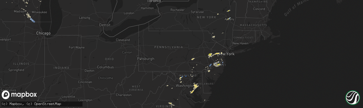
Hail Map in Pennsylvania on August 7, 2019
The weather event in Pennsylvania on August 7, 2019 includes Hail, Wind, and Tornado maps. 32 states and 948 cities were impacted and suffered possible damage. The total estimated number of properties impacted is 9,154.
Want more than just the map?
Turn this storm into a full workflow.
- Owner + property data so you know who to knock
- OnDemand branded weather history reports to win the "did we even have hail?" argument
- RoofTrace estimate so reps stop guessing numbers at the door
Bought this map? Upgrade within 7 days and we'll credit the $230. (10-15 min setup call)
Hail
Wind
Tornado
9,154
Estimated number of impacted properties by a 1.00" hail or larger0
Estimated number of impacted properties by a 1.75" hail or larger0
Estimated number of impacted properties by a 2.50" hail or largerStorm reports in Pennsylvania
Pennsylvania
| Date | Description |
|---|---|
| 08/07/20194:53 PM CDT | Tree down in wires on state rd. Time estimated from radar. |
| 08/07/20194:12 PM CDT | Downed tree blocking welsh road near inverness lane. Time estimated from radar. |
| 08/07/20194:02 PM CDT | Downed tree and power lines on hillcrest road. Time estimated from radar. |
| 08/07/20193:52 PM CDT | Downed tree blocking violet lane near periwinkle road. Time estimated from radar. |
| 08/07/20193:49 PM CDT | Downed power lines near the oreland station. Time estimated from radar. |
| 08/07/20193:38 PM CDT | Several trees and power lines down in the area. Time estimated from radar. |
| 08/07/20193:24 PM CDT | Social media video of large tree blown down damaging property at a residence. Time estimated from radar. |
| 08/07/20193:17 PM CDT | Downed trees on west river drive and lincoln drive. Time estimated from radar. |
| 08/07/20193:16 PM CDT | Downed tree on kelly drive. Time estimated from radar. |
| 08/07/20192:48 PM CDT | Mping report of trees uprooted or snapped. Time estimated from radar and nearby reports. |
| 08/07/20192:47 PM CDT | Large tree down near the intersection of meetinghouse road and delene road. Time estimated from radar. |
| 08/07/20192:47 PM CDT | Downed trees and wires reported. Time estimated from radar. |
| 08/07/20192:40 PM CDT | Multiple reports of trees down around bethlehem. Delayed report. |
| 08/07/20192:28 PM CDT | Downed tree on pond road. Time estimated from radar. |
| 08/07/20192:25 PM CDT | Tree into a house. Reports of wires down in the area. Time and location approximate. |
| 08/07/20192:18 PM CDT | Downed power lines affecting train service in the doylestown vicinity. Time and location approximate. |
| 08/07/20192:13 PM CDT | Downed trees and wires on unionville pike between bethlehem pike and north penn road. Time estimated from radar. |
| 08/07/20192:08 PM CDT | A tree fell and struck two moving vehicles on sumneytown pike eastbound west of kristin circle. |
| 08/07/20192:02 PM CDT | Downed wires on sumneytown pike near south broad street with road closures required. Time estimated from radar. |
| 08/07/20191:40 PM CDT | Delayed report. Significant damage in the area of 323 clayton ave in tilden twp. Numerous trees downed and the roof of an old barn removed. Local ema coordinator believ |
| 08/07/20191:40 PM CDT | Delayed report. Large tree down along with numerous limbs. Power lines also down in the roadway with one on fire. Time estimated from radar. |
| 08/07/20191:18 PM CDT | Downed tree struck two moving vehicles. |
| 08/07/20191:16 PM CDT | Downed tree on summer mountain road just east of zerbe road. Time estimated from radar. |
| 08/07/20191:07 PM CDT | Tree and wires down and power out in the area of parkside inn road. Time estimated from radar. |
| 08/07/201912:45 PM CDT | Trees down in swatara twp |
| 08/07/201912:27 PM CDT | Measured by the spotters personal weather station. Tree limbs up to seven inches in diameter down. |
| 08/07/20194:03 AM CDT | Large branches down |
| 08/07/201912:57 AM CDT | At 557 PM EDT, severe thunderstorms were located along a line extending from Clearbrook Park to near Mount Holly to Woodbury Heights, moving east at 30 mph. HAZARD...60 mph wind gusts and penny size hail. SOURCE...Radar indicated. IMPACT...Damage to roofs, siding, trees, and power lines is possible. Locations impacted include... Toms River, Trenton, Long Branch, Asbury Park, Gloucester City, Lakewood, Cherry Hill, Jackson, Howell, Evesham, Mount Laurel, Marlboro, Manalapan, Deptford, Voorhees, Medford, West Deptford, Tinton Falls, Lindenwold and Holmdel.This includes the following highways... Atlantic City Expressway between mile markers 43 and 44. Garden State Parkway between mile markers 70 and 113. Interstate 195 in New Jersey between mile markers 0 and 34. Interstate 295 in New Jersey between mile markers 18 and 67. |
| 08/06/201911:14 PM CDT | At 413 PM EDT, severe thunderstorms were located along a line extending from near Pen Argyl to near Bloomsbury, moving northeast at 30 mph. HAZARD...60 mph wind gusts and penny size hail. SOURCE...Radar indicated. IMPACT...Damage to roofs, siding, trees, and power lines is possible. Locations impacted include... Easton, Forks, East Stroudsburg, Hackettstown, Wilson, Washington, Blairstown, Bangor, Mendham, High Bridge, Pen Argyl, Wind Gap, Clinton, Belvidere, Harmony, Peapack And Gladstone, Oxford, Alpha, Hope and Glen Gardner.This includes Interstate 287 in New Jersey between mile markers 22and 26. |
| 08/06/201911:09 PM CDT | At 409 PM EDT, severe thunderstorms were located along a line extending from Princeton to Roxborough, moving northeast at 20 mph. HAZARD...60 mph wind gusts and penny size hail. SOURCE...Radar indicated. IMPACT...Damage to roofs, siding, trees, and power lines is possible. Locations impacted include... Philadelphia, Trenton, Camden, New Brunswick, Gloucester City, Somerset, Bensalem, East Brunswick, South Brunswick, Sayreville, North Brunswick, Ewing, Princeton, Yeadon, Burlington, Bristol, Riverside, Palmyra, Hatboro and Jenkintown.This includes the following highways... Garden State Parkway between mile markers 125 and 126. Interstate 195 in New Jersey between mile markers 0 and 1. Interstate 295 in New Jersey between mile markers 60 and 76. |
| 08/06/201910:54 PM CDT | At 354 PM EDT, severe thunderstorms were located along a line extending from near Frenchtown to near Pleasant Valley, moving north at 15 mph. HAZARD...60 mph wind gusts and penny size hail. SOURCE...Radar indicated. IMPACT...Damage to roofs, siding, trees, and power lines is possible. Locations impacted include... Easton, Quakertown, Washington, High Bridge, Clinton, Alpha, Glen Gardner, Ferndale, Hampton, Frenchtown, Milford, Califon, Bloomsbury, Riegelsville, Glendon, Revere, Pleasant Valley, Ottsville, Erwinna and Annandale. |
| 08/06/201910:38 PM CDT | At 338 PM EDT, a severe thunderstorm was located over Atsion, or 23 miles southeast of Gloucester City, moving north at 25 mph. HAZARD...60 mph wind gusts and nickel size hail. SOURCE...Radar indicated. IMPACT...Damage to roofs, siding, trees, and power lines is possible. Locations impacted include... Evesham, Willingboro, Medford, Hammonton, Lumberton, Burlington, Mount Holly, Berlin, Tabernacle, Shamong, Presidential Lakes Estates, Chesilhurst, Pemberton, Wrightstown, Atsion, Leisuretowne, Chatsworth, Jacksonville, Georgetown and Atco.This includes Interstate 295 in New Jersey between mile markers 42and 55. |
| 08/06/201910:24 PM CDT | At 324 PM EDT, a severe thunderstorm was located over Coffeetown, or near Allentown, moving northeast at 30 mph. HAZARD...60 mph wind gusts and quarter size hail. SOURCE...Radar indicated. IMPACT...Minor damage to vehicles is possible. Wind damage to roofs, siding, trees, and power lines is possible. Locations impacted include... Allentown, Easton, Bethlehem, Forks, Emmaus, Northampton, Wilson, Hellertown, Nazareth, Palmerton, Slatington, Pen Argyl, Wind Gap, Bath, Harmony, Alpha, Walnutport, Belfast, West Easton and Tatamy.People attending Musikfest should seek safe shelter immediately! |
| 08/06/201910:18 PM CDT | At 318 PM EDT, a severe thunderstorm was located over Fricks, or 21 miles southeast of Allentown, moving northeast at 35 mph. HAZARD...60 mph wind gusts and quarter size hail. SOURCE...Radar indicated. IMPACT...Minor damage to vehicles is possible. Wind damage to roofs, siding, trees, and power lines is possible. Locations impacted include... Perkasie, Doylestown, Byram, Bedminster, Chalfont, Tinicum, Dublin, Ferndale, Frenchtown, Milford, Riegelsville, Fricks, Revere, Ottsville, Pipersville, Erwinna, Gardenville, Lumberville, New Britain and Silverdale. |
| 08/06/20199:37 PM CDT | At 236 PM EDT, a severe thunderstorm was located over Taneytown, or 7 miles southeast of Emmitsburg, moving northeast at 20 mph. HAZARD...60 mph wind gusts and quarter size hail. SOURCE...Radar indicated. IMPACT...Damaging winds will cause some trees and large branches to fall. This could injure those outdoors, as well as damage homes and vehicles. Roadways may become blocked by downed trees. Localized power outages are possible. Unsecured light objects may become projectiles. Locations impacted include... Taneytown, Union Bridge, Harney, Linwood, Uniontown, Keysville and Keymar. |
| 08/06/20199:11 PM CDT | At 210 PM EDT, a severe thunderstorm was located over Fosterdale, or 14 miles east of Honesdale, moving northeast at 20 mph. HAZARD...60 mph wind gusts and quarter size hail. SOURCE...Radar indicated. IMPACT...Hail damage to vehicles is expected. Expect wind damage to roofs, siding, and trees. Locations impacted include... Fallsburg, Monticello, Liberty, Bethel, Neversink, South Fallsburg, Tusten, Cochecton, Woodridge and Jeffersonville. |
| 08/06/20198:46 PM CDT | At 146 PM EDT, a severe thunderstorm was located over Fredericksburg, or 9 miles northwest of Myerstown, moving northeast at 20 mph. HAZARD...60 mph wind gusts and penny size hail. SOURCE...Radar indicated. IMPACT...Damage to roofs, siding, trees, and power lines is possible. Locations impacted include... Hamburg, Shoemakersville, Strausstown and Centerport. |
| 08/06/20198:39 PM CDT | At 139 PM EDT, a severe thunderstorm was located over Fredericksburg, moving northeast at 30 mph. HAZARD...60 mph wind gusts and quarter size hail. SOURCE...Radar indicated. IMPACT...Hail damage to vehicles is expected. Expect wind damage to trees, roofs, and siding. Locations impacted include... Lebanon, Annville, Pleasant Hill, Sand Hill, Cleona, Avon, Fredericksburg, Lickdale, Fort Indiantown Gap, Jonestown and Ono.This includes the following Interstates... Interstate 78 from mile markers 0 to 8. Interstate 81 from mile markers 86 to 91. |
| 08/06/20198:26 PM CDT | At 125 PM EDT, a severe thunderstorm was located over Florence-Roebling, or 7 miles southwest of Trenton, moving northeast at 15 mph. HAZARD...60 mph wind gusts and half dollar size hail. SOURCE...Radar indicated. IMPACT...Minor damage to vehicles is possible. Wind damage to roofs, siding, trees, and power lines is possible. Locations impacted include... Trenton, Ewing, Florence, Burlington, Bristol, Bordentown, Pennington, Yardley, Tullytown, Allentown, Windsor, Florence-Roebling, Woodside, Edinburg, Crosswicks, White Horse, Mercerville-Hamilton Square, Levittown, Lawrenceville and Jacksonville.This includes the following highways... Interstate 195 in New Jersey between mile markers 0 and 8. Interstate 295 in New Jersey between mile markers 49 and 76. |
| 08/06/20198:22 PM CDT | At 121 PM EDT, severe thunderstorms were located along a line extending from near Califon to Frenchtown, moving northeast at 20 mph. HAZARD...60 mph wind gusts and penny size hail. SOURCE...Radar indicated. IMPACT...Damage to roofs, siding, trees, and power lines is possible. Locations impacted include... Dover, Boonton, Wharton, Rockaway, Mount Arlington, Mendham, Mountain Lakes, High Bridge, Stanhope, Netcong, Clinton, Peapack And Gladstone, Glen Gardner, Chester, Ferndale, Victory Gardens, Hampton, Frenchtown, Lebanon and Milford. |
All States Impacted by Hail Map on August 7, 2019
Cities Impacted by Hail Map on August 7, 2019
- Black Creek, WI
- Ballston Spa, NY
- Saratoga Springs, NY
- Greenfield Center, NY
- Rock City Falls, NY
- Gansevoort, NY
- Middle Grove, NY
- Mullica Hill, NJ
- Sewell, NJ
- Mantua, NJ
- Clarksboro, NJ
- Swedesboro, NJ
- Mickleton, NJ
- Woodstown, NJ
- White Hall, MD
- Gloucester, VA
- Wade, NC
- Moulton, AL
- Sturgeon Bay, WI
- Allen, KS
- Emporia, KS
- Crivitz, WI
- Cody, NE
- Wausaukee, WI
- White Lake, WI
- Pickerel, WI
- Elcho, WI
- Crandon, WI
- Pearson, WI
- Natoma, KS
- Plainville, KS
- Rice Lake, WI
- Weyerhaeuser, WI
- Bruce, WI
- Linn Creek, MO
- Stoutland, MO
- Montreal, MO
- Louisa, VA
- Palmyra, VA
- Kents Store, VA
- Goochland, VA
- Columbia, VA
- Matador, TX
- Paragould, AR
- Peach Orchard, AR
- Pocahontas, AR
- Maynard, AR
- Beech Grove, AR
- Biggers, AR
- Delaplaine, AR
- New Franken, WI
- Suamico, WI
- Luxemburg, WI
- Green Bay, WI
- Frederick, MD
- Ijamsville, MD
- Adamstown, MD
- Orchard, NE
- Page, NE
- Hawk Springs, WY
- Shaniko, OR
- Salina, KS
- Brookville, KS
- Baxter Springs, KS
- Quapaw, OK
- Stanton, TN
- Colome, SD
- Winner, SD
- New Egypt, NJ
- Cream Ridge, NJ
- Joffre, PA
- Burgettstown, PA
- Cheyenne Wells, CO
- Arapahoe, CO
- Green Lake, WI
- Ripon, WI
- Berlin, WI
- Naper, NE
- Black River Falls, WI
- Warrens, WI
- Pittsville, WI
- Delavan, WI
- Whitewater, WI
- Burlington, CO
- Disputanta, VA
- Spring Grove, VA
- Waverly, VA
- Courtland, VA
- Capron, VA
- Claude, TX
- Huntsville, AL
- Harvest, AL
- Pocahontas, TN
- Selmer, TN
- Emporia, VA
- Gladstone, NJ
- Califon, NJ
- Far Hills, NJ
- Hazel Green, AL
- Manistique, MI
- Cooks, MI
- Bryant, WI
- Merrillan, WI
- Keiser, AR
- Folkston, GA
- Carpenter, WY
- Hornbeak, TN
- Eureka, KS
- Hamilton, KS
- Fredonia, KS
- Benedict, KS
- Sheridan Lake, CO
- Tribune, KS
- Warm Springs, AR
- Cornersville, TN
- Lynnville, TN
- Culleoka, TN
- Yorktown, VA
- Arnett, OK
- Durham, OK
- Kimberly, WI
- Little Chute, WI
- Combined Locks, WI
- Appleton, WI
- Kaukauna, WI
- Sherwood, MD
- Cordova, MD
- Saint Michaels, MD
- Royal Oak, MD
- Chester, MD
- Tilghman, MD
- Prince Frederick, MD
- Wittman, MD
- Saint Leonard, MD
- Port Republic, MD
- Easton, MD
- Mcdaniel, MD
- Bozman, MD
- Queenstown, MD
- Neavitt, MD
- Stevensville, MD
- Grasonville, MD
- Claiborne, MD
- Wiggins, CO
- Marengo, WI
- Mellen, WI
- Glidden, WI
- Clam Lake, WI
- Seymour, WI
- Hortonville, WI
- New London, WI
- Watervliet, NY
- Albany, NY
- Delmar, NY
- Slingerlands, NY
- Troy, NY
- Roscoe, NY
- Blounts Creek, NC
- Washington, NC
- Bath, NC
- Ward, AR
- Lonoke, AR
- Tescott, KS
- Beverly, KS
- Lincoln, KS
- Grand Junction, TN
- Saulsbury, TN
- Lagrange, WY
- Brodnax, VA
- Paris, AR
- Tigerton, WI
- Henning, TN
- Ripley, TN
- Happy, TX
- Gypsum, KS
- Newport, NE
- Wheatland, WY
- Thayer, KS
- Fall River, KS
- Altoona, KS
- Longton, KS
- Liberty, KS
- Mound Valley, KS
- Dennis, KS
- Cherryvale, KS
- Neodesha, KS
- Independence, KS
- Toronto, KS
- Red House, VA
- Brookneal, VA
- Burke, SD
- Coleman, WI
- Pound, WI
- Brussels, WI
- Lena, WI
- Oconto, WI
- Peshtigo, WI
- Humboldt, KS
- Iola, KS
- Elsmore, KS
- Chanute, KS
- Erie, KS
- Piqua, KS
- Savonburg, KS
- Moran, KS
- Yates Center, KS
- La Harpe, KS
- Mission, SD
- Platte, SD
- Easton, PA
- Cochecton, NY
- Bethel, NY
- Swan Lake, NY
- Narrowsburg, NY
- White Lake, NY
- Edgar, WI
- Mosinee, WI
- Tarboro, NC
- Rocky Mount, NC
- Altus, AR
- Ozark, AR
- Magazine, AR
- New Bern, NC
- Ernul, NC
- Neshkoro, WI
- Brush, CO
- Snyder, CO
- Hillrose, CO
- Spencer, WI
- Brillion, WI
- Potter, WI
- Hilbert, WI
- Chilton, WI
- Blairstown, MO
- Bassett, NE
- Woodston, KS
- Roland, AR
- Short Hills, NJ
- Livingston, NJ
- West Orange, NJ
- Millburn, NJ
- Harrison, SD
- Armour, SD
- Corsica, SD
- Dallas, SD
- Mills, NE
- Gregory, SD
- Assaria, KS
- Lindsborg, KS
- Falun, KS
- Maupin, OR
- Marshall, AR
- Winneconne, WI
- Omro, WI
- Fremont, WI
- Powhatan, VA
- Brandon, WI
- Agate, CO
- Stuart, NE
- Atkinson, NE
- Taylor, WI
- Cherokee, AL
- Marion, KS
- Phillipsburg, NJ
- Bloomsbury, NJ
- Myerstown, PA
- Fredericksburg, PA
- Annville, PA
- Lebanon, PA
- Jonestown, PA
- Paradise, KS
- Oshkosh, WI
- Kilgore, NE
- Nenzel, NE
- Joint Base Mdl, NJ
- Wrightstown, NJ
- Allentown, NJ
- Chesterfield, NJ
- Jonesboro, AR
- Jefferson, WI
- Stover, MO
- Cole Camp, MO
- Dover, AR
- Geddes, SD
- Morrisville, PA
- Florence, NJ
- Bristol, PA
- Reno, NV
- Asbury, NJ
- Stewartsville, NJ
- Matfield Green, KS
- Sunrise Beach, MO
- Halifax, NC
- Belhaven, NC
- Hackett, AR
- Adams, WI
- Grand Marsh, WI
- Oxford, WI
- Westfield, WI
- Lenora, KS
- Clayton, KS
- Chugwater, WY
- Columbus, WI
- Reeseville, WI
- Beaver Dam, WI
- Ellington, MO
- McMillan, MI
- Alcester, SD
- Centerville, KS
- Mound City, KS
- Laona, WI
- Argonne, WI
- Fairwater, WI
- Redgranite, WI
- Fox Lake, WI
- Dresden, KS
- Amagon, AR
- Fisher, AR
- Vinemont, AL
- Falkville, AL
- Crookston, NE
- Valentine, NE
- Sanford, NC
- Summit, NJ
- Springfield, NJ
- Maplewood, NJ
- Grass Valley, OR
- Kent, OR
- Centerview, MO
- Warrensburg, MO
- Drummonds, TN
- Wilson, AR
- Osceola, AR
- Covington, TN
- Burlison, TN
- Quartzsite, AZ
- Springview, NE
- Le Roy, KS
- Colony, KS
- Waverly, KS
- Burlington, KS
- Neosho Falls, KS
- Westphalia, KS
- Lebo, KS
- Newport, AR
- Palatine Bridge, NY
- Fort Plain, NY
- Canajoharie, NY
- Dundee, MS
- Tunica, MS
- Elkhorn, WI
- Coldwater, KS
- Tyndall, SD
- Dinwiddie, VA
- Petersburg, VA
- Utica, SD
- Menno, SD
- Jarrettsville, MD
- Street, MD
- Raleigh, NC
- Cary, NC
- Apex, NC
- Virgil, KS
- Arriba, CO
- Admire, KS
- Reading, KS
- Americus, KS
- Watkinsville, GA
- Inman, KS
- Pocomoke City, MD
- Oberlin, KS
- Selden, KS
- Protection, KS
- Tampa, KS
- Durham, KS
- Irene, SD
- Lesterville, SD
- Nevada, MO
- Richards, MO
- Howard, KS
- Toney, AL
- Leola, PA
- Ronks, PA
- Bird In Hand, PA
- Waldo, KS
- Luray, KS
- Barnard, KS
- Sylvan Grove, KS
- Lucas, KS
- Alton, KS
- Hunter, KS
- Sterling, VA
- Potomac, MD
- Poolesville, MD
- Gaithersburg, MD
- Germantown, MD
- Haven, KS
- Hutchinson, KS
- Friendship, WI
- Coloma, WI
- Reedsville, WI
- Cheyenne, WY
- Fort Morgan, CO
- Everton, AR
- Saint Joe, AR
- Snow Hill, NC
- Hookerton, NC
- Limon, CO
- Pleasanton, KS
- Columbus, KS
- Galena, KS
- Riverton, KS
- Crossett, AR
- Lebanon, MO
- Richland, MO
- Brumley, MO
- Whitelaw, WI
- Maribel, WI
- Wray, CO
- Bogue, KS
- Blue Mound, KS
- Tuthill, SD
- Martin, SD
- Cedar Point, KS
- Sun Prairie, WI
- Cambria, WI
- Randolph, WI
- Walker, MO
- Sulphur Rock, AR
- Bloomfield, NE
- Witten, SD
- Obion, TN
- Troy, TN
- Canyon, TX
- Mount Calvary, WI
- Malone, WI
- Fond Du Lac, WI
- Seaford, VA
- Albertson, NC
- Pink Hill, NC
- Kinston, NC
- Trenton, NC
- Dover, NC
- Menasha, WI
- Preston, MD
- Sparks, NV
- Genoa, CO
- Windsor, VA
- Smithfield, VA
- Springfield, SD
- Avon, SD
- Tripp, SD
- Niobrara, NE
- Marianna, AR
- Marion, WI
- Clintonville, WI
- Mountain View, AR
- Carlisle, AR
- Taft, TN
- Fayetteville, TN
- Briggsdale, CO
- Neal, KS
- Algoma, WI
- Casco, WI
- Columbia, TN
- Needles, CA
- Coffeyville, KS
- Cassoday, KS
- Stratford, WI
- Jarratt, VA
- Sedley, VA
- Wabeno, WI
- Vona, CO
- Licking, MO
- Williamsburg, VA
- Emmet, NE
- Oneill, NE
- Athelstane, WI
- Shiocton, WI
- Chili, WI
- Marshfield, WI
- Hillsboro, WI
- Eldred, NY
- La Cygne, KS
- Godwin, NC
- Saint Francis, SD
- Pemberton, NJ
- Jackson, NJ
- Jobstown, NJ
- Columbus, NJ
- Manawa, WI
- Kanorado, KS
- Babcock, WI
- Byers, CO
- Suffolk, VA
- Clayton, NC
- Manchester, TN
- Ellinwood, KS
- Cherry Valley, AR
- Bernardsville, NJ
- Basking Ridge, NJ
- Germfask, MI
- Eleva, WI
- Bluffton, SC
- Lyndon, KS
- Clinton, MO
- Batesville, AR
- Lillington, NC
- Bloomfield, NJ
- Dickerson, MD
- Monrovia, MD
- Bluejacket, OK
- Okatie, SC
- Athens, WI
- Mullinville, KS
- Delmont, SD
- Iuka, MS
- Burnsville, MS
- Fort Leavenworth, KS
- Weiner, AR
- Witts Springs, AR
- Hector, AR
- Toone, TN
- Whiteville, TN
- Bolivar, TN
- Austin, AR
- Bulger, PA
- Buhler, KS
- Autryville, NC
- Roseboro, NC
- Salemburg, NC
- Junction City, WI
- De Pere, WI
- Newark, NJ
- Warren, NJ
- Martinsville, NJ
- Bridgewater, NJ
- Somerville, NJ
- Centerville, TN
- Glen, MS
- Russellville, AL
- Larsen, WI
- Oil Trough, AR
- Dellrose, TN
- Quakertown, PA
- Kintnersville, PA
- Cash, AR
- Rogersville, AL
- Anderson, AL
- Elkmont, AL
- Athens, AL
- Atwood, KS
- Gravois Mills, MO
- Manassas, VA
- Centreville, VA
- Loyal, WI
- Granton, WI
- Neillsville, WI
- Cedar Grove, TN
- Parmelee, SD
- Millington, TN
- Pleasant Grove, AR
- Marcella, AR
- Sedgwick, KS
- Madison, AL
- Aulander, NC
- Windsor, NC
- Norfolk, VA
- Alta Vista, KS
- Eskridge, KS
- Alma, KS
- Bear Creek, WI
- Des Arc, AR
- Hebron, IL
- Harvard, IL
- Virginia Beach, VA
- Chesapeake, VA
- Portsmouth, VA
- Lake Geneva, WI
- Genoa City, WI
- Westerville, OH
- Galena, OH
- Garnet Valley, PA
- Wilmington, DE
- Chadds Ford, PA
- Goodman, MO
- Seneca, MO
- Neosho, MO
- Newark, AR
- Lowland, NC
- Waterloo, AL
- Townsend, WI
- Lakewood, WI
- Pollocksville, NC
- Gleason, WI
- Yoder, WY
- Lawrenceville, VA
- La Crosse, VA
- White Plains, VA
- Ebony, VA
- Little Rock, AR
- Fontana, KS
- Edna, KS
- Elk City, KS
- Buffalo, KS
- Caroline, WI
- Dyer, TN
- Manila, AR
- Osseo, WI
- Fort Atkinson, WI
- Marlboro, NJ
- Morganville, NJ
- Englishtown, NJ
- Front Royal, VA
- Fort Valley, VA
- Bentonville, VA
- Bellvue, CO
- Loveland, CO
- Maysville, NC
- Woodville, AL
- Paint Rock, AL
- Kimball, SD
- Saint Paul, KS
- Aurora, NC
- Parkston, SD
- New Holland, SD
- Greenwood, WI
- Markesan, WI
- Princeton, WI
- Catharine, KS
- Leavenworth, KS
- Kansas City, KS
- Enid, OK
- Defuniak Springs, FL
- Daufuskie Island, SC
- Greenville, WI
- Doniphan, MO
- Fremont, MO
- Long Valley, NJ
- Lebanon, NJ
- Ettrick, WI
- Eads, CO
- Wautoma, WI
- Uniontown, KS
- Williamsport, TN
- Rhinelander, WI
- Amherst Junction, WI
- Scandinavia, WI
- Iola, WI
- Ogdensburg, WI
- Cockeysville, MD
- Phoenix, MD
- Broomall, PA
- Media, PA
- Newtown Square, PA
- Springfield, PA
- Battleboro, NC
- Nichols, WI
- Pulaski, WI
- Bonduel, WI
- Florence, AL
- Plymouth, WI
- Waldo, WI
- Sheboygan Falls, WI
- Minneola, KS
- Drewryville, VA
- Florham Park, NJ
- South Orange, NJ
- Chatham, NJ
- Union, NJ
- Vauxhall, NJ
- Forestville, WI
- Crum Lynne, PA
- Woodlyn, PA
- Ridley Park, PA
- Deer Trail, CO
- Prescott, KS
- Morristown, NJ
- Chester, NJ
- New Vernon, NJ
- Peapack, NJ
- Mauston, WI
- Reedsburg, WI
- Baraboo, WI
- Perkasie, PA
- Howard, OH
- Walhonding, OH
- Cottonwood Falls, KS
- Cove City, NC
- Waterloo, WI
- Lake Mills, WI
- Lake City, AR
- Brookland, AR
- Mountain, WI
- Langhorne, PA
- Levittown, PA
- Fairless Hills, PA
- Mason, TN
- Arlington, TN
- Edgerton, WI
- Dendron, VA
- Welch, OK
- Bartlett, KS
- Valley Springs, AR
- Yellville, AR
- Duck River, TN
- Sharon, CT
- Fuquay Varina, NC
- Pachuta, MS
- Burrton, KS
- Kit Carson, CO
- Belle Plaine, KS
- Wellington, KS
- Altamont, KS
- Oswego, KS
- Charles City, VA
- Providence Forge, VA
- Hixton, WI
- Alma Center, WI
- Abilene, KS
- Paola, KS
- Alicia, AR
- Hoxie, AR
- Grifton, NC
- Memphis, TN
- Kansas City, MO
- Riegelsville, PA
- Milford, NJ
- Washington, NJ
- Arpin, WI
- Necedah, WI
- Boydton, VA
- Denmark, WI
- Kewaunee, WI
- Stone Ridge, NY
- Accord, NY
- New Park, PA
- Felton, PA
- Airville, PA
- Locust Grove, AR
- Thorp, WI
- Kiel, WI
- New Holstein, WI
- Hermitage, AR
- Saint Francis, KS
- Shawano, WI
- Lake Ozark, MO
- Holly, CO
- Dunn, NC
- Hardeeville, SC
- Burlington, NC
- Haw River, NC
- Arcadia, WI
- Mount Olive, NC
- Mongaup Valley, NY
- Knobel, AR
- Lafe, AR
- Stickney, SD
- Manitowoc, WI
- Chetopa, KS
- Windsor, NJ
- Hightstown, NJ
- Robbinsville, NJ
- Bordentown, NJ
- Mount Holly, NJ
- Beverly, NJ
- Lakehurst, NJ
- Trenton, NJ
- Bensalem, PA
- Browns Mills, NJ
- Vincentown, NJ
- Cookstown, NJ
- Burlington, NJ
- Croydon, PA
- Parsons, KS
- McCune, KS
- Carthage, NC
- Van Dyne, WI
- Gatewood, MO
- Butte, NE
- Pittstown, NJ
- Annandale, NJ
- Helena, AR
- Weldona, CO
- Saint Paul, AR
- New Hill, NC
- Hartington, NE
- Scotland, SD
- Wausa, NE
- Wagner, SD
- Waupun, WI
- Pleasant City, OH
- Kent, OH
- Oviedo, FL
- Ono, PA
- Shell Knob, MO
- Berryville, AR
- Sandy Hook, VA
- Maidens, VA
- Windsor, MO
- Wetmore, MI
- Rapid River, MI
- Feura Bush, NY
- Amissville, VA
- Marshall, VA
- Rosalia, KS
- Severy, KS
- Piedmont, KS
- Brownsville, TN
- Oakland, TN
- Rossville, TN
- Old Bridge, NJ
- Matawan, NJ
- Hudson, SD
- Huntingtown, MD
- Valley Center, KS
- Pelican Lake, WI
- Halstead, KS
- Okreek, SD
- Wood, SD
- Oconto Falls, WI
- Suring, WI
- Lewisburg, TN
- Walnut Ridge, AR
- Ayden, NC
- Princeton, NJ
- Monmouth Junction, NJ
- Kingston, NJ
- Monette, AR
- Wittenberg, WI
- Madison, KS
- Tanner, AL
- Rosebud, SD
- Norris, SD
- Conestoga, PA
- Elkhart Lake, WI
- Saint Cloud, WI
- Mount Judea, AR
- Mason, WI
- Mays Landing, NJ
- Hayes, VA
- Faison, NC
- Stokes, NC
- Greenville, NC
- Hilliard, FL
- Oneida, WI
- Rosendale, WI
- Eldorado, WI
- Pickett, WI
- Senecaville, OH
- Spring Hill, TN
- Waynesville, MO
- Coats, NC
- Hattiesburg, MS
- Penokee, KS
- Cleveland, WI
- Newton, WI
- Savannah, GA
- Morland, KS
- Green Village, NJ
- Eland, WI
- Goodland, KS
- Annapolis, MD
- Crosbyton, TX
- Ottsville, PA
- Upper Black Eddy, PA
- Bethlehem, PA
- Bedminster, NJ
- High Bridge, NJ
- Frenchtown, NJ
- Hampton, NJ
- Clinton, NJ
- Hellertown, PA
- Mendham, NJ
- Conway, NC
- Murfreesboro, NC
- Vossburg, MS
- Conrath, WI
- Glen Arm, MD
- Nottingham, MD
- Perry Hall, MD
- Parkville, MD
- Boyds, MD
- Clarksburg, MD
- Barnesville, MD
- Cedarburg, WI
- Lansdowne, PA
- Cordova, TN
- Mount Pleasant, SC
- Phenix, VA
- Willard, WI
- Lawrence Township, NJ
- Glen Mills, PA
- Spotsylvania, VA
- Stedman, NC
- East Brunswick, NJ
- Lewiston Woodville, NC
- Kelford, NC
- Oostburg, WI
- Cedar Grove, WI
- Knob Noster, MO
- Ionia, MO
- Hartford, KS
- Stony Creek, VA
- Flintville, TN
- Marshall, WI
- Rector, AR
- Munising, MI
- Arkdale, WI
- Valders, WI
- Hopewell, VA
- Cumberland, OH
- Susan, VA
- Willow Spring, NC
- Guion, AR
- Melbourne, AR
- New Market, AL
- Appomattox, VA
- Clarendon, TX
- Unity, WI
- Hewitt, WI
- Richmond, IL
- Twin Lakes, WI
- Burlington, WI
- Spring Grove, IL
- Williams Bay, WI
- Bryn Athyn, PA
- Bala Cynwyd, PA
- Huntingdon Valley, PA
- Elkins Park, PA
- Jenkintown, PA
- Abington, PA
- Cheltenham, PA
- Philadelphia, PA
- Wyncote, PA
- Glenside, PA
- Easthampton, MA
- Southampton, MA
- Howell, NJ
- Freehold, NJ
- Farmingdale, NJ
- Lakewood, NJ
- Sykesville, MD
- Mount Airy, MD
- New Market, MD
- Crofton, NE
- Tabor, SD
- Rensselaer, NY


