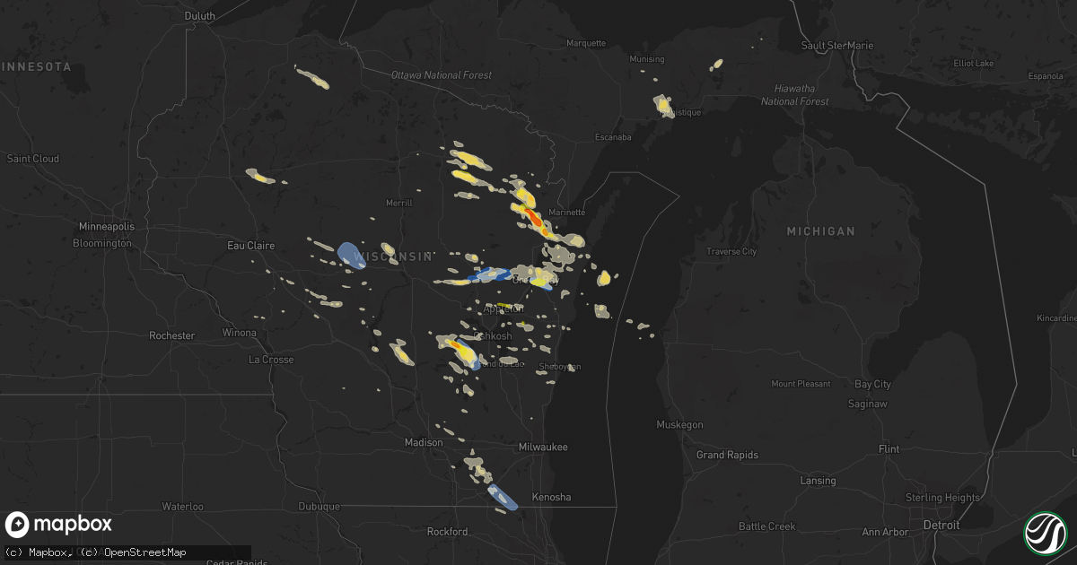
Hail Map on August 7, 2019
Get this storm
August 7 map
$229
one time, instant access
Download today. No call, no setup
Keep the $229
Bought the map and want the full workflow? Apply the entire $229 to a subscription within 7 days. None of it is wasted.
Every map, not just this one
This buys you this map. Subscription and you get every map we run, in the markets you choose from a few cities to whole states to nationwide. Plus real-time alerts the moment a storm fires.
Contact data
Name, contact info, occupancy, even credit band for addresses in the footprint. You go from where it hit to who to call.
Become the source they trust
Unlimited branding weather history reports on demand. You already have the documented answer ready for the property owner, and you are the one who showed up with it.
Property data and RoofTrace estimates
Pull up any address you have got, its value and the exact code rules for that jurisdiction, straight from One Click Code. Then RoofTrace estimates the squares, pitch, and roof value, priced the way you price.
States Impacted by Hail Map on August 7, 2019
Storm reports
South Carolina
| Date | Description |
|---|---|
| 08/07/20195:10 PM CDT | A trained spotter reported quarter sized hail. |
| 08/07/201912:46 AM CDT | At 546 PM EDT, a severe thunderstorm was located over Bluffton, moving east at 10 mph. HAZARD...60 mph wind gusts and quarter size hail. SOURCE...Radar indicated. IMPACT...Minor hail damage to vehicles is possible. Expect wind damage to trees and powerlines. Locations impacted include... Hilton Head Island, Bluffton, Calawassie Island, Hilton Head Airport, Forest Beach, Rose Hill, Folly Field and Parris Island. |
New York
| Date | Description |
|---|---|
| 08/07/20195:10 PM CDT | Tree limbs down on route 50. |
| 08/07/20195:07 PM CDT | A local report indicates 1.00 inch wind near 2 N SARATOGA SPRINGS |
| 08/07/20195:07 PM CDT | Large tree limb down on maple ave |
| 08/07/20195:05 PM CDT | Medium size tree down on north broadway |
| 08/07/20194:22 PM CDT | Large tree down |
| 08/07/20193:56 PM CDT | Tree down on mcdonald drive blocking the roadway |
| 08/07/20193:43 PM CDT | Tree down in the roadway on klein road near doodletown road |
| 08/07/20193:42 PM CDT | Tree down on powerlines on county route 11 off of state route 82 in the town of taghkanic |
| 08/07/20193:34 PM CDT | Trees down |
| 08/07/20193:28 PM CDT | Tree down on wires |
| 08/07/20193:25 PM CDT | Tree and wires down on route 32 |
| 08/07/20193:17 PM CDT | Trees down in town of palentine. |
| 08/07/20193:14 PM CDT | Trees down |
| 08/07/20193:13 PM CDT | Wires down on an unoccupied vehicle on delaware avenue in glasco |
| 08/07/20193:10 PM CDT | Power lines down on lillie road in the town of caanan |
| 08/07/20192:58 PM CDT | Multiple trees down route 55 near airport rd. |
| 08/07/20192:58 PM CDT | Tree down in the roadway on route 203 just west of route 22 |
| 08/07/20192:55 PM CDT | Tree down on rigor hill road near pratt hill road |
| 08/07/20192:54 PM CDT | Wires down on a vehicle at hurley mountain road and dug hill road |
| 08/07/20192:50 PM CDT | Tree down on hunt road near county route 21 |
| 08/07/20192:43 PM CDT | Tree down on county route 7. |
| 08/07/20192:43 PM CDT | Tree and wires down on van wagenen lane |
| 08/07/20192:43 PM CDT | Tree and wires down on atwood road |
| 08/07/20192:42 PM CDT | Tree and wires down on an occupied vehicle on atwood road |
| 08/07/20192:40 PM CDT | Tree and wires down on buck road |
| 08/07/20192:26 PM CDT | Tree down on county route 7. |
| 08/07/20192:19 PM CDT | Wires down near 394 route 17b. |
| 08/07/20191:46 PM CDT | Tree down on wires in the town of clinton |
| 08/07/20191:43 PM CDT | Tree down on a roof of a house near 54 plank road. |
| 08/07/20191:43 PM CDT | Trees and wires down on crumley vab vactor road... Between fraser road and gale road. |
| 08/07/20191:41 PM CDT | Trees and wires down blocking the roadway near 775 lt j g brender highway. |
| 08/07/20191:39 PM CDT | Multiple trees and wires down near 4028 state route 55 near camp toras. Buildings damaged as well. |
| 08/07/20191:34 PM CDT | Tree down on a porch |
| 08/07/20191:11 PM CDT | Route 2 closed between south lake avenue and west avenue due to downed wires |
| 08/07/20191:10 PM CDT | Tree down on sheldon avenue |
| 08/07/20191:09 PM CDT | Tree snapped and fell on a car on 3rd st in downtown troy |
| 08/07/20191:08 PM CDT | Two large trees snapped and numerous large branches down in and around the griswold heights apartment complex. Fire department has blocked off the area. |
| 08/07/20191:06 PM CDT | Quarter size hail on 6th ave |
| 08/07/20191:06 PM CDT | Two medium to large trees down on campbell ave near thomas street in troy |
| 08/07/20191:05 PM CDT | A local report indicates 1.00 inch wind near 2 S TROY |
| 08/07/20191:05 PM CDT | Several trees down on the east side of troy especially in the vicinity of pawling and campbell. One tree down on a vehicle. |
| 08/07/20191:04 PM CDT | Several large branches down on mill street near burden ave in troy |
| 08/07/20191:00 PM CDT | Tree down blocking the shoulder and right lane of interstate 787 |
| 08/07/201912:56 PM CDT | Tree down on water street near columbia street in downtown albany |
| 08/07/20192:04 AM CDT | At 704 PM EDT, a severe thunderstorm was located over Addison, moving northeast at 25 mph. HAZARD...60 mph wind gusts and quarter size hail. SOURCE...Radar indicated. IMPACT...Minor hail damage to vehicles is possible. Expect wind damage to trees and powerlines. Locations impacted include... South Burlington, Vergennes, Burlington, Middlebury, Essex, Willsboro, Westport, Weybridge, Monkton Ridge, Waterbury Village, Monkton, Monkton Boro, Williston, New Haven, Addison, Hinesburg, St. George, Starksboro, Shelburne and Ferrisburg. |
| 08/07/20191:05 AM CDT | At 605 PM EDT, a severe thunderstorm was located over Jamaica, moving east at 30 mph. HAZARD...60 mph wind gusts. SOURCE...Radar indicated. IMPACT...Expect damage to trees and power lines. This severe thunderstorm will be near... Throgs Neck Bridge and Cedarhurst around 610 PM EDT. Valley Stream and Woodmere around 615 PM EDT. Lynbrook and Great Neck around 620 PM EDT. Garden City and Mineola around 625 PM EDT. Freeport around 630 PM EDT. Westbury and Brookville around 635 PM EDT. Levittown and Hicksville around 640 PM EDT. Plainview and Massapequa around 645 PM EDT. |
| 08/07/20191:03 AM CDT | At 603 PM EDT, a severe thunderstorm was located near Saratoga Springs, moving east at 20 mph. HAZARD...60 mph wind gusts and quarter size hail. SOURCE...Radar indicated. IMPACT...Hail damage to vehicles is expected. Expect wind damage to roofs, siding, and trees. Locations impacted include... Saratoga Springs, Hudson Falls, Salem, Fort Edward, Hartford, Greenwich, Kings, Gates, Wilton, Greenfield, Northumberland, South Glens Falls, Schuylerville, Victory, Argyle, Deans Corners, Cossayuna, Dunham Basin, Center Falls and Goose Island. |
| 08/07/201912:02 AM CDT | At 501 PM EDT, severe thunderstorms were located along a line extending from near Tottenville to near Rocky Hill, moving northeast at 20 mph. HAZARD...60 mph wind gusts and penny size hail. SOURCE...Radar indicated. IMPACT...Damage to roofs, siding, trees, and power lines is possible. Locations impacted include... New Brunswick, Perth Amboy, Somerville, Somerset, Edison, Old Bridge, East Brunswick, South Brunswick, Sayreville, North Brunswick, Carteret, Middlesex, Princeton, Bound Brook, Manville, Keansburg, Matawan, Rocky Hill, Millstone and Brownville.This includes the following highways... Garden State Parkway between mile markers 118 and 133. Interstate 287 in New Jersey between mile markers 0 and 19. |
| 08/06/201911:42 PM CDT | At 442 PM EDT, a severe thunderstorm was located near Tribes Hill, or near Fonda, moving east at 30 mph. HAZARD...70 mph wind gusts and penny size hail. SOURCE...Radar indicated. IMPACT...Expect considerable tree damage. Damage is likely to mobile homes, roofs, and outbuildings. Locations impacted include... Schenectady, Amsterdam, Johnstown, Scotia, Fonda, Glenville, Niskayuna, Hagaman, Fort Johnson, Galway, Rotterdam Junction, East Glenville, Tribes Hill, Alplaus, Pattersonville-Rotterdam Junction, Charlton, Perth, Glen, Charleston and Fultonville. |
| 08/06/201911:34 PM CDT | At 434 PM EDT, a severe thunderstorm was located over Twin Rivers, or 13 miles south of New Brunswick, moving northeast at 30 mph. HAZARD...60 mph wind gusts and penny size hail. SOURCE...Radar indicated. IMPACT...Damage to roofs, siding, trees, and power lines is possible. Locations impacted include... New Brunswick, Perth Amboy, Edison, Old Bridge, East Brunswick, Sayreville, North Brunswick, Manalapan, Carteret, Keansburg, Matawan, Jamesburg, Hightstown, Cranbury, Roosevelt, Colonia, Brownville, Dayton, Robertsville and North Brunswick Township.This includes the following highways... Garden State Parkway between mile markers 117 and 134. Interstate 195 in New Jersey between mile markers 15 and 16. Interstate 287 in New Jersey between mile markers 0 and 4. |
| 08/06/201911:22 PM CDT | At 422 PM EDT, a severe thunderstorm was located over Wells, or 15 miles south of Speculator, moving east at 20 mph. HAZARD...60 mph wind gusts and quarter size hail. SOURCE...Radar indicated. IMPACT...Hail damage to vehicles is expected. Expect wind damage to roofs, siding, and trees. Locations impacted include... Lake Pleasant, Wells, Sacandaga Campground, Harrisburg, Hope, Gilmantown, Girards Sugarbush, Hope Falls, Griffin, Blackbridge and Bakertown. |
| 08/06/201911:16 PM CDT | At 415 PM EDT, a severe thunderstorm was located over Canajoharie, moving northeast at 30 mph. HAZARD...60 mph wind gusts and quarter size hail. SOURCE...Radar indicated. IMPACT...Hail damage to vehicles is expected. Expect wind damage to roofs, siding, and trees. Locations impacted include... Amsterdam, Gloversville, Johnstown, Canajoharie, Fonda, Fort Plain, Ephratah, Broadalbin, Hagaman, Mayfield, Fort Johnson, Ames, Tribes Hill, Cranberry Creek, Caroga Lake Public Campground, Northampton Beach Public Campground, Perth, Glen, Berkshire and Fultonville. |
| 08/06/201910:59 PM CDT | At 359 PM EDT, a severe thunderstorm was located over Brownville, or 7 miles south of Perth Amboy, moving northeast at 20 mph. HAZARD...60 mph wind gusts and penny size hail. SOURCE...Radar indicated. IMPACT...Damage to roofs, siding, trees, and power lines is possible. Locations impacted include... Perth Amboy, Old Bridge, East Brunswick, Sayreville, Carteret, Keansburg, Matawan, Jamesburg, Brownville, Robertsville, Clearbrook Park, Yorketown, Whittingham, Morganville, Woodbridge, South River, Spotswood, Keyport, Helmetta and Englishtown.This includes Garden State Parkway between mile markers 115 and 130. |
| 08/06/201910:52 PM CDT | At 352 PM EDT, a severe thunderstorm was located over Hurley, or near Kingston, moving northeast at 25 mph. HAZARD...60 mph wind gusts and penny size hail. SOURCE...Radar indicated. IMPACT...Expect damage to roofs, siding, and trees. Locations impacted include... Kingston, Saugerties, Rhinebeck, Hurley, Woodstock, Clermont, Red Hook, High Falls, Tillson, West Hurley, Saugerties South, Port Ewen, Lake Katrine, Olivebridge, Rosendale, Marbletown, Veteran, Germantown, Tivoli and Centerville. |
| 08/06/201910:46 PM CDT | At 346 PM EDT, a severe thunderstorm was located over Canajoharie, moving northeast at 20 mph. HAZARD...60 mph wind gusts and quarter size hail. SOURCE...Radar indicated. IMPACT...Hail damage to vehicles is expected. Expect wind damage to roofs, siding, and trees. Locations impacted include... Gloversville, Johnstown, Canajoharie, Fonda, Fort Plain, St. Johnsville, Ephratah, Fort Johnson, Ames, Tribes Hill, Glen, Fultonville, Palatine Bridge, Nelliston, Meco, Cook Corners, Church Corners, Hale Mills, McKinley and Square Barn Corners. |
| 08/06/201910:37 PM CDT | At 337 PM EDT, a severe thunderstorm was located near Battle Island State Park, or 7 miles northeast of Fulton, moving northeast at 15 mph. HAZARD...60 mph wind gusts. SOURCE...Radar indicated. IMPACT...Expect damage to roofs, siding, and trees. Locations impacted include... Pulaski, Selkirk Shores State Park, Mexico Point State Park, Hastings, Palermo, New Haven, Mexico, Parish, Port Ontario and Howardville. This includes Interstate 81 between exits 33 and 36. |
| 08/06/201910:35 PM CDT | At 335 PM EDT, a severe thunderstorm was located over Kerhonkson, or near Ellenville, moving northeast at 15 mph. HAZARD...60 mph wind gusts and penny size hail. SOURCE...Radar indicated. IMPACT...Expect damage to roofs, siding, and trees. Locations impacted include... Ellenville, Tillson, Kerhonkson, Napanoch, Wawarsing, Rosendale, Marbletown, Port Ben, Cherrytown, Lefever Falls, Maple Hill, Atwood, Liebhardt, Fantinekill, Alligerville, Lake Minnewaska, Stone Ridge, Granite, Mombaccus and Honk Hill. |
| 08/06/201910:21 PM CDT | At 321 PM EDT, a severe thunderstorm was located near Napanoch, or 10 miles north of Ellenville, moving northeast at 30 mph. HAZARD...60 mph wind gusts and penny size hail. SOURCE...Radar indicated. IMPACT...Expect damage to roofs, siding, and trees. Locations impacted include... Kingston, Hurley, Woodstock, West Shokan, Kenneth L Wilson Campground, West Hurley, Olivebridge, Cherrytown, Rolling Meadows, Glenford, Palentown, Atwood, Sweet Meadows, Pacama, Brodhead, Liebhardt, Hillside, Zena, Morgan Hill and Mombaccus. |
| 08/06/20199:30 PM CDT | At 230 PM EDT, severe thunderstorms were located along a line extending from Edison to Old Bridge, moving east at 25 mph. HAZARD...70 mph wind gusts and penny size hail. SOURCE...Radar indicated. IMPACT...Expect considerable tree damage. Damage is likely to mobile homes, roofs, and outbuildings. Locations impacted include... New Brunswick, Perth Amboy, Sandy Hook, Edison, Middletown, Old Bridge, East Brunswick, Sayreville, Marlboro, Carteret, Tinton Falls, Holmdel, Red Bank, Keansburg, Matawan, Highlands, Colonia, Brownville, Robertsville and Yorketown.This includes the following highways... Garden State Parkway between mile markers 109 and 134. Interstate 287 in New Jersey between mile markers 0 and 4. |
| 08/06/20199:18 PM CDT | At 217 PM EDT, a severe thunderstorm was located over Millington, or near Morristown, moving east at 25 mph. HAZARD...60 mph wind gusts and quarter size hail. SOURCE...Radar indicated. IMPACT...Minor hail damage to vehicles is possible. Expect wind damage to trees and power lines. This severe thunderstorm will be near... Plainfield around 230 PM EDT. Summit around 245 PM EDT. Millburn and Clark around 250 PM EDT. Newark and Elizabeth around 300 PM EDT. |
| 08/06/20199:15 PM CDT | At 214 PM EDT, a severe thunderstorm was located over Troy, moving northeast at 25 mph. HAZARD...60 mph wind gusts and quarter size hail. SOURCE...Radar indicated. IMPACT...Hail damage to vehicles is expected. Expect wind damage to roofs, siding, and trees. Locations impacted include... Troy, Cohoes, Watervliet, Rensselaer, Latham, Menands, Green Island, Grafton, Waterford, Berlin, Loudonville, West Sand Lake, Center Brunswick, Wyantskill, Wynantskill, Averill Park, North Greenbush, Brunswick, Pittstown and Poestenkill. |
| 08/06/20199:06 PM CDT | At 205 PM EDT, a severe thunderstorm was located near Utica, moving northeast at 15 mph. HAZARD...60 mph wind gusts. SOURCE...Radar indicated. IMPACT...Expect damage to roofs, siding, and trees. This severe thunderstorm will remain over mainly rural areas of east central Oneida County. |
| 08/06/20198:47 PM CDT | At 146 PM EDT, a severe thunderstorm was located over Hazel, or 9 miles northwest of Liberty, moving northeast at 20 mph. HAZARD...60 mph wind gusts and penny size hail. SOURCE...Radar indicated. IMPACT...Expect damage to roofs, siding, and trees. Locations impacted include... Rockland, Margaretville, Hazel, Livingston Manor, Willowemoc, Roscoe, Dunraven, Callicoon Center, Shandelee and Waneta Lake. |
| 08/06/20198:45 PM CDT | At 144 PM EDT, a severe thunderstorm was located over Albany, moving northeast at 20 mph. HAZARD...60 mph wind gusts and quarter size hail. SOURCE...Radar indicated. IMPACT...Hail damage to vehicles is expected. Expect wind damage to roofs, siding, and trees. Locations impacted include... Albany, Troy, East Greenbush, Cohoes, Watervliet, Rensselaer, Colonie, Latham, Delmar, Guilderland, Menands, Voorheesville, Green Island, Waterford, Loudonville, Center Brunswick, Wyantskill, Wynantskill, North Greenbush and Brunswick. |
New Jersey
| Date | Description |
|---|---|
| 08/07/20196:00 PM CDT | Wires down with a transformer fire due to thunderstorm wind. Crews responded. |
| 08/07/20195:50 PM CDT | Photo of jagged hail as large as half dollar size. Hail fell for around 5 minutes. |
| 08/07/20195:45 PM CDT | Photo via social media of hail up to quarter size with coins for reference. Time estimated from radar. |
| 08/07/20195:40 PM CDT | A weak tornado briefly touched down in millville... In a field of solar panels adjacent to the millville city sewer department facility. It continued into a wooded area |
| 08/07/20195:30 PM CDT | Multiple reports of wires down. |
| 08/07/20195:00 PM CDT | Several wires and large branches down on hainesport mt laurel rd between creek road and marne highway. Time estimated from radar. |
| 08/07/20194:32 PM CDT | Downed tree on interstate 78 eastbound west of exit 33. Left lane blocked. Time estimated from radar. |
| 08/07/20194:07 PM CDT | Downed tree and wires on nj-28 both directions near john f kennedy dr. All lanes closed and detoured. Time estimated from radar. |
| 08/07/20193:45 PM CDT | Downed tree on us-206 northbound at cr-533. Also some flooding on the roadway. All lanes closed and detoured. Time estimated from radar. |
| 08/07/20193:33 PM CDT | A weak tornado briefly touched down on the property of voorhees greenhouse in hightstown... Nj on the afternoon of wednesday... August 7. The tornado began near sharon |
| 08/07/20193:32 PM CDT | Several reports of power lines down in the area. Time estimated from radar. |
| 08/07/20193:30 PM CDT | Downed power lines at lawrenceville road and province line road. Time estimated from radar. |
| 08/07/20193:27 PM CDT | A local report indicates 1.00 inch wind near PHILLIPSBURG |
| 08/07/20193:23 PM CDT | Report of downed power lines in princeton. Time estimated from radar. |
| 08/07/20193:23 PM CDT | Downed tree on port murray road. Time estimated from radar. |
| 08/07/20193:21 PM CDT | Downed power lines near the intersection of warren street and mcdonald street. Time estimated from radar. |
| 08/07/20193:10 PM CDT | Downed power lines and malfunctioning stop light near uniontown road and memorial parkway. Time estimated from radar. |
| 08/07/20193:07 PM CDT | Downed power lines on belview road and belvidere road. Time estimated from radar. |
| 08/07/20193:07 PM CDT | Downed tree on stonehenge drive and lynnfield terrace. Time estimated from radar. |
| 08/07/20192:15 PM CDT | Tree fell on car with one person trapped inside. Relayed from englewood pd. |
| 08/07/20191:47 PM CDT | Brief touchdown near springfield ave and route 22 in springfield nj. Confirmed by emergency management and media. Radar estimated winds 70 mph with a rating of ef0. |
| 08/07/20191:47 PM CDT | Multiple trees and wires down in springfield nj. |
| 08/07/20191:38 PM CDT | Downed tree on state highway 27 southbound near garden state parkway. Time estimated from radar. |
| 08/07/20191:33 PM CDT | Delayed report. Tree split on calvert ave. Time estimated from radar. |
| 08/07/20191:31 PM CDT | A few trees down in edison. Time estimated from radar. |
| 08/07/20191:16 PM CDT | Several downed branches in the area. Time estimated from radar. |
| 08/07/20191:16 PM CDT | Downed tree into a house. Time estimated from radar. |
| 08/07/20191:15 PM CDT | Several reports of trees and large branches down in the area. |
| 08/07/20191:07 PM CDT | Mping report of trees uprooted or snapped. Time estimated from radar. |
| 08/07/20191:03 PM CDT | Mping report of trees uprooted or snapped. Time estimated from radar. |
| 08/07/201912:58 PM CDT | Reports of power lines down in peapack and gladstone. Time estimated from radar. |
| 08/07/201912:47 PM CDT | Downed wires on stanton lebanon road. Time estimated from radar. |
| 08/07/201912:45 PM CDT | Several reports of downed trees in the area. Time estimated from radar. |
| 08/07/201912:43 PM CDT | Report of trees and power lines down. Time estimated from radar. |
| 08/07/201912:43 PM CDT | Several trees down in the area of homestead road. Time estimated from radar. |
| 08/07/201912:38 PM CDT | Report of power lines down. Time estimated from radar. |
| 08/07/201912:34 PM CDT | Tree and wires down on fox hill road. Time estimated from radar. |
| 08/07/20196:01 AM CDT | Downed tree and wires on crescent drive. Time estimated from radar. |
| 08/07/20192:15 AM CDT | At 714 PM EDT, severe thunderstorms with a history of producing large hail and wind damage were located along a line extending from Farmingdale to Hammonton, moving northeast at 35 mph. HAZARD...60 mph wind gusts and half dollar size hail. SOURCE...Radar indicated. IMPACT...Minor damage to vehicles is possible. Wind damage to roofs, siding, trees, and power lines is possible. Locations impacted include... Toms River, Lakewood, Middletown, Jackson, Howell, Marlboro, Manalapan, Medford, Barnegat, Tinton Falls, Lindenwold, Holmdel, Hammonton, Red Bank, Beachwood, Absecon, Berlin, Tabernacle, Shamong and Manasquan.This includes the following highways... Atlantic City Expressway between mile markers 9 and 42. Garden State Parkway between mile markers 39 and 116. Interstate 195 in New Jersey between mile markers 12 and 34. |
| 08/07/20191:21 AM CDT | At 621 PM EDT, severe thunderstorms were located along a line extending from Evesham to near Seabrook Farms to 9 miles northeast of Big Stone Beach, moving northeast at 25 mph. HAZARD...60 mph wind gusts and penny size hail. SOURCE...Radar indicated. IMPACT...Damage to roofs, siding, trees, and power lines is possible. Locations impacted include... Vineland, Atlantic City, Millville, Bridgeton, Ocean City, Cape May, Cumberland, Barnegat, Pleasantville, Glassboro, Hammonton, Somers Point, Brigantine, Pitman, Northfield, Absecon, Clayton, Buena, Egg Harbor City and Laurel Lake.This includes the following highways... Atlantic City Expressway between mile markers 2 and 42. Garden State Parkway between mile markers 0 and 29, and between milemarkers 32 and 69. |
| 08/07/201912:41 AM CDT | At 541 PM EDT, a severe thunderstorm was located near East Freehold, or 9 miles northwest of Asbury Park, moving northeast at 30 mph. HAZARD...60 mph wind gusts and penny size hail. SOURCE...Radar indicated. IMPACT...Damage to roofs, siding, trees, and power lines is possible. Locations impacted include... Long Branch, Sandy Hook, Middletown, Marlboro, Tinton Falls, Holmdel, Red Bank, Highlands, Farmingdale, East Freehold, Elberon, Navesink, Collingwood Park, Lincroft, Morganville, Eatontown, Freehold, West Long Branch, Rumson and Little Silver.This includes Garden State Parkway between mile markers 102 and 116. |
| 08/07/201912:39 AM CDT | At 539 PM EDT, severe thunderstorms were located along a line extending from near Mullica Hill to Quinton to near Hope Creek, moving northeast at 35 mph. HAZARD...60 mph wind gusts and penny size hail. SOURCE...Radar indicated. IMPACT...Damage to roofs, siding, trees, and power lines is possible. Locations impacted include... Vineland, Millville, Bridgeton, Voorhees, Glassboro, Lindenwold, Pitman, Clayton, Berlin, Woodstown, Alloway, Quinton, Chesilhurst, Newfield, Elmer, Greenwich, Shiloh, Franklinville, Sicklerville and Hancocks Bridge.This includes Atlantic City Expressway between mile markers 35 and44. |
| 08/06/201910:07 PM CDT | At 306 PM EDT, severe thunderstorms were located along a line extending from Keansburg to Yorketown, moving northeast at 15 mph. HAZARD...60 mph wind gusts and penny size hail. SOURCE...Radar indicated. IMPACT...Damage to roofs, siding, trees, and power lines is possible. Locations impacted include... Long Branch, Sandy Hook, Middletown, Marlboro, Tinton Falls, Holmdel, Red Bank, Keansburg, Matawan, Highlands, East Freehold, Robertsville, Yorketown, Elberon, Navesink, Lincroft, Morganville, Eatontown, Freehold and West Long Branch.This includes Garden State Parkway between mile markers 105 and 120. |
| 08/06/201910:05 PM CDT | At 304 PM EDT, a severe thunderstorm was located over Weymouth, or 12 miles northeast of Vineland, moving northeast at 30 mph. HAZARD...60 mph wind gusts and penny size hail. SOURCE...Radar indicated. IMPACT...Damage to roofs, siding, trees, and power lines is possible. Locations impacted include... Hammonton, Tabernacle, Shamong, Egg Harbor City, Weymouth, Batsto, Wharton State Forest, Elwood-Magnolia, Atsion, Penn State Forest, Mays Landing and Folsom.This includes Atlantic City Expressway between mile markers 17 and29. |
| 08/06/20199:56 PM CDT | At 256 PM EDT, a severe thunderstorm was located over Union, or over Orange, moving northeast at 20 mph. HAZARD...60 mph wind gusts and quarter size hail. SOURCE...Radar indicated. IMPACT...Minor hail damage to vehicles is possible. Expect wind damage to trees and power lines. This severe thunderstorm will be near... Elizabeth around 300 PM EDT. Orange and Caldwell around 305 PM EDT. Newark and Bayonne around 310 PM EDT. Bloomfield and Harrison around 315 PM EDT. Kearny around 320 PM EDT. Jersey City and Lyndhurst around 325 PM EDT. Passaic and Hoboken around 330 PM EDT. Union City around 335 PM EDT. Teterboro around 340 PM EDT. Hackensack and Bergenfield around 345 PM EDT. |
| 08/06/20199:32 PM CDT | At 232 PM EDT, a severe thunderstorm was located over Sayreville, or near Perth Amboy, moving northeast at 30 mph. HAZARD...60 mph wind gusts and quarter size hail. SOURCE...Radar indicated. IMPACT...Minor hail damage to vehicles is possible. Expect wind damage to trees and power lines. This severe thunderstorm will be near... Tottenville around 245 PM EDT. Huguenot around 255 PM EDT. Oakwood around 305 PM EDT. Todt Hill and Port Richmond around 310 PM EDT. The Verrazano Narrows Bridge and Tompkinsville around 315 PM EDT. |
| 08/06/20199:27 PM CDT | At 226 PM EDT, a severe thunderstorm was located over Greendell, or near Newton, moving northeast at 20 mph. HAZARD...60 mph wind gusts and quarter size hail. SOURCE...Radar indicated. IMPACT...Minor damage to vehicles is possible. Wind damage to roofs, siding, trees, and power lines is possible. Locations impacted include... Newton, Franklin, Hamburg, Ogdensburg, Sussex, Branchville, Andover, Greendell, Five Points, Pellettown, Crandon Lakes, Hainesville, Lake Mohawk and Highland Lake.People attending New Jersey State Fair should seek safe shelterimmediately! |
| 08/06/20199:23 PM CDT | At 223 PM EDT, a severe thunderstorm was located over West Cape May, or over Cape May, moving northeast at 10 mph. HAZARD...60 mph wind gusts and penny size hail. SOURCE...Radar indicated. IMPACT...Damage to roofs, siding, trees, and power lines is possible. Locations impacted include... Cape May, North Wildwood, Wildwood Crest, Avalon, West Cape May, Stone Harbor, Cape May Court House, Scotch Bonnet, Diamond Beach, Rio Grande, West Wildwood, Erma and Whitesboro-Burleigh.This includes Garden State Parkway between mile markers 0 and 11. |
| 08/06/20199:07 PM CDT | At 207 PM EDT, a severe thunderstorm was located over Edinburg, or near Trenton, moving northeast at 20 mph. HAZARD...60 mph wind gusts and quarter size hail. SOURCE...Radar indicated. IMPACT...Minor damage to vehicles is possible. Wind damage to roofs, siding, trees, and power lines is possible. Locations impacted include... Old Bridge, East Brunswick, Manalapan, Jamesburg, Hightstown, Cranbury, Allentown, Roosevelt, Windsor, Clearbrook Park, Clarksburg, Edinburg, Crosswicks, Twin Rivers, Whittingham, Mercerville-Hamilton Square, Princeton Meadows, Yorketown, West Freehold and White Horse.This includes Interstate 195 in New Jersey between mile markers 3 and12. |
| 08/06/20198:52 PM CDT | At 152 PM EDT, a severe thunderstorm was located over Peapack And Gladstone, or 10 miles southwest of Morristown, moving east at 15 mph. HAZARD...60 mph wind gusts and quarter size hail. SOURCE...Radar indicated. IMPACT...Minor damage to vehicles is possible. Wind damage to roofs, siding, trees, and power lines is possible. Locations impacted include... Morristown, Madison, Florham Park, East Hanover, Chatham, Boonton, Morris Plains, Mendham, Mountain Lakes, Peapack And Gladstone, Chester, Far Hills, Parsippany, Long Valley, Millington, Basking Ridge, Bernardsville and Hanover Township.This includes Interstate 287 in New Jersey between mile markers 23and 44. |
| 08/06/20198:44 PM CDT | At 144 PM EDT, a severe thunderstorm was located over Jackson, or 11 miles northwest of Toms River, moving north at 20 mph. HAZARD...60 mph wind gusts and quarter size hail. SOURCE...Radar indicated. IMPACT...Minor damage to vehicles is possible. Wind damage to roofs, siding, trees, and power lines is possible. Locations impacted include... Toms River, Lakewood, Jackson, Howell, Tinton Falls, Farmingdale, Leisure Village, Allenwood, East Freehold, Jacksons Mills, Leisure Village East, West Freehold, Cassville, Adelphia, Vista Center, Ramtown, Collingwood Park, Freewood Acres, Yorketown and Cedar Glen West.This includes the following highways... Garden State Parkway between mile markers 88 and 106. Interstate 195 in New Jersey between mile markers 20 and 34. |
| 08/06/20198:40 PM CDT | At 139 PM EDT, a severe thunderstorm was located over Rocky Hill, or 11 miles southwest of New Brunswick, moving northeast at 15 mph. HAZARD...60 mph wind gusts and quarter size hail. SOURCE...Radar indicated. IMPACT...Minor damage to vehicles is possible. Wind damage to roofs, siding, trees, and power lines is possible. Locations impacted include... New Brunswick, Somerville, Somerset, East Brunswick, South Brunswick, North Brunswick, Princeton, Manville, Rocky Hill, Millstone, Princeton Meadows, Kingston, Dayton, Plainsboro Center, Belle Mead, North Brunswick Township, Kendall Park, Society Hill, Highland Park and Milltown.This includes Interstate 287 in New Jersey between mile markers 10and 12. |
| 08/06/20198:38 PM CDT | At 138 PM EDT, a severe thunderstorm was located near Cape Henlopen State Park, or 8 miles southwest of Cape May, moving northeast at 20 mph. HAZARD...60 mph wind gusts and quarter size hail. SOURCE...Radar indicated. IMPACT...Minor damage to vehicles is possible. Wind damage to roofs, siding, trees, and power lines is possible. Locations impacted include... Cape May, North Wildwood, Wildwood Crest, West Cape May, Stone Harbor, Diamond Beach, Green Creek, Rio Grande, North Cape May, Cape May Court House, Villas, West Wildwood, Erma and Whitesboro-Burleigh.This includes Garden State Parkway between mile markers 0 and 7. |
Maryland
| Date | Description |
|---|---|
| 08/07/20195:19 PM CDT | Large tree limbs down on preston bridge rd. Time estimated from radar. |
| 08/07/20194:42 PM CDT | Two trees were downed. Time estimated from radar. |
| 08/07/20194:33 PM CDT | Tree down on md-302 at woodyard rd. Time estimated from radar. |
| 08/07/20194:23 PM CDT | Downed tree on route 305 in carville. Time estimated from radar. |
| 08/07/20194:16 PM CDT | Tree down in roadway at the intersection of md-301 and 4-h park rd. Time estimated from radar. |
| 08/07/20194:15 PM CDT | Tree down across the roadway at the intersection of cherry ln and md-301. Time estimated from radar. |
| 08/07/20194:00 PM CDT | Several reports of wires blown down and numerous power outages around chestertown. Time estimated from radar. |
| 08/07/20193:02 PM CDT | Powerline down near the intersection of college ave. And ross rd. |
| 08/07/20192:50 PM CDT | Tree down near intersection of stockett square and declaration court. |
| 08/07/20192:44 PM CDT | Wires down 3600 block of b & o road. |
| 08/07/20192:40 PM CDT | Tree down at intersection of clayton and singer roads. |
| 08/07/20192:37 PM CDT | Tree down blocking roadway near trimble road and fort hoyle road. |
| 08/07/20192:32 PM CDT | Tree and wires down 2900 block of willoughby beach road. |
| 08/07/20192:15 PM CDT | Large tree down across manor road near intersection with kincaid road. Several other large trees 1 to 2 feet in diameter down in the area. |
| 08/07/20191:38 PM CDT | Tree reported down on mccauley street. |
| 08/07/20191:31 PM CDT | Tree down in 6000 block of old washington road. |
| 08/07/20191:18 PM CDT | Tree down on oklahoma road near intersection with bennett road. |
| 08/07/20191:17 PM CDT | Tree down on 4500 block of london bridge road. |
| 08/07/20191:17 PM CDT | Multiple reports of trees down on the nw side of eldersburg. |
| 08/07/20191:15 PM CDT | Trees and wires down near the intersection of claybaugh rd. And good intent rd. |
| 08/07/20191:12 PM CDT | Tree down on rifle ford road. |
| 08/07/20191:10 PM CDT | Tree down on buckhorn road near intersection with route 97. |
| 08/07/201912:55 PM CDT | Tree down blocking the road on maryland route 80 between big woods road and prices distillery road. |
| 08/07/201912:48 PM CDT | Trees and wires down on detrick rd. Near the intersection with lime plant rd. |
| 08/07/201912:35 PM CDT | Tree down on maryland 355 past big woods road... Blocking travel. |
| 08/07/201912:33 PM CDT | Trees down along fingerboard rd. Near urbana |
| 08/06/201911:34 PM CDT | At 434 PM EDT, a severe thunderstorm was located near Crofton, moving northeast at 20 mph. HAZARD...60 mph wind gusts and quarter size hail. SOURCE...Radar indicated. IMPACT...Damaging winds will cause some trees and large branches to fall. This could injure those outdoors, as well as damage homes and vehicles. Roadways may become blocked by downed trees. Localized power outages are possible. Unsecured light objects may become projectiles. Locations impacted include... Annapolis, Crofton, Mayo, Naval Academy, Magothy River, Dobbins Island, Severn River, Pinehurst, Gibson Island, Bodkin Point, Sillery Bay, Severna Park, Pasadena, Arnold, Lake Shore, Parole, Londontowne, Edgewater, Cape St. Claire and Riva. |
| 08/06/201911:30 PM CDT | At 429 PM EDT, severe thunderstorms were located along a line extending from near King George to Wicomico River, moving northeast at 35 mph. HAZARD...60 mph wind gusts and quarter size hail. SOURCE...Radar indicated. IMPACT...Damaging winds will cause some trees and large branches to fall. This could injure those outdoors, as well as damage homes and vehicles. Roadways may become blocked by downed trees. Localized power outages are possible. Unsecured light objects may become projectiles. Locations impacted include... Chesapeake Ranch Estates, Chesapeake Beach, Prince Frederick, Cuckold Creek, Calvert Cliffs, Greenwell State Park, Hallowing Point, Saint Leonard Creek, Breezy Point, Flag Harbor, Town Creek, California, Lusby, Saint Leonard, Huntingtown, Drum Point, Long Beach, Aquasco, Calvert Beach and Eagle Harbor. |
| 08/06/201911:07 PM CDT | At 407 PM EDT, severe thunderstorms were located along a line extending from near Conowingo to near Bowleys Quarters to near Crofton, moving east at 15 mph. HAZARD...60 mph wind gusts and nickel size hail. SOURCE...Radar indicated. IMPACT...Damage to roofs, siding, trees, and power lines is possible. Locations impacted include... Elkton, Havre De Grace, Calvert, Chestertown, North East, Rising Sun, Rock Hall, Charlestown, Cecilton, Betterton, Zion, Blake, Barksdale, Old Town, Newtown, West Nottingham, Octoraro, Morgnec, Fair Hill and Bay View. |
| 08/06/201910:44 PM CDT | At 344 PM EDT, severe thunderstorms were located along a line extending from near Bel Air North to Back River, moving northeast at 30 mph. HAZARD...60 mph wind gusts and quarter size hail. SOURCE...Radar indicated. IMPACT...Damaging winds will cause some trees and large branches to fall. This could injure those outdoors, as well as damage homes and vehicles. Roadways may become blocked by downed trees. Localized power outages are possible. Unsecured light objects may become projectiles. Locations impacted include... Middle River, Aberdeen, Havre De Grace, Riviera Beach, Aberdeen Proving Ground, North Point State Park, Sparrows Point, Back River, Millers Island, Dundalk, Bel Air South, Essex, Rossville, White Marsh, Bowleys Quarters, Riverside, Perryman, Edgewood, Joppatowne and Edgemere. |
| 08/06/201910:26 PM CDT | At 326 PM EDT, a severe thunderstorm was located over Champlain, moving northeast at 25 mph. HAZARD...60 mph wind gusts. SOURCE...Radar indicated. IMPACT...Expect damage to trees and powerlines. This severe thunderstorm will be near, Leedstown around 335 PM EDT. Newland around 340 PM EDT. Montross around 350 PM EDT. Coles Point around 410 PM EDT.Other locations impacted by this severe thunderstorm include Lerty,Beazley, Ethel, Currioman Landing, Hustle, Elevon, Oak Grove, MountHolly, Singerly and Peeds. |
| 08/06/201910:14 PM CDT | At 314 PM EDT, a severe thunderstorm was located over Parkville, or near Baltimore, moving northeast at 30 mph. HAZARD...60 mph wind gusts and quarter size hail. SOURCE...Radar indicated. IMPACT...Damaging winds will cause some trees and large branches to fall. This could injure those outdoors, as well as damage homes and vehicles. Roadways may become blocked by downed trees. Localized power outages are possible. Unsecured light objects may become projectiles. Locations impacted include... Baltimore, Middle River, Aberdeen, Havre De Grace, Dundalk, Towson, Bel Air South, Essex, Parkville, Bel Air North, Carney, Perry Hall, Rosedale, Rossville, Timonium, White Marsh, Fallston, Bowleys Quarters, Riverside and Hampton. |
| 08/06/20199:45 PM CDT | At 245 PM EDT, a severe thunderstorm was located over Cockeysville, moving northeast at 15 mph. HAZARD...60 mph wind gusts and quarter size hail. SOURCE...Radar indicated. IMPACT...Damaging winds will cause some trees and large branches to fall. This could injure those outdoors, as well as damage homes and vehicles. Roadways may become blocked by downed trees. Localized power outages are possible. Unsecured light objects may become projectiles. Locations impacted include... Cockeysville, Bel Air North, Timonium, Fallston, Hampton, Jarrettsville, Lutherville-Timonium, Lutherville, Pylesville, Glencoe, Norrisville, Hunt Valley, Long Green, Sparks, Chrome Hill, Parkton, Phoenix, Street, Rocks and Hereford. |
| 08/06/20199:41 PM CDT | At 241 PM EDT, a severe thunderstorm was located over Brambleton, moving northeast at 20 mph. HAZARD...60 mph wind gusts and quarter size hail. SOURCE...Radar indicated. IMPACT...Damaging winds will cause some trees and large branches to fall. This could injure those outdoors, as well as damage homes and vehicles. Roadways may become blocked by downed trees. Localized power outages are possible. Unsecured light objects may become projectiles. Locations impacted include... Germantown, Reston, South Riding, Herndon, Broadlands, Lansdowne, Lowes Island, Brambleton, Poolesville, American Legion Bridge, Dulles International Airport, Potomac, Ashburn, Sterling, North Potomac, Chantilly, Wolf Trap, Great Falls, Countryside and Arcola. |
| 08/06/20199:18 PM CDT | At 218 PM EDT, a severe thunderstorm was located over Eldersburg, or 10 miles south of Westminster, moving northeast at 25 mph. HAZARD...60 mph wind gusts and quarter size hail. SOURCE...Radar indicated. IMPACT...Damaging winds will cause some trees and large branches to fall. This could injure those outdoors, as well as damage homes and vehicles. Roadways may become blocked by downed trees. Localized power outages are possible. Unsecured light objects may become projectiles. Locations impacted include... Pikesville, Cockeysville, Randallstown, Owings Mills, Eldersburg, Reisterstown, Mays Chapel, Timonium, Hampstead, Oakland, Gamber, Lutherville-Timonium, Garrison, Finksburg, Upperco, Louisville, Glyndon, Boring, Brooklandville and Patapsco. |
| 08/06/20198:53 PM CDT | At 153 PM EDT, a severe thunderstorm was located near Mount Airy, or 12 miles north of Damascus, moving northeast at 30 mph. HAZARD...60 mph wind gusts and quarter size hail. SOURCE...Radar indicated. IMPACT...Damaging winds will cause some trees and large branches to fall. This could injure those outdoors, as well as damage homes and vehicles. Roadways may become blocked by downed trees. Localized power outages are possible. Unsecured light objects may become projectiles. Locations impacted include... Westminster, Eldersburg, New Windsor, Libertytown, Carrollton, Patapsco, Winfield, Reese, Wagners Mill, Marston and Unionville. |
| 08/06/20198:49 PM CDT | At 149 PM EDT, a severe thunderstorm was located over Millville, or 14 miles north of Ocean City, moving northeast at 30 mph. HAZARD...60 mph wind gusts and quarter size hail. SOURCE...Radar indicated. IMPACT...Minor damage to vehicles is possible. Wind damage to roofs, siding, trees, and power lines is possible. Locations impacted include... Lewes, Dagsboro, Millville, Henlopen Acres, Long Neck, Ocean View, Frankford, South Bethany and Dewey Beach. |
| 08/06/20198:42 PM CDT | At 142 PM EDT, a severe thunderstorm was located over Green Valley, or near Damascus, moving east at 20 mph. HAZARD...60 mph wind gusts and half dollar size hail. SOURCE...Radar indicated. IMPACT...Damaging winds will cause some trees and large branches to fall. This could injure those outdoors, as well as damage homes and vehicles. Roadways may become blocked by downed trees. Localized power outages are possible. Unsecured light objects may become projectiles. Locations impacted include... Damascus, Eldersburg, Mount Airy, Sykesville, Green Valley, Monrovia, Henryton, Winfield, Lisbon, Gaither, Watersville, Poplar Springs, Woodbine and Carrolltowne. |
| 08/06/20198:12 PM CDT | At 111 PM EDT, a severe thunderstorm was located near Ballenger Creek, or 7 miles south of Harry Grove Stadium, moving northeast at 20 mph. HAZARD...60 mph wind gusts and quarter size hail. SOURCE...Radar indicated. IMPACT...Damaging winds will cause some trees and large branches to fall. This could injure those outdoors, as well as damage homes and vehicles. Roadways may become blocked by downed trees. Localized power outages are possible. Unsecured light objects may become projectiles. Locations impacted include... Frederick, Harry Grove Stadium, Ballenger Creek, Walkersville, New Market, Discovery-Spring Garden, Linganore-Bartonsville, Adamstown, Woodsboro, Buckeystown, Libertytown, Monrovia, Ijamsville, Mount Pleasant, Doubs, Park Mills and Tuscarora. |
Connecticut
| Date | Description |
|---|---|
| 08/07/20196:39 AM CDT | At 1138 PM EDT, a severe thunderstorm was located over West Greenwich, or near Coventry, moving northeast at 30 mph. HAZARD...60 mph wind gusts. SOURCE...Radar indicated. IMPACT...Expect damage to trees and power lines. Locations impacted include... Providence, Warwick, Cranston, Pawtucket, Taunton, East Providence, Woonsocket, Coventry, Cumberland, North Providence, West Warwick, Johnston, North Attleborough, Attleboro, Smithfield, Lincoln, Central Falls, Norton, Barrington and Burrillville. |
| 08/06/20197:40 PM CDT | Wires down along south main street. |
Alabama
| Date | Description |
|---|---|
| 08/07/20196:54 PM CDT | A few trees were blown down along cr 42. |
| 08/07/20196:09 PM CDT | One tree blown down in 5700 block of maysville road in new market. |
| 08/07/20195:56 PM CDT | Large tree snapped on harris mountain drive near unity baptist church. Report relayed via social media. |
| 08/07/20195:48 PM CDT | Power lines down on a house in the 200 block of hwy 20. |
| 08/07/20195:31 PM CDT | Tree blown down near intersection of runway street and windsox place. Report relayed via social media. |
| 08/07/20195:23 PM CDT | Power lines down on hwy 431 in meridianville. Report relayed via social media. |
| 08/07/20194:17 PM CDT | Multiple trees down by point restaurant on river road at lakeview drive. |
| 08/07/20193:12 AM CDT | At 811 PM CDT, a severe thunderstorm was located over Hurtsboro, moving east at 30 mph. HAZARD...60 mph wind gusts. SOURCE...Radar indicated. IMPACT...Expect damage to roofs, siding, and trees. Locations impacted include... Hurtsboro, Guerryton, Creek Stand, Rutherford and Hatchechubbe. |
| 08/07/20191:16 AM CDT | At 616 PM CDT, severe thunderstorms were located along a line extending from near Fairview to 6 miles west of Phil Campbell, moving southeast at 40 mph. HAZARD...60 mph wind gusts. SOURCE...Radar indicated. IMPACT...Expect damage to roofs, siding, and trees. Locations impacted include... Hamilton, Hackleburg, Brinn, Weston, Lake Buttahatchee, Bear Creek, Tessner, Shottsville, Pearces Mill, Rankin Fite Airport, Upper Bear Creek Reservoir, Byrd, Bexar, Pigeye, Piney Grove and Marion County Public Lake. |
| 08/07/201912:37 AM CDT | At 537 PM CDT, a severe thunderstorm was located near Decatur, moving southeast at 35 mph. HAZARD...60 mph wind gusts and penny size hail. SOURCE...Radar indicated. IMPACT...Expect damage to roofs, siding, and trees. Locations impacted include... Southern Huntsville, Decatur, Madison, Athens, Redstone Arsenal, Priceville, Trinity, Owens Cross Roads, Triana and Marshall Space Flight Center. |
| 08/06/201910:55 PM CDT | At 355 PM CDT, a severe thunderstorm was located over Hazel Green, or near Meridianville, moving southeast at 25 mph. HAZARD...60 mph wind gusts and penny size hail. SOURCE...Radar indicated. IMPACT...Expect damage to roofs, siding, and trees. Locations impacted include... Northern Huntsville, Moores Mill, Meridianville, Hazel Green, Owens Cross Roads, Skyline, Gurley, Alabama A And M University, New Market and Lincoln. |
| 08/06/20199:20 PM CDT | At 220 PM CDT, a severe thunderstorm was located 8 miles northwest of Huntland, moving southeast at 20 mph. HAZARD...60 mph wind gusts and quarter size hail. SOURCE...Radar indicated. IMPACT...Hail damage to vehicles is expected. Expect wind damage to roofs, siding, and trees. Locations impacted include... Huntland, Tims Ford Lake, Lexie Crossroads, Harmony, Elora, Hurdlow, Lois, Maxwell, Marble Hill and Smithland. |
| 08/06/20198:08 PM CDT | A few trees were blown down along highway 51. |
| 08/06/20197:54 PM CDT | A few trees were blown down near boldo. |
| 08/06/20197:36 PM CDT | A few trees were blown down near curry. |
| 08/06/20197:12 PM CDT | A few trees were blown down near bazemore. |
| 08/06/20197:10 PM CDT | Trees were blown down in and around nauvoo. |
| 08/06/20197:06 PM CDT | A boat dock sustained some minor damage at smith lake. |
| 08/06/20197:06 PM CDT | Trees were blown down in a few locations around winfield. |
| 08/06/20197:04 PM CDT | Tree down on a car at the intersection of i-65 and hwy 91 from outflow winds ahead of storm. |
| 08/06/20197:00 PM CDT | Trees were blown down in a few locations around guin. |
Tennessee
| Date | Description |
|---|---|
| 08/07/20194:30 PM CDT | A few trees down around the cleveland area. |
| 08/07/20197:43 AM CDT | At 1241 AM CDT, severe thunderstorms were located along a line extending from Cloverdale to Loretto to Lynnville, moving southeast at 30 mph. HAZARD...60 mph wind gusts. SOURCE...Radar indicated. IMPACT...Expect damage to roofs, siding, and trees. Locations impacted include... Florence, Muscle Shoals, Sheffield, Tuscumbia, Rogersville, Killen, Lexington, St. Florian, Underwood-Petersville and Anderson. |
| 08/07/20197:40 AM CDT | At 1239 AM CDT, severe thunderstorms were located along a line extending from 9 miles northwest of Underwood-Petersville to near Loretto to 6 miles northwest of Lawrenceburg, moving southeast at 35 mph. HAZARD...60 mph wind gusts. SOURCE...Radar indicated. IMPACT...Expect damage to roofs, siding, and trees. Locations impacted include... Lawrenceburg, Loretto, St. Joseph, Minor Hill, Goodspring, Leoma, Westpoint, Iron City and Cypress Inn. |
| 08/07/20197:40 AM CDT | At 1240 AM CDT, a severe thunderstorm was located near Big Hill Pond State Park, moving south at 30 mph. HAZARD...60 mph wind gusts. SOURCE...Radar indicated. IMPACT...Expect damage to roofs, siding, and trees. Locations impacted include... Corinth, Booneville, Big Hill Pond State Park, Jumpertown, Thrashers, Hinkle, Theo, Walnut, Ramer, Rienzi, Kossuth, Chalybeate, Collinstown, Wenasoga, Biggersville, Gaston, Geeville, Chewalla, Tiplersville and Allentown. |
| 08/07/20197:02 AM CDT | At 1201 AM CDT, severe thunderstorms were located along a line extending from 13 miles south of Hohenwald to near Waynesboro to near Savannah, moving southeast at 40 mph. HAZARD...60 mph wind gusts. SOURCE...Radar indicated. IMPACT...Expect damage to roofs, siding, and trees. Locations impacted include... Lawrenceburg, Waynesboro, Loretto, Collinwood, St. Joseph, Leoma, Westpoint, Iron City, Cypress Inn and Lutts. |
| 08/06/201911:48 PM CDT | At 448 PM CDT, a severe thunderstorm was located near Parkin, moving east at 45 mph. HAZARD...60 mph wind gusts. SOURCE...Radar indicated. IMPACT...Expect damage to roofs, siding, and trees. Locations impacted include... West Memphis, Marion, Earle, Parkin, Crawfordsville, Sunset, Gilmore, Jericho, Jennette, Crittenden, Turrell, Clarkedale, Smithdale, Three Forks, Birdeye, Booker, Cunningham Corner, Amanea, Colton and Twist. |
| 08/06/201910:50 PM CDT | At 350 PM CDT, a severe thunderstorm was located near Cherokee, or 14 miles northwest of Sheffield, moving southeast at 15 mph. HAZARD...60 mph wind gusts and penny size hail. SOURCE...Radar indicated. IMPACT...Expect damage to roofs, siding, and trees. Locations impacted include... Florence, Muscle Shoals, Sheffield, Tuscumbia, Cherokee, St. Florian, Underwood-Petersville, Posey Loop, New Bethel and Wright. |
| 08/06/20198:42 PM CDT | At 142 PM CDT, a severe thunderstorm was located 7 miles east of Petersburg, moving southeast at 15 mph. HAZARD...60 mph wind gusts and quarter size hail. SOURCE...Radar indicated. IMPACT...Hail damage to vehicles is expected. Expect wind damage to roofs, siding, and trees. Locations impacted include... Fayetteville, Lynchburg, Petersburg, Tims Ford Lake, Mulberry, Chestnut Ridge, Howell, Belleville, Lois and Mimosa. |
Massachusetts
| Date | Description |
|---|---|
| 08/07/20195:35 PM CDT | Tree and wires down blocking the road at pine hill and shelburne falls road. |
| 08/07/20195:35 PM CDT | Large tree and wires down with one utility cross arm knocked down and two other utility pole cross arms damaged along buckland road. |
| 08/07/20195:35 PM CDT | Large tree... Utility pole and wires down at west road and steady lane. |
| 08/07/20194:30 PM CDT | Trees and wires down. |
| 08/07/20191:45 PM CDT | Tree down along north summer street. |
| 08/07/20191:45 PM CDT | Tree down at mountain and west cherry. |
| 08/07/20191:45 PM CDT | Large branch down at locust and sergeant. |
| 08/07/20191:40 PM CDT | Wires down near white brook middle school. |
| 08/07/20191:40 PM CDT | Tree down on plain street. |
| 08/07/20191:40 PM CDT | Wires down along line street. |
| 08/07/20191:40 PM CDT | Wires down along franklin street. |
| 08/07/20191:38 PM CDT | A local report indicates 63 MPH wind near MT. TOM |
| 08/07/20195:30 AM CDT | At 1030 PM EDT, a severe thunderstorm was located over Needham, moving northeast at 30 mph. HAZARD...60 mph wind gusts and penny size hail. SOURCE...Radar indicated. IMPACT...Expect damage to trees and power lines. Locations impacted include... Boston, Cambridge, Quincy, Lynn, Newton, Somerville, Framingham, Waltham, Malden, Brookline, Medford, Revere, Peabody, Arlington, Everett, Salem, Beverly, Woburn, Chelsea and Natick. |
| 08/07/20194:07 AM CDT | A local report indicates 62 MPH wind near NANTUCKET AP |
| 08/07/20193:58 AM CDT | At 858 PM EDT, a severe thunderstorm was located over Southborough, or near Framingham, moving northeast at 25 mph. HAZARD...60 mph wind gusts. SOURCE...Radar indicated. IMPACT...Expect damage to trees and power lines. Locations impacted include... Cambridge, Newton, Somerville, Framingham, Waltham, Medford, Arlington, Billerica, Marlborough, Woburn, Shrewsbury, Chelmsford, Natick, Watertown, Lexington, Milford, Wellesley, Melrose, Belmont and Burlington. |
| 08/07/20193:30 AM CDT | At 829 PM EDT, a severe thunderstorm was located over West Hartford, moving northeast at 25 mph. HAZARD...60 mph wind gusts and penny size hail. SOURCE...Radar indicated. IMPACT...Expect damage to trees and power lines. Locations impacted include... Hartford, New Britain, West Hartford, Meriden, Bristol, Manchester, East Hartford, Enfield, Southington, Glastonbury, Newington, Vernon, Windsor, Wethersfield, Mansfield, South Windsor, Farmington, Simsbury, Bloomfield and Berlin. |
| 08/07/20192:45 AM CDT | Several large tree limbs down. |
| 08/07/20192:10 AM CDT | Large tree limbs down. |
| 08/07/20191:45 AM CDT | Several large tree limbs down. |
| 08/07/20191:15 AM CDT | At 615 PM EDT, a severe thunderstorm was located near Amherst, moving northeast at 25 mph. HAZARD...60 mph wind gusts. SOURCE...Radar indicated. IMPACT...Expect damage to trees and power lines. This severe thunderstorm will be near... Leverett around 625 PM EDT. Pelham around 630 PM EDT. Shutesbury around 645 PM EDT. New Salem around 650 PM EDT. Wendell around 655 PM EDT. Orange, Athol, Erving and Phillipston around 700 PM EDT. |
| 08/07/20191:00 AM CDT | At 600 PM EDT, severe thunderstorms were located along a line extending from near Middlefield to near Tolland, moving northeast at 30 mph. HAZARD...60 mph wind gusts. SOURCE...Radar indicated. IMPACT...Expect damage to trees and power lines. Severe thunderstorms will be near... Cummington and East Windsor around 615 PM EDT. Goshen around 620 PM EDT. Russell and Plainfield around 625 PM EDT. Montgomery around 630 PM EDT. Ashfield, Chester and Middlefield around 635 PM EDT. Huntington around 640 PM EDT. Buckland, Chesterfield and Worthington around 645 PM EDT. |
| 08/07/201912:49 AM CDT | At 549 PM EDT, severe thunderstorms were located along a line extending from near Lee to near Sandisfield to near Norfolk, moving northeast at 40 mph. HAZARD...60 mph wind gusts and penny size hail. SOURCE...Radar indicated. IMPACT...Expect damage to roofs, siding, and trees. Locations impacted include... Lee, Lenox, Becket, Otis, Sandisfield, Housatonic, Hinsdale, Stockbridge, New Marlborough, Monterey, Peru, Washington, Tyringham, Hartsville, Konkapot, Montville, Glendale, Lenox Dale, Southfield and The Center At Lenox. |
| 08/07/201912:43 AM CDT | Large branch down |
| 08/07/201912:40 AM CDT | Tree down on pleasant st |
| 08/07/201912:35 AM CDT | Tree branches and wires down |
| 08/07/201912:25 AM CDT | Power lines down by bay rd |
| 08/07/201912:03 AM CDT | At 503 PM EDT, severe thunderstorms were located along a line extending from near Copake to near Pine Plains to Stanfordville, moving east at 15 mph. HAZARD...60 mph wind gusts and penny size hail. SOURCE...Radar indicated. IMPACT...Expect damage to roofs, siding, and trees. Locations impacted include... Amenia, Copake, Pine Plains, Ancram, Millerton, Stanfordville, Bethel, Hillsdale, Taghkanic, Smithfield, Pachin Mills, Ancramdale, Churchtown, Linlithgo Mills, Alander, Shekomeko, Silvernails, Jackson Corners, Pulvers Corners and Spaulding Furnace. |
| 08/06/201911:11 PM CDT | At 411 PM EDT, severe thunderstorms were located along a line extending from Saugerties South to near Red Hook to Staatsburg, moving east at 25 mph. HAZARD...60 mph wind gusts and penny size hail. SOURCE...Radar indicated. IMPACT...Expect damage to roofs, siding, and trees. Locations impacted include... Kingston, Saugerties, Rhinebeck, Amenia, Livingston, Copake, Pine Plains, Clermont, Red Hook, Ancram, Millerton, Stanfordville, Tillson, Saugerties South, Port Ewen, Lake Katrine, Staatsburg, Esopus, Bethel and Veteran. |
| 08/06/201910:49 PM CDT | At 349 PM EDT, a severe thunderstorm was located over Philmont, or 8 miles south of Chatham, moving northeast at 25 mph. HAZARD...60 mph wind gusts and penny size hail. SOURCE...Radar indicated. IMPACT...Expect damage to roofs, siding, and trees. Locations impacted include... Chatham, Lenox, Austerlitz, Philmont, Ghent, Hillsdale, Canaan, Richmond, West Stockbridge, Mahkeenac Heights, Mellenville, Craryville, Red Rock, Tanglewood, North Hillsdale, Arnolds Mill, Harlemville, New Britain, Pulvers and Martindale. |
| 08/06/201910:24 PM CDT | At 324 PM EDT, a severe thunderstorm was located over Copake, or 12 miles southwest of Great Barrington, moving northeast at 25 mph. HAZARD...60 mph wind gusts and penny size hail. SOURCE...Radar indicated. IMPACT...Expect damage to roofs, siding, and trees. Locations impacted include... Great Barrington, Copake, Ancram, Housatonic, Hillsdale, Taghkanic, Alford, Tyringham, Ancramdale, Weed Mines, Craryville, Newsboy Statue, Glendale, North Hillsdale, Williamsville, Green River, North Egremont, Risingdale, Copake Falls and Barton Corners. |
| 08/06/20199:51 PM CDT | Wires down |
| 08/06/20199:49 PM CDT | Tree down on hancock street |
| 08/06/20199:46 PM CDT | Large tree branch and wires down |
| 08/06/20199:41 PM CDT | At 240 PM EDT, a severe thunderstorm was located near Pleasant Valley, or 8 miles southeast of Rhinebeck, moving northeast at 30 mph. HAZARD...60 mph wind gusts and nickel size hail. SOURCE...Radar indicated. IMPACT...Expect damage to roofs, siding, and trees. Locations impacted include... Pleasant Valley, Livingston, Copake, Pine Plains, Ancram, Stanfordville, Staatsburg, Bethel, Milan, Taghkanic, Salt Point, Pachin Mills, Ancramdale, Norrie Heights, Haviland, Linlithgo Mills, Shunpike, Fraleighs, Washington Hollow and Silvernails. |
| 08/06/20199:26 PM CDT | At 225 PM EDT, a severe thunderstorm was located near Westfield, moving northeast at 25 mph. HAZARD...60 mph wind gusts and quarter size hail. SOURCE...Radar indicated. IMPACT...Hail damage to vehicles is possible. Expect damage to trees and power lines. This severe thunderstorm will be near... Southampton and Westhampton around 240 PM EDT. Holyoke around 245 PM EDT. Easthampton around 250 PM EDT. Northampton around 255 PM EDT. South Hadley around 300 PM EDT. Granby around 305 PM EDT. Sunderland and Hatfield around 310 PM EDT. Amherst, Belchertown and Hadley around 315 PM EDT. |
Virginia
| Date | Description |
|---|---|
| 08/07/20195:39 PM CDT | Tree down. |
| 08/07/20193:36 PM CDT | Kiptopeake. |
| 08/07/20193:30 PM CDT | Trees down in bowers hill area. I-664 blocked. |
| 08/07/20193:30 PM CDT | Numerous trees down across norfolk. |
| 08/07/20193:28 PM CDT | A local report indicates 1.00 inch wind near 1 SE OCEAN VIEW |
| 08/07/20193:17 PM CDT | Large brances down blocking roadway at the intersection of westmorland rd. And washington ave. |
| 08/07/20193:15 PM CDT | Time is radar estimated. Trees downed along briarfield rd at aberdeen. Report via social media. |
| 08/07/20193:15 PM CDT | Tree down. |
| 08/07/20193:01 PM CDT | Tree down with wires down on newman rd. Between colechester rd. And fairfax station rd. |
| 08/07/20192:56 PM CDT | Large brances down blocking roadway at the intersection of westmoreland rd. And washington ave. |
| 08/07/20192:38 PM CDT | Trees down. |
| 08/07/20192:34 PM CDT | Tree knocked down at a residence. Time estimated from radar. |
| 08/07/20192:26 PM CDT | Trees knocked down on power pole. Time estimated from radar. |
| 08/07/20192:24 PM CDT | Tree down in the walnut hill area. |
| 08/07/20192:23 PM CDT | Tree knocked down resulting in power outage. Time estimated from radar. |
| 08/07/20191:48 PM CDT | Tree down eastern new kent county. |
| 08/07/20191:47 PM CDT | Tree down onto a powerline near the intersection of james madison hwy. And blantyre rd. |
| 08/07/20191:35 PM CDT | Tree knocked down resulting in power outage. Time estimated from radar. |
| 08/07/20191:15 PM CDT | Several trees down along state route 619 near the intersection with panhandle rd. |
| 08/07/20191:05 PM CDT | Trees down south of lawrenceville. |
| 08/07/20191:02 PM CDT | Three trees down at residence in the 9900 block of fort valley road. |
| 08/07/201912:50 PM CDT | Tree down on highway 460. |
| 08/07/201912:50 PM CDT | Tree down on burgess court. |
| 08/07/201912:48 PM CDT | Trees down in the 1600 and 2200 blocks of leeds manor road. |
| 08/07/201912:18 PM CDT | Trees down in boydton. |
| 08/07/201912:14 PM CDT | Quarter size hail reported at hamzas market. Timing estimated by radar. |
| 08/07/20196:50 AM CDT | At 1150 PM EDT, a severe thunderstorm was located over Oilville, or near Goochland, moving east at 20 mph. HAZARD...60 mph wind gusts. SOURCE...Radar indicated. IMPACT...Expect damage to trees and powerlines. This severe thunderstorm will be near, Sabot around 1155 PM EDT. Manakin around 1200 AM EDT. Wyndham around 1205 AM EDT. Tuckahoe around 1210 AM EDT. Laurel and Glen Allen around 1225 AM EDT.Other locations impacted by this severe thunderstorm includeRockville, Crozier, Fine Creek Mills, Vontay, Johnsons Springs, ShortPump, Subletts, Gilman and Elmont. |
| 08/07/20196:25 AM CDT | At 1124 PM EDT, severe thunderstorms were located along a line extending from near Hadensville to near Fife to Lakeside Village, moving east at 15 mph. HAZARD...60 mph wind gusts and penny size hail. SOURCE...Radar indicated. IMPACT...Expect damage to trees and powerlines. Severe thunderstorms will be near, Gum Spring around 1140 PM EDT. Goochland around 1145 PM EDT. Oilville around 1200 AM EDT.Other locations impacted by these severe thunderstorms includeOrchid, Sandy Hook, Rock Castle, Jefferson, Maidens, Provost, ThreeSquare, Irwin, Tamworth and Dabneys. |
| 08/07/20195:48 AM CDT | At 1048 PM EDT, a severe thunderstorm was located over Kents Store, or near Palmyra, moving southeast at 20 mph. HAZARD...60 mph wind gusts and quarter size hail. SOURCE...Radar indicated. IMPACT...Minor damage to vehicles is possible. Expect wind damage to trees and powerlines. This severe thunderstorm will be near, Columbia around 1100 PM EDT. Hadensville around 1110 PM EDT. Fife around 1115 PM EDT.Other locations impacted by this severe thunderstorm include Dixie,Elk Hill, Stage Junction, Georges Tavern, Tabscott, Othma,Carysbrook, Wilmington and Caledonia. |
| 08/07/20194:50 AM CDT | At 949 AM EDT, a severe thunderstorm was located over Bridgewater, or near Harrisonburg, moving east at 25 mph. HAZARD...60 mph wind gusts and quarter size hail. SOURCE...Radar indicated. IMPACT...Damaging winds will cause some trees and large branches to fall. This could injure those outdoors, as well as damage homes and vehicles. Roadways may become blocked by downed trees. Localized power outages are possible. Unsecured light objects may become projectiles. Locations impacted include... Harrisonburg, Bridgewater, Massanutten, Dale Enterprise, Elkton, Weyers Cave, Dayton, Mount Crawford, Rocky Bar, Penn Laird, Pleasant Valley, Keezletown, Mcgaheysville, Montevideo and Hinton. |
| 08/07/20194:27 AM CDT | At 927 AM EDT, a severe thunderstorm was located 10 miles west of Bridgewater, or 14 miles north of Staunton, moving east at 25 mph. HAZARD...60 mph wind gusts and quarter size hail. SOURCE...Radar indicated. IMPACT...Damaging winds will cause some trees and large branches to fall. This could injure those outdoors, as well as damage homes and vehicles. Roadways may become blocked by downed trees. Localized power outages are possible. Unsecured light objects may become projectiles. Locations impacted include... Bridgewater, Weyers Cave, Dayton, Mount Sidney, Mount Crawford, Montezuma, Clover Hill, Mount Solon, Sangerville, Moscow, Hinton and Staunton Airport. |
| 08/07/20193:44 AM CDT | At 844 AM EDT, a severe thunderstorm was located near Monterey, moving east at 25 mph. HAZARD...60 mph wind gusts and quarter size hail. SOURCE...Radar indicated. IMPACT...Damaging winds will cause some trees and large branches to fall. This could injure those outdoors, as well as damage homes and vehicles. Roadways may become blocked by downed trees. Localized power outages are possible. Unsecured light objects may become projectiles. Locations impacted include... Monterey, Palo Alto, Mcdowell, Doe Hill, Sangerville, Moyers, Sirons Mill and Sugar Grove. |
| 08/07/20191:45 AM CDT | At 645 PM EDT, a severe thunderstorm was located near Ladysmith, or 11 miles west of Milford, moving east at 10 mph. HAZARD...60 mph wind gusts and quarter size hail. SOURCE...Radar indicated. IMPACT...Damaging winds will cause some trees and large branches to fall. This could injure those outdoors, as well as damage homes and vehicles. Roadways may become blocked by downed trees. Localized power outages are possible. Unsecured light objects may become projectiles. Locations impacted include... Partlow. |
| 08/07/201912:55 AM CDT | At 555 PM EDT, a severe thunderstorm was located near Fredericksburg, moving southeast at 15 mph. HAZARD...60 mph wind gusts and quarter size hail. SOURCE...Radar indicated. IMPACT...Damaging winds will cause some trees and large branches to fall. This could injure those outdoors, as well as damage homes and vehicles. Roadways may become blocked by downed trees. Localized power outages are possible. Unsecured light objects may become projectiles. Locations impacted include... Fredericksburg, King George, Massaponax, Falmouth, Passapatanzy, Stones Corner, Leeland, Rollins Fork, Spring Valley, Lambs Creek, White Oak, Sealston, Jersey, Brookfield, Shiloh and Dogue. |
| 08/07/201912:00 AM CDT | At 500 PM EDT, severe thunderstorms were located along a line extending from 6 miles north of South Mills to near Williamston, moving east at 30 mph. HAZARD...60 mph wind gusts and quarter size hail. SOURCE...Radar indicated. IMPACT...Minor damage to vehicles is possible. Expect wind damage to trees and powerlines. Locations impacted include... Currituck, Elizabeth City, Camden, Windsor, Hertford, Winfall, Gatesville, Elizabeth City State University, Ryland, Weeksville, South Mills, Sunbury, Powellsville, Colerain, Harrellsville, Cape Colony, Tyner, Snug Harbor, Nixonton and Rockyhock. |
| 08/06/201911:59 PM CDT | At 458 PM EDT, severe thunderstorms were located along a line extending from near Regent University to 7 miles north of South Mills, moving east at 40 mph. HAZARD...60 mph wind gusts and quarter size hail. SOURCE...Radar indicated. IMPACT...Minor damage to vehicles is possible. Expect wind damage to trees and powerlines. Locations impacted include... Great Bridge, Deep Creek, Chesapeake, Portsmouth, Suffolk, Fentress, Northwest, Cradock, Bowers Hill, South Norfolk, Portlock, Mount Pleasant, Herberts Corner, Greenbrier, Hickory and Chesapeake Airport. |
| 08/06/201911:17 PM CDT | At 416 PM EDT, severe thunderstorms were located along a line extending from near Driver to near Lewiston Woodville, moving east at 25 mph. HAZARD...60 mph wind gusts. SOURCE...Radar indicated. IMPACT...Expect damage to trees and powerlines. Locations impacted include... Elizabeth City, Ahoskie, Windsor, Hertford, Aulander, Winfall, Gatesville, Ryland, Great Bridge, South Mills, Deep Creek, Sunbury, Downtown Suffolk, Holland, Chesapeake, Suffolk, Gates, Winton, Lewiston Woodville and Cofield. |
| 08/06/201911:10 PM CDT | At 410 PM EDT, a severe thunderstorm was located near Colonial Beach, moving northeast at 35 mph. HAZARD...60 mph wind gusts and quarter size hail. SOURCE...Radar indicated. IMPACT...Damaging winds will cause some trees and large branches to fall. This could injure those outdoors, as well as damage homes and vehicles. Roadways may become blocked by downed trees. Localized power outages are possible. Unsecured light objects may become projectiles. Locations impacted include... Chesapeake Ranch Estates, Leonardtown, Dahlgren, Greenwell State Park, Hallowing Point, Saint Clements Bay, Town Creek, Wicomico River, Popes Creek, White Point Beach, California, Golden Beach, Hollywood, Wicomico, Drum Point, Hughesville, Mechanicsville, Charlotte Hall, Cobb Island and Bryantown. |
| 08/06/201911:08 PM CDT | At 408 PM EDT, severe thunderstorms were located along a line extending from near Rescue to Downtown Suffolk, moving east at 20 mph. An additional severe thunderstorm was near the Norfolk Airport, moving north at 20 mph. HAZARD...60 mph wind gusts and quarter size hail. SOURCE...Radar indicated. IMPACT...Minor damage to vehicles is possible. Expect wind damage to trees and powerlines. Locations impacted include... Virginia Beach, Virginia Wesleyan University, Old Dominion University, Downtown Norfolk, Regent University, Ocean View, Kempsville, Downtown Portsmouth, Churchland, Norfolk State University, Norfolk, Chesapeake, Portsmouth, Norfolk International, Ghent, Norfolk NAS, Bowers Hill, Norview, Cradock and Western Branch. |
| 08/06/201911:00 PM CDT | At 359 PM EDT, a severe thunderstorm was located over Christopher Newport University, moving east at 25 mph. HAZARD...60 mph wind gusts and quarter size hail. SOURCE...Radar indicated. IMPACT...Minor damage to vehicles is possible. Expect wind damage to trees and powerlines. Locations impacted include... Newport News, Hampton, Hampton University, Langley AFB, Christopher Newport University, Patrick Henry Field, Northampton, Denbigh, Buckroe Beach, Tabb, Fort Monroe, Beaconsdale, Grand View, Fox Hill, Phoebus, Langley View, Oriana, Hilton Village, Raleigh Terrace and Dare. |
| 08/06/201910:56 PM CDT | At 355 PM EDT, severe thunderstorms were located along a line extending from near Gwynn to 7 miles east of Bavon to near Grand View, moving east at 30 mph. HAZARD...60 mph wind gusts and quarter size hail. SOURCE...Radar indicated. IMPACT...Minor damage to vehicles is possible. Expect wind damage to trees and powerlines. Severe thunderstorms will be near, Cape Charles around 430 PM EDT. Nassawadox, Cheriton and Bay View around 435 PM EDT. Exmore and Willis Wharf around 440 PM EDT.Other locations impacted by these severe thunderstorms includeBirdsnest, Capeville, Kiptopeke State Park, Harborton, Melfa,Jamesville, Silver Beach, Eastville, Wachapreague and Machipongo. |
| 08/06/201910:55 PM CDT | Tree downed and blocking road at maidens rd and poorhouse road. |
| 08/06/201910:54 PM CDT | Trees down on power lines along sheppard town rd east of goochland. Time estimated via radar data. |
| 08/06/201910:50 PM CDT | At 350 PM EDT, a severe thunderstorm was located over Isle Of Wight, or near Windsor, moving northeast at 20 mph. HAZARD...60 mph wind gusts and quarter size hail. SOURCE...Radar indicated. IMPACT...Minor damage to vehicles is possible. Expect wind damage to trees and powerlines. This severe thunderstorm will be near, Smithfield around 400 PM EDT. Crittenden and Rescue around 415 PM EDT. Suffolk around 420 PM EDT.Other locations impacted by this severe thunderstorm includeCarrollton, Longview, Benns Church, Huntersville, Wills Corner,Bethel Church, Chuckatuck, Indika, Lawson and Central Hill. |
| 08/06/201910:27 PM CDT | At 327 PM EDT, severe thunderstorms were located along a line extending from Mathews to near Tabb, moving northeast at 35 mph. HAZARD...60 mph wind gusts and quarter size hail. SOURCE...Radar indicated. IMPACT...Minor damage to vehicles is possible. Expect wind damage to trees and powerlines. Severe thunderstorms will be near, Mathews and Mobjack around 330 PM EDT. Gwynn around 335 PM EDT. Bavon around 350 PM EDT.Other locations impacted by these severe thunderstorms include Diggs,Ruff, Beulah, Moon, Peary, Laban, Cardinal, Hudgins, Glass andNaxera. |
| 08/06/201910:24 PM CDT | At 324 PM EDT, a severe thunderstorm was located near Bull Run, or near Centreville, moving east at 25 mph. HAZARD...60 mph wind gusts and quarter size hail. SOURCE...Radar indicated. IMPACT...Damaging winds will cause some trees and large branches to fall. This could injure those outdoors, as well as damage homes and vehicles. Roadways may become blocked by downed trees. Localized power outages are possible. Unsecured light objects may become projectiles. Locations impacted include... Arlington, Alexandria, Centreville, Reston, Annandale, Springfield, South Riding, Herndon, Fairfax, Vienna, Falls Church, Mantua, Pimmit Hills, American Legion Bridge, Mclean, Potomac, Burke, Linton Hall, Oakton and Chantilly. |
| 08/06/201910:17 PM CDT | At 317 PM EDT, a severe thunderstorm was located near Carson, or near Petersburg, moving northeast at 20 mph. HAZARD...60 mph wind gusts and quarter size hail. SOURCE...Radar indicated. IMPACT...Minor damage to vehicles is possible. Expect wind damage to trees and powerlines. This severe thunderstorm will be near, Virginia State University and Matoaca around 330 PM EDT. Petersburg around 340 PM EDT. Disputanta, Fort Lee and Prince George around 345 PM EDT.Other locations impacted by this severe thunderstorm include NewBohemia, Petersburg Airport, Richard Bland College, Templeton,Burgess, Birchett Estate, Addison, Reams, Prince George Golf andJordan Point Country Club. |
| 08/06/201910:09 PM CDT | Trees down on power lines along shannon hill rd. Time estimated via radar. |
| 08/06/201910:02 PM CDT | At 302 PM EDT, a severe thunderstorm was located 7 miles northeast of Green Plain, or 11 miles east of Emporia, moving east at 30 mph. HAZARD...60 mph wind gusts. SOURCE...Radar indicated. IMPACT...Expect damage to trees and powerlines. This severe thunderstorm will be near, Courtland around 330 PM EDT. Sedley around 340 PM EDT.Other locations impacted by this severe thunderstorm includeVicksville, Gray, Adams Grove, Grizzard, Berlin, Booker, Yale,Lumberton, Manry and Huske. |
| 08/06/201910:00 PM CDT | At 300 PM EDT, a severe thunderstorm was located 7 miles south of Hume, or 12 miles west of Warrenton, moving northeast at 20 mph. HAZARD...60 mph wind gusts and quarter size hail. SOURCE...Radar indicated. IMPACT...Damaging winds will cause some trees and large branches to fall. This could injure those outdoors, as well as damage homes and vehicles. Roadways may become blocked by downed trees. Localized power outages are possible. Unsecured light objects may become projectiles. Locations impacted include... Warrenton, Hume, New Baltimore, Marshall, Viewtown, Hackleys Crossroads, Amissville, Cresthill, Orlean, Meadowville, Airlie, Ashville and Ada. |
| 08/06/20199:28 PM CDT | At 227 PM EDT, a severe thunderstorm was located over Adkins Store, or near Charles City, moving east at 30 mph. HAZARD...60 mph wind gusts and quarter size hail. SOURCE...Radar indicated. IMPACT...Minor damage to vehicles is possible. Expect wind damage to trees and powerlines. This severe thunderstorm will be near, Holdcroft around 240 PM EDT. New Kent around 245 PM EDT. Toano and Barhamsville around 255 PM EDT. Norge around 300 PM EDT. West Point around 305 PM EDT.Other locations impacted by this severe thunderstorm include HollyForks, Eltham, Chickahominy Shore, York River State Park, Croaker,Wayside, Mountcastle, Lanexa, Colonial Downs and Christensons Corner. |
| 08/06/20199:21 PM CDT | At 221 PM EDT, a severe thunderstorm was located 7 miles northeast of Sperryville, or 16 miles south of Front Royal, moving northeast at 25 mph. HAZARD...60 mph wind gusts and quarter size hail. SOURCE...Radar indicated. IMPACT...Damaging winds will cause some trees and large branches to fall. This could injure those outdoors, as well as damage homes and vehicles. Roadways may become blocked by downed trees. Localized power outages are possible. Unsecured light objects may become projectiles. Locations impacted include... Warrenton, Hume, New Baltimore, Marshall, Flint Hill, Washington, Hackleys Crossroads, Amissville, Cresthill, Orlean, Meadowville, Rock Mills, Airlie, Ashville and Ada. |
| 08/06/20199:01 PM CDT | At 201 PM EDT, a severe thunderstorm was located near Boyds, or near Poolesville, moving northeast at 25 mph. HAZARD...60 mph wind gusts and half dollar size hail. SOURCE...Radar indicated. IMPACT...Damaging winds will cause some trees and large branches to fall. This could injure those outdoors, as well as damage homes and vehicles. Roadways may become blocked by downed trees. Localized power outages are possible. Unsecured light objects may become projectiles. Locations impacted include... Germantown, Damascus, Lowes Island, Poolesville, Montgomery Village, Countryside, Boyds, Clarksburg, Darnestown, Barnesville, Beallsville and Dawsonville. |
| 08/06/20198:58 PM CDT | At 157 PM EDT, a severe thunderstorm was located 8 miles east of Woodstock, moving east at 35 mph. HAZARD...60 mph wind gusts and quarter size hail. SOURCE...Radar indicated. IMPACT...Damaging winds will cause some trees and large branches to fall. This could injure those outdoors, as well as damage homes and vehicles. Roadways may become blocked by downed trees. Localized power outages are possible. Unsecured light objects may become projectiles. Locations impacted include... Front Royal, Hume, Linden, Chester Gap, Flint Hill, Fort Valley, Huntly, Arco, Compton, Howellsville, Seven Fountains, Dilbeck, Riverton, Karo, Saint Davids Church, Glen Echo, Bentonville, Blue Mountain, Markham and Browntown. |
| 08/06/20198:57 PM CDT | At 157 PM EDT, a severe thunderstorm was located over Great Falls, or over Lowes Island, moving northeast at 25 mph. HAZARD...60 mph wind gusts and quarter size hail. SOURCE...Radar indicated. IMPACT...Damaging winds will cause some trees and large branches to fall. This could injure those outdoors, as well as damage homes and vehicles. Roadways may become blocked by downed trees. Localized power outages are possible. Unsecured light objects may become projectiles. Locations impacted include... Germantown, Rockville, Gaithersburg, Reston, Olney, Damascus, Lowes Island, Aspen Hill, Potomac, North Bethesda, Montgomery Village, Sterling, North Potomac, Redland, Wolf Trap, Great Falls, Rossmoor, Wheaton-Glenmont, Wheaton and Cloverly. |
| 08/06/20198:40 PM CDT | At 140 PM EDT, a severe thunderstorm was located over Brunswick moving northeast at 25 mph. HAZARD...60 mph wind gusts and quarter size hail. SOURCE...Radar indicated. IMPACT...Minor damage to vehicles is possible. Expect wind damage to trees and powerlines. This severe thunderstorm will be near, Lawrenceville around 155 PM EDT.Other locations impacted by this severe thunderstorm include Ante,Callaville, Edgerton, Dolphin, Bowens Corner, White Plains andWarfield. |
| 08/06/20198:35 PM CDT | At 135 PM EDT, a severe thunderstorm was located over Linden, or near Front Royal, moving northeast at 20 mph. HAZARD...60 mph wind gusts and half dollar size hail. SOURCE...Radar indicated. IMPACT...Damaging winds will cause some trees and large branches to fall. This could injure those outdoors, as well as damage homes and vehicles. Roadways may become blocked by downed trees. Localized power outages are possible. Unsecured light objects may become projectiles. Locations impacted include... Front Royal, Linden, Delaplane, Chester Gap, Saint Louis, Blue Mountain, Howellsville, Upperville, Markham, Bethel, Rectortown and Paris. |
| 08/06/20198:16 PM CDT | At 116 PM EDT, a severe thunderstorm was located near Waverly, moving northeast at 20 mph. HAZARD...60 mph wind gusts and quarter size hail. SOURCE...Radar indicated. IMPACT...Minor damage to vehicles is possible. Expect wind damage to trees and powerlines. This severe thunderstorm will be near, Waverly around 130 PM EDT. Burrowsville around 150 PM EDT. Cabin Point around 155 PM EDT. Claremont around 200 PM EDT.Other locations impacted by this severe thunderstorm include TaylorsCorner, Carsley, Newville, Spring Grove, Brandon, Alliance, GwaltneyCorner, Oak Hill Corner, Savedge and Barham. |
| 08/06/20198:08 PM CDT | At 107 PM EDT, severe thunderstorms extended from Red House to Brookneal, moving east at 10 mph. HAZARD...60 mph wind gusts and quarter size hail. SOURCE...Radar indicated. IMPACT...Hail damage to vehicles is expected. Expect wind damage to roofs, siding, and trees. Locations impacted include... Brookneal... Charlotte Court House... Phenix... Red House... and Pamplin City. |
| 08/06/20197:15 PM CDT | At least three to five trees were blown down by thunderstorm winds near meadowview drive. A survey by pittsylvania county emergency management found all trees were poin |
Texas
| Date | Description |
|---|---|
| 08/07/20193:34 PM CDT | A local report indicates 71 MPH wind near 12 SW CLAUDE |
| 08/07/20193:22 PM CDT | Microburst wind gust up to 83 mph over goodnight. Winds stayed above 58 mph for 5 minutes from 321 to 326. The peak 83 was at 322. |
| 08/07/201912:45 AM CDT | At 545 PM CDT, a severe thunderstorm was located 11 miles north of Matador, moving east at 5 mph. HAZARD...60 mph wind gusts. SOURCE...Radar indicated. IMPACT...Expect damage to roofs, siding, and trees. Locations impacted include... Northfield. |
| 08/07/201912:02 AM CDT | At 502 PM CDT, a severe thunderstorm was located near Mescalero Park, or 6 miles north of Canyon, moving northeast at 20 mph. HAZARD...70 mph wind gusts and penny size hail. SOURCE...Radar indicated. IMPACT...Expect some tree damage. Damage is likely to mobile homes, roofs, and outbuildings. Locations impacted include... Amarillo, Canyon, Lake Tanglewood, Mescalero Park and Timbercreek Canyon. |
| 08/06/201911:22 PM CDT | At 422 PM CDT, severe thunderstorms were located along a line extending from 11 miles north of Wayside to 5 miles south of Palo Duro Canyon to 5 miles north of Happy, moving east at 15 mph. HAZARD...70 mph wind gusts and penny size hail. SOURCE...Radar indicated. IMPACT...Expect some tree damage. Damage is likely to mobile homes, roofs, and outbuildings. Locations impacted include... Canyon, Claude, Lake Tanglewood, Wayside, Goodnight, Palo Duro Canyon, Mescalero Park and Timbercreek Canyon. |
| 08/06/20198:30 PM CDT | Measured by the ttu west texas mesonet. Severe gusts for 5 minutes. |
| 08/06/20197:30 PM CDT | Measured by the ttu west texas mesonet |
Nebraska
| Date | Description |
|---|---|
| 08/07/20196:01 PM CDT | Hail half inch to quarter size. |
| 08/07/201910:00 AM CDT | Up to quarter size hail and small branches downed |
| 08/07/20196:04 AM CDT | At 1104 PM CDT, a severe thunderstorm was located 7 miles south of Colome, or 17 miles southeast of Winner, moving southeast at 30 mph. HAZARD...Ping pong ball size hail and 60 mph wind gusts. SOURCE...Radar indicated. IMPACT...People and animals outdoors will be injured. Expect hail damage to roofs, siding, windows, and vehicles. Expect wind damage to roofs, siding, and trees. Locations impacted include... Colome. |
| 08/07/20195:55 AM CDT | At 1055 PM CDT, a severe thunderstorm was located 6 miles northeast of Clearfield, or 10 miles southwest of Winner, moving south at 35 mph. HAZARD...60 mph wind gusts and half dollar size hail. SOURCE...Radar indicated. IMPACT...Hail damage to vehicles is expected. Expect wind damage to roofs, siding, and trees. Locations impacted include... Millboro, Clearfield, Wewela and Dog Ear Lake. |
| 08/07/20195:46 AM CDT | At 1046 PM CDT, a severe thunderstorm was located over Tyndall, moving southeast at 45 mph. HAZARD...60 mph wind gusts and half dollar size hail. SOURCE...Radar indicated. IMPACT...Hail damage to vehicles is expected. Expect wind damage to roofs, siding, and trees. This severe thunderstorm will be near... Springfield around 1055 PM CDT. |
| 08/07/20195:26 AM CDT | At 1026 PM CDT, a severe thunderstorm was located near Atkinson, or 16 miles northwest of O'Neill, moving southeast at 30 mph. HAZARD...Half dollar size hail. SOURCE...Radar indicated. IMPACT...Damage to vehicles is expected. Locations impacted include... O'neill, O'Neill, Inman and Emmet. This includes the following highways... Highway 20 between mile markers 294 and 315. Highway 281 between mile markers 177 and 190. |
| 08/07/20194:46 AM CDT | At 946 PM CDT, a severe thunderstorm was located 8 miles south of Naper, or 22 miles west of Spencer, moving southeast at 15 mph. HAZARD...60 mph wind gusts and half dollar size hail. SOURCE...Radar indicated. IMPACT...Hail damage to vehicles is expected. Expect wind damage to roofs, siding, and trees. Locations impacted include... Dustin. |
| 08/07/20194:25 AM CDT | At 925 PM MDT, a severe thunderstorm was located near Tuthill, or 14 miles east of Martin, moving southeast at 20 mph. HAZARD...Quarter size hail. SOURCE...Radar indicated. IMPACT...Damage to vehicles is expected. Locations impacted include... Tuthill, Vetal, Harrington and Lacreek Wildlife Refuge. |
| 08/07/201912:52 AM CDT | At 551 PM CDT, a severe thunderstorm was located over Newport, or 8 miles east of Bassett, moving southeast at 15 mph. HAZARD...60 mph wind gusts and half dollar size hail. SOURCE...Radar indicated. IMPACT...Hail damage to vehicles is expected. Expect wind damage to roofs, siding, and trees. Locations impacted include... Bassett, Atkinson, Stuart, Newport, Pony Lake, Sybrant and Twin Lakes State Wildlife Management Area.This includes the following highways... Highway 183 between mile markers 156 and 182. Highway 20 between mile markers 257 and 296. |
| 08/06/201911:17 PM CDT | A local report indicates 1.75 inch wind near 9 SE SANTEE |
| 08/06/201911:00 PM CDT | Power lines blown down. Tree branches blown down. Hail of unknown size also reported. |
| 08/06/201910:00 PM CDT | Up to quarter size hail and small branches downed |
| 08/06/20199:46 PM CDT | At 246 AM CDT, severe thunderstorms were located along a line extending from near Chapman to near Doniphan to near Shelton, moving southeast at 60 mph. HAZARD...Golf ball size hail and 70 mph wind gusts. SOURCE...Radar indicated. IMPACT...People and animals outdoors will be injured. Expect hail damage to roofs, siding, windows, and vehicles. Expect considerable tree damage. Wind damage is also likely to mobile homes, roofs, and outbuildings. Locations impacted include... Grand Island, Hastings, Aurora, Sutton, Wood River, Harvard, Blue Hill, Kenesaw, Doniphan, Clay Center, Juniata, Alda, Edgar, Nelson, Fairfield, Giltner, Glenvil, Lawrence, Davenport and Phillips.This includes Interstate 80 between mile markers 293 and 336. |
| 08/06/20199:32 PM CDT | At 232 AM CDT, a severe thunderstorm was located over Burwell, moving southeast at 35 mph. HAZARD...60 mph wind gusts and quarter size hail. SOURCE...Radar indicated. IMPACT...Hail damage to vehicles is expected. Expect wind damage to roofs, siding, and trees. Locations impacted include... Ord, Arcadia, North Loup, Elyria and Fort Hartsuff State Park. |
| 08/06/20199:21 PM CDT | At 220 AM CDT, a severe thunderstorm was located 7 miles northeast of Calamus Reservoir State Recreation Area, or 12 miles north of Burwell, moving southeast at 40 mph. HAZARD...70 mph wind gusts and half dollar size hail. SOURCE...Radar indicated. IMPACT...Hail damage to vehicles is expected. Expect considerable tree damage. Wind damage is also likely to mobile homes, roofs, and outbuildings. This severe thunderstorm will be near... Calamus Reservoir State Recreation Area around 230 AM CDT. Burwell around 240 AM CDT.Other locations impacted by this severe thunderstorm includeHomestead Knolls Campground, Virginia Smith Dam, Hannamon BayouCampground, Nunda Shoal Campground, Deverre, Valley View FlatCampground and Kent Diversion Dam State Wildlife Management Area. |
| 08/06/20199:15 PM CDT | At 215 AM CDT, severe thunderstorms were located along a line extending from near Rockville to near St. Paul to near Palmer, moving southeast at 40 mph. HAZARD...Golf ball size hail and 60 mph wind gusts. SOURCE...Radar indicated. IMPACT...People and animals outdoors will be injured. Expect hail damage to roofs, siding, windows, and vehicles. Expect wind damage to roofs, siding, and trees. Locations impacted include... Grand Island, Aurora, Central City, St. Paul, Wood River, Shelton, Doniphan, Cairo, Alda, Palmer, Hampton, Giltner, Dannebrog, Phillips, Chapman, Marquette, Elba, Ashton, Hordville and Farwell.This includes Interstate 80 between mile markers 291 and 341. |
| 08/06/20198:46 PM CDT | At 145 AM CDT, a severe thunderstorm was located near Rose, or 26 miles south of Bassett, moving southeast at 35 mph. HAZARD...60 mph wind gusts and half dollar size hail. SOURCE...Radar indicated. IMPACT...Hail damage to vehicles is expected. Expect wind damage to roofs, siding, and trees. Locations impacted include... Calamus Reservoir State Recreation Area, Nunda Shoal Campground, Valley View Flat Campground, Horseshoe Bend Lake, Carson Lake and Hannamon Bayou Campground.This includes Highway 183 between mile markers 128 and 143, andbetween mile markers 155 and 157. |
| 08/06/20198:41 PM CDT | At 140 AM CDT, severe thunderstorms were located along a line extending from 7 miles northeast of Comstock to near Ord to near Greeley, moving south at 30 mph. HAZARD...60 mph wind gusts and quarter size hail. SOURCE...Radar indicated. IMPACT...Hail damage to vehicles is expected. Expect wind damage to roofs, siding, and trees. Locations impacted include... Ord, Greeley, St. Paul, Loup City, Spalding, Scotia, Arcadia, Dannebrog, North Loup, Wolbach, Litchfield, Elba, Ashton, Farwell, Elyria, Cotesfield, Cushing, Fort Hartsuff State Park and Sherman Reservoir Dam. |
| 08/06/20198:24 PM CDT | At 124 AM CDT, severe thunderstorms were located along a line extending from near Ericson to near Fort Hartsuff State Park to near Burwell, moving southeast at 40 mph. HAZARD...70 mph wind gusts. SOURCE...Radar indicated. IMPACT...Expect considerable tree damage. Damage is likely to mobile homes, roofs, and outbuildings. Locations impacted include... Burwell, Bartlett, Ericson, Homestead Knolls Campground, Virginia Smith Dam, Pibel Lake State Recreation Area and Deverre.This includes Highway 281 between mile markers 132 and 142. |
| 08/06/20198:19 PM CDT | At 119 AM CDT, severe thunderstorms were located along a line extending from near Burwell to near Ericson to 9 miles north of Spalding, moving south at 20 mph. HAZARD...60 mph wind gusts and penny size hail. SOURCE...Radar indicated. IMPACT...Expect damage to roofs, siding, and trees. Locations impacted include... Ord, Greeley, Spalding, Scotia, Arcadia, North Loup, Wolbach, Elyria and Fort Hartsuff State Park. |
| 08/06/20198:18 PM CDT | At 118 AM CDT, a severe thunderstorm was located near Bartlett, or 27 miles northeast of Ord, moving south at 40 mph. HAZARD...70 mph wind gusts. SOURCE...Radar indicated. IMPACT...Expect considerable tree damage. Damage is likely to mobile homes, roofs, and outbuildings. Locations impacted include... Bartlett and Pibel Lake State Recreation Area. This includes Highway 281 between mile markers 132 and 144. |
Maine
| Date | Description |
|---|---|
| 08/07/20193:35 PM CDT | Trees and wires down. |
| 08/07/20193:35 PM CDT | Trees and wires down. |
| 08/07/20193:30 PM CDT | Poles snapped with wires down william oscar emery drive in sanford. |
| 08/06/201911:30 PM CDT | At 430 PM EDT, a severe thunderstorm was located near Alfred, moving northeast at 20 mph. HAZARD...60 mph wind gusts and quarter size hail. SOURCE...Radar indicated. IMPACT...Hail damage to vehicles is expected. Expect wind damage to roofs, siding, and trees. Locations impacted include... Alfred, Sanford, Buxton, Hollis, Cornish, Waterboro, Standish, Lyman, Limington, Limerick, Acton, Shapleigh, Dayton, Newfield and Baldwin. |
| 08/06/201910:50 PM CDT | At 350 PM EDT, a severe thunderstorm was located over Durham, moving northeast at 35 mph. HAZARD...60 mph wind gusts. SOURCE...Radar indicated. IMPACT...Expect damage to roofs, siding, and trees. Locations impacted include... Rochester, Durham, Dover, Somersworth, Barrington, Berwick, Lebanon, South Berwick, Newington, Eliot, Lee, Madbury, Rollinsford and North Berwick. |
Louisiana
| Date | Description |
|---|---|
| 08/07/20191:40 AM CDT | At 640 PM CDT, a severe thunderstorm was located over West Crossett, moving southeast at 5 mph. HAZARD...60 mph wind gusts and quarter size hail. SOURCE...Radar indicated. IMPACT...Hail damage to vehicles is expected. Expect wind damage to roofs, siding, and trees. This severe thunderstorm will be near... West Crossett around 710 PM CDT. Crossett and North Crossett around 715 PM CDT.Other locations impacted by this severe thunderstorm includeBlanchton. |
| 08/07/20191:05 AM CDT | At 604 PM CDT, a severe thunderstorm was located near West Crossett, moving southeast at 15 mph. HAZARD...60 mph wind gusts and quarter size hail. SOURCE...Radar indicated. IMPACT...Hail damage to vehicles is expected. Expect wind damage to roofs, siding, and trees. This severe thunderstorm will be near... West Crossett around 620 PM CDT. North Crossett around 625 PM CDT. Crossett around 635 PM CDT.Other locations impacted by this severe thunderstorm includeBlanchton. |
Colorado
| Date | Description |
|---|---|
| 08/07/20194:52 PM CDT | Hail accumulation between 3 and 5 inches on the ground |
| 08/07/20196:30 AM CDT | At 1130 PM MDT/1230 AM CDT/, a severe thunderstorm was located near Goodland, moving east at 10 mph. HAZARD...60 mph wind gusts and penny size hail. SOURCE...Radar indicated. IMPACT...Expect damage to roofs, siding, and trees. Locations impacted include... Goodland, Brewster, Kanorado, Ruleton, Levant and Edson. This includes Interstate 70 in Kansas between mile markers 0 and 46. |
| 08/07/20193:35 AM CDT | At 835 PM MDT, a severe thunderstorm was located near Cheyenne Wells, moving north at 20 mph. HAZARD...Golf ball size hail and 60 mph wind gusts. SOURCE...Radar indicated. IMPACT...People and animals outdoors will be injured. Expect hail damage to roofs, siding, windows, and vehicles. Expect wind damage to roofs, siding, and trees. Locations impacted include... Cheyenne Wells.This includes Highway 385 between mile markers 140 and 169. |
| 08/07/20192:37 AM CDT | At 736 PM MDT, a severe thunderstorm was located near Towner, or 19 miles west of Tribune, moving northeast at 20 mph. HAZARD...Two inch hail and 60 mph wind gusts. SOURCE...Radar indicated. IMPACT...People and animals outdoors will be injured. Expect hail damage to roofs, siding, windows, and vehicles. Expect wind damage to roofs, siding, and trees. Locations impacted include... Towner. |
| 08/07/20192:35 AM CDT | At 734 PM MDT, a severe thunderstorm was located 4 miles south of Towner, or 18 miles west of Tribune, moving northeast at 20 mph. HAZARD...Two inch hail and 60 mph wind gusts. SOURCE...Radar indicated. IMPACT...People and animals outdoors will be injured. Expect hail damage to roofs, siding, windows, and vehicles. Expect wind damage to roofs, siding, and trees. Locations impacted include... Tribune and Horace. |
| 08/07/20192:29 AM CDT | At 728 PM MDT, a severe thunderstorm was located 8 miles east of Agate, or 13 miles northwest of Limon, moving southeast at 15 mph. HAZARD...Half dollar size hail. SOURCE...Radar indicated. IMPACT...Damage to vehicles is expected. Hail may accumulate on roadways causing hazardous travel. This severe thunderstorm will remain over mainly rural areas of northeastern Elbert and north central Lincoln Counties, east of Interstate 70 and north of Limon. |
| 08/07/20192:19 AM CDT | At 719 PM MDT, a severe thunderstorm was located 10 miles southwest of Towner, or 21 miles northwest of Coolidge, moving northeast at 20 mph. HAZARD...Ping pong ball size hail and 60 mph wind gusts. SOURCE...Radar indicated. IMPACT...People and animals outdoors will be injured. Expect hail damage to roofs, siding, windows, and vehicles. Expect wind damage to roofs, siding, and trees. Locations impacted include... Towner. |
| 08/06/20199:49 PM CDT | Quarter to golf ball size hail reported in cheyenne wells at 8:49 pm mdt. |
| 08/06/20199:45 PM CDT | Delayed report. Thunderstorm wind damage observed in cheyenne wells with last nights storm. Nws employee family member lost their farm outbuilding. Also report that the |
| 08/06/20199:45 PM CDT | Law enforcement reported multiple instances of wind damage in cheyenne wells... Including a metal roof that was blown over onto several vehicles in a parking lot. Time |
| 08/06/20198:52 PM CDT | A local report indicates 1.00 inch wind near TOWNER |
Missouri
| Date | Description |
|---|---|
| 08/07/20196:31 AM CDT | At 1131 AM CDT, a severe thunderstorm was located 11 miles east of Lebanon, moving southeast at 35 mph. HAZARD...60 mph wind gusts and quarter size hail. SOURCE...Radar indicated. IMPACT...Hail damage to vehicles is expected. Expect wind damage to roofs, siding, and trees. Locations impacted include... Southwestern Fort Leonard Wood... Plato... Competition... Roby... Lynchburg... Dry Knob... Falcon... |
| 08/07/20196:03 AM CDT | At 1103 AM CDT, a severe thunderstorm was located near Crocker, or 14 miles northwest of Waynesville, moving southeast at 25 mph. HAZARD...60 mph wind gusts and quarter size hail. SOURCE...Radar indicated. IMPACT...Hail damage to vehicles is expected. Expect wind damage to roofs, siding, and trees. Locations impacted include... Northeastern Fort Leonard Wood... Waynesville... St. Robert... Richland... Dixon... Crocker... Devil's Elbow... Swedeborg... Ozark Springs... This includes Interstate 44 between mile markers 154 and 168. |
| 08/07/20195:12 AM CDT | At 1012 AM CDT, a severe thunderstorm was located near Stover, or 9 miles west of Versailles, moving south at 15 mph. HAZARD...60 mph wind gusts and quarter size hail. SOURCE...Radar indicated. IMPACT...Hail damage to vehicles is expected. Expect wind damage to roofs, siding, and trees. Locations impacted include... Lake of The Ozarks... Village of Four Seasons... Laurie... Sunrise Beach... Gravois Mills... |
| 08/06/20198:10 PM CDT | At 110 PM CDT, a severe thunderstorm was located 13 miles north of Bakersfield, or 17 miles west of West Plains, moving southeast at 25 mph. HAZARD...60 mph wind gusts and quarter size hail. SOURCE...Radar indicated. IMPACT...Hail damage to vehicles is expected. Expect wind damage to roofs, siding, and trees. Locations impacted include... West Plains... South Fork... Brandsville... Lanton... Moody... Pottersville... Caulfield... |
| 08/06/20197:25 PM CDT | Delayed report. Multiple reports of wind damage in the roanoke and royal heights areas of our city. This included multiple trees and power lines down and two structures |
Rhode Island
| Date | Description |
|---|---|
| 08/07/201912:05 AM CDT | A few trees down. |
Wisconsin
| Date | Description |
|---|---|
| 08/07/20196:20 PM CDT | A local report indicates 61 MPH wind near MARSHFIELD |
| 08/07/20196:05 PM CDT | Couple small trees and some branches down at hwy 54 and h. Time estimated by radar. |
| 08/07/20196:00 PM CDT | 12 inch diameter pine tree blown down. |
| 08/07/20196:00 PM CDT | Metal stripping blown off a barn. |
| 08/07/20196:00 PM CDT | Some small branches down. |
| 08/07/20195:55 PM CDT | Wires down bellevue and allouez areas |
| 08/07/20195:55 PM CDT | Large trees down in and east of spencer a little before 6 pm. |
| 08/07/20195:50 PM CDT | Roof off hardware store and trees snapped in a 2-4 block radius on southeast side of green bay. |
| 08/07/20195:49 PM CDT | 2 power lines down and several trees snapped near heyrman and cass streets. Time estimated by radar. |
| 08/07/20195:48 PM CDT | Tornado touched down on southeast side of city of green bay and moved southeast into town of bellevue. Ef0 damage with peak winds estimated near 85 mph. Several buildin |
| 08/07/20195:38 PM CDT | Power lines down. |
| 08/07/20195:38 PM CDT | Power lines down. |
| 08/07/20195:12 PM CDT | Numerous trees down... Some on power lines... Over the south central and southeast part of shawano county. |
| 08/07/20194:59 PM CDT | Couple trees down in the township of deer creek... Far northwest outagamie county. |
| 08/07/20194:42 PM CDT | Estimated 45 to 55 mph gust. 4 to 5 inch diameter branches down and 2 trees uprooted. |
| 08/07/20194:35 PM CDT | Trees down. Time estimated by radar. |
| 08/07/20194:35 PM CDT | 1 tree down. Time estimated by radar. |
| 08/07/20194:21 PM CDT | Trees down. Time estimated by radar. |
| 08/07/20194:06 PM CDT | Hail up to an inch in diameter in oconto. |
| 08/07/20193:40 PM CDT | Estimated from picture on social media |
| 08/07/20193:38 PM CDT | Power pole down in coleman. Report from coleman fire department via scanner. Time estimated by radar. |
| 08/07/20193:32 PM CDT | Slightly smaller than golf ball size hail reported by public on county hwy p |
| 08/07/20192:42 PM CDT | Report received via twitter. |
| 08/07/20192:34 PM CDT | 4 maple trees blown over. |
| 08/07/20191:19 PM CDT | 2 trees down 2 miles south of laona. 1 tree down 1 mile north of laona on dirt road also. |
| 08/07/20197:38 AM CDT | At 1238 PM CDT, a severe thunderstorm was located over North Otter Creek Natural Area, or near Crandon, moving east at 25 mph. HAZARD...60 mph wind gusts and quarter size hail. SOURCE...Radar indicated. IMPACT...Hail damage to vehicles is expected. Expect wind damage to roofs, siding, and trees. Locations impacted include... Crandon, Goodman, North Otter Creek Natural Area, Laona, Argonne, Silver Cliff, Armstrong Creek, Blackwell, Otter Springs Recreation Area and Goodman County Park. |
| 08/07/20195:34 AM CDT | At 1033 PM CDT, a severe thunderstorm was located over Lake Mills, moving southeast at 65 mph. HAZARD...60 mph wind gusts. SOURCE...Radar indicated. IMPACT...Expect damage to roofs, siding, and trees. Locations impacted include... Fort Atkinson, Jefferson, Lake Mills, Johnson Creek, Palmyra, Lake Koshkonong, Lake Ripley, Rome, Milford, Hebron, Busseyville and Helenville. |
| 08/07/20194:18 AM CDT | At 918 PM CDT, severe thunderstorms were located along a line extending from 10 miles southeast of Oostburg to near Cambria, moving east at 60 mph. HAZARD...60 mph wind gusts and quarter size hail. SOURCE...Radar indicated. IMPACT...Hail damage to vehicles is expected. Expect wind damage to roofs, siding, and trees. Locations impacted include... West Bend, Beaver Dam, Hartford, Port Washington, Jackson, Mayville, Slinger, Saukville, Kewaskum, Horicon, Juneau, Belgium, Fredonia, Random Lake, Theresa, Newburg, Hustisford, Iron Ridge, Burnett and Addison. |
| 08/07/20193:50 AM CDT | At 849 PM CDT, severe thunderstorms were located along a line extending from Sheboygan to near Brandon, moving southeast at 50 mph. HAZARD...60 mph wind gusts and quarter size hail. SOURCE...Radar indicated. IMPACT...Hail damage to vehicles is expected. Expect wind damage to roofs, siding, and trees. Locations impacted include... Sheboygan, Fond Du Lac, West Bend, Waupun, Plymouth, Sheboygan Falls, Mayville, North Fond Du Lac, Kewaskum, Horicon, Howards Grove, Oostburg, Lomira, Belgium, Fredonia, Kohler, Cedar Grove, Campbellsport, Random Lake and Theresa. |
| 08/07/20193:22 AM CDT | At 821 PM CDT, a severe thunderstorm was located near Adams, or near Friendship, moving east at 40 mph. HAZARD...60 mph wind gusts and quarter size hail. SOURCE...Radar indicated. IMPACT...Hail damage to vehicles is expected. Expect wind damage to roofs, siding, and trees. This severe thunderstorm will remain over mainly rural areas of southern Adams County, including the following locations... Grand Marsh, Brooks, and The Town Of Quincy. |
| 08/07/20193:18 AM CDT | At 817 PM CDT, severe thunderstorms were located along a line extending from near Wautoma to 9 miles west of Westfield, moving southeast at 30 mph. HAZARD...70 mph wind gusts and half dollar size hail. SOURCE...Radar indicated. IMPACT...Hail damage to vehicles is expected. Expect considerable tree damage. Wind damage is also likely to mobile homes, roofs, and outbuildings. Locations impacted include... Montello, Westfield, Princeton, Lawrence, Packwaukee, Oxford, Endeavor, Neshkoro, Springfield Corners, Glen Oak and Harrisville. |
| 08/07/20193:08 AM CDT | At 808 PM CDT, severe thunderstorms were located along a line extending from near Green Lake to near Southern Lake Winnebago to near Chilton, moving southeast at 25 mph. HAZARD...Ping pong ball size hail and 60 mph wind gusts. SOURCE...Radar indicated. IMPACT...People and animals outdoors will be injured. Expect hail damage to roofs, siding, windows, and vehicles. Expect wind damage to roofs, siding, and trees. Locations impacted include... Fond Du Lac, Ripon, North Fond Du Lac, Rosendale, Elkhart Lake, Southern Lake Winnebago, Taycheedah, Mount Calvary, St. Cloud, Glenbeulah, Peebles, Pipe, Calvary, Marytown, Johnsburg and West Rosendale. |
| 08/07/20193:01 AM CDT | At 758 PM CDT, severe thunderstorms were located near Lake Poygan, Menasha,Oshkosh and Chilton eastward into Manitowoc County near Manitowoc. Storms were moving east at 40 mph. HAZARD...60 mph wind gusts and quarter size hail. SOURCE...Radar indicated. IMPACT...Hail damage to vehicles is expected. Expect wind damage to roofs, siding, and trees. Locations impacted include... Appleton, Oshkosh, Manitowoc, Menasha, Chilton, Brillion, Cleveland, Valders, St. Nazianz and St Anna. |
| 08/07/20192:47 AM CDT | At 746 PM CDT, severe thunderstorms were located along a line extending from near Plainfield to near Adams, moving southeast at 45 mph. HAZARD...60 mph wind gusts and penny size hail. SOURCE...Radar indicated. IMPACT...Expect damage to roofs, siding, and trees. Locations impacted include... Wautoma, Berlin, Redgranite, Plainfield, Napowan Scout Camp, Silver Lake, Pine River, Dakota, Mount Morris and Saxeville. |
| 08/07/20192:42 AM CDT | At 742 PM CDT, a severe thunderstorm was located 9 miles north of Friendship, moving east at 40 mph. HAZARD...60 mph wind gusts and quarter size hail. SOURCE...Radar indicated. IMPACT...Hail damage to vehicles is expected. Expect wind damage to roofs, siding, and trees. This severe thunderstorm will remain over mainly rural areas of northern Adams County, including the following locations... Arkdale, Lake Arrowhead, Colburn, Highways 13 And 21, County Roads G And O, County Roads G And M and The Colburn Wildlife Area. |
| 08/07/20192:33 AM CDT | At 732 PM CDT, a severe thunderstorm was located near Berlin, moving east at 35 mph. HAZARD...60 mph wind gusts and quarter size hail. SOURCE...Radar indicated. IMPACT...Hail damage to vehicles is expected. Expect wind damage to roofs, siding, and trees. Locations impacted include... Ripon, Berlin, Rosendale, Green Lake, Neshkoro and West Rosendale. |
| 08/07/20192:22 AM CDT | At 718 PM CDT, severe thunderstorms were located over Bellevue Town, or near east Green Bay, moving east at 40 mph. Other severe storms were located near Greenville and Appleton moving east at 40 mph. Torrential rainfall and localized urban flooding is also likely with these storms HAZARD...60 mph wind gusts and quarter size hail. SOURCE...Radar indicated. IMPACT...Hail damage to vehicles is expected. Expect wind damage to roofs, siding, and trees. Locations impacted include... Green Bay, Appleton, Kewaunee, Kaukauna, Little Chute, Kimberly, Luxemburg, Denmark, Two Creeks and Darboy.People at Downtown Green Bay should seek safe shelter immediately! |
| 08/07/20191:23 AM CDT | At 622 PM CDT, severe thunderstorms were located along a line extending from 7 miles east of Shortville to near Bevent, moving southeast at 35 mph. HAZARD...60 mph wind gusts and penny size hail. SOURCE...Radar indicated. IMPACT...Expect damage to roofs, siding, and trees. Locations impacted include... Stevens Point, Wisconsin Rapids, Marshfield, Whiting, Bevent, Amherst, Pittsville, Lake Wazeecha, Plover and Stockton. |
| 08/07/201912:48 AM CDT | At 548 PM CDT, a severe thunderstorm was located near Green Bay, moving east at 40 mph. HAZARD...60 mph wind gusts and quarter size hail. SOURCE...Radar indicated. IMPACT...Hail damage to vehicles is expected. Expect wind damage to roofs, siding, and trees. Locations impacted include... Green Bay, Sturgeon Bay, Kewaunee, Bay Shore Park, Algoma, Luxemburg, Denmark, Bellevue Town, Bellevue and Pensaukee. |
| 08/07/201912:31 AM CDT | At 531 PM CDT, a severe thunderstorm was located near Loyal, or 17 miles north of Neillsville, moving east at 35 mph. HAZARD...60 mph wind gusts and quarter size hail. SOURCE...Radar indicated. IMPACT...Hail damage to vehicles is expected. Expect wind damage to roofs, siding, and trees. This severe thunderstorm will remain over mainly rural areas of northeastern Clark County, including the following locations... County K And Capital Road, Riplinger, Longwood, Atwood, Veefkind and Unity. |
| 08/07/201912:23 AM CDT | At 523 PM CDT, a severe thunderstorm was located near Pulaski, or 15 miles west of Green Bay, moving east at 45 mph. HAZARD...60 mph wind gusts and quarter size hail. SOURCE...Radar indicated. IMPACT...Hail damage to vehicles is expected. Expect wind damage to roofs, siding, and trees. Locations impacted include... Green Bay, Pulaski, Black Creek, Bellevue Town, Oneida, De Pere, Howard, Ashwaubenon, Allouez and Suamico.People at Downtown Green Bay should seek safe shelter immediately! |
| 08/07/201912:18 AM CDT | Genoa city area with possible downed wires and damaged transformers. |
| 08/07/201912:13 AM CDT | Uprooted tree near twin lakes. |
| 08/07/201912:03 AM CDT | At 502 PM CDT, a severe thunderstorm was located 8 miles northwest of Embarrass, or 13 miles west of Shawano, moving east at 40 mph. HAZARD...60 mph wind gusts and quarter size hail. SOURCE...Radar indicated. IMPACT...Hail damage to vehicles is expected. Expect wind damage to roofs, siding, and trees. Locations impacted include... Shawano, Clintonville, Pulaski, Embarrass, Navarino Wildlife Area, Pittsfield, Belle Plaine, Angelica, Bonduel and Red River. |
| 08/07/201912:03 AM CDT | Walworth county sheriff dept reports about 20 trees down on wires in pell lake. |
| 08/07/201912:03 AM CDT | Trees and power lines down. |
| 08/06/201911:58 PM CDT | At 457 PM CDT, a severe thunderstorm was located near Bay Shore Park, moving southeast at 40 mph. HAZARD...60 mph wind gusts and quarter size hail. SOURCE...Radar indicated. IMPACT...Hail damage to vehicles is expected. Expect wind damage to roofs, siding, and trees. Locations impacted include... Kewaunee, Algoma, Luxemburg, Brussels, Casco, Birchwood, Forestville, Clay Banks, Lincoln and Slovan. |
| 08/06/201911:53 PM CDT | Trees down across highway 50 in lake geneva. Power out throughout town. |
| 08/06/201911:53 PM CDT | Walworth county sheriff dept reports a roof blown off of a building in lake geneva. |
| 08/06/201911:51 PM CDT | At 450 PM CDT, a severe thunderstorm was located 8 miles northwest of New London, or 14 miles northeast of Waupaca, moving east at 55 mph. HAZARD...60 mph wind gusts. SOURCE...Trained weather spotters. At 442 pm, downed trees was reported Iola. IMPACT...Expect damage to roofs, siding, and trees. Locations impacted include... Green Bay, New London, Black Creek, Bellevue Town, Oneida, De Pere, Howard, Ashwaubenon, Allouez and Ledgeview.People at Downtown Green Bay should seek safe shelter immediately! |
| 08/06/201911:38 PM CDT | Walworth county sheriff reports wind damage from near la grange... Through elkhorn... Lake geneva and genoa city. |
| 08/06/201911:17 PM CDT | At 417 PM CDT, a severe thunderstorm was located near Oconto, or 16 miles southwest of Marinette, moving southeast at 40 mph. HAZARD...60 mph wind gusts and quarter size hail. SOURCE...Radar indicated. IMPACT...Hail damage to vehicles is expected. Expect wind damage to roofs, siding, and trees. Locations impacted include... Sturgeon Bay, Kewaunee, Algoma, Luxemburg, Brussels, Casco, Forestville, Clay Banks, Lincoln and Slovan. |
| 08/06/201911:10 PM CDT | At 409 PM CDT, a severe thunderstorm was located near White Lake, or 20 miles east of Antigo, moving east at 30 mph. HAZARD...60 mph wind gusts and quarter size hail. SOURCE...Radar indicated. IMPACT...Hail damage to vehicles is expected. Expect wind damage to roofs, siding, and trees. Locations impacted include... White Lake, Langlade, Lakewood, Boot Lake Campground, Boulder Lake Campground, Hollister and Lily. |
| 08/06/201910:51 PM CDT | At 349 PM CDT, a severe thunderstorm was located 7 miles southeast of Pound, or 17 miles west of Marinette, moving southeast at 30 mph. Public reported one and half inch hail approximately 4 miles north of Pound at 332 PM CDT. HAZARD...60 mph wind gusts and half dollar size hail. SOURCE...Radar indicated. IMPACT...Hail damage to vehicles is expected. Expect wind damage to roofs, siding, and trees. Locations impacted include... Oconto, Oconto Falls, Stiles, Pensaukee, Spruce, Lena, Cullen, Brookside and County Line. |
| 08/06/201910:43 PM CDT | At 343 PM CDT, a severe thunderstorm was located near Glidden, or 15 miles north of Park Falls, moving southeast at 35 mph. HAZARD...60 mph wind gusts and quarter size hail. SOURCE...Radar indicated. IMPACT...Hail damage to vehicles is expected. Expect wind damage to roofs, siding, and trees. Locations impacted include... Turtle Flambeau Flowage, Glidden, and Pike Lake. |
| 08/06/201910:01 PM CDT | At 300 PM CDT, a severe thunderstorm was located near Sanborn, or 31 miles north of Chippewa Flowage East, moving southeast at 35 mph. HAZARD...60 mph wind gusts and quarter size hail. SOURCE...Radar indicated. IMPACT...Hail damage to vehicles is expected. Expect wind damage to roofs, siding, and trees. Locations impacted include... Sanborn, Mellen, Glidden, and Morse. |
| 08/06/20199:31 PM CDT | At 231 PM CDT, a severe thunderstorm was located 9 miles north of North Bend, or 11 miles southwest of Black River Falls, moving east at 30 mph. HAZARD...60 mph wind gusts and quarter size hail. SOURCE...Radar indicated. IMPACT...Hail damage to vehicles is expected. Expect wind damage to roofs, siding, and trees. This severe thunderstorm will be near... Black River Falls around 300 PM CDT. Millston around 315 PM CDT.Other locations impacted by this severe thunderstorm includeFranklin, Sand Pillow, Melrose, Shamrock, The Black RiverCorrectional Center, Pigeon Creek Campground and The Black RiverFalls Airport. |
| 08/06/20199:09 PM CDT | At 208 PM CDT, a severe thunderstorm was located over Woodlawn, or 10 miles south of Crandon, moving east at 25 mph. HAZARD...60 mph wind gusts and quarter size hail. SOURCE...Radar indicated. IMPACT...Hail damage to vehicles is expected. Expect wind damage to roofs, siding, and trees. Locations impacted include... Pearson, Carter, Woodlawn, Ma Ka Ja Wan Scout Reservation, Wabeno, Townsend, Freeman, Boot Lake Campground, Pickerel and Choate. |
| 08/06/20198:47 PM CDT | Tree blown down...time est from radar. |
| 08/06/20198:45 PM CDT | Tree and power lines down...time est by radar. |
| 08/06/20198:35 PM CDT | Corrects previous tstm wnd dmg report from oxford. Tree blown down...time est from radar. |
| 08/06/20198:33 PM CDT | Corrects previous non-tstm wnd dmg report from ripon. Power out across ripon...time est from radar. |
| 08/06/20198:33 PM CDT | Multiple trees and power lines reported down across town...time est from radar. |
| 08/06/20198:30 PM CDT | A local report indicates 1.00 inch wind near 4 NNW RIPON |
| 08/06/20198:25 PM CDT | A couple of trees and several large branches blown down. |
| 08/06/20198:21 PM CDT | Large tree branches down on water street in chilton. |
| 08/06/20198:20 PM CDT | A local report indicates 1.50 inch wind near 2 S BERLIN |
| 08/06/20198:02 PM CDT | A local report indicates 1.00 inch wind near 2 S BERLIN |
| 08/06/20198:01 PM CDT | Couple branches down on wires and a tree down around the oshkosh vicinity |
| 08/06/20198:00 PM CDT | Green lake county em reports at least 60 mph winds in berlin with second core. |
| 08/06/20198:00 PM CDT | Green lake county em reports multiple trees and power lines down across berlin. |
| 08/06/20198:00 PM CDT | Aluminum garage blown over...time est from radar. |
| 08/06/20197:59 PM CDT | Gust to 62 knots on osh asos |
| 08/06/20197:53 PM CDT | Several trees blown down. |
| 08/06/20197:50 PM CDT | Green lake county em reports at least 50 mph winds and multiple reports of trees down across town. |
| 08/06/20197:43 PM CDT | 1 tree down in township of warren |
| 08/06/20197:27 PM CDT | A local report indicates 1.00 inch wind near APPLETON |
| 08/06/20197:09 PM CDT | Most hail was smaller... By some up to quarter size. |
| 08/06/20197:05 PM CDT | From social media. Time estimated. |
| 08/06/20197:05 PM CDT | From social media |
Delaware
| Date | Description |
|---|---|
| 08/07/20195:30 PM CDT | Several trees down in western sussex county resulting in several power outages. Time estimated from radar. |
| 08/07/20195:02 PM CDT | Trees and wires down in camden. Time estimated from radar. |
| 08/07/20194:55 PM CDT | Several trees blown down in western kent county resulting in several power outages. Time estimated from radar. |
| 08/07/20194:50 PM CDT | Trees and wires blown down. Time estimated from radar. |
| 08/07/20191:39 AM CDT | At 638 PM EDT, severe thunderstorms were located along a line extending from Sandtown to near Smithville to near Sharptown, moving east at 30 mph. HAZARD...60 mph wind gusts and penny size hail. SOURCE...Radar indicated. IMPACT...Damage to roofs, siding, trees, and power lines is possible. Locations impacted include... Dover, Georgetown, Milford, Seaford, Millsboro, Laurel, Harrington, Camden, Milton, Bridgeville, Ellendale, Bowers, Woodside, Viola, Rising Sun-Lebanon, Dover Base Housing, Sandtown, Andrewsville, Rising Sun and Sycamore. |
| 08/07/201912:53 AM CDT | At 552 PM EDT, a severe thunderstorm was located over Griffin, or 12 miles northeast of Easton, moving east at 45 mph. HAZARD...60 mph wind gusts and penny size hail. SOURCE...Radar indicated. IMPACT...Damage to roofs, siding, trees, and power lines is possible. Locations impacted include... Georgetown, Milford, Seaford, Denton, Harrington, Federalsburg, Milton, Bridgeville, Preston, Ellendale, Tanyard, Harmony, Smithville, Agner, Matthews, Choptank, Griffin, Windyhill, Cordova and Andrewsville. |
| 08/07/201912:33 AM CDT | At 533 PM EDT, severe thunderstorms were located along a line extending from near Warwick to near Goldsboro to near Skipton, moving east at 40 mph. HAZARD...60 mph wind gusts and nickel size hail. SOURCE...Radar indicated. IMPACT...Damage to roofs, siding, trees, and power lines is possible. Locations impacted include... Dover, Middletown, Smyrna, Milford, Denton, Harrington, Camden, Clayton, Greensboro, Oakland, Ridgely, Cheswold, Millington, Bowers, Goldsboro, Queen Anne, Woodside, Viola, Hartly and Hazlettville. |
| 08/07/201912:16 AM CDT | At 515 PM EDT, severe thunderstorms with a history of producing wind damage were located along a line extending from Washington Crossing to Germantown to Chester, moving northeast at 30 mph. HAZARD...60 mph wind gusts and penny size hail. SOURCE...Radar indicated. IMPACT...Damage to roofs, siding, trees, and power lines is possible. Locations impacted include... Philadelphia, Trenton, Camden, Wilmington, Gloucester City, Cherry Hill, Bensalem, Mount Laurel, Ewing, Norristown, Chester, Willingboro, Deptford, West Deptford, West Norriton, East Norriton, Princeton, Florence, Bellmawr and Yeadon.This includes Interstate 295 in New Jersey between mile markers 12and 49, and between mile markers 64 and 76. |
| 08/06/201911:57 PM CDT | At 456 PM EDT, severe thunderstorms were located along a line extending from near Perryman to near Overton to near Deale, moving east at 25 mph. HAZARD...60 mph wind gusts and nickel size hail. SOURCE...Radar indicated. IMPACT...Damage to roofs, siding, trees, and power lines is possible. Locations impacted include... Middletown, Easton, Centerville, Talbot, Chestertown, Centreville, Greensboro, Oakland, Ridgely, Rock Hall, Trappe, St. Michaels, Church Hill, Cecilton, Millington, Sudlersville, Betterton, Goldsboro, Queen Anne and Hartly. |
| 08/06/201911:27 PM CDT | At 427 PM EDT, severe thunderstorms were located along a line extending from Newtown Square to Stanton, moving northeast at 35 mph. HAZARD...60 mph wind gusts and penny size hail. SOURCE...Radar indicated. IMPACT...Damage to roofs, siding, trees, and power lines is possible. Locations impacted include... Philadelphia, Wilmington, Norristown, Chester, West Norriton, East Norriton, Pennsville, Yeadon, Carneys Point, Conshohocken, Folcroft, Swarthmore, Elsmere, New Castle, Penns Grove, Jenkintown, Narberth, East Lansdowne, Abington and Newport.This includes Interstate 295 in New Jersey between mile markers 1 and14. |
Kansas
| Date | Description |
|---|---|
| 08/07/20197:00 AM CDT | Kfoe. |
| 08/07/20193:54 AM CDT | At 853 PM CDT, a severe thunderstorm was located near Hamilton, or 9 miles southwest of Madison, moving east at 15 mph. HAZARD...70 mph wind gusts and ping pong ball size hail. SOURCE...Radar indicated. IMPACT...People and animals outdoors will be injured. Expect hail damage to roofs, siding, windows, and vehicles. Expect considerable tree damage. Wind damage is also likely to mobile homes, roofs, and outbuildings. Locations impacted include... Toronto, Hamilton, Virgil and Thrall. |
| 08/07/20192:57 AM CDT | At 756 PM CDT, a severe thunderstorm was located near Lake Coldwater, and is nearly stationary. HAZARD...60 mph wind gusts and half dollar size hail. SOURCE...Radar indicated. IMPACT...Hail damage to vehicles is expected. Expect wind damage to roofs, siding, and trees. Locations impacted include... Coldwater, Protection, Lake Coldwater and Buttermilk. |
| 08/07/20192:27 AM CDT | At 727 PM CDT, a severe thunderstorm was located 8 miles south of Mullinville, moving northeast at 15 mph. HAZARD...60 mph wind gusts and quarter size hail. SOURCE...Radar indicated. IMPACT...Hail damage to vehicles is expected. Expect wind damage to roofs, siding, and trees. Locations impacted include... Greensburg and Mullinville. |
| 08/07/20192:08 AM CDT | At 708 PM CDT, a severe thunderstorm was located near Lake Coldwater, moving east at 15 mph. HAZARD...60 mph wind gusts and quarter size hail. SOURCE...Radar indicated. IMPACT...Hail damage to vehicles is expected. Expect wind damage to roofs, siding, and trees. Locations impacted include... Coldwater, Wilmore, Lake Coldwater and Buttermilk. |
| 08/07/20191:54 AM CDT | At 653 AM CDT, severe thunderstorms were located along a line extending from 4 miles north of Perry to near Scranton to 4 miles northeast of Americus, moving southeast at 50 mph. HAZARD...60 mph wind gusts and penny size hail. SOURCE...Radar indicated. IMPACT...Expect damage to roofs, siding, and trees. Locations impacted include... Topeka, Lawrence, Emporia, Ottawa, Baldwin City, Garnett, Osage City, Burlington, Carbondale, Eskridge, Tecumseh, Eudora, Richland, Wellsville, Auburn, Overbrook, Lyndon, Centropolis, Lebo and Burlingame.This includes the following highways... Interstate 35 between mile markers 128 and 198. Kansas Turnpike between mile markers 128 and 205. |
| 08/07/20191:21 AM CDT | At 621 AM CDT, severe thunderstorms were located along a line extending from 4 miles north of Denison to near Maple Hill to near Parkerville, moving southeast at 50 mph. HAZARD...60 mph wind gusts and penny size hail. SOURCE...Radar indicated. IMPACT...Expect damage to roofs, siding, and trees. Locations impacted include... Topeka, Emporia, Wamego, Holton, Osage City, Council Grove, Carbondale, Valley Falls, Rossville, Oskaloosa, Alma, Eskridge, Tecumseh, St. Marys, Richland, Dover, Silver Lake, Auburn, Overbrook and Burlingame.This includes the following highways... Interstate 35 between mile markers 128 and 132. Interstate 70 between mile markers 313 and 355. Kansas Turnpike between mile markers 125 and 198. |
| 08/07/20191:03 AM CDT | At 602 PM CDT, a severe thunderstorm was located near Humboldt, moving southeast at 35 mph. HAZARD...60 mph wind gusts and half dollar size hail. SOURCE...Radar indicated. IMPACT...Hail damage to vehicles is expected. Expect wind damage to roofs, siding, and trees. Locations impacted include... Chanute, Humboldt, Erie, St. Paul, Savonburg, Elsmore, Stark, South Mound and Petrolia. |
| 08/07/201912:58 AM CDT | At 558 AM CDT, severe thunderstorms were located along a line extending from near Blaine to 3 miles southwest of Manhattan to 4 miles south of Junction City, moving southeast at 50 mph. HAZARD...60 mph wind gusts. SOURCE...Trained weather spotter 5 miles north of Junction City. IMPACT...Expect damage to roofs, siding, and trees. Locations impacted include... Manhattan, Junction City, Wamego, Council Grove, Alma, Ogden, Grandview Plaza, St. George, White City, Alta Vista, Dwight, McFarland, Paxico, Olsburg, Louisville, Parkerville, Keats, Council Grove Lake, Tuttle Creek Lake and Volland.This includes Interstate 70 between mile markers 291 and 334. |
| 08/07/201912:51 AM CDT | At 551 AM CDT, severe thunderstorms were located along a line extending from near Wetmore to 4 miles southeast of Havensville to 3 miles west of Louisville, moving southeast at 40 mph. HAZARD...60 mph wind gusts and penny size hail. SOURCE...Radar indicated. IMPACT...Expect damage to roofs, siding, and trees. Locations impacted include... Wamego, Holton, Valley Falls, Rossville, Westmoreland, Blaine, St. Marys, Silver Lake, Onaga, Hoyt, Maple Hill, Mayetta, Paxico, Belvue, Emmett, Louisville, Denison, Circleville, Delia and Soldier.This includes Interstate 70 between mile markers 334 and 348. |
| 08/07/201912:38 AM CDT | At 537 AM CDT, severe thunderstorms were located along a line extending from 6 miles north of Olsburg to 3 miles northeast of Riley to near Milford, moving southeast at 55 mph. HAZARD...60 mph wind gusts and penny size hail. SOURCE...Radar indicated. IMPACT...Expect damage to roofs, siding, and trees. Locations impacted include... Manhattan, Junction City, Wamego, Clay Center, Ogden, Grandview Plaza, Wakefield, Riley, St. George, Milford, Leonardville, Olsburg, Louisville, Randolph, Green, Milford Lake, Keats and Tuttle Creek Lake.This includes Interstate 70 between mile markers 291 and 315. |
| 08/07/201912:27 AM CDT | A local report indicates 59 MPH wind near 2 NNE GOODLAND |
| 08/07/201912:22 AM CDT | At 521 AM CDT, severe thunderstorms were located along a line extending from near Seneca to 5 miles west of Blaine, moving southeast at 35 mph. HAZARD...60 mph wind gusts and penny size hail. SOURCE...Radar indicated. IMPACT...Expect damage to roofs, siding, and trees. Locations impacted include... Seneca, Westmoreland, Blaine, Frankfort, Onaga, Centralia, Axtell, Wetmore, Corning, Soldier, Havensville, Goff, Vermillion, Wheaton, Baileyville and Lillis. |
| 08/06/201911:12 PM CDT | At 412 AM CDT, severe thunderstorms were located along a line extending from near Strang to Byron, moving southeast at 40 mph. HAZARD...60 mph wind gusts and quarter size hail. SOURCE...Radar indicated. IMPACT...Hail damage to vehicles is expected. Expect wind damage to roofs, siding, and trees. Locations impacted include... Geneva, Superior, Hebron, Deshler, Shickley, Davenport, Milligan, Bruning, Chester, Alexandria, Hardy, Ruskin, Ohiowa, Carleton, Byron, Hubbell, Oak, Belvidere, Gilead and Strang. |
| 08/06/201910:51 PM CDT | At 350 AM CDT, severe thunderstorms were located along a line extending from near Carleton to 4 miles southeast of Ruskin to near Superior, moving southeast at 60 mph. HAZARD...70 mph wind gusts and quarter size hail. SOURCE...Radar indicated. IMPACT...Hail damage to vehicles is expected. Expect considerable tree damage. Wind damage is also likely to mobile homes, roofs, and outbuildings. Locations impacted include... Belleville, Clyde, Scandia, Jamestown, Courtland, Cuba, Norway, Republic, Haddam, Munden, Narka, Mahaska and Agenda. |
| 08/06/201910:26 PM CDT | At 326 AM CDT, severe thunderstorms were located along a line extending from near Stockham to Clay Center to near Deweese, moving southeast at 35 mph. HAZARD...70 mph wind gusts and ping pong ball size hail. SOURCE...Radar indicated. IMPACT...People and animals outdoors will be injured. Expect hail damage to roofs, siding, windows, and vehicles. Expect considerable tree damage. Wind damage is also likely to mobile homes, roofs, and outbuildings. Locations impacted include... Hastings, Geneva, Superior, Hebron, Sutton, Harvard, Clay Center, Deshler, Fairmont, Edgar, Nelson, Fairfield, Shickley, Glenvil, Lawrence, Davenport, Bruning, Chester, Guide Rock and Trumbull. |
| 08/06/20198:15 PM CDT | Damage to a large shed at this location. Pictures of the damage sent by comanche county dispatch. |
| 08/06/20197:20 PM CDT | Report was received through social media. |
| 08/06/20197:17 PM CDT | A local report indicates 1.25 inch wind near COLDWATER |
Pennsylvania
| Date | Description |
|---|---|
| 08/07/20194:53 PM CDT | Tree down in wires on state rd. Time estimated from radar. |
| 08/07/20194:12 PM CDT | Downed tree blocking welsh road near inverness lane. Time estimated from radar. |
| 08/07/20194:02 PM CDT | Downed tree and power lines on hillcrest road. Time estimated from radar. |
| 08/07/20193:52 PM CDT | Downed tree blocking violet lane near periwinkle road. Time estimated from radar. |
| 08/07/20193:49 PM CDT | Downed power lines near the oreland station. Time estimated from radar. |
| 08/07/20193:38 PM CDT | Several trees and power lines down in the area. Time estimated from radar. |
| 08/07/20193:24 PM CDT | Social media video of large tree blown down damaging property at a residence. Time estimated from radar. |
| 08/07/20193:17 PM CDT | Downed trees on west river drive and lincoln drive. Time estimated from radar. |
| 08/07/20193:16 PM CDT | Downed tree on kelly drive. Time estimated from radar. |
| 08/07/20192:48 PM CDT | Mping report of trees uprooted or snapped. Time estimated from radar and nearby reports. |
| 08/07/20192:47 PM CDT | Downed trees and wires reported. Time estimated from radar. |
| 08/07/20192:47 PM CDT | Large tree down near the intersection of meetinghouse road and delene road. Time estimated from radar. |
| 08/07/20192:40 PM CDT | Multiple reports of trees down around bethlehem. Delayed report. |
| 08/07/20192:28 PM CDT | Downed tree on pond road. Time estimated from radar. |
| 08/07/20192:25 PM CDT | Tree into a house. Reports of wires down in the area. Time and location approximate. |
| 08/07/20192:18 PM CDT | Downed power lines affecting train service in the doylestown vicinity. Time and location approximate. |
| 08/07/20192:13 PM CDT | Downed trees and wires on unionville pike between bethlehem pike and north penn road. Time estimated from radar. |
| 08/07/20192:08 PM CDT | A tree fell and struck two moving vehicles on sumneytown pike eastbound west of kristin circle. |
| 08/07/20192:02 PM CDT | Downed wires on sumneytown pike near south broad street with road closures required. Time estimated from radar. |
| 08/07/20191:40 PM CDT | Delayed report. Large tree down along with numerous limbs. Power lines also down in the roadway with one on fire. Time estimated from radar. |
| 08/07/20191:40 PM CDT | Delayed report. Significant damage in the area of 323 clayton ave in tilden twp. Numerous trees downed and the roof of an old barn removed. Local ema coordinator believ |
| 08/07/20191:18 PM CDT | Downed tree struck two moving vehicles. |
| 08/07/20191:16 PM CDT | Downed tree on summer mountain road just east of zerbe road. Time estimated from radar. |
| 08/07/20191:07 PM CDT | Tree and wires down and power out in the area of parkside inn road. Time estimated from radar. |
| 08/07/201912:45 PM CDT | Trees down in swatara twp |
| 08/07/201912:27 PM CDT | Measured by the spotters personal weather station. Tree limbs up to seven inches in diameter down. |
| 08/07/20194:03 AM CDT | Large branches down |
| 08/07/201912:57 AM CDT | At 557 PM EDT, severe thunderstorms were located along a line extending from Clearbrook Park to near Mount Holly to Woodbury Heights, moving east at 30 mph. HAZARD...60 mph wind gusts and penny size hail. SOURCE...Radar indicated. IMPACT...Damage to roofs, siding, trees, and power lines is possible. Locations impacted include... Toms River, Trenton, Long Branch, Asbury Park, Gloucester City, Lakewood, Cherry Hill, Jackson, Howell, Evesham, Mount Laurel, Marlboro, Manalapan, Deptford, Voorhees, Medford, West Deptford, Tinton Falls, Lindenwold and Holmdel.This includes the following highways... Atlantic City Expressway between mile markers 43 and 44. Garden State Parkway between mile markers 70 and 113. Interstate 195 in New Jersey between mile markers 0 and 34. Interstate 295 in New Jersey between mile markers 18 and 67. |
| 08/06/201911:14 PM CDT | At 413 PM EDT, severe thunderstorms were located along a line extending from near Pen Argyl to near Bloomsbury, moving northeast at 30 mph. HAZARD...60 mph wind gusts and penny size hail. SOURCE...Radar indicated. IMPACT...Damage to roofs, siding, trees, and power lines is possible. Locations impacted include... Easton, Forks, East Stroudsburg, Hackettstown, Wilson, Washington, Blairstown, Bangor, Mendham, High Bridge, Pen Argyl, Wind Gap, Clinton, Belvidere, Harmony, Peapack And Gladstone, Oxford, Alpha, Hope and Glen Gardner.This includes Interstate 287 in New Jersey between mile markers 22and 26. |
| 08/06/201911:09 PM CDT | At 409 PM EDT, severe thunderstorms were located along a line extending from Princeton to Roxborough, moving northeast at 20 mph. HAZARD...60 mph wind gusts and penny size hail. SOURCE...Radar indicated. IMPACT...Damage to roofs, siding, trees, and power lines is possible. Locations impacted include... Philadelphia, Trenton, Camden, New Brunswick, Gloucester City, Somerset, Bensalem, East Brunswick, South Brunswick, Sayreville, North Brunswick, Ewing, Princeton, Yeadon, Burlington, Bristol, Riverside, Palmyra, Hatboro and Jenkintown.This includes the following highways... Garden State Parkway between mile markers 125 and 126. Interstate 195 in New Jersey between mile markers 0 and 1. Interstate 295 in New Jersey between mile markers 60 and 76. |
| 08/06/201910:54 PM CDT | At 354 PM EDT, severe thunderstorms were located along a line extending from near Frenchtown to near Pleasant Valley, moving north at 15 mph. HAZARD...60 mph wind gusts and penny size hail. SOURCE...Radar indicated. IMPACT...Damage to roofs, siding, trees, and power lines is possible. Locations impacted include... Easton, Quakertown, Washington, High Bridge, Clinton, Alpha, Glen Gardner, Ferndale, Hampton, Frenchtown, Milford, Califon, Bloomsbury, Riegelsville, Glendon, Revere, Pleasant Valley, Ottsville, Erwinna and Annandale. |
| 08/06/201910:38 PM CDT | At 338 PM EDT, a severe thunderstorm was located over Atsion, or 23 miles southeast of Gloucester City, moving north at 25 mph. HAZARD...60 mph wind gusts and nickel size hail. SOURCE...Radar indicated. IMPACT...Damage to roofs, siding, trees, and power lines is possible. Locations impacted include... Evesham, Willingboro, Medford, Hammonton, Lumberton, Burlington, Mount Holly, Berlin, Tabernacle, Shamong, Presidential Lakes Estates, Chesilhurst, Pemberton, Wrightstown, Atsion, Leisuretowne, Chatsworth, Jacksonville, Georgetown and Atco.This includes Interstate 295 in New Jersey between mile markers 42and 55. |
| 08/06/201910:24 PM CDT | At 324 PM EDT, a severe thunderstorm was located over Coffeetown, or near Allentown, moving northeast at 30 mph. HAZARD...60 mph wind gusts and quarter size hail. SOURCE...Radar indicated. IMPACT...Minor damage to vehicles is possible. Wind damage to roofs, siding, trees, and power lines is possible. Locations impacted include... Allentown, Easton, Bethlehem, Forks, Emmaus, Northampton, Wilson, Hellertown, Nazareth, Palmerton, Slatington, Pen Argyl, Wind Gap, Bath, Harmony, Alpha, Walnutport, Belfast, West Easton and Tatamy.People attending Musikfest should seek safe shelter immediately! |
| 08/06/201910:18 PM CDT | At 318 PM EDT, a severe thunderstorm was located over Fricks, or 21 miles southeast of Allentown, moving northeast at 35 mph. HAZARD...60 mph wind gusts and quarter size hail. SOURCE...Radar indicated. IMPACT...Minor damage to vehicles is possible. Wind damage to roofs, siding, trees, and power lines is possible. Locations impacted include... Perkasie, Doylestown, Byram, Bedminster, Chalfont, Tinicum, Dublin, Ferndale, Frenchtown, Milford, Riegelsville, Fricks, Revere, Ottsville, Pipersville, Erwinna, Gardenville, Lumberville, New Britain and Silverdale. |
| 08/06/20199:37 PM CDT | At 236 PM EDT, a severe thunderstorm was located over Taneytown, or 7 miles southeast of Emmitsburg, moving northeast at 20 mph. HAZARD...60 mph wind gusts and quarter size hail. SOURCE...Radar indicated. IMPACT...Damaging winds will cause some trees and large branches to fall. This could injure those outdoors, as well as damage homes and vehicles. Roadways may become blocked by downed trees. Localized power outages are possible. Unsecured light objects may become projectiles. Locations impacted include... Taneytown, Union Bridge, Harney, Linwood, Uniontown, Keysville and Keymar. |
| 08/06/20199:11 PM CDT | At 210 PM EDT, a severe thunderstorm was located over Fosterdale, or 14 miles east of Honesdale, moving northeast at 20 mph. HAZARD...60 mph wind gusts and quarter size hail. SOURCE...Radar indicated. IMPACT...Hail damage to vehicles is expected. Expect wind damage to roofs, siding, and trees. Locations impacted include... Fallsburg, Monticello, Liberty, Bethel, Neversink, South Fallsburg, Tusten, Cochecton, Woodridge and Jeffersonville. |
| 08/06/20198:46 PM CDT | At 146 PM EDT, a severe thunderstorm was located over Fredericksburg, or 9 miles northwest of Myerstown, moving northeast at 20 mph. HAZARD...60 mph wind gusts and penny size hail. SOURCE...Radar indicated. IMPACT...Damage to roofs, siding, trees, and power lines is possible. Locations impacted include... Hamburg, Shoemakersville, Strausstown and Centerport. |
| 08/06/20198:39 PM CDT | At 139 PM EDT, a severe thunderstorm was located over Fredericksburg, moving northeast at 30 mph. HAZARD...60 mph wind gusts and quarter size hail. SOURCE...Radar indicated. IMPACT...Hail damage to vehicles is expected. Expect wind damage to trees, roofs, and siding. Locations impacted include... Lebanon, Annville, Pleasant Hill, Sand Hill, Cleona, Avon, Fredericksburg, Lickdale, Fort Indiantown Gap, Jonestown and Ono.This includes the following Interstates... Interstate 78 from mile markers 0 to 8. Interstate 81 from mile markers 86 to 91. |
| 08/06/20198:26 PM CDT | At 125 PM EDT, a severe thunderstorm was located over Florence-Roebling, or 7 miles southwest of Trenton, moving northeast at 15 mph. HAZARD...60 mph wind gusts and half dollar size hail. SOURCE...Radar indicated. IMPACT...Minor damage to vehicles is possible. Wind damage to roofs, siding, trees, and power lines is possible. Locations impacted include... Trenton, Ewing, Florence, Burlington, Bristol, Bordentown, Pennington, Yardley, Tullytown, Allentown, Windsor, Florence-Roebling, Woodside, Edinburg, Crosswicks, White Horse, Mercerville-Hamilton Square, Levittown, Lawrenceville and Jacksonville.This includes the following highways... Interstate 195 in New Jersey between mile markers 0 and 8. Interstate 295 in New Jersey between mile markers 49 and 76. |
| 08/06/20198:22 PM CDT | At 121 PM EDT, severe thunderstorms were located along a line extending from near Califon to Frenchtown, moving northeast at 20 mph. HAZARD...60 mph wind gusts and penny size hail. SOURCE...Radar indicated. IMPACT...Damage to roofs, siding, trees, and power lines is possible. Locations impacted include... Dover, Boonton, Wharton, Rockaway, Mount Arlington, Mendham, Mountain Lakes, High Bridge, Stanhope, Netcong, Clinton, Peapack And Gladstone, Glen Gardner, Chester, Ferndale, Victory Gardens, Hampton, Frenchtown, Lebanon and Milford. |
Arizona
| Date | Description |
|---|---|
| 08/07/20195:42 PM CDT | Reported part of the roof blown off resulting in significant water damage in the home...power poles snapped...large trees uprooted and trampoline blown away. Likely fro |
| 08/06/201911:28 PM CDT | At 427 PM MST, a severe thunderstorm was located near Rock Springs, or near New River, moving northeast at 5 mph. HAZARD...60 mph wind gusts and penny size hail. SOURCE...Radar indicated. IMPACT...Expect damage to roofs, siding, and trees. Locations impacted include... New River. |
| 08/06/201910:13 PM CDT | At 313 PM MST, a severe thunderstorm was located 10 miles west of Wickenburg, moving northeast at 15 mph. HAZARD...60 mph wind gusts. SOURCE...Radar indicated. IMPACT...Expect damage to roofs, siding, and trees. Locations impacted include... Wickenburg and Aguila. |
| 08/06/20198:54 PM CDT | At 154 PM MST, a severe thunderstorm was located over Aguila, or 24 miles west of Wickenburg, moving north at 15 mph. HAZARD...60 mph wind gusts and nickel size hail. SOURCE...Radar indicated. IMPACT...Expect damage to roofs, siding, and trees. Locations impacted include... Aguila. |
| 08/06/20198:44 PM CDT | At 144 PM MST, a severe thunderstorm was located near Quartzsite, or 30 miles south of Parker, moving northeast at 15 mph. HAZARD...60 mph wind gusts and nickel size hail. SOURCE...Radar indicated. IMPACT...Expect damage to roofs, siding, and trees. Locations impacted include... Quartzsite, Brenda and Bouse. |
| 08/06/20198:18 PM CDT | At 117 PM MST, a severe thunderstorm was located near Quartzsite, or 35 miles south of Parker, moving north at 15 mph. HAZARD...60 mph wind gusts and penny size hail. SOURCE...Radar indicated. IMPACT...Expect damage to roofs, siding, and trees. Locations impacted include... Quartzsite and Brenda. |
Vermont
| Date | Description |
|---|---|
| 08/07/20194:54 PM CDT | Trees and powerlines down. Time estimated from radar. |
| 08/07/20194:45 PM CDT | Multiple trees down. Time estimated from radar. |
| 08/07/20194:30 PM CDT | Trees and powerlines down. Time estimated from radar. |
| 08/07/20191:51 PM CDT | Trees and wires down. |
| 08/07/20191:44 PM CDT | Trees on wires. |
| 08/06/201911:23 PM CDT | At 423 PM EDT, a severe thunderstorm was located over New Lebanon, or near Pittsfield, moving northeast at 30 mph. HAZARD...60 mph wind gusts and penny size hail. SOURCE...Radar indicated. IMPACT...Expect damage to roofs, siding, and trees. Locations impacted include... Pittsfield, North Adams, Adams, Williamstown, Pownal, Cheshire, Florida, Hancock, Savoy, New Ashford, Berkshire, Dalton, Lanesborough, Windsor, Hairpin Turn, Greylock, Soldiers Memorial Field, North Hancock, Cheshire Harbor and Arnoldville. |
Oklahoma
| Date | Description |
|---|---|
| 08/07/20191:30 AM CDT | Several trees down. Outbuilding significantly damaged. Event time based on radar. |
| 08/07/201912:18 AM CDT | At 518 PM CDT, a severe thunderstorm was located near Durham, moving southeast at 15 mph. HAZARD...70 mph wind gusts and nickel size hail. SOURCE...Radar indicated. IMPACT...Expect considerable tree damage. Damage is likely to mobile homes, roofs, and outbuildings. Locations impacted include... Crawford and Durham. |
| 08/06/201911:36 PM CDT | At 436 PM CDT, a severe thunderstorm was located 5 miles east of Arnett, moving east at 10 mph. HAZARD...70 mph wind gusts and quarter size hail. SOURCE...Radar indicated. IMPACT...Hail damage to vehicles is expected. Expect considerable tree damage. Wind damage is also likely to mobile homes, roofs, and outbuildings. Locations impacted include... Arnett and Harmon. |
Nevada
| Date | Description |
|---|---|
| 08/07/20194:30 PM CDT | Ndot i-80 nightingale sensor measured a 60 mph wind gust. |
South Dakota
| Date | Description |
|---|---|
| 08/07/20196:54 AM CDT | At 1154 PM CDT, a severe thunderstorm was located 12 miles west of Platte, or 24 miles south of Kimball, moving east at 45 mph. HAZARD...Half dollar size hail. SOURCE...Radar indicated. IMPACT...Damage to vehicles is expected. This severe thunderstorm will be near... Platte around 1210 AM CDT. Geddes around 1225 AM CDT. |
| 08/07/20196:26 AM CDT | At 1126 PM CDT, a severe thunderstorm was located 11 miles east of Wewela, or 16 miles northeast of Springview, moving southeast at 30 mph. HAZARD...Ping pong ball size hail and 60 mph wind gusts. SOURCE...Radar indicated. IMPACT...People and animals outdoors will be injured. Expect hail damage to roofs, siding, windows, and vehicles. Expect wind damage to roofs, siding, and trees. This severe thunderstorm will remain over mainly rural areas of eastern Keya Paha County, including the following locations... Nets Peak, Mills, Brocksburg and Burton.This includes Highway 12 between mile markers 57 and 80. |
| 08/07/20196:10 AM CDT | At 1109 PM CDT, a severe thunderstorm was located near Santee, or 14 miles west of Lewis And Clark State Recreation Area, moving southeast at 40 mph. HAZARD...Golf ball size hail. SOURCE...Radar indicated. IMPACT...People and animals outdoors will be injured. Expect damage to roofs, siding, windows, and vehicles. Locations impacted include... Bloomfield, Center and Lindy. |
| 08/07/20195:51 AM CDT | At 1051 PM CDT, a severe thunderstorm was located 7 miles northeast of Burke, or 32 miles west of Lake Andes, moving east at 45 mph. HAZARD...Quarter size hail. SOURCE...Radar indicated. IMPACT...Damage to vehicles is expected. This severe thunderstorm will be near... Bonesteel around 1110 PM CDT. |
| 08/07/20195:50 AM CDT | At 1050 PM CDT, a severe thunderstorm was located near Tyndall, moving southeast at 40 mph. HAZARD...Golf ball size hail. SOURCE...Radar indicated. IMPACT...People and animals outdoors will be injured. Expect damage to roofs, siding, windows, and vehicles. Locations impacted include... Bloomfield, Santee, Crofton, Center and Lindy. |
| 08/07/20195:48 AM CDT | At 1048 PM CDT, a severe thunderstorm was located 3 miles east of Parmelee, or 14 miles west of Mission, moving southeast at 20 mph. HAZARD...Ping pong ball size hail. SOURCE...Radar indicated. IMPACT...People and animals outdoors will be injured. Expect damage to roofs, siding, windows, and vehicles. Locations impacted include... Rosebud, Saint Francis, Parmelee, Spring Creek and Lakeview. |
| 08/07/20195:14 AM CDT | At 1014 PM CDT, a severe thunderstorm was located 5 miles northwest of Witten, or 16 miles northwest of Winner, moving southeast at 20 mph. HAZARD...Half dollar size hail. SOURCE...Radar indicated. IMPACT...Damage to vehicles is expected. Locations impacted include... Winner, Colome, Ideal, Carter and Witten. |
| 08/06/201911:00 PM CDT | Winds estimated at 65 mph damaged many trees across town... Knocked some old ones down... And shredded leaves. In addition to the wind... There was quarter sized hail a |
California
| Date | Description |
|---|---|
| 08/07/20196:30 PM CDT | Mesonet station pg163 old woman mountain. |
Michigan
| Date | Description |
|---|---|
| 08/06/201911:19 PM CDT | At 417 PM EDT, a severe thunderstorm was located 8 miles northwest of Manistique, moving east at 25 mph. HAZARD...Quarter size hail. SOURCE...Radar indicated. IMPACT...Damage to vehicles is expected. Locations impacted include... Manistique and Indian Lake State Park. |
| 08/06/201910:32 PM CDT | A local report indicates 62 MPH wind near 4 NW ROOSEVELT PARK |
| 08/06/201910:12 PM CDT | At 312 PM CDT, a severe thunderstorm was located near McCaslin Mountain Natural Area, or 27 miles southeast of Crandon, moving east at 35 mph. There are additional severe thunderstorms to the east across northern Oconto and southern Marinette County. HAZARD...60 mph wind gusts and quarter size hail. SOURCE...Radar indicated. IMPACT...Hail damage to vehicles is expected. Expect wind damage to roofs, siding, and trees. Locations impacted include... Crivitz, Mountain, Pound, Bear Paw Scout Camp, Peshtigo, Oconto Falls, Porterfield, Townsend, Beaver and Middle Inlet. |
| 08/06/20199:40 PM CDT | Healthy maple tree uprooted... Camper top blown 30 feet... And fence knocked down. Reported via social media. Time estimated by radar. |
District of Columbia
| Date | Description |
|---|---|
| 08/07/20193:00 PM CDT | Tree down blocking all lanes of beach drive. |
| 08/06/201911:12 PM CDT | At 412 PM EDT, a severe thunderstorm was located over Oxon Hill, or over National Harbor, moving east at 35 mph. HAZARD...60 mph wind gusts and quarter size hail. SOURCE...Radar indicated. IMPACT...Damaging winds will cause some trees and large branches to fall. This could injure those outdoors, as well as damage homes and vehicles. Roadways may become blocked by downed trees. Localized power outages are possible. Unsecured light objects may become projectiles. Locations impacted include... Bowie, Clinton, Crofton, Fort Washington, Fort Hunt, Groveton, Forestville, Largo, Coral Hills, Mayo, Shady Side, Deale, National Harbor, Upper Marlboro, Rhode River, Andrews Air Force Base, Camp Springs, Oxon Hill, Parole and Hybla Valley. |
| 08/06/201910:52 PM CDT | At 352 PM EDT, a severe thunderstorm was located over Arlington, moving northeast at 30 mph. HAZARD...60 mph wind gusts and quarter size hail. SOURCE...Radar indicated. IMPACT...Damaging winds will cause some trees and large branches to fall. This could injure those outdoors, as well as damage homes and vehicles. Roadways may become blocked by downed trees. Localized power outages are possible. Unsecured light objects may become projectiles. Locations impacted include... Arlington, Alexandria, Columbia, Bethesda, Bowie, Annandale, College Park, Crofton, Greenbelt, Langley Park, Beltsville, Groveton, Falls Church, Huntington, Coral Hills, Bladensburg, Fedex Field, Fort Totten, Rosslyn and Crystal City. |
Wyoming
| Date | Description |
|---|---|
| 08/07/20194:52 PM CDT | Hail accumulation between 3 and 5 inches on the ground |
| 08/07/20194:10 PM CDT | A local report indicates 1.00 inch wind near 4 SSW WHEATLAND |
| 08/07/20193:59 PM CDT | A local report indicates 1.00 inch wind near 6 WNW BORDEAUX |
| 08/06/201910:59 PM CDT | At 359 PM MDT, a severe thunderstorm was located near Slater, or 18 miles southeast of Wheatland, moving east at 30 mph. HAZARD...Golf ball size hail and 60 mph wind gusts. SOURCE...Radar indicated. IMPACT...People and animals outdoors will be injured. Expect hail damage to roofs, siding, windows, and vehicles. Expect wind damage to roofs, siding, and trees. Locations impacted include... Chugwater and Slater. This includes Interstate 25 in Wyoming between mile markers 51 and61. |
| 08/06/201910:34 PM CDT | At 334 PM MDT, a severe thunderstorm was located 7 miles south of Bordeaux, or 14 miles south of Wheatland, moving east at 20 mph. HAZARD...60 mph wind gusts and quarter size hail. SOURCE...Radar indicated. IMPACT...Hail damage to vehicles is expected. Expect wind damage to roofs, siding, and trees. Locations impacted include... Chugwater and Slater. This includes Interstate 25 in Wyoming between mile markers 48 and70. |
| 08/06/201910:05 PM CDT | At 304 PM MDT, a severe thunderstorm was located over Bordeaux, or 9 miles south of Wheatland, moving east at 30 mph. At 2:58pm trained spotters reported quarter sized hail 8 mile southwest of Wheatland. HAZARD...60 mph wind gusts and quarter size hail. SOURCE...Trained weather spotters. IMPACT...Hail damage to vehicles is expected. Expect wind damage to roofs, siding, and trees. Locations impacted include... Bordeaux, Slater and Y-O Ranch. This includes Interstate 25 in Wyoming between mile markers 59 and77. |
West Virginia
| Date | Description |
|---|---|
| 08/06/20199:38 PM CDT | At 238 PM EDT, a severe thunderstorm was located over Linden, or near Front Royal, moving east at 30 mph. HAZARD...60 mph wind gusts and quarter size hail. SOURCE...Radar indicated. IMPACT...Damaging winds will cause some trees and large branches to fall. This could injure those outdoors, as well as damage homes and vehicles. Roadways may become blocked by downed trees. Localized power outages are possible. Unsecured light objects may become projectiles. Locations impacted include... Purcellville, Middleburg, Round Hill, Delaplane, Bluemont, Saint Louis, Rectortown, Aldie, Blue Mountain, Upperville, Markham, Philomont, Bethel, Lincoln and Paris. |
Arkansas
| Date | Description |
|---|---|
| 08/07/20194:30 PM CDT | Several trees blown down across highway 309. |
| 08/07/20193:59 PM CDT | 60 plus mile per hour winds were estimated from watalula fire chief 4 miles ne of ozark. |
| 08/07/20192:47 PM CDT | Trees down on cr 118 in craighead co. |
| 08/07/20191:55 PM CDT | Powerlines down in portia. |
| 08/06/201911:49 PM CDT | At 448 PM CDT, a severe thunderstorm was located near Mount Magazine, or 6 miles south of Paris, moving southeast at 20 mph. HAZARD...60 mph wind gusts and quarter size hail. SOURCE...Radar indicated. IMPACT...Hail damage to vehicles is expected. Expect wind damage to roofs, siding, and trees. Locations impacted include... Danville... Magazine... Blue Mountain... Stonehouse Recreation Area... Mount Magazine... Belleville... Havana... Corinth... Macedonia in Yell County... Waveland... Waltreak... Corley... Blue Ball... |
| 08/06/201911:27 PM CDT | At 427 PM CDT, a severe thunderstorm was located 2 miles northwest of Paris, moving southeast at 20 mph. HAZARD...60 mph wind gusts and penny size hail. SOURCE...Radar indicated. IMPACT...Expect damage to roofs, siding, and trees. Locations impacted include... Paris... Magazine... Subiaco... Blue Mountain... Mount Magazine... Midway in Logan County... Coal Hill... Caulksville... Wilkins... Carbon City... Driggs... Corley... |
| 08/06/20199:42 PM CDT | At 241 PM CDT, a severe thunderstorm was located near Weiner, or 14 miles northwest of Harrisburg, moving southeast at 30 mph. HAZARD...60 mph wind gusts and quarter size hail. SOURCE...Radar indicated. IMPACT...Hail damage to vehicles is expected. Expect wind damage to roofs, siding, and trees. Locations impacted include... Harrisburg, Weiner, Cash, Greenfield, Pitts, Landers, Weona Junction, Weona, Maple Grove, Risher, Promised Land, Whitaker, Otwell, McCormick, Old Weona, Judd Hill, Lake Poinsett State Park and Bayou De View State Wildlife Management Area. |
North Carolina
| Date | Description |
|---|---|
| 08/07/20194:55 PM CDT | Trees fell along e parker rd and bethel rd including one on a vehicle. |
| 08/07/20193:25 PM CDT | Trees down near gates. |
| 08/07/20192:45 PM CDT | Large tree down. Tree on fire either due to lightning or entanglement of power pole and lines. |
| 08/07/20192:45 PM CDT | Multiple videos and nws storm survey indicate a brief tornado touchdown occurred on the east side of hwy 17 in a wooded area... And caused minor tree damage. Estimated |
| 08/07/20192:41 PM CDT | Large tree down across hwy. Took down multiple power lines/poles. |
| 08/07/201911:56 AM CDT | 1 tree down. |
| 08/07/201911:45 AM CDT | Thunderstorm winds downed a tree along gibsonville ossipee road. Time estimated via radar. |
| 08/07/201911:43 AM CDT | 1 tree down. |
| 08/07/20197:45 AM CDT | At 1245 PM EDT, severe thunderstorms were located along a line extending from near Burlington to 11 miles southwest of Asheboro, moving east at 20 mph. HAZARD...60 mph wind gusts. SOURCE...Radar indicated. IMPACT...Expect damage to roofs, siding, and trees. Locations impacted include... Greensboro, Chapel Hill, Burlington, Asheboro, Graham, Hillsborough, Randleman, Pittsboro, Siler City and North Carolina Zoo. |
| 08/07/20196:43 AM CDT | At 1142 PM EDT, a severe thunderstorm was located 7 miles southwest of Sanford, moving east at 40 mph. HAZARD...60 mph wind gusts. SOURCE...Radar indicated. IMPACT...Expect damage to roofs, siding, and trees. Locations impacted include... Cary, Sanford, Lillington, Fuquay-Varina, Angier, Apex, Holly Springs, Coats, Broadway and Lemon Springs. |
| 08/07/20196:23 AM CDT | At 1123 PM EDT, a severe thunderstorm was located 12 miles south of Godwin, or 13 miles east of Fayetteville, moving east at 25 mph. HAZARD...60 mph wind gusts. SOURCE...Radar indicated. IMPACT...Expect damage to roofs, siding, and trees. Locations impacted include... Clinton, Eastover, Roseboro, Stedman, Salemburg, Turkey, Autryville, Hobbton and Vander. |
| 08/07/20196:00 AM CDT | At 1100 PM EDT, a severe thunderstorm was located near Carthage, moving east at 25 mph. HAZARD...60 mph wind gusts. SOURCE...Radar indicated. IMPACT...Expect damage to roofs, siding, and trees. Locations impacted include... Sanford, Carthage, Whispering Pines, Broadway, Robbins, Vass, Cameron, Lemon Springs, Gum Springs and Olivia. |
| 08/07/20194:01 AM CDT | At 901 PM EDT, a severe thunderstorm was located over Tuscarora, or 7 miles west of New Bern, moving east at 20 mph. HAZARD...60 mph wind gusts. SOURCE...Radar indicated. IMPACT...Expect damage to roofs, siding, and trees. Locations impacted include... New Bern, Havelock, James City, Trent Woods, River Bend, Askins, Jasper, Tuscarora, Rhems, Olympia, Grantsboro, Croatan, Riverdale, Neuse Forest, Fairfield Harbour, Coastal Carolina Regional Airport, Bayboro, Alliance, Arapahoe and Bridgeton. |
| 08/07/20193:29 AM CDT | At 829 PM EDT, a severe thunderstorm was located 9 miles east of High Rock Lake, or 9 miles southeast of Lexington, moving east at 25 mph. HAZARD...60 mph wind gusts and quarter size hail. SOURCE...Radar indicated. IMPACT...Hail damage to vehicles is expected. Expect wind damage to roofs, siding, and trees. Locations impacted include... Asheboro, Lexington, Randleman, North Carolina Zoo, Seagrove, Denton, Gordontown, Ulah, High Rock Boat Dock Marina and Randleman Regional Reservoir Marina. |
| 08/07/20193:18 AM CDT | At 818 PM EDT, a severe thunderstorm was located near Linwood, or near Lexington, moving east at 20 mph. HAZARD...60 mph wind gusts and quarter size hail. SOURCE...Radar indicated. IMPACT...Hail damage to vehicles is expected. Expect wind damage to roofs, siding, and trees. Locations impacted include... Asheboro, Lexington, Randleman, North Carolina Zoo, Seagrove, Linwood, Denton, Gordontown, Randleman Regional Reservior Marina and Ulah. |
| 08/07/20191:15 AM CDT | At 615 PM EDT, a severe thunderstorm was located near Sandyfield, or 18 miles northwest of Leland, moving northeast at 15 mph. HAZARD...60 mph wind gusts and quarter size hail. SOURCE...Radar indicated. IMPACT...Minor hail damage to vehicles is possible. Expect wind damage to trees and power lines. Locations impacted include... Rowan, Point Caswell, Currie, Long Creek, The Borough, Montague, Rooks, Malpass Corner, Kelly and Atkinson. |
| 08/07/201912:29 AM CDT | At 529 PM EDT, severe thunderstorms were located along a line extending from Virginia Beach to near Northwest, moving east at 30 mph. HAZARD...60 mph wind gusts and quarter size hail. SOURCE...Radar indicated. IMPACT...Minor damage to vehicles is possible. Expect wind damage to trees and powerlines. Locations impacted include... Virginia Beach, Back Bay, Princess Anne, Rudee Heights, Sigma, Sandbridge Beach, Oceana NAS, Munden, Macons Corner, Pungo, Oceana, Dam Neck, Gallups Corner and London Bridge. |
| 08/07/201912:12 AM CDT | Thunderstorm winds downed a tree on powerlines resulting in a power outage near the intersection of bethlehem road and interstate 87. Time of power outage report. |
| 08/06/201911:55 PM CDT | Thunderstorm winds downed several trees along us-70 between garner and clayton. |
| 08/06/201911:26 PM CDT | At 426 PM EDT, severe thunderstorms were located along a line extending from near Ocean View to near Corapeake, moving east at 20 mph. Numerous wind gusts of 40 to 60 mph have been reported with these storms. HAZARD...60 mph wind gusts and quarter size hail. SOURCE...Radar indicated. IMPACT...Minor damage to vehicles is possible. Expect wind damage to trees and powerlines. Locations impacted include... Virginia Beach, Kempsville, Chesapeake, Back Bay, Princess Anne, Rudee Heights, Princess Anne Plaza, Sigma, Sandbridge Beach, Oceana NAS, Munden, Macons Corner, Pungo, Bayside, Oceana, Dam Neck, North Virginia Beach, Gallups Corner and London Bridge. |
| 08/06/201911:23 PM CDT | Abc 11 reported a tree down at holly springs rd. And lilly atkins rd. |
| 08/06/201911:23 PM CDT | Thunderstorm winds downed a tree along holly springs road near the intersection with birkhaven drive. |
| 08/06/201911:21 PM CDT | Thunderstorm winds downed a small tree along ten ten road near megwood court. |
| 08/06/201911:20 PM CDT | Thunderstorm winds downed a tree onto powerlines along kelly road. |
| 08/06/201911:18 PM CDT | Thunderstorm winds downed three trees along with powerlines near the intersection of kelly road and holland road. |
| 08/06/201911:14 PM CDT | At 414 PM EDT, a severe thunderstorm was located near Comfort, or 12 miles northeast of Half Moon, moving east at 15 mph. HAZARD...60 mph wind gusts and quarter size hail. SOURCE...Radar indicated. IMPACT...Hail damage to vehicles is expected. Expect wind damage to roofs, siding, and trees. Locations impacted include... Comfort, Loco VFD, Pollocksville and Trenton. |
| 08/06/201911:13 PM CDT | At 413 PM EDT, severe thunderstorms were located along a line extending from 8 miles southwest of Lewiston Woodville to 8 miles southwest of Tarboro, moving east at 30 mph. HAZARD...60 mph wind gusts and quarter size hail. SOURCE...Radar indicated. IMPACT...Hail damage to vehicles is expected. Expect wind damage to roofs, siding, and trees. Locations impacted include... Williamston, Bethel, Stokes, Robersonville, Gold Point, Hamilton, Oak City, Parmele, Everetts, Falkland and Hassell. |
| 08/06/201911:11 PM CDT | Wral reported a tree and power lines down at apex barbecue rd. And kelly rd... With both lanes of the latter blocked. |
| 08/06/201911:10 PM CDT | Spectrum news reported a tree down on a home at 113 lucky ribbon ln. In twelve oaks. |
| 08/06/201910:37 PM CDT | At 336 PM EDT, severe thunderstorms were located along a line extending from Scotland Neck to Rocky Mount, moving east at 30 mph. HAZARD...60 mph wind gusts. SOURCE...Radar indicated. IMPACT...Expect damage to roofs, siding, and trees. Locations impacted include... Rocky Mount, Tarboro, Scotland Neck, Dortches, Princeville, Sharpsburg, Pinetops, Whitakers, Hobgood and Conetoe. |
| 08/06/201910:23 PM CDT | Trees were reported down on power lines along holly pond road near villanow drive. |
| 08/06/20199:40 PM CDT | At 239 PM EDT, severe thunderstorms were located along a line extending from Littleton to 12 miles south of Warrenton to Franklinton, moving east at 25 mph. HAZARD...60 mph wind gusts. SOURCE...Radar indicated. IMPACT...Expect damage to roofs, siding, and trees. Locations impacted include... Rocky Mount, Roanoke Rapids, Louisburg, Warrenton, Halifax, Franklinton, Dortches, Littleton, Kittrell and Red Oak. |
| 08/06/20198:54 PM CDT | At 154 PM EDT, a severe thunderstorm was located over Catfish Lake, or 11 miles west of Havelock, moving east at 15 mph. HAZARD...60 mph wind gusts. SOURCE...Radar indicated. IMPACT...Expect damage to roofs, siding, and trees. Locations impacted include... New Bern, Havelock, Morehead City, Harlowe, Janeiro, Croatan, Riverdale, North Harlowe, Catfish Lake, Neuse Forest, Cherry Branch Ferry Terminal, Minnesott Beach Ferry, Arapahoe and Minnesott Beach. |
| 08/06/20198:16 PM CDT | At 115 PM EDT, severe thunderstorms were located along a line extending from near Roxboro to Prospect Hill, moving northeast at 25 mph. HAZARD...60 mph wind gusts. SOURCE...Radar indicated. IMPACT...Expect damage to roofs, siding, and trees. Locations impacted include... Durham, Henderson, Oxford, Roxboro, Creedmoor, Butner, Kittrell, Rougemont, Stem and Stovall. |
| 08/06/20198:13 PM CDT | Many power outages in vcty of trent woods. |
| 08/06/20198:04 PM CDT | At 104 PM EDT, a severe thunderstorm was located over Boydton, or 9 miles south of Chase City, moving northeast at 20 mph. HAZARD...60 mph wind gusts and quarter size hail. SOURCE...Radar indicated. IMPACT...Minor damage to vehicles is possible. Expect wind damage to trees and powerlines. This severe thunderstorm will be near, Boydton around 110 PM EDT. South Hill around 145 PM EDT.Other locations impacted by this severe thunderstorm include RogersCorner, Richardson, Beechwood, John H Kerr Dam, North View, Finchley,Baskerville, Skipwith, Wightman and John H Kerr Reservoir. |
| 08/06/20197:33 PM CDT | This is a correction from the previous hwy 8. Tree down on pine lodge road near hwy 8. |
| 08/06/20197:30 PM CDT | Corrects previous tstm wnd dmg report from 5 ssw lexington. Tree down on junior order home rd. |
| 08/06/20197:30 PM CDT | Tree down pine lodge road near hwy 8. |
| 08/06/20197:28 PM CDT | Tree down on allred rd and jerusalem rd. |
| 08/06/20197:21 PM CDT | A few trees snapped. |
New Hampshire
| Date | Description |
|---|---|
| 08/07/20195:11 PM CDT | Tree down on wires 584 white mountain highway |
| 08/07/20193:50 PM CDT | A local report indicates 64 MPH wind near MEREDITH |
| 08/07/20193:05 PM CDT | Trees down on wires |
| 08/07/20192:53 PM CDT | University police reported a tree down on campus. |
| 08/07/201912:47 AM CDT | At 547 PM EDT, a severe thunderstorm was located over Conway, moving north at 10 mph. HAZARD...60 mph wind gusts. SOURCE...Radar indicated. IMPACT...Expect damage to roofs, siding, and trees. Locations impacted include... Conway, Bartlett, Madison, Jackson, Albany, Eaton and Chatham. This also includes... Mount Chocorua, Kearsarge North , Champney Falls, Lower FallsRecreation Area, and South Baldface. |
| 08/06/20199:52 PM CDT | At 251 PM EDT, a severe thunderstorm was located over Brattleboro, moving northeast at 20 mph. HAZARD...60 mph wind gusts and quarter size hail. SOURCE...Radar indicated. IMPACT...Hail damage to vehicles is expected. Expect wind damage to roofs, siding, and trees. Locations impacted include... Brattleboro, Putney, Vernon, Guilford Center, Guilford, North Vernon, East Dummerston, East Putney, West Dummerston, Fairview Village, East Putney Station, Dummerston Center, West Brattleboro, Putney Station and Naulahka. |
Georgia
| Date | Description |
|---|---|
| 08/07/20193:57 PM CDT | A member of the public reported large tree limbs down. Time was estimated based on radar. |
| 08/07/20194:54 AM CDT | At 954 PM EDT, a severe thunderstorm was located over Providence Canyon State Park, or just west of Lumpkin, moving south at 15 mph. HAZARD...60 mph wind gusts and quarter size hail. SOURCE...Radar indicated. IMPACT...Hail damage to vehicles is expected. Expect wind damage to roofs, siding, and trees. Locations impacted include... Lumpkin, Sanford and Providence Canyon State Park. |
| 08/07/20194:37 AM CDT | At 937 PM EDT, a severe thunderstorm was located over Barnett Shoals, or 7 miles east of Watkinsville, moving southeast at 25 mph. HAZARD...60 mph wind gusts and quarter size hail. SOURCE...Radar indicated. IMPACT...Hail damage to vehicles is expected. Expect wind damage to roofs, siding, and trees. Locations impacted include... Woodville, Maxeys, Stephens, Barnett Shoals and Penfield. |
Mississippi
| Date | Description |
|---|---|
| 08/07/20191:51 AM CDT | At 651 PM CDT, severe thunderstorms were located along a line extending from near Detroit to near Haleyville, moving southeast at 35 mph. HAZARD...60 mph wind gusts. SOURCE...Radar indicated. IMPACT...Expect damage to roofs, siding, and trees. Locations impacted include... Jasper, Hamilton, Winfield, Haleyville, Carbon Hill, Sulligent, Lynn, Guin, Hackleburg, Double Springs, Brilliant, Glen Allen, Detroit, Kansas, Nauvoo, Beaverton, Gu- Win, Eldridge, Houston Recreational Area and Camp McDowell. |
| 08/06/201911:55 PM CDT | At 455 PM CDT, a severe thunderstorm was located over Bartlett, moving southeast at 20 mph. HAZARD...60 mph wind gusts. SOURCE...Radar indicated. IMPACT...Expect damage to roofs, siding, and trees. Locations impacted include... Bartlett, Collierville, Germantown, Olive Branch, Cordova, Memphis, Lakeland, Arlington, Eads, Ellendale, Macon, Piperton, Elmore Park, Brunswick, Lenow, Fisherville, Raleigh, Elba, Canadaville and Spring Lake. |
| 08/06/20198:12 PM CDT | At 110 AM CDT, severe thunderstorms were located along a line extending from near Cherokee to Underwood-Petersville to Killen, moving south at 25 mph. HAZARD...60 mph wind gusts. SOURCE...Radar indicated. IMPACT...Expect damage to roofs, siding, and trees. Locations impacted include... Florence, Muscle Shoals, Russellville, Sheffield, Tuscumbia, Killen, Town Creek, Cherokee, Littleville and Leighton. |
Ohio
| Date | Description |
|---|---|
| 08/07/20195:34 PM CDT | Large tree branches down on southbound lanes of erie avenue. |
| 08/07/20192:23 AM CDT | At 723 PM EDT, a severe thunderstorm was located near Massillon, or 10 miles west of Canton, moving southeast at 15 mph. HAZARD...60 mph wind gusts and quarter size hail. SOURCE...Radar indicated. IMPACT...Minor damage to vehicles is possible. Expect damage to trees and power lines. Locations impacted include... Canton, Massillon, Green, North Canton, Louisville, Navarre, Waynesburg, East Sparta, Canal Fulton, East Canton, Meyers Lake, Hills And Dales, Perry Heights and North Lawrence. |
| 08/06/201910:59 PM CDT | Branches approximately four inches at the base were broken off the top of a silver maple... And were strewn across a ten foot wide driveway. |
| 08/06/201910:46 PM CDT | At 346 PM EDT, severe thunderstorms were located along a line extending from near Garrettsville to Tallmadge, moving east at 20 mph. HAZARD...60 mph wind gusts and quarter size hail. SOURCE...Radar indicated. IMPACT...Minor damage to vehicles is possible. Expect damage to trees and power lines. Locations impacted include... Akron, Warren, Ravenna, Cuyahoga Falls, Kent, Hudson, Tallmadge, Streetsboro, Newton Falls, Lordstown, Garrettsville, Mantua, Leavittsburg, Stow, Aurora, Brimfield, Randolph, Munroe Falls, Atwater and Edinburg. |
Florida
| Date | Description |
|---|---|
| 08/07/20192:07 AM CDT | At 706 PM EDT, a severe thunderstorm was located 7 miles northeast of Stephen Foster State Park, moving southeast at 20 mph. HAZARD...60 mph wind gusts and quarter size hail. SOURCE...Radar indicated. IMPACT...Hail damage to vehicles is expected. Expect wind damage to roofs, siding, and trees. Locations impacted include... Folkston, Stephen Foster State Park and Homeland. |
| 08/07/201912:21 AM CDT | At 521 PM CDT, a severe thunderstorm was located 7 miles west of Eglin Air Force Base, or 7 miles northeast of Niceville, moving south at 15 mph. HAZARD...60 mph wind gusts and nickel size hail. SOURCE...Radar indicated. IMPACT...Expect damage to roofs, siding, and trees. Locations impacted include... Niceville and Valparaiso. |
Cities Impacted by Hail Map on August 7, 2019
- Black Creek, WI
- Ballston Spa, NY
- Saratoga Springs, NY
- Greenfield Center, NY
- Rock City Falls, NY
- Gansevoort, NY
- Middle Grove, NY
- Mullica Hill, NJ
- Sewell, NJ
- Mantua, NJ
- Clarksboro, NJ
- Swedesboro, NJ
- Mickleton, NJ
- Woodstown, NJ
- White Hall, MD
- Gloucester, VA
- Wade, NC
- Moulton, AL
- Sturgeon Bay, WI
- Allen, KS
- Emporia, KS
- Crivitz, WI
- Cody, NE
- Wausaukee, WI
- White Lake, WI
- Pickerel, WI
- Elcho, WI
- Crandon, WI
- Pearson, WI
- Natoma, KS
- Plainville, KS
- Rice Lake, WI
- Weyerhaeuser, WI
- Bruce, WI
- Linn Creek, MO
- Stoutland, MO
- Montreal, MO
- Louisa, VA
- Palmyra, VA
- Kents Store, VA
- Goochland, VA
- Columbia, VA
- Matador, TX
- Paragould, AR
- Peach Orchard, AR
- Pocahontas, AR
- Maynard, AR
- Beech Grove, AR
- Biggers, AR
- Delaplaine, AR
- New Franken, WI
- Suamico, WI
- Luxemburg, WI
- Green Bay, WI
- Frederick, MD
- Ijamsville, MD
- Adamstown, MD
- Orchard, NE
- Page, NE
- Hawk Springs, WY
- Shaniko, OR
- Salina, KS
- Brookville, KS
- Baxter Springs, KS
- Quapaw, OK
- Stanton, TN
- Colome, SD
- Winner, SD
- New Egypt, NJ
- Cream Ridge, NJ
- Joffre, PA
- Burgettstown, PA
- Cheyenne Wells, CO
- Arapahoe, CO
- Green Lake, WI
- Ripon, WI
- Berlin, WI
- Naper, NE
- Black River Falls, WI
- Warrens, WI
- Pittsville, WI
- Delavan, WI
- Whitewater, WI
- Burlington, CO
- Disputanta, VA
- Spring Grove, VA
- Waverly, VA
- Courtland, VA
- Capron, VA
- Claude, TX
- Huntsville, AL
- Harvest, AL
- Pocahontas, TN
- Selmer, TN
- Emporia, VA
- Gladstone, NJ
- Califon, NJ
- Far Hills, NJ
- Hazel Green, AL
- Manistique, MI
- Cooks, MI
- Bryant, WI
- Merrillan, WI
- Keiser, AR
- Folkston, GA
- Carpenter, WY
- Hornbeak, TN
- Eureka, KS
- Hamilton, KS
- Fredonia, KS
- Benedict, KS
- Sheridan Lake, CO
- Tribune, KS
- Warm Springs, AR
- Cornersville, TN
- Lynnville, TN
- Culleoka, TN
- Yorktown, VA
- Arnett, OK
- Durham, OK
- Kimberly, WI
- Little Chute, WI
- Combined Locks, WI
- Appleton, WI
- Kaukauna, WI
- Sherwood, MD
- Cordova, MD
- Saint Michaels, MD
- Royal Oak, MD
- Chester, MD
- Tilghman, MD
- Prince Frederick, MD
- Wittman, MD
- Saint Leonard, MD
- Port Republic, MD
- Easton, MD
- Mcdaniel, MD
- Bozman, MD
- Queenstown, MD
- Neavitt, MD
- Stevensville, MD
- Grasonville, MD
- Claiborne, MD
- Wiggins, CO
- Marengo, WI
- Mellen, WI
- Glidden, WI
- Clam Lake, WI
- Seymour, WI
- Hortonville, WI
- New London, WI
- Watervliet, NY
- Albany, NY
- Delmar, NY
- Slingerlands, NY
- Troy, NY
- Roscoe, NY
- Blounts Creek, NC
- Washington, NC
- Bath, NC
- Ward, AR
- Lonoke, AR
- Tescott, KS
- Beverly, KS
- Lincoln, KS
- Grand Junction, TN
- Saulsbury, TN
- Lagrange, WY
- Brodnax, VA
- Paris, AR
- Tigerton, WI
- Henning, TN
- Ripley, TN
- Happy, TX
- Gypsum, KS
- Newport, NE
- Wheatland, WY
- Thayer, KS
- Fall River, KS
- Altoona, KS
- Longton, KS
- Liberty, KS
- Mound Valley, KS
- Dennis, KS
- Cherryvale, KS
- Neodesha, KS
- Independence, KS
- Toronto, KS
- Red House, VA
- Brookneal, VA
- Burke, SD
- Coleman, WI
- Pound, WI
- Brussels, WI
- Lena, WI
- Oconto, WI
- Peshtigo, WI
- Humboldt, KS
- Iola, KS
- Elsmore, KS
- Chanute, KS
- Erie, KS
- Piqua, KS
- Savonburg, KS
- Moran, KS
- Yates Center, KS
- La Harpe, KS
- Mission, SD
- Platte, SD
- Easton, PA
- Cochecton, NY
- Bethel, NY
- Swan Lake, NY
- Narrowsburg, NY
- White Lake, NY
- Edgar, WI
- Mosinee, WI
- Tarboro, NC
- Rocky Mount, NC
- Altus, AR
- Ozark, AR
- Magazine, AR
- New Bern, NC
- Ernul, NC
- Neshkoro, WI
- Brush, CO
- Snyder, CO
- Hillrose, CO
- Spencer, WI
- Brillion, WI
- Potter, WI
- Hilbert, WI
- Chilton, WI
- Blairstown, MO
- Bassett, NE
- Woodston, KS
- Roland, AR
- Short Hills, NJ
- Livingston, NJ
- West Orange, NJ
- Millburn, NJ
- Harrison, SD
- Armour, SD
- Corsica, SD
- Dallas, SD
- Mills, NE
- Gregory, SD
- Assaria, KS
- Lindsborg, KS
- Falun, KS
- Maupin, OR
- Marshall, AR
- Winneconne, WI
- Omro, WI
- Fremont, WI
- Powhatan, VA
- Brandon, WI
- Agate, CO
- Stuart, NE
- Atkinson, NE
- Taylor, WI
- Cherokee, AL
- Marion, KS
- Phillipsburg, NJ
- Bloomsbury, NJ
- Myerstown, PA
- Fredericksburg, PA
- Annville, PA
- Lebanon, PA
- Jonestown, PA
- Paradise, KS
- Oshkosh, WI
- Kilgore, NE
- Nenzel, NE
- Joint Base Mdl, NJ
- Wrightstown, NJ
- Allentown, NJ
- Chesterfield, NJ
- Jonesboro, AR
- Jefferson, WI
- Stover, MO
- Cole Camp, MO
- Dover, AR
- Geddes, SD
- Morrisville, PA
- Florence, NJ
- Bristol, PA
- Reno, NV
- Asbury, NJ
- Stewartsville, NJ
- Matfield Green, KS
- Sunrise Beach, MO
- Halifax, NC
- Belhaven, NC
- Hackett, AR
- Adams, WI
- Grand Marsh, WI
- Oxford, WI
- Westfield, WI
- Lenora, KS
- Clayton, KS
- Chugwater, WY
- Columbus, WI
- Reeseville, WI
- Beaver Dam, WI
- Ellington, MO
- McMillan, MI
- Alcester, SD
- Centerville, KS
- Mound City, KS
- Laona, WI
- Argonne, WI
- Fairwater, WI
- Redgranite, WI
- Fox Lake, WI
- Dresden, KS
- Amagon, AR
- Fisher, AR
- Vinemont, AL
- Falkville, AL
- Crookston, NE
- Valentine, NE
- Sanford, NC
- Summit, NJ
- Springfield, NJ
- Maplewood, NJ
- Grass Valley, OR
- Kent, OR
- Centerview, MO
- Warrensburg, MO
- Drummonds, TN
- Wilson, AR
- Osceola, AR
- Covington, TN
- Burlison, TN
- Quartzsite, AZ
- Springview, NE
- Le Roy, KS
- Colony, KS
- Waverly, KS
- Burlington, KS
- Neosho Falls, KS
- Westphalia, KS
- Lebo, KS
- Newport, AR
- Palatine Bridge, NY
- Fort Plain, NY
- Canajoharie, NY
- Dundee, MS
- Tunica, MS
- Elkhorn, WI
- Coldwater, KS
- Tyndall, SD
- Dinwiddie, VA
- Petersburg, VA
- Utica, SD
- Menno, SD
- Jarrettsville, MD
- Street, MD
- Raleigh, NC
- Cary, NC
- Apex, NC
- Virgil, KS
- Arriba, CO
- Admire, KS
- Reading, KS
- Americus, KS
- Watkinsville, GA
- Inman, KS
- Pocomoke City, MD
- Oberlin, KS
- Selden, KS
- Protection, KS
- Tampa, KS
- Durham, KS
- Irene, SD
- Lesterville, SD
- Nevada, MO
- Richards, MO
- Howard, KS
- Toney, AL
- Leola, PA
- Ronks, PA
- Bird In Hand, PA
- Waldo, KS
- Luray, KS
- Barnard, KS
- Sylvan Grove, KS
- Lucas, KS
- Alton, KS
- Hunter, KS
- Sterling, VA
- Potomac, MD
- Poolesville, MD
- Gaithersburg, MD
- Germantown, MD
- Haven, KS
- Hutchinson, KS
- Friendship, WI
- Coloma, WI
- Reedsville, WI
- Cheyenne, WY
- Fort Morgan, CO
- Everton, AR
- Saint Joe, AR
- Snow Hill, NC
- Hookerton, NC
- Limon, CO
- Pleasanton, KS
- Columbus, KS
- Galena, KS
- Riverton, KS
- Crossett, AR
- Lebanon, MO
- Richland, MO
- Brumley, MO
- Whitelaw, WI
- Maribel, WI
- Wray, CO
- Bogue, KS
- Blue Mound, KS
- Tuthill, SD
- Martin, SD
- Cedar Point, KS
- Sun Prairie, WI
- Cambria, WI
- Randolph, WI
- Walker, MO
- Sulphur Rock, AR
- Bloomfield, NE
- Witten, SD
- Obion, TN
- Troy, TN
- Canyon, TX
- Mount Calvary, WI
- Malone, WI
- Fond Du Lac, WI
- Seaford, VA
- Albertson, NC
- Pink Hill, NC
- Kinston, NC
- Trenton, NC
- Dover, NC
- Menasha, WI
- Preston, MD
- Sparks, NV
- Genoa, CO
- Windsor, VA
- Smithfield, VA
- Springfield, SD
- Avon, SD
- Tripp, SD
- Niobrara, NE
- Marianna, AR
- Marion, WI
- Clintonville, WI
- Mountain View, AR
- Carlisle, AR
- Taft, TN
- Fayetteville, TN
- Briggsdale, CO
- Neal, KS
- Algoma, WI
- Casco, WI
- Columbia, TN
- Needles, CA
- Coffeyville, KS
- Cassoday, KS
- Stratford, WI
- Jarratt, VA
- Sedley, VA
- Wabeno, WI
- Vona, CO
- Licking, MO
- Williamsburg, VA
- Emmet, NE
- Oneill, NE
- Athelstane, WI
- Shiocton, WI
- Chili, WI
- Marshfield, WI
- Hillsboro, WI
- Eldred, NY
- La Cygne, KS
- Godwin, NC
- Saint Francis, SD
- Pemberton, NJ
- Jackson, NJ
- Jobstown, NJ
- Columbus, NJ
- Manawa, WI
- Kanorado, KS
- Babcock, WI
- Byers, CO
- Suffolk, VA
- Clayton, NC
- Manchester, TN
- Ellinwood, KS
- Cherry Valley, AR
- Bernardsville, NJ
- Basking Ridge, NJ
- Germfask, MI
- Eleva, WI
- Bluffton, SC
- Lyndon, KS
- Clinton, MO
- Batesville, AR
- Lillington, NC
- Bloomfield, NJ
- Dickerson, MD
- Monrovia, MD
- Bluejacket, OK
- Okatie, SC
- Athens, WI
- Mullinville, KS
- Delmont, SD
- Iuka, MS
- Burnsville, MS
- Fort Leavenworth, KS
- Weiner, AR
- Witts Springs, AR
- Hector, AR
- Toone, TN
- Whiteville, TN
- Bolivar, TN
- Austin, AR
- Bulger, PA
- Buhler, KS
- Autryville, NC
- Roseboro, NC
- Salemburg, NC
- Junction City, WI
- De Pere, WI
- Newark, NJ
- Warren, NJ
- Martinsville, NJ
- Bridgewater, NJ
- Somerville, NJ
- Centerville, TN
- Glen, MS
- Russellville, AL
- Larsen, WI
- Oil Trough, AR
- Dellrose, TN
- Quakertown, PA
- Kintnersville, PA
- Cash, AR
- Rogersville, AL
- Anderson, AL
- Elkmont, AL
- Athens, AL
- Atwood, KS
- Gravois Mills, MO
- Manassas, VA
- Centreville, VA
- Loyal, WI
- Granton, WI
- Neillsville, WI
- Cedar Grove, TN
- Parmelee, SD
- Millington, TN
- Pleasant Grove, AR
- Marcella, AR
- Sedgwick, KS
- Madison, AL
- Aulander, NC
- Windsor, NC
- Norfolk, VA
- Alta Vista, KS
- Eskridge, KS
- Alma, KS
- Bear Creek, WI
- Des Arc, AR
- Hebron, IL
- Harvard, IL
- Virginia Beach, VA
- Chesapeake, VA
- Portsmouth, VA
- Lake Geneva, WI
- Genoa City, WI
- Westerville, OH
- Galena, OH
- Garnet Valley, PA
- Wilmington, DE
- Chadds Ford, PA
- Goodman, MO
- Seneca, MO
- Neosho, MO
- Newark, AR
- Lowland, NC
- Waterloo, AL
- Townsend, WI
- Lakewood, WI
- Pollocksville, NC
- Gleason, WI
- Yoder, WY
- Lawrenceville, VA
- La Crosse, VA
- White Plains, VA
- Ebony, VA
- Little Rock, AR
- Fontana, KS
- Edna, KS
- Elk City, KS
- Buffalo, KS
- Caroline, WI
- Dyer, TN
- Manila, AR
- Osseo, WI
- Fort Atkinson, WI
- Marlboro, NJ
- Morganville, NJ
- Englishtown, NJ
- Front Royal, VA
- Fort Valley, VA
- Bentonville, VA
- Bellvue, CO
- Loveland, CO
- Maysville, NC
- Woodville, AL
- Paint Rock, AL
- Kimball, SD
- Saint Paul, KS
- Aurora, NC
- Parkston, SD
- New Holland, SD
- Greenwood, WI
- Markesan, WI
- Princeton, WI
- Catharine, KS
- Leavenworth, KS
- Kansas City, KS
- Enid, OK
- Defuniak Springs, FL
- Daufuskie Island, SC
- Greenville, WI
- Doniphan, MO
- Fremont, MO
- Long Valley, NJ
- Lebanon, NJ
- Ettrick, WI
- Eads, CO
- Wautoma, WI
- Uniontown, KS
- Williamsport, TN
- Rhinelander, WI
- Amherst Junction, WI
- Scandinavia, WI
- Iola, WI
- Ogdensburg, WI
- Cockeysville, MD
- Phoenix, MD
- Broomall, PA
- Media, PA
- Newtown Square, PA
- Springfield, PA
- Battleboro, NC
- Nichols, WI
- Pulaski, WI
- Bonduel, WI
- Florence, AL
- Plymouth, WI
- Waldo, WI
- Sheboygan Falls, WI
- Minneola, KS
- Drewryville, VA
- Florham Park, NJ
- South Orange, NJ
- Chatham, NJ
- Union, NJ
- Vauxhall, NJ
- Forestville, WI
- Crum Lynne, PA
- Woodlyn, PA
- Ridley Park, PA
- Deer Trail, CO
- Prescott, KS
- Morristown, NJ
- Chester, NJ
- New Vernon, NJ
- Peapack, NJ
- Mauston, WI
- Reedsburg, WI
- Baraboo, WI
- Perkasie, PA
- Howard, OH
- Walhonding, OH
- Cottonwood Falls, KS
- Cove City, NC
- Waterloo, WI
- Lake Mills, WI
- Lake City, AR
- Brookland, AR
- Mountain, WI
- Langhorne, PA
- Levittown, PA
- Fairless Hills, PA
- Mason, TN
- Arlington, TN
- Edgerton, WI
- Dendron, VA
- Welch, OK
- Bartlett, KS
- Valley Springs, AR
- Yellville, AR
- Duck River, TN
- Sharon, CT
- Fuquay Varina, NC
- Pachuta, MS
- Burrton, KS
- Kit Carson, CO
- Belle Plaine, KS
- Wellington, KS
- Altamont, KS
- Oswego, KS
- Charles City, VA
- Providence Forge, VA
- Hixton, WI
- Alma Center, WI
- Abilene, KS
- Paola, KS
- Alicia, AR
- Hoxie, AR
- Grifton, NC
- Memphis, TN
- Kansas City, MO
- Riegelsville, PA
- Milford, NJ
- Washington, NJ
- Arpin, WI
- Necedah, WI
- Boydton, VA
- Denmark, WI
- Kewaunee, WI
- Stone Ridge, NY
- Accord, NY
- New Park, PA
- Felton, PA
- Airville, PA
- Locust Grove, AR
- Thorp, WI
- Kiel, WI
- New Holstein, WI
- Hermitage, AR
- Saint Francis, KS
- Shawano, WI
- Lake Ozark, MO
- Holly, CO
- Dunn, NC
- Hardeeville, SC
- Burlington, NC
- Haw River, NC
- Arcadia, WI
- Mount Olive, NC
- Mongaup Valley, NY
- Knobel, AR
- Lafe, AR
- Stickney, SD
- Manitowoc, WI
- Chetopa, KS
- Windsor, NJ
- Hightstown, NJ
- Robbinsville, NJ
- Bordentown, NJ
- Mount Holly, NJ
- Beverly, NJ
- Lakehurst, NJ
- Trenton, NJ
- Bensalem, PA
- Browns Mills, NJ
- Vincentown, NJ
- Cookstown, NJ
- Burlington, NJ
- Croydon, PA
- Parsons, KS
- McCune, KS
- Carthage, NC
- Van Dyne, WI
- Gatewood, MO
- Butte, NE
- Pittstown, NJ
- Annandale, NJ
- Helena, AR
- Weldona, CO
- Saint Paul, AR
- New Hill, NC
- Hartington, NE
- Scotland, SD
- Wausa, NE
- Wagner, SD
- Waupun, WI
- Pleasant City, OH
- Kent, OH
- Oviedo, FL
- Ono, PA
- Shell Knob, MO
- Berryville, AR
- Sandy Hook, VA
- Maidens, VA
- Windsor, MO
- Wetmore, MI
- Rapid River, MI
- Feura Bush, NY
- Amissville, VA
- Marshall, VA
- Rosalia, KS
- Severy, KS
- Piedmont, KS
- Brownsville, TN
- Oakland, TN
- Rossville, TN
- Old Bridge, NJ
- Matawan, NJ
- Hudson, SD
- Huntingtown, MD
- Valley Center, KS
- Pelican Lake, WI
- Halstead, KS
- Okreek, SD
- Wood, SD
- Oconto Falls, WI
- Suring, WI
- Lewisburg, TN
- Walnut Ridge, AR
- Ayden, NC
- Princeton, NJ
- Monmouth Junction, NJ
- Kingston, NJ
- Monette, AR
- Wittenberg, WI
- Madison, KS
- Tanner, AL
- Rosebud, SD
- Norris, SD
- Conestoga, PA
- Elkhart Lake, WI
- Saint Cloud, WI
- Mount Judea, AR
- Mason, WI
- Mays Landing, NJ
- Hayes, VA
- Faison, NC
- Stokes, NC
- Greenville, NC
- Hilliard, FL
- Oneida, WI
- Rosendale, WI
- Eldorado, WI
- Pickett, WI
- Senecaville, OH
- Spring Hill, TN
- Waynesville, MO
- Coats, NC
- Hattiesburg, MS
- Penokee, KS
- Cleveland, WI
- Newton, WI
- Savannah, GA
- Morland, KS
- Green Village, NJ
- Eland, WI
- Goodland, KS
- Annapolis, MD
- Crosbyton, TX
- Ottsville, PA
- Upper Black Eddy, PA
- Bethlehem, PA
- Bedminster, NJ
- High Bridge, NJ
- Frenchtown, NJ
- Hampton, NJ
- Clinton, NJ
- Hellertown, PA
- Mendham, NJ
- Conway, NC
- Murfreesboro, NC
- Vossburg, MS
- Conrath, WI
- Glen Arm, MD
- Nottingham, MD
- Perry Hall, MD
- Parkville, MD
- Boyds, MD
- Clarksburg, MD
- Barnesville, MD
- Cedarburg, WI
- Lansdowne, PA
- Cordova, TN
- Mount Pleasant, SC
- Phenix, VA
- Willard, WI
- Lawrence Township, NJ
- Glen Mills, PA
- Spotsylvania, VA
- Stedman, NC
- East Brunswick, NJ
- Lewiston Woodville, NC
- Kelford, NC
- Oostburg, WI
- Cedar Grove, WI
- Knob Noster, MO
- Ionia, MO
- Hartford, KS
- Stony Creek, VA
- Flintville, TN
- Marshall, WI
- Rector, AR
- Munising, MI
- Arkdale, WI
- Valders, WI
- Hopewell, VA
- Cumberland, OH
- Susan, VA
- Willow Spring, NC
- Guion, AR
- Melbourne, AR
- New Market, AL
- Appomattox, VA
- Clarendon, TX
- Unity, WI
- Hewitt, WI
- Richmond, IL
- Twin Lakes, WI
- Burlington, WI
- Spring Grove, IL
- Williams Bay, WI
- Bryn Athyn, PA
- Bala Cynwyd, PA
- Huntingdon Valley, PA
- Elkins Park, PA
- Jenkintown, PA
- Abington, PA
- Cheltenham, PA
- Philadelphia, PA
- Wyncote, PA
- Glenside, PA
- Easthampton, MA
- Southampton, MA
- Howell, NJ
- Freehold, NJ
- Farmingdale, NJ
- Lakewood, NJ
- Sykesville, MD
- Mount Airy, MD
- New Market, MD
- Crofton, NE
- Tabor, SD
- Rensselaer, NY