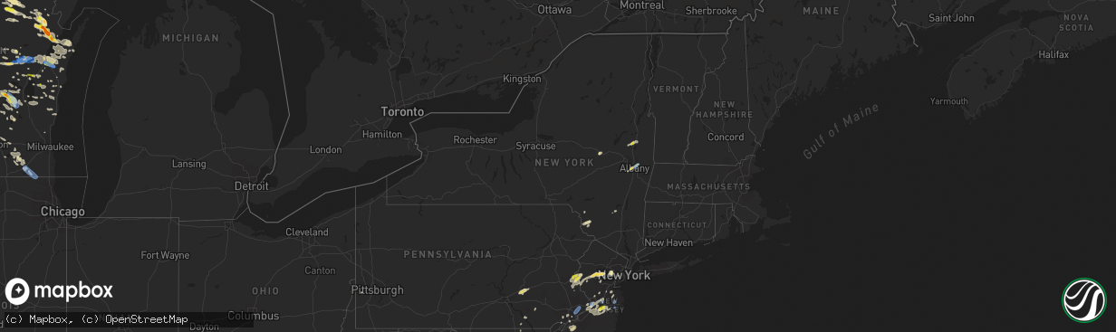
Hail Map in New York on August 7, 2019
The weather event in New York on August 7, 2019 includes Hail, Wind, and Tornado maps. 32 states and 948 cities were impacted and suffered possible damage. The total estimated number of properties impacted is 4,588.
Want more than just the map?
Turn this storm into a full workflow.
- Owner + property data so you know who to knock
- OnDemand branded weather history reports to win the "did we even have hail?" argument
- RoofTrace estimate so reps stop guessing numbers at the door
Bought this map? Upgrade within 7 days and we'll credit the $230. (10-15 min setup call)
Hail
Wind
Tornado
4,588
Estimated number of impacted properties by a 1.00" hail or larger0
Estimated number of impacted properties by a 1.75" hail or larger0
Estimated number of impacted properties by a 2.50" hail or largerStorm reports in New York
New York
| Date | Description |
|---|---|
| 08/07/20195:10 PM CDT | Tree limbs down on route 50. |
| 08/07/20195:07 PM CDT | Large tree limb down on maple ave |
| 08/07/20195:07 PM CDT | A local report indicates 1.00 inch wind near 2 N SARATOGA SPRINGS |
| 08/07/20195:05 PM CDT | Medium size tree down on north broadway |
| 08/07/20194:22 PM CDT | Large tree down |
| 08/07/20193:56 PM CDT | Tree down on mcdonald drive blocking the roadway |
| 08/07/20193:43 PM CDT | Tree down in the roadway on klein road near doodletown road |
| 08/07/20193:42 PM CDT | Tree down on powerlines on county route 11 off of state route 82 in the town of taghkanic |
| 08/07/20193:34 PM CDT | Trees down |
| 08/07/20193:28 PM CDT | Tree down on wires |
| 08/07/20193:25 PM CDT | Tree and wires down on route 32 |
| 08/07/20193:17 PM CDT | Trees down in town of palentine. |
| 08/07/20193:14 PM CDT | Trees down |
| 08/07/20193:13 PM CDT | Wires down on an unoccupied vehicle on delaware avenue in glasco |
| 08/07/20193:10 PM CDT | Power lines down on lillie road in the town of caanan |
| 08/07/20192:58 PM CDT | Tree down in the roadway on route 203 just west of route 22 |
| 08/07/20192:58 PM CDT | Multiple trees down route 55 near airport rd. |
| 08/07/20192:55 PM CDT | Tree down on rigor hill road near pratt hill road |
| 08/07/20192:54 PM CDT | Wires down on a vehicle at hurley mountain road and dug hill road |
| 08/07/20192:50 PM CDT | Tree down on hunt road near county route 21 |
| 08/07/20192:43 PM CDT | Tree and wires down on van wagenen lane |
| 08/07/20192:43 PM CDT | Tree and wires down on atwood road |
| 08/07/20192:43 PM CDT | Tree down on county route 7. |
| 08/07/20192:42 PM CDT | Tree and wires down on an occupied vehicle on atwood road |
| 08/07/20192:40 PM CDT | Tree and wires down on buck road |
| 08/07/20192:26 PM CDT | Tree down on county route 7. |
| 08/07/20192:19 PM CDT | Wires down near 394 route 17b. |
| 08/07/20191:46 PM CDT | Tree down on wires in the town of clinton |
| 08/07/20191:43 PM CDT | Trees and wires down on crumley vab vactor road... Between fraser road and gale road. |
| 08/07/20191:43 PM CDT | Tree down on a roof of a house near 54 plank road. |
| 08/07/20191:41 PM CDT | Trees and wires down blocking the roadway near 775 lt j g brender highway. |
| 08/07/20191:39 PM CDT | Multiple trees and wires down near 4028 state route 55 near camp toras. Buildings damaged as well. |
| 08/07/20191:34 PM CDT | Tree down on a porch |
| 08/07/20191:11 PM CDT | Route 2 closed between south lake avenue and west avenue due to downed wires |
| 08/07/20191:10 PM CDT | Tree down on sheldon avenue |
| 08/07/20191:09 PM CDT | Tree snapped and fell on a car on 3rd st in downtown troy |
| 08/07/20191:08 PM CDT | Two large trees snapped and numerous large branches down in and around the griswold heights apartment complex. Fire department has blocked off the area. |
| 08/07/20191:06 PM CDT | Quarter size hail on 6th ave |
| 08/07/20191:06 PM CDT | Two medium to large trees down on campbell ave near thomas street in troy |
| 08/07/20191:05 PM CDT | A local report indicates 1.00 inch wind near 2 S TROY |
| 08/07/20191:05 PM CDT | Several trees down on the east side of troy especially in the vicinity of pawling and campbell. One tree down on a vehicle. |
| 08/07/20191:04 PM CDT | Several large branches down on mill street near burden ave in troy |
| 08/07/20191:00 PM CDT | Tree down blocking the shoulder and right lane of interstate 787 |
| 08/07/201912:56 PM CDT | Tree down on water street near columbia street in downtown albany |
| 08/07/20192:04 AM CDT | At 704 PM EDT, a severe thunderstorm was located over Addison, moving northeast at 25 mph. HAZARD...60 mph wind gusts and quarter size hail. SOURCE...Radar indicated. IMPACT...Minor hail damage to vehicles is possible. Expect wind damage to trees and powerlines. Locations impacted include... South Burlington, Vergennes, Burlington, Middlebury, Essex, Willsboro, Westport, Weybridge, Monkton Ridge, Waterbury Village, Monkton, Monkton Boro, Williston, New Haven, Addison, Hinesburg, St. George, Starksboro, Shelburne and Ferrisburg. |
| 08/07/20191:05 AM CDT | At 605 PM EDT, a severe thunderstorm was located over Jamaica, moving east at 30 mph. HAZARD...60 mph wind gusts. SOURCE...Radar indicated. IMPACT...Expect damage to trees and power lines. This severe thunderstorm will be near... Throgs Neck Bridge and Cedarhurst around 610 PM EDT. Valley Stream and Woodmere around 615 PM EDT. Lynbrook and Great Neck around 620 PM EDT. Garden City and Mineola around 625 PM EDT. Freeport around 630 PM EDT. Westbury and Brookville around 635 PM EDT. Levittown and Hicksville around 640 PM EDT. Plainview and Massapequa around 645 PM EDT. |
| 08/07/20191:03 AM CDT | At 603 PM EDT, a severe thunderstorm was located near Saratoga Springs, moving east at 20 mph. HAZARD...60 mph wind gusts and quarter size hail. SOURCE...Radar indicated. IMPACT...Hail damage to vehicles is expected. Expect wind damage to roofs, siding, and trees. Locations impacted include... Saratoga Springs, Hudson Falls, Salem, Fort Edward, Hartford, Greenwich, Kings, Gates, Wilton, Greenfield, Northumberland, South Glens Falls, Schuylerville, Victory, Argyle, Deans Corners, Cossayuna, Dunham Basin, Center Falls and Goose Island. |
| 08/07/201912:02 AM CDT | At 501 PM EDT, severe thunderstorms were located along a line extending from near Tottenville to near Rocky Hill, moving northeast at 20 mph. HAZARD...60 mph wind gusts and penny size hail. SOURCE...Radar indicated. IMPACT...Damage to roofs, siding, trees, and power lines is possible. Locations impacted include... New Brunswick, Perth Amboy, Somerville, Somerset, Edison, Old Bridge, East Brunswick, South Brunswick, Sayreville, North Brunswick, Carteret, Middlesex, Princeton, Bound Brook, Manville, Keansburg, Matawan, Rocky Hill, Millstone and Brownville.This includes the following highways... Garden State Parkway between mile markers 118 and 133. Interstate 287 in New Jersey between mile markers 0 and 19. |
| 08/06/201911:42 PM CDT | At 442 PM EDT, a severe thunderstorm was located near Tribes Hill, or near Fonda, moving east at 30 mph. HAZARD...70 mph wind gusts and penny size hail. SOURCE...Radar indicated. IMPACT...Expect considerable tree damage. Damage is likely to mobile homes, roofs, and outbuildings. Locations impacted include... Schenectady, Amsterdam, Johnstown, Scotia, Fonda, Glenville, Niskayuna, Hagaman, Fort Johnson, Galway, Rotterdam Junction, East Glenville, Tribes Hill, Alplaus, Pattersonville-Rotterdam Junction, Charlton, Perth, Glen, Charleston and Fultonville. |
| 08/06/201911:34 PM CDT | At 434 PM EDT, a severe thunderstorm was located over Twin Rivers, or 13 miles south of New Brunswick, moving northeast at 30 mph. HAZARD...60 mph wind gusts and penny size hail. SOURCE...Radar indicated. IMPACT...Damage to roofs, siding, trees, and power lines is possible. Locations impacted include... New Brunswick, Perth Amboy, Edison, Old Bridge, East Brunswick, Sayreville, North Brunswick, Manalapan, Carteret, Keansburg, Matawan, Jamesburg, Hightstown, Cranbury, Roosevelt, Colonia, Brownville, Dayton, Robertsville and North Brunswick Township.This includes the following highways... Garden State Parkway between mile markers 117 and 134. Interstate 195 in New Jersey between mile markers 15 and 16. Interstate 287 in New Jersey between mile markers 0 and 4. |
| 08/06/201911:22 PM CDT | At 422 PM EDT, a severe thunderstorm was located over Wells, or 15 miles south of Speculator, moving east at 20 mph. HAZARD...60 mph wind gusts and quarter size hail. SOURCE...Radar indicated. IMPACT...Hail damage to vehicles is expected. Expect wind damage to roofs, siding, and trees. Locations impacted include... Lake Pleasant, Wells, Sacandaga Campground, Harrisburg, Hope, Gilmantown, Girards Sugarbush, Hope Falls, Griffin, Blackbridge and Bakertown. |
| 08/06/201911:16 PM CDT | At 415 PM EDT, a severe thunderstorm was located over Canajoharie, moving northeast at 30 mph. HAZARD...60 mph wind gusts and quarter size hail. SOURCE...Radar indicated. IMPACT...Hail damage to vehicles is expected. Expect wind damage to roofs, siding, and trees. Locations impacted include... Amsterdam, Gloversville, Johnstown, Canajoharie, Fonda, Fort Plain, Ephratah, Broadalbin, Hagaman, Mayfield, Fort Johnson, Ames, Tribes Hill, Cranberry Creek, Caroga Lake Public Campground, Northampton Beach Public Campground, Perth, Glen, Berkshire and Fultonville. |
| 08/06/201910:59 PM CDT | At 359 PM EDT, a severe thunderstorm was located over Brownville, or 7 miles south of Perth Amboy, moving northeast at 20 mph. HAZARD...60 mph wind gusts and penny size hail. SOURCE...Radar indicated. IMPACT...Damage to roofs, siding, trees, and power lines is possible. Locations impacted include... Perth Amboy, Old Bridge, East Brunswick, Sayreville, Carteret, Keansburg, Matawan, Jamesburg, Brownville, Robertsville, Clearbrook Park, Yorketown, Whittingham, Morganville, Woodbridge, South River, Spotswood, Keyport, Helmetta and Englishtown.This includes Garden State Parkway between mile markers 115 and 130. |
| 08/06/201910:52 PM CDT | At 352 PM EDT, a severe thunderstorm was located over Hurley, or near Kingston, moving northeast at 25 mph. HAZARD...60 mph wind gusts and penny size hail. SOURCE...Radar indicated. IMPACT...Expect damage to roofs, siding, and trees. Locations impacted include... Kingston, Saugerties, Rhinebeck, Hurley, Woodstock, Clermont, Red Hook, High Falls, Tillson, West Hurley, Saugerties South, Port Ewen, Lake Katrine, Olivebridge, Rosendale, Marbletown, Veteran, Germantown, Tivoli and Centerville. |
| 08/06/201910:46 PM CDT | At 346 PM EDT, a severe thunderstorm was located over Canajoharie, moving northeast at 20 mph. HAZARD...60 mph wind gusts and quarter size hail. SOURCE...Radar indicated. IMPACT...Hail damage to vehicles is expected. Expect wind damage to roofs, siding, and trees. Locations impacted include... Gloversville, Johnstown, Canajoharie, Fonda, Fort Plain, St. Johnsville, Ephratah, Fort Johnson, Ames, Tribes Hill, Glen, Fultonville, Palatine Bridge, Nelliston, Meco, Cook Corners, Church Corners, Hale Mills, McKinley and Square Barn Corners. |
| 08/06/201910:37 PM CDT | At 337 PM EDT, a severe thunderstorm was located near Battle Island State Park, or 7 miles northeast of Fulton, moving northeast at 15 mph. HAZARD...60 mph wind gusts. SOURCE...Radar indicated. IMPACT...Expect damage to roofs, siding, and trees. Locations impacted include... Pulaski, Selkirk Shores State Park, Mexico Point State Park, Hastings, Palermo, New Haven, Mexico, Parish, Port Ontario and Howardville. This includes Interstate 81 between exits 33 and 36. |
| 08/06/201910:35 PM CDT | At 335 PM EDT, a severe thunderstorm was located over Kerhonkson, or near Ellenville, moving northeast at 15 mph. HAZARD...60 mph wind gusts and penny size hail. SOURCE...Radar indicated. IMPACT...Expect damage to roofs, siding, and trees. Locations impacted include... Ellenville, Tillson, Kerhonkson, Napanoch, Wawarsing, Rosendale, Marbletown, Port Ben, Cherrytown, Lefever Falls, Maple Hill, Atwood, Liebhardt, Fantinekill, Alligerville, Lake Minnewaska, Stone Ridge, Granite, Mombaccus and Honk Hill. |
| 08/06/201910:21 PM CDT | At 321 PM EDT, a severe thunderstorm was located near Napanoch, or 10 miles north of Ellenville, moving northeast at 30 mph. HAZARD...60 mph wind gusts and penny size hail. SOURCE...Radar indicated. IMPACT...Expect damage to roofs, siding, and trees. Locations impacted include... Kingston, Hurley, Woodstock, West Shokan, Kenneth L Wilson Campground, West Hurley, Olivebridge, Cherrytown, Rolling Meadows, Glenford, Palentown, Atwood, Sweet Meadows, Pacama, Brodhead, Liebhardt, Hillside, Zena, Morgan Hill and Mombaccus. |
| 08/06/20199:30 PM CDT | At 230 PM EDT, severe thunderstorms were located along a line extending from Edison to Old Bridge, moving east at 25 mph. HAZARD...70 mph wind gusts and penny size hail. SOURCE...Radar indicated. IMPACT...Expect considerable tree damage. Damage is likely to mobile homes, roofs, and outbuildings. Locations impacted include... New Brunswick, Perth Amboy, Sandy Hook, Edison, Middletown, Old Bridge, East Brunswick, Sayreville, Marlboro, Carteret, Tinton Falls, Holmdel, Red Bank, Keansburg, Matawan, Highlands, Colonia, Brownville, Robertsville and Yorketown.This includes the following highways... Garden State Parkway between mile markers 109 and 134. Interstate 287 in New Jersey between mile markers 0 and 4. |
| 08/06/20199:18 PM CDT | At 217 PM EDT, a severe thunderstorm was located over Millington, or near Morristown, moving east at 25 mph. HAZARD...60 mph wind gusts and quarter size hail. SOURCE...Radar indicated. IMPACT...Minor hail damage to vehicles is possible. Expect wind damage to trees and power lines. This severe thunderstorm will be near... Plainfield around 230 PM EDT. Summit around 245 PM EDT. Millburn and Clark around 250 PM EDT. Newark and Elizabeth around 300 PM EDT. |
| 08/06/20199:15 PM CDT | At 214 PM EDT, a severe thunderstorm was located over Troy, moving northeast at 25 mph. HAZARD...60 mph wind gusts and quarter size hail. SOURCE...Radar indicated. IMPACT...Hail damage to vehicles is expected. Expect wind damage to roofs, siding, and trees. Locations impacted include... Troy, Cohoes, Watervliet, Rensselaer, Latham, Menands, Green Island, Grafton, Waterford, Berlin, Loudonville, West Sand Lake, Center Brunswick, Wyantskill, Wynantskill, Averill Park, North Greenbush, Brunswick, Pittstown and Poestenkill. |
| 08/06/20199:06 PM CDT | At 205 PM EDT, a severe thunderstorm was located near Utica, moving northeast at 15 mph. HAZARD...60 mph wind gusts. SOURCE...Radar indicated. IMPACT...Expect damage to roofs, siding, and trees. This severe thunderstorm will remain over mainly rural areas of east central Oneida County. |
| 08/06/20198:47 PM CDT | At 146 PM EDT, a severe thunderstorm was located over Hazel, or 9 miles northwest of Liberty, moving northeast at 20 mph. HAZARD...60 mph wind gusts and penny size hail. SOURCE...Radar indicated. IMPACT...Expect damage to roofs, siding, and trees. Locations impacted include... Rockland, Margaretville, Hazel, Livingston Manor, Willowemoc, Roscoe, Dunraven, Callicoon Center, Shandelee and Waneta Lake. |
| 08/06/20198:45 PM CDT | At 144 PM EDT, a severe thunderstorm was located over Albany, moving northeast at 20 mph. HAZARD...60 mph wind gusts and quarter size hail. SOURCE...Radar indicated. IMPACT...Hail damage to vehicles is expected. Expect wind damage to roofs, siding, and trees. Locations impacted include... Albany, Troy, East Greenbush, Cohoes, Watervliet, Rensselaer, Colonie, Latham, Delmar, Guilderland, Menands, Voorheesville, Green Island, Waterford, Loudonville, Center Brunswick, Wyantskill, Wynantskill, North Greenbush and Brunswick. |
All States Impacted by Hail Map on August 7, 2019
Cities Impacted by Hail Map on August 7, 2019
- Black Creek, WI
- Ballston Spa, NY
- Saratoga Springs, NY
- Greenfield Center, NY
- Rock City Falls, NY
- Gansevoort, NY
- Middle Grove, NY
- Mullica Hill, NJ
- Sewell, NJ
- Mantua, NJ
- Clarksboro, NJ
- Swedesboro, NJ
- Mickleton, NJ
- Woodstown, NJ
- White Hall, MD
- Gloucester, VA
- Wade, NC
- Moulton, AL
- Sturgeon Bay, WI
- Allen, KS
- Emporia, KS
- Crivitz, WI
- Cody, NE
- Wausaukee, WI
- White Lake, WI
- Pickerel, WI
- Elcho, WI
- Crandon, WI
- Pearson, WI
- Natoma, KS
- Plainville, KS
- Rice Lake, WI
- Weyerhaeuser, WI
- Bruce, WI
- Linn Creek, MO
- Stoutland, MO
- Montreal, MO
- Louisa, VA
- Palmyra, VA
- Kents Store, VA
- Goochland, VA
- Columbia, VA
- Matador, TX
- Paragould, AR
- Peach Orchard, AR
- Pocahontas, AR
- Maynard, AR
- Beech Grove, AR
- Biggers, AR
- Delaplaine, AR
- New Franken, WI
- Suamico, WI
- Luxemburg, WI
- Green Bay, WI
- Frederick, MD
- Ijamsville, MD
- Adamstown, MD
- Orchard, NE
- Page, NE
- Hawk Springs, WY
- Shaniko, OR
- Salina, KS
- Brookville, KS
- Baxter Springs, KS
- Quapaw, OK
- Stanton, TN
- Colome, SD
- Winner, SD
- New Egypt, NJ
- Cream Ridge, NJ
- Joffre, PA
- Burgettstown, PA
- Cheyenne Wells, CO
- Arapahoe, CO
- Green Lake, WI
- Ripon, WI
- Berlin, WI
- Naper, NE
- Black River Falls, WI
- Warrens, WI
- Pittsville, WI
- Delavan, WI
- Whitewater, WI
- Burlington, CO
- Disputanta, VA
- Spring Grove, VA
- Waverly, VA
- Courtland, VA
- Capron, VA
- Claude, TX
- Huntsville, AL
- Harvest, AL
- Pocahontas, TN
- Selmer, TN
- Emporia, VA
- Gladstone, NJ
- Califon, NJ
- Far Hills, NJ
- Hazel Green, AL
- Manistique, MI
- Cooks, MI
- Bryant, WI
- Merrillan, WI
- Keiser, AR
- Folkston, GA
- Carpenter, WY
- Hornbeak, TN
- Eureka, KS
- Hamilton, KS
- Fredonia, KS
- Benedict, KS
- Sheridan Lake, CO
- Tribune, KS
- Warm Springs, AR
- Cornersville, TN
- Lynnville, TN
- Culleoka, TN
- Yorktown, VA
- Arnett, OK
- Durham, OK
- Kimberly, WI
- Little Chute, WI
- Combined Locks, WI
- Appleton, WI
- Kaukauna, WI
- Sherwood, MD
- Cordova, MD
- Saint Michaels, MD
- Royal Oak, MD
- Chester, MD
- Tilghman, MD
- Prince Frederick, MD
- Wittman, MD
- Saint Leonard, MD
- Port Republic, MD
- Easton, MD
- Mcdaniel, MD
- Bozman, MD
- Queenstown, MD
- Neavitt, MD
- Stevensville, MD
- Grasonville, MD
- Claiborne, MD
- Wiggins, CO
- Marengo, WI
- Mellen, WI
- Glidden, WI
- Clam Lake, WI
- Seymour, WI
- Hortonville, WI
- New London, WI
- Watervliet, NY
- Albany, NY
- Delmar, NY
- Slingerlands, NY
- Troy, NY
- Roscoe, NY
- Blounts Creek, NC
- Washington, NC
- Bath, NC
- Ward, AR
- Lonoke, AR
- Tescott, KS
- Beverly, KS
- Lincoln, KS
- Grand Junction, TN
- Saulsbury, TN
- Lagrange, WY
- Brodnax, VA
- Paris, AR
- Tigerton, WI
- Henning, TN
- Ripley, TN
- Happy, TX
- Gypsum, KS
- Newport, NE
- Wheatland, WY
- Thayer, KS
- Fall River, KS
- Altoona, KS
- Longton, KS
- Liberty, KS
- Mound Valley, KS
- Dennis, KS
- Cherryvale, KS
- Neodesha, KS
- Independence, KS
- Toronto, KS
- Red House, VA
- Brookneal, VA
- Burke, SD
- Coleman, WI
- Pound, WI
- Brussels, WI
- Lena, WI
- Oconto, WI
- Peshtigo, WI
- Humboldt, KS
- Iola, KS
- Elsmore, KS
- Chanute, KS
- Erie, KS
- Piqua, KS
- Savonburg, KS
- Moran, KS
- Yates Center, KS
- La Harpe, KS
- Mission, SD
- Platte, SD
- Easton, PA
- Cochecton, NY
- Bethel, NY
- Swan Lake, NY
- Narrowsburg, NY
- White Lake, NY
- Edgar, WI
- Mosinee, WI
- Tarboro, NC
- Rocky Mount, NC
- Altus, AR
- Ozark, AR
- Magazine, AR
- New Bern, NC
- Ernul, NC
- Neshkoro, WI
- Brush, CO
- Snyder, CO
- Hillrose, CO
- Spencer, WI
- Brillion, WI
- Potter, WI
- Hilbert, WI
- Chilton, WI
- Blairstown, MO
- Bassett, NE
- Woodston, KS
- Roland, AR
- Short Hills, NJ
- Livingston, NJ
- West Orange, NJ
- Millburn, NJ
- Harrison, SD
- Armour, SD
- Corsica, SD
- Dallas, SD
- Mills, NE
- Gregory, SD
- Assaria, KS
- Lindsborg, KS
- Falun, KS
- Maupin, OR
- Marshall, AR
- Winneconne, WI
- Omro, WI
- Fremont, WI
- Powhatan, VA
- Brandon, WI
- Agate, CO
- Stuart, NE
- Atkinson, NE
- Taylor, WI
- Cherokee, AL
- Marion, KS
- Phillipsburg, NJ
- Bloomsbury, NJ
- Myerstown, PA
- Fredericksburg, PA
- Annville, PA
- Lebanon, PA
- Jonestown, PA
- Paradise, KS
- Oshkosh, WI
- Kilgore, NE
- Nenzel, NE
- Joint Base Mdl, NJ
- Wrightstown, NJ
- Allentown, NJ
- Chesterfield, NJ
- Jonesboro, AR
- Jefferson, WI
- Stover, MO
- Cole Camp, MO
- Dover, AR
- Geddes, SD
- Morrisville, PA
- Florence, NJ
- Bristol, PA
- Reno, NV
- Asbury, NJ
- Stewartsville, NJ
- Matfield Green, KS
- Sunrise Beach, MO
- Halifax, NC
- Belhaven, NC
- Hackett, AR
- Adams, WI
- Grand Marsh, WI
- Oxford, WI
- Westfield, WI
- Lenora, KS
- Clayton, KS
- Chugwater, WY
- Columbus, WI
- Reeseville, WI
- Beaver Dam, WI
- Ellington, MO
- McMillan, MI
- Alcester, SD
- Centerville, KS
- Mound City, KS
- Laona, WI
- Argonne, WI
- Fairwater, WI
- Redgranite, WI
- Fox Lake, WI
- Dresden, KS
- Amagon, AR
- Fisher, AR
- Vinemont, AL
- Falkville, AL
- Crookston, NE
- Valentine, NE
- Sanford, NC
- Summit, NJ
- Springfield, NJ
- Maplewood, NJ
- Grass Valley, OR
- Kent, OR
- Centerview, MO
- Warrensburg, MO
- Drummonds, TN
- Wilson, AR
- Osceola, AR
- Covington, TN
- Burlison, TN
- Quartzsite, AZ
- Springview, NE
- Le Roy, KS
- Colony, KS
- Waverly, KS
- Burlington, KS
- Neosho Falls, KS
- Westphalia, KS
- Lebo, KS
- Newport, AR
- Palatine Bridge, NY
- Fort Plain, NY
- Canajoharie, NY
- Dundee, MS
- Tunica, MS
- Elkhorn, WI
- Coldwater, KS
- Tyndall, SD
- Dinwiddie, VA
- Petersburg, VA
- Utica, SD
- Menno, SD
- Jarrettsville, MD
- Street, MD
- Raleigh, NC
- Cary, NC
- Apex, NC
- Virgil, KS
- Arriba, CO
- Admire, KS
- Reading, KS
- Americus, KS
- Watkinsville, GA
- Inman, KS
- Pocomoke City, MD
- Oberlin, KS
- Selden, KS
- Protection, KS
- Tampa, KS
- Durham, KS
- Irene, SD
- Lesterville, SD
- Nevada, MO
- Richards, MO
- Howard, KS
- Toney, AL
- Leola, PA
- Ronks, PA
- Bird In Hand, PA
- Waldo, KS
- Luray, KS
- Barnard, KS
- Sylvan Grove, KS
- Lucas, KS
- Alton, KS
- Hunter, KS
- Sterling, VA
- Potomac, MD
- Poolesville, MD
- Gaithersburg, MD
- Germantown, MD
- Haven, KS
- Hutchinson, KS
- Friendship, WI
- Coloma, WI
- Reedsville, WI
- Cheyenne, WY
- Fort Morgan, CO
- Everton, AR
- Saint Joe, AR
- Snow Hill, NC
- Hookerton, NC
- Limon, CO
- Pleasanton, KS
- Columbus, KS
- Galena, KS
- Riverton, KS
- Crossett, AR
- Lebanon, MO
- Richland, MO
- Brumley, MO
- Whitelaw, WI
- Maribel, WI
- Wray, CO
- Bogue, KS
- Blue Mound, KS
- Tuthill, SD
- Martin, SD
- Cedar Point, KS
- Sun Prairie, WI
- Cambria, WI
- Randolph, WI
- Walker, MO
- Sulphur Rock, AR
- Bloomfield, NE
- Witten, SD
- Obion, TN
- Troy, TN
- Canyon, TX
- Mount Calvary, WI
- Malone, WI
- Fond Du Lac, WI
- Seaford, VA
- Albertson, NC
- Pink Hill, NC
- Kinston, NC
- Trenton, NC
- Dover, NC
- Menasha, WI
- Preston, MD
- Sparks, NV
- Genoa, CO
- Windsor, VA
- Smithfield, VA
- Springfield, SD
- Avon, SD
- Tripp, SD
- Niobrara, NE
- Marianna, AR
- Marion, WI
- Clintonville, WI
- Mountain View, AR
- Carlisle, AR
- Taft, TN
- Fayetteville, TN
- Briggsdale, CO
- Neal, KS
- Algoma, WI
- Casco, WI
- Columbia, TN
- Needles, CA
- Coffeyville, KS
- Cassoday, KS
- Stratford, WI
- Jarratt, VA
- Sedley, VA
- Wabeno, WI
- Vona, CO
- Licking, MO
- Williamsburg, VA
- Emmet, NE
- Oneill, NE
- Athelstane, WI
- Shiocton, WI
- Chili, WI
- Marshfield, WI
- Hillsboro, WI
- Eldred, NY
- La Cygne, KS
- Godwin, NC
- Saint Francis, SD
- Pemberton, NJ
- Jackson, NJ
- Jobstown, NJ
- Columbus, NJ
- Manawa, WI
- Kanorado, KS
- Babcock, WI
- Byers, CO
- Suffolk, VA
- Clayton, NC
- Manchester, TN
- Ellinwood, KS
- Cherry Valley, AR
- Bernardsville, NJ
- Basking Ridge, NJ
- Germfask, MI
- Eleva, WI
- Bluffton, SC
- Lyndon, KS
- Clinton, MO
- Batesville, AR
- Lillington, NC
- Bloomfield, NJ
- Dickerson, MD
- Monrovia, MD
- Bluejacket, OK
- Okatie, SC
- Athens, WI
- Mullinville, KS
- Delmont, SD
- Iuka, MS
- Burnsville, MS
- Fort Leavenworth, KS
- Weiner, AR
- Witts Springs, AR
- Hector, AR
- Toone, TN
- Whiteville, TN
- Bolivar, TN
- Austin, AR
- Bulger, PA
- Buhler, KS
- Autryville, NC
- Roseboro, NC
- Salemburg, NC
- Junction City, WI
- De Pere, WI
- Newark, NJ
- Warren, NJ
- Martinsville, NJ
- Bridgewater, NJ
- Somerville, NJ
- Centerville, TN
- Glen, MS
- Russellville, AL
- Larsen, WI
- Oil Trough, AR
- Dellrose, TN
- Quakertown, PA
- Kintnersville, PA
- Cash, AR
- Rogersville, AL
- Anderson, AL
- Elkmont, AL
- Athens, AL
- Atwood, KS
- Gravois Mills, MO
- Manassas, VA
- Centreville, VA
- Loyal, WI
- Granton, WI
- Neillsville, WI
- Cedar Grove, TN
- Parmelee, SD
- Millington, TN
- Pleasant Grove, AR
- Marcella, AR
- Sedgwick, KS
- Madison, AL
- Aulander, NC
- Windsor, NC
- Norfolk, VA
- Alta Vista, KS
- Eskridge, KS
- Alma, KS
- Bear Creek, WI
- Des Arc, AR
- Hebron, IL
- Harvard, IL
- Virginia Beach, VA
- Chesapeake, VA
- Portsmouth, VA
- Lake Geneva, WI
- Genoa City, WI
- Westerville, OH
- Galena, OH
- Garnet Valley, PA
- Wilmington, DE
- Chadds Ford, PA
- Goodman, MO
- Seneca, MO
- Neosho, MO
- Newark, AR
- Lowland, NC
- Waterloo, AL
- Townsend, WI
- Lakewood, WI
- Pollocksville, NC
- Gleason, WI
- Yoder, WY
- Lawrenceville, VA
- La Crosse, VA
- White Plains, VA
- Ebony, VA
- Little Rock, AR
- Fontana, KS
- Edna, KS
- Elk City, KS
- Buffalo, KS
- Caroline, WI
- Dyer, TN
- Manila, AR
- Osseo, WI
- Fort Atkinson, WI
- Marlboro, NJ
- Morganville, NJ
- Englishtown, NJ
- Front Royal, VA
- Fort Valley, VA
- Bentonville, VA
- Bellvue, CO
- Loveland, CO
- Maysville, NC
- Woodville, AL
- Paint Rock, AL
- Kimball, SD
- Saint Paul, KS
- Aurora, NC
- Parkston, SD
- New Holland, SD
- Greenwood, WI
- Markesan, WI
- Princeton, WI
- Catharine, KS
- Leavenworth, KS
- Kansas City, KS
- Enid, OK
- Defuniak Springs, FL
- Daufuskie Island, SC
- Greenville, WI
- Doniphan, MO
- Fremont, MO
- Long Valley, NJ
- Lebanon, NJ
- Ettrick, WI
- Eads, CO
- Wautoma, WI
- Uniontown, KS
- Williamsport, TN
- Rhinelander, WI
- Amherst Junction, WI
- Scandinavia, WI
- Iola, WI
- Ogdensburg, WI
- Cockeysville, MD
- Phoenix, MD
- Broomall, PA
- Media, PA
- Newtown Square, PA
- Springfield, PA
- Battleboro, NC
- Nichols, WI
- Pulaski, WI
- Bonduel, WI
- Florence, AL
- Plymouth, WI
- Waldo, WI
- Sheboygan Falls, WI
- Minneola, KS
- Drewryville, VA
- Florham Park, NJ
- South Orange, NJ
- Chatham, NJ
- Union, NJ
- Vauxhall, NJ
- Forestville, WI
- Crum Lynne, PA
- Woodlyn, PA
- Ridley Park, PA
- Deer Trail, CO
- Prescott, KS
- Morristown, NJ
- Chester, NJ
- New Vernon, NJ
- Peapack, NJ
- Mauston, WI
- Reedsburg, WI
- Baraboo, WI
- Perkasie, PA
- Howard, OH
- Walhonding, OH
- Cottonwood Falls, KS
- Cove City, NC
- Waterloo, WI
- Lake Mills, WI
- Lake City, AR
- Brookland, AR
- Mountain, WI
- Langhorne, PA
- Levittown, PA
- Fairless Hills, PA
- Mason, TN
- Arlington, TN
- Edgerton, WI
- Dendron, VA
- Welch, OK
- Bartlett, KS
- Valley Springs, AR
- Yellville, AR
- Duck River, TN
- Sharon, CT
- Fuquay Varina, NC
- Pachuta, MS
- Burrton, KS
- Kit Carson, CO
- Belle Plaine, KS
- Wellington, KS
- Altamont, KS
- Oswego, KS
- Charles City, VA
- Providence Forge, VA
- Hixton, WI
- Alma Center, WI
- Abilene, KS
- Paola, KS
- Alicia, AR
- Hoxie, AR
- Grifton, NC
- Memphis, TN
- Kansas City, MO
- Riegelsville, PA
- Milford, NJ
- Washington, NJ
- Arpin, WI
- Necedah, WI
- Boydton, VA
- Denmark, WI
- Kewaunee, WI
- Stone Ridge, NY
- Accord, NY
- New Park, PA
- Felton, PA
- Airville, PA
- Locust Grove, AR
- Thorp, WI
- Kiel, WI
- New Holstein, WI
- Hermitage, AR
- Saint Francis, KS
- Shawano, WI
- Lake Ozark, MO
- Holly, CO
- Dunn, NC
- Hardeeville, SC
- Burlington, NC
- Haw River, NC
- Arcadia, WI
- Mount Olive, NC
- Mongaup Valley, NY
- Knobel, AR
- Lafe, AR
- Stickney, SD
- Manitowoc, WI
- Chetopa, KS
- Windsor, NJ
- Hightstown, NJ
- Robbinsville, NJ
- Bordentown, NJ
- Mount Holly, NJ
- Beverly, NJ
- Lakehurst, NJ
- Trenton, NJ
- Bensalem, PA
- Browns Mills, NJ
- Vincentown, NJ
- Cookstown, NJ
- Burlington, NJ
- Croydon, PA
- Parsons, KS
- McCune, KS
- Carthage, NC
- Van Dyne, WI
- Gatewood, MO
- Butte, NE
- Pittstown, NJ
- Annandale, NJ
- Helena, AR
- Weldona, CO
- Saint Paul, AR
- New Hill, NC
- Hartington, NE
- Scotland, SD
- Wausa, NE
- Wagner, SD
- Waupun, WI
- Pleasant City, OH
- Kent, OH
- Oviedo, FL
- Ono, PA
- Shell Knob, MO
- Berryville, AR
- Sandy Hook, VA
- Maidens, VA
- Windsor, MO
- Wetmore, MI
- Rapid River, MI
- Feura Bush, NY
- Amissville, VA
- Marshall, VA
- Rosalia, KS
- Severy, KS
- Piedmont, KS
- Brownsville, TN
- Oakland, TN
- Rossville, TN
- Old Bridge, NJ
- Matawan, NJ
- Hudson, SD
- Huntingtown, MD
- Valley Center, KS
- Pelican Lake, WI
- Halstead, KS
- Okreek, SD
- Wood, SD
- Oconto Falls, WI
- Suring, WI
- Lewisburg, TN
- Walnut Ridge, AR
- Ayden, NC
- Princeton, NJ
- Monmouth Junction, NJ
- Kingston, NJ
- Monette, AR
- Wittenberg, WI
- Madison, KS
- Tanner, AL
- Rosebud, SD
- Norris, SD
- Conestoga, PA
- Elkhart Lake, WI
- Saint Cloud, WI
- Mount Judea, AR
- Mason, WI
- Mays Landing, NJ
- Hayes, VA
- Faison, NC
- Stokes, NC
- Greenville, NC
- Hilliard, FL
- Oneida, WI
- Rosendale, WI
- Eldorado, WI
- Pickett, WI
- Senecaville, OH
- Spring Hill, TN
- Waynesville, MO
- Coats, NC
- Hattiesburg, MS
- Penokee, KS
- Cleveland, WI
- Newton, WI
- Savannah, GA
- Morland, KS
- Green Village, NJ
- Eland, WI
- Goodland, KS
- Annapolis, MD
- Crosbyton, TX
- Ottsville, PA
- Upper Black Eddy, PA
- Bethlehem, PA
- Bedminster, NJ
- High Bridge, NJ
- Frenchtown, NJ
- Hampton, NJ
- Clinton, NJ
- Hellertown, PA
- Mendham, NJ
- Conway, NC
- Murfreesboro, NC
- Vossburg, MS
- Conrath, WI
- Glen Arm, MD
- Nottingham, MD
- Perry Hall, MD
- Parkville, MD
- Boyds, MD
- Clarksburg, MD
- Barnesville, MD
- Cedarburg, WI
- Lansdowne, PA
- Cordova, TN
- Mount Pleasant, SC
- Phenix, VA
- Willard, WI
- Lawrence Township, NJ
- Glen Mills, PA
- Spotsylvania, VA
- Stedman, NC
- East Brunswick, NJ
- Lewiston Woodville, NC
- Kelford, NC
- Oostburg, WI
- Cedar Grove, WI
- Knob Noster, MO
- Ionia, MO
- Hartford, KS
- Stony Creek, VA
- Flintville, TN
- Marshall, WI
- Rector, AR
- Munising, MI
- Arkdale, WI
- Valders, WI
- Hopewell, VA
- Cumberland, OH
- Susan, VA
- Willow Spring, NC
- Guion, AR
- Melbourne, AR
- New Market, AL
- Appomattox, VA
- Clarendon, TX
- Unity, WI
- Hewitt, WI
- Richmond, IL
- Twin Lakes, WI
- Burlington, WI
- Spring Grove, IL
- Williams Bay, WI
- Bryn Athyn, PA
- Bala Cynwyd, PA
- Huntingdon Valley, PA
- Elkins Park, PA
- Jenkintown, PA
- Abington, PA
- Cheltenham, PA
- Philadelphia, PA
- Wyncote, PA
- Glenside, PA
- Easthampton, MA
- Southampton, MA
- Howell, NJ
- Freehold, NJ
- Farmingdale, NJ
- Lakewood, NJ
- Sykesville, MD
- Mount Airy, MD
- New Market, MD
- Crofton, NE
- Tabor, SD
- Rensselaer, NY


