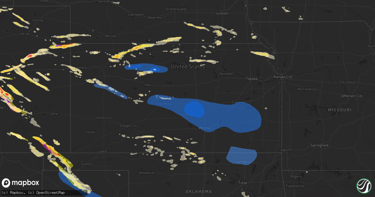
Hail Map in Kansas on August 5, 2023
Get this storm
August 5 map
$229
one time, instant access
Download today. No call, no setup
Keep the $229
Bought the map and want the full workflow? Apply the entire $229 to a subscription within 7 days. None of it is wasted.
Every map, not just this one
This buys you this map. Subscription and you get every map we run, in the markets you choose from a few cities to whole states to nationwide. Plus real-time alerts the moment a storm fires.
Contact data
Name, contact info, occupancy, even credit band for addresses in the footprint. You go from where it hit to who to call.
Become the source they trust
Unlimited branding weather history reports on demand. You already have the documented answer ready for the property owner, and you are the one who showed up with it.
Property data and RoofTrace estimates
Pull up any address you have got, its value and the exact code rules for that jurisdiction, straight from One Click Code. Then RoofTrace estimates the squares, pitch, and roof value, priced the way you price.
Storm reports in Kansas
Kansas
| Date | Description |
|---|---|
| 08/05/202311:55 AM CDT | A local report indicates 60 MPH wind near Wamego |
| 08/05/202311:23 AM CDT | 2 foot diameter tree branch down. |
| 08/05/20237:52 AM CDT | 2-3 inch tree limbs down in town. |
| 08/05/20237:52 AM CDT | A local report indicates 65 MPH wind near Tyro |
| 08/05/20237:20 AM CDT | A local report indicates 60 MPH wind near Sedan |
| 08/05/20231:30 AM CDT | 8 inch tree limbs down as well as many 4 to 5 inch tree limbs broken off. |
| 08/05/20231:16 AM CDT | A local report indicates 59 MPH wind near Chanute |
| 08/05/202312:53 AM CDT | Kfoe. |
| 08/05/202312:31 AM CDT | A local report indicates 60 MPH wind near Eureka |
| 08/05/202312:29 AM CDT | A local report indicates 72 MPH wind near 2 N Eureka |
| 08/05/202312:27 AM CDT | Damaged power pole at the north end of the city; some power outages in the area. Also a report of a tree down on the west side of el dorado |
| 08/05/202312:21 AM CDT | A local report indicates 63 MPH wind near 4 E Matfield Green |
| 08/05/202312:15 AM CDT | A local report indicates 73 MPH wind near 1 W El Dorado |
| 08/05/202312:02 AM CDT | Power outage. |
| 08/05/202312:02 AM CDT | Lines down... Poles on fire in wichita metro area. |
| 08/04/202311:58 PM CDT | Corrects previous tstm wnd dmg report from potwin. |
| 08/04/202311:55 PM CDT | Vehicle accident on us 50 and rock road. |
| 08/04/202311:54 PM CDT | Several branches down. |
| 08/04/202311:51 PM CDT | Northbound lane of i-135 blocked due to vehicle accident in vicinity of highway 50 exit... Vicinity of rest area. |
| 08/04/202311:51 PM CDT | A local report indicates 61 MPH wind near 3 ESE Bel Aire |
| 08/04/202311:50 PM CDT | Personal weather station measured 62 mph gust. |
| 08/04/202311:45 PM CDT | Corrects previous tstm wnd dmg report from 4 s maize. Delayed report. Time based on radar. Approximately 12 inch diameter tree branch downed. |
| 08/04/202311:45 PM CDT | Delayed report. Time based on radar. |
| 08/04/202311:41 PM CDT | A local report indicates 70 MPH wind near Newton |
| 08/04/202311:39 PM CDT | A local report indicates 70 MPH wind near 1 E Sedgwick |
| 08/04/202311:37 PM CDT | A local report indicates 70 MPH wind near Goessel |
| 08/04/202311:31 PM CDT | Personal weather station measured wind gust. |
| 08/04/202311:28 PM CDT | Delayed report of an uprooted tree in hesston. Received via social media and the report time was estimated via radar. |
| 08/04/202311:26 PM CDT | Delayed report via social media of a tree trunk nearly completely snapped. Health of the tree is unknown. Time of the report was estimated via radar. |
| 08/04/202311:25 PM CDT | Corrects previous tstm wnd dmg report from mount hope. |
| 08/04/202311:23 PM CDT | Extremely high winds in the city of mcpherson right now. Several locations without power 11:24 we |
| 08/04/202311:23 PM CDT | Extremely high winds in the city of mcpherson right now. Several locations without power 11:24 we have downed power lines at avenue a and main street in the city of mcp |
| 08/04/202311:20 PM CDT | 2 foot diameter tree branch down. |
| 08/04/202311:18 PM CDT | A local report indicates 80 MPH wind near Mcpherson |
| 08/04/202311:16 PM CDT | Estimated 60-70 mph. |
| 08/04/202311:15 PM CDT | Large tree limbs down... Size was 4 to 5 inch limbs which caused some roof damage to a home. |
| 08/04/202311:15 PM CDT | A local report indicates 63 MPH wind near Mcpherson Airport |
| 08/04/202311:15 PM CDT | 70+ estimated wind gusts north central part of hutchinson- north of fairgrounds. Power is out. No hail... Heavy rain & strong winds continue. Some large tree damage . |
| 08/04/202311:14 PM CDT | Delayed report via social media of 4 to 5 inch diameter tree limbs snapped. Time estimated via radar. |
| 08/04/202311:13 PM CDT | A local report indicates 74 MPH wind near Hutchinson |
| 08/04/202311:10 PM CDT | Personal weather station. |
| 08/04/202311:10 PM CDT | Personal weather station. |
| 08/04/202311:06 PM CDT | A local report indicates 60 MPH wind near 6 SW Hutchinson |
| 08/04/202311:06 PM CDT | Personal weather station. |
| 08/04/202311:05 PM CDT | Power flickering and heavy rain and very strong winds and down tree. |
| 08/04/202310:56 PM CDT | Trees coming down. |
| 08/04/202310:48 PM CDT | A local report indicates 60 MPH wind near Sterling |
| 08/04/202310:40 PM CDT | Corrects previous tstm wnd gst report from 5 n silica. Corrects previous tstm wnd gst report from 6 nnw silica. |
| 08/04/202310:27 PM CDT | 55 to 60 mph. |
| 08/04/202310:21 PM CDT | A local report indicates 60 MPH wind near Hoisington |
| 08/04/202310:17 PM CDT | A local report indicates 61 MPH wind near Great Bend Airport |
| 08/04/20239:22 PM CDT | Unofficial personal station. |
| 08/04/20239:18 PM CDT | Unofficial weather station. |
| 08/04/20239:16 PM CDT | Unofficial weather station. |
| 08/04/20239:16 PM CDT | Unofficial weather station. |
| 08/04/20239:06 PM CDT | Unofficial weather station. |
| 08/04/20239:05 PM CDT | A local report indicates 64 MPH wind near 6 SSW Stockton |
| 08/04/20238:59 PM CDT | Unofficial weather station. |
| 08/04/20238:38 PM CDT | Estimated 80-90 mph wind gusts in town. Reported a roaring sound with the wind. |
| 08/04/20238:35 PM CDT | A power pole was broken at cr n and hwy 283. Estimated time of report. |
| 08/04/20238:31 PM CDT | A local report indicates 72 MPH wind near 1 NE Hill City |
| 08/04/20238:30 PM CDT | Public report of estimated 60+ mph thunderstorm winds. |
| 08/04/20238:30 PM CDT | Public re |
| 08/04/20238:27 PM CDT | A local report indicates 59 MPH wind near 1 NE Hill City |
| 08/04/20238:23 PM CDT | Spotter estimated 65-70 mph wind gusts. |
| 08/04/20238:22 PM CDT | A local report indicates 64 MPH wind near Penokee |
| 08/04/20238:06 PM CDT | Unofficial personal station. |
| 08/04/20238:03 PM CDT | Also estimated 60 mph winds. |
| 08/04/20238:03 PM CDT | Estimated 60 mph winds. Also half dollar size hail. |
| 08/04/20238:00 PM CDT | *** 1 inj *** golf ball sized hail caused damage to a camper... Siding... And broke several windows in vehicles and the house. One person was hit in the head by hail an |
| 08/04/20237:50 PM CDT | Social media report of estimated 60mph wind gust. |
| 08/04/20237:44 PM CDT | Delayed report... Spotter reported hail that was just below tennis ball in size. Time estimated from radar. |
| 08/04/20237:44 PM CDT | Update from previous tstm wnd dmg report from almena. Report from a trained spotter of 6 to 8 inch tree limbs down. The spotter and another spotter also reported whole |
| 08/04/20237:44 PM CDT | Report from a trained spotter of 6 to 8 inch tree limbs down. The spotter and another spotter also reported whole trees down across town in almena. Some house and vehic |
| 08/04/20237:40 PM CDT | Corrects previous hail report from jennings. Several rounds of hail this size through :50 after. |
| 08/04/20237:30 PM CDT | Several rounds of hail this size through :40 after. |
| 08/04/20237:30 PM CDT | Delayed report via social media with photo of hailstones. Location estimated. |
| 08/04/20237:27 PM CDT | Report from mping: ping pong ball |
| 08/04/20237:25 PM CDT | A local report indicates 63 MPH wind near 3 N Colby |
| 08/04/20237:20 PM CDT | Trained spotter estimated wind gusts of 60-70 mph. |
| 08/04/20237:19 PM CDT | Social media report with picture of multiple golf ball sized hail stones. |
| 08/04/20237:15 PM CDT | Reported via weather underground kksatwoo3. |
| 08/04/20237:15 PM CDT | 6:15-20 pm mt estimated wind gusts of 50-60 mph. |
| 08/04/20237:00 PM CDT | Pea to sporadic golf ball sized hail. |
All States Impacted by Hail Map on August 5, 2023
Cities Impacted by Hail Map on August 5, 2023
- Cedar Vale, KS
- Bartlesville, OK
- Barnsdall, OK
- Pawhuska, OK
- Shidler, OK
- Sedan, KS
- Ochelata, OK
- Chautauqua, KS
- Copan, OK
- Peru, KS
- S Coffeyville, OK
- Caney, KS
- Wann, OK
- Dewey, OK
- Ramona, OK
- Dearing, KS
- Niotaze, KS
- Havana, KS
- Independence, KS
- Lenapah, OK
- Delaware, OK
- Tyro, KS
- Coffeyville, KS
- Nowata, OK
- Kanorado, KS
- Burlington, CO
- Goodland, KS
- Murray, KY
- Hazel, KY
- Stratton, CO
- Bethune, CO
- Eureka Springs, AR
- Booker, TX
- Peyton, CO
- Elbert, CO
- Kiowa, CO
- Calhan, CO
- Ramah, CO
- Friona, TX
- Hereford, TX
- Summerfield, TX
- Colorado Springs, CO
- Monument, CO
- Palmer Lake, CO
- Simla, CO
- Agate, CO
- Usaf Academy, CO
- Dimmitt, TX
- Amarillo, TX
- Limon, CO
- Fountain, CO
- Rush, CO
- Yoder, CO
- Earth, TX
- Claude, TX
- Springlake, TX
- Genoa, CO
- Woodrow, CO
- Lindon, CO
- Anton, CO
- Boone, CO
- Yuma, CO
- Ordway, CO
- Sudan, TX
- Amherst, TX
- Littlefield, TX
- Eckley, CO
- Vernon, CO
- Wray, CO
- Olney Springs, CO
- Crowley, CO
- Fowler, CO
- Saint Francis, KS
- Manzanola, CO
- Rocky Ford, CO
- Sugar City, CO
- La Junta, CO
- Merrill, IA
- Akron, IA
- Le Mars, IA
- Brunsville, IA
- Marcus, IA
- Remsen, IA
- Alton, IA
- Granville, IA
- Paullina, IA
- Oyens, IA
- Kim, CO
- Pritchett, CO
- Selden, KS
- Oberlin, KS
- Jennings, KS
- Dresden, KS
- Hughes, AR
- Leachville, AR
- Alvord, TX
- Sunset, TX
- Chico, TX
- Ellsworth, ME
- Aurora, ME
- Nunn, CO
- Carr, CO
- Bryant, AR
- Benton, AR
- Alexander, AR
- Akron, CO
- Onawa, IA
- Whiting, IA
- Cotton Plant, AR
- Little Rock, AR
- Brownsville, TN
- Brinkley, AR
- Grand Junction, TN
- Cobden, IL
- Alto Pass, IL
- Grover, CO
- Loveland, CO
- Brewton, AL
- Oakland, TN
- Somerville, TN
- Milton, FL
- Crestview, FL
- Dexter, MO
- Dudley, MO
- Macy, NE
- Lonsdale, AR
- Carlisle, AR
- Williston, TN
- Lynch, NE
- Verdigre, NE
- Hot Springs National Park, AR
- Story, AR
- Panhandle, TX
- Butler, AL
- Moscow, TN
- Wing, AL
- Toxey, AL
- Attapulgus, GA
- Gainestown, AL
- Jackson, AL
- Miramar Beach, FL
- Destin, FL
- Santa Rosa Beach, FL
- Earle, AR
- Parkin, AR
- Drummonds, TN
- Cardwell, MO
- Alamo, TN
- Scott, AR
- Malvern, AR
- Lonoke, AR
- Molino, FL
- Perdido, AL
- Laurel Hill, FL
- Wynne, AR
- McDavid, FL
- Luxora, AR
- Bells, TN
- Bernie, MO
- Cape Girardeau, MO
- McClure, IL
- Niceville, FL
- Fort Collins, CO
- New Madrid, MO
- Cantonment, FL
- Blytheville, AR
- Manila, AR
- Rose Hill, MS
- West Terre Haute, IN
- Inlet Beach, FL
- Halls, TN
- Eglin Afb, FL
- Jessieville, AR
- Broken Bow, OK
- Kennett, MO
- Hornersville, MO
- Senath, MO
- Mobile, AL
- Widener, AR
- Forrest City, AR
- Hull, IA
- Boyden, IA
- Mabelvale, AR
- Dell, AR
- Osceola, AR
- Ripley, TN
- Paron, AR
- Hot Springs Village, AR
- Eads, TN
- East Prairie, MO
- Dover Foxcroft, ME
- Woodland Park, CO
- Fort Walton Beach, FL
- Munford, TN
- Wilson, AR
- Rossville, TN
- Arlington, TN
- Memphis, TN
- Atoka, TN
- Millington, TN
- Climax, GA
- Hickman, KY
- Model, CO
- Clayton, KS
- Norcatur, KS
- Norton, KS
- Campo, CO
- Springfield, CO
- Almena, KS
- Prairie View, KS
- Long Island, KS
- Phillipsburg, KS
- Boise City, OK
- Riverton, NE
- Inavale, NE
- Red Cloud, NE
- Keyes, OK
- Morland, KS
- Penokee, KS
- Hill City, KS
- Bogue, KS
- Agra, KS
- Damar, KS
- Palco, KS
- Stockton, KS
- Plainville, KS
- Winona, KS
- Oakley, KS
- Grinnell, KS
- Gove, KS
- Healy, KS
- Dighton, KS
- Utica, KS
- Beeler, KS
- Guide Rock, NE
- Trinidad, CO
- Branson, CO
- Woodston, KS
- Superior, NE
- Texhoma, OK
- Dalhart, TX
- Matheson, CO
- Hugo, CO
- Natoma, KS
- Alton, KS
- Osborne, KS
- Paradise, KS
- Waldo, KS
- Lucas, KS
- Goodwell, OK
- Stratford, TX
- Karval, CO
- Cactus, TX
- Dumas, TX
- Sunray, TX
- Rush Center, KS
- La Crosse, KS
- Nekoma, KS
- Rozel, KS
- Bison, KS
- Otis, KS
- Albert, KS
- Hoisington, KS
- Larned, KS
- Olmitz, KS
- Great Bend, KS
- Claflin, KS
- Pawnee Rock, KS
- Ellinwood, KS
- Bushton, KS
- Kit Carson, CO
- Stinnett, TX
- Raymond, KS
- Chase, KS
- Hudson, KS
- St John, KS
- Lyons, KS
- Sylvia, KS
- Alden, KS
- Inman, KS
- Windom, KS
- Sterling, KS
- Little River, KS
- Abbyville, KS
- Nickerson, KS
- Wild Horse, CO
- Burrton, KS
- Haven, KS
- Hutchinson, KS
- Halstead, KS
- Buhler, KS
- Partridge, KS
- South Hutchinson, KS
- Moundridge, KS
- Newton, KS
- Valley Center, KS
- Colwich, KS
- Mount Hope, KS
- Sedgwick, KS
- Bentley, KS
- Geneseo, KS
- Marquette, KS
- Galva, KS
- Hesston, KS
- Mcpherson, KS
- Roxbury, KS
- Lehigh, KS
- Canton, KS
- Hillsboro, KS
- Durham, KS
- Goessel, KS
- Andale, KS
- Morse, TX
- Borger, TX
- Skellytown, TX
- Pampa, TX
- Miami, TX
- Walton, KS
- North Newton, KS
- Florence, KS
- Marion, KS
- Peabody, KS
- Maize, KS
- Whitewater, KS
- Kechi, KS
- Mcconnell Afb, KS
- Derby, KS
- Benton, KS
- Elbing, KS
- Andover, KS
- Burns, KS
- Potwin, KS
- Greenwich, KS
- Wichita, KS
- Cassoday, KS
- Augusta, KS
- Cottonwood Falls, KS
- Towanda, KS
- Rose Hill, KS
- El Dorado, KS
- Cedar Point, KS
- Mulvane, KS
- Elmdale, KS
- Matfield Green, KS
- Goddard, KS
- Leon, KS
- Rosalia, KS
- Eureka, KS
- Olpe, KS
- Palisade, NE
- Shelley, ID
- Idaho Falls, ID
- Stanton, NE
- Spencer, IN
- Wallace, KS
- Bancroft, NE
- Pender, NE
- Randolph, NE
- Hamilton, AL
- Denison, IA
- Sharon Springs, KS
- Geneva, NE
- Edgar, NE
- Sutton, NE
- Beaverton, AL
- Lake View, IA
- Odebolt, IA
- Kiron, IA
- Wall Lake, IA
- Knoxville, AL
- Eutaw, AL
- Macon, MS
- Battle Creek, IA
- Correctionville, IA
- Charter Oak, IA
- Ute, IA
- Dow City, IA
- Arion, IA
- Soldier, IA
- Nunnelly, TN
- Lyles, TN
- Shuqualak, MS
- Brady, NE
- Maxwell, NE
- Preston, MS
- Otis, CO
- Maple, TX
- Morton, TX
- New Raymer, CO
- Briggsdale, CO
- Fort Morgan, CO
- Oneill, NE
- Rosalie, NE
- Jackson, TN
- Beech Bluff, TN
- Beatrice, NE
- Plymouth, NE
- De Witt, NE
- Ellis, KS
- Fulton, MS
- Walsh, CO
- Benkelman, NE
- Parks, NE
- Max, NE
- Haigler, NE
- Lenora, KS
- Kensington, KS
- Gordo, AL
- Berthoud, CO
- Freeport, FL
- Kenton, OK
- Grenville, NM
- Mankato, KS
- Esbon, KS
- Burr Oak, KS
- Mountain City, NV
- Prague, NE
- Linwood, NE
- Decatur, NE
- Henderson, TN
- Pinson, TN
- Loretto, TN
- West Point, NE
- Scribner, NE
- Neola, IA
- Missouri Valley, IA
- Modale, IA
- Persia, IA
- Blair, NE
- Herman, NE
- Logan, IA
- Odell, NE
- Hanover, KS
- Hollenberg, KS
- Bremen, KS
- Danbury, IA
- Merino, CO
- Stoneham, CO
- Craig, NE
- Hooper, NE
- Bethel Springs, TN
- Hornsby, TN
- Rogers, NE
- Glade, KS
- Jamestown, KS
- Johnstown, CO
- Jonesboro, IL
- Hackleburg, AL
- Booneville, MS
- Medicine Lodge, KS
- Wisner, NE
- Pilger, NE
- Idalia, CO
- Tamms, IL
- Thebes, IL
- Concordia, KS
- Schuyler, NE
- David City, NE
- Saulsbury, TN
- Shickley, NE
- Tremont, MS
- Ogallah, KS
- Wakeeney, KS
- Bird City, KS
- Farwell, NE
- Portales, NM
- Pep, NM
- Crab Orchard, NE
- Filley, NE
- Mullinville, KS
- Sulligent, AL
- Clay Center, NE
- Luray, TN
- Ault, CO
- Boligee, AL
- McDonald, KS
- Atwood, KS
- Poland, IN
- Huron, TN
- Pickrell, NE
- Swanton, NE
- Cortland, NE
- Wilber, NE
- Clatonia, NE
- Lebanon, TN
- Mount Juliet, TN
- Carrollton, AL
- Aliceville, AL
- Tekamah, NE
- Ullin, IL
- Scott City, MO
- Saint Joseph, TN
- Killen, AL
- Iron City, TN
- Western, NE
- Daykin, NE
- Ohiowa, NE
- Strang, NE
- Milligan, NE
- Saronville, NE
- Tobias, NE
- Walthill, NE
- Cheraw, CO
- Clyde, KS
- Clifton, KS
- Washington, KS
- Fairview, TN
- Bloomington, NE
- Stratton, NE
- Joes, CO
- Kirk, CO
- Lebanon, KS
- Smith Center, KS
- Moorhead, IA
- Elwood, IN
- Tipton, IN
- Atlanta, IN
- Bolivar, TN
- Cope, CO
- Ida Grove, IA
- Herndon, KS
- Monument, KS
- Cherokee, AL
- Iuka, MS
- Diller, NE
- Flagler, CO
- Arriba, CO
- Evergreen, AL
- Andalusia, AL
- Burchard, NE
- Detroit, AL
- Winside, NE
- Hoskins, NE
- Dunlap, IA
- Brilliant, AL
- Guin, AL
- Gilbertsville, KY
- Benton, KY
- Symsonia, KY
- Calvert City, KY
- De Kalb, MS
- Wolf Lake, IL
- Medon, TN
- Finger, TN
- Elida, NM
- Morrowville, KS
- Corinth, MS
- Glen, MS
- Burnsville, MS
- Haviland, KS
- Protection, KS
- Red Bay, AL
- Russellville, AL
- Winfield, AL
- Rogers, NM
- Oakland, NE
- Uehling, NE
- Dodge, NE
- Haddam, KS
- Linn, KS
- Adams, NE
- Spruce Pine, AL
- Phil Campbell, AL
- Hodges, AL
- Narka, KS
- Seminole, AL
- Green, KS
- Rienzi, MS
- Tishomingo, MS
- Mantachie, MS
- Bear Creek, AL
- Golden, MS
- Haleyville, AL
- Vina, AL
- Scooba, MS
- Emelle, AL
- Attica, KS
- Lincoln, ME
- Ashton, NE
- Pulaski, IL
- Louisville, MS
- Sturgis, MS
- Uriah, AL
- Hoxie, KS
- Lamar, CO
- Mercer, TN
- Columbus, NE
- Florence, AL
- Lexington, AL
- Sloan, IA
- Columbus, MS
- Falkner, MS
- Ripley, MS
- Paducah, KY
- Brookport, IL
- Ledbetter, KY
- Grand Chain, IL
- Las Animas, CO
- Republican City, NE
- Minneola, KS
- Bucklin, KS
- Howells, NE
- Clay Center, KS
- Morganville, KS
- Aurora, KS
- Dickson, TN
- Hubbell, NE
- Reynolds, NE
- Eagle Lake, ME
- Mason, TN
- Wakefield, NE
- Snyder, CO
- Severy, KS
- Piedmont, KS
- Hamilton, KS
- Madison, KS
- Emporia, KS
- Hartford, KS
- Neosho Rapids, KS
- Virgil, KS
- Fall River, KS
- Toronto, KS
- Neal, KS
- Howard, KS
- Iona, ID
- Gridley, KS
- Burlington, KS
- Yates Center, KS
- Fredonia, KS
- Neosho Falls, KS
- Waverly, KS
- Lebo, KS
- Buffalo, KS
- Le Roy, KS
- Westphalia, KS
- Humboldt, KS
- Chanute, KS
- Piqua, KS
- Iola, KS
- Benedict, KS
- Colony, KS
- Warner, OK
- Alva, OK
- Burlington, OK
- Shubert, NE
- Nemaha, NE
- Hancock, IA
- Oakland, IA
- Walnut, MS
- Powhattan, KS
- Robinson, KS
- Denton, KS
- Everest, KS
- Horton, KS
- Hiawatha, KS
- Okmulgee, OK
- Haskell, OK
- Savannah, TN
- Council Bluffs, IA
- Underwood, IA
- McClelland, IA
- Medford, OK
- Deer Creek, OK
- Nardin, OK
- Falls City, NE
- Verdon, NE
- Carmen, OK
- Aline, OK
- Ramer, TN
- Michie, TN
- Guys, TN
- Hays, KS
- Tecumseh, NE
- Steinauer, NE
- Fayette, AL
- Berry, AL
- Bankston, AL
- Alexander, KS
- Bazine, KS
- Ness City, KS
- Auburn, IA
- Vona, CO
- Seibert, CO
- Coldwater, KS
- Wilmore, KS
- Epes, AL
- Gainesville, AL
- Pocahontas, TN
- Middleton, TN
- Nashville, KS
- Zenda, KS
- Vossburg, MS
- Mounds, OK
- Beggs, OK
- Logan, KS
- Wakita, OK
- Anthony, KS
- Waldron, KS
- Bluff City, KS
- Amorita, OK
- Manchester, OK
- Agenda, KS
- Minden, IA
- Avoca, IA
- Shelby, IA
- Hickory Valley, TN
- Shiloh, TN
- Counce, TN
- Selmer, TN
- Stantonville, TN
- Adamsville, TN
- Crump, TN
- Lamont, OK
- Blackwell, OK
- Tonkawa, OK
- McCracken, KS
- Ralston, OK
- Walnut, IA
- Randolph, KS
- Milnesand, NM
- Webbers Falls, OK
- Porum, OK
- Jewell, KS
- Ashland, KS
- Hopkinsville, KY
- Herndon, KY
- Cadiz, KY
- Troy, KS
- Atchison, KS
- Bendena, KS
- Tiplersville, MS
- Carbon Hill, AL
- Steele City, NE
- Atlantic, IA
- Lewis, IA
- Cumberland, IA
- Griswold, IA
- Dacoma, OK
- Cherokee, OK
- Wiota, IA
- Fowler, KS
- Isabel, KS
- Sawyer, KS
- Manilla, IA
- Michigan City, MS
- Lake City, KS
- Plattsmouth, NE
- Palmer, KS
- Pawnee, OK
- Hardtner, KS
- Morris, OK
- Harper, KS
- Danville, KS
- Northport, AL
- Glencoe, OK
- Stigler, OK
- Beaver Dam, KY
- Eufaula, OK
- Kuttawa, KY
- Coats, KS
- Brownell, KS
- Stanton, IA
- Red Oak, IA
- Fairview, KS
- Ashland, MS
- Nash, OK
- Jet, OK
- Hendley, NE
- Beaver City, NE
- Argonia, KS
- Baileyville, KS
- Gruver, TX
- Greenwood Springs, MS
- Tompkinsville, KY
- Milan, KS
- Akron, AL
- La Grange, TN
- Mooreville, MS
- Tupelo, MS
- Quinton, OK
- Mcalester, OK
- Buffalo, OK
- Rosston, OK
- Cromwell, KY
- Morgantown, KY
- Sterling, NE
- Elk Creek, NE
- Checotah, OK
- Pulaski, TN
- Freedom, OK
- Kellerton, IA
- Davis City, IA
- Lamoni, IA
- Hackett, AR
- Fort Smith, AR
- Prospect, TN
- Corning, IA
- Prescott, IA
- Clearfield, IA
- Diagonal, IA
- Lenox, IA
- Muldrow, OK
- Keota, OK
- South Pittsburg, TN
- Garnett, KS
- Elkmont, AL
- Helena, OK
- Lancaster, KS
- Greenwood, AR
- Sharon, KS
- Saint Joseph, MO
- De Kalb, MO
- Rushville, MO
- Grand River, IA
- Spiro, OK
- Pocola, OK
- Winston, MO
- Weatherby, MO
- Kidder, MO
- Gentry, MO
- Penrose, CO
- Oktaha, OK
- Bixby, OK
- Council Hill, OK
- Boynton, OK
- Charleston, AR
- Faucett, MO
- Wathena, KS
- Milton, KS
- Lavaca, AR
- Barling, AR
- Glenpool, OK
- Petersburg, TN
- Frankewing, TN
- Fayetteville, TN
- Goodspring, TN
- Ardmore, TN


