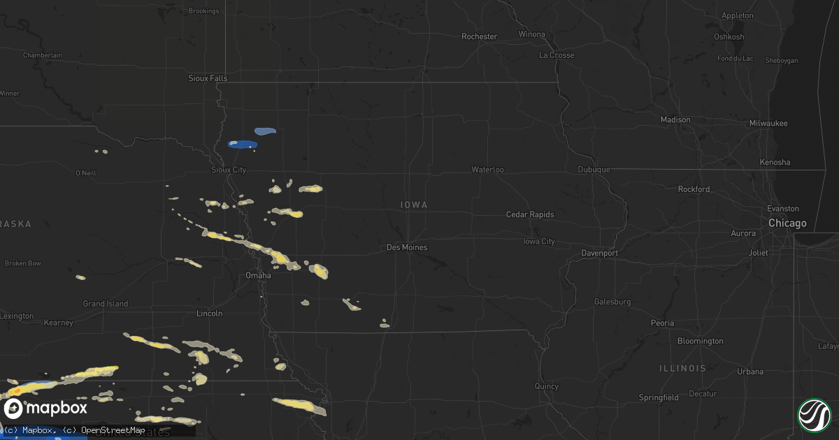
Hail Map in Iowa on August 5, 2023
Get this storm
August 5 map
$229
one time, instant access
Download today. No call, no setup
Keep the $229
Bought the map and want the full workflow? Apply the entire $229 to a subscription within 7 days. None of it is wasted.
Every map, not just this one
This buys you this map. Subscription and you get every map we run, in the markets you choose from a few cities to whole states to nationwide. Plus real-time alerts the moment a storm fires.
Contact data
Name, contact info, occupancy, even credit band for addresses in the footprint. You go from where it hit to who to call.
Become the source they trust
Unlimited branding weather history reports on demand. You already have the documented answer ready for the property owner, and you are the one who showed up with it.
Property data and RoofTrace estimates
Pull up any address you have got, its value and the exact code rules for that jurisdiction, straight from One Click Code. Then RoofTrace estimates the squares, pitch, and roof value, priced the way you price.
Storm reports in Iowa
Iowa
| Date | Description |
|---|---|
| 08/05/20236:25 PM CDT | Awos station klrj le mars airport. |
| 08/05/20232:36 PM CDT | Reported by iowa state patrol: sioux center fire reported tornado on the ground 2.5 sw of sioux center. |
| 08/05/20232:30 PM CDT | Social media report with picture of tornado south of sioux center ia. 1 mile east of highway 75 on highway 10 looking southwest. |
| 08/04/20239:53 PM CDT | Tree blown down and blocking highway 175 in lake city. |
| 08/04/20239:45 PM CDT | Trees down south of bennett access. Time estimated with radar. |
| 08/04/20239:33 PM CDT | Reports of trees and a powerline down in the city of carroll. |
| 08/04/20239:33 PM CDT | Building structure damaged. Time estimated by radar. Delayed report. |
| 08/04/20239:31 PM CDT | Tree damage near us71. |
| 08/04/20239:30 PM CDT | Outbuilding damaged... Portions blown into field. Delayed report. Time estimated by radar. |
| 08/04/20239:27 PM CDT | Semi trailer blown over near the intersection of highway 71 and 110th st. Time estimated from radar. |
| 08/04/20239:05 PM CDT | Quarter size hail. Tree blown on highway 59 blocking traffic in both directions. |
All States Impacted by Hail Map on August 5, 2023
Cities Impacted by Hail Map on August 5, 2023
- Cedar Vale, KS
- Bartlesville, OK
- Barnsdall, OK
- Pawhuska, OK
- Shidler, OK
- Sedan, KS
- Ochelata, OK
- Chautauqua, KS
- Copan, OK
- Peru, KS
- S Coffeyville, OK
- Caney, KS
- Wann, OK
- Dewey, OK
- Ramona, OK
- Dearing, KS
- Niotaze, KS
- Havana, KS
- Independence, KS
- Lenapah, OK
- Delaware, OK
- Tyro, KS
- Coffeyville, KS
- Nowata, OK
- Kanorado, KS
- Burlington, CO
- Goodland, KS
- Murray, KY
- Hazel, KY
- Stratton, CO
- Bethune, CO
- Eureka Springs, AR
- Booker, TX
- Peyton, CO
- Elbert, CO
- Kiowa, CO
- Calhan, CO
- Ramah, CO
- Friona, TX
- Hereford, TX
- Summerfield, TX
- Colorado Springs, CO
- Monument, CO
- Palmer Lake, CO
- Simla, CO
- Agate, CO
- Usaf Academy, CO
- Dimmitt, TX
- Amarillo, TX
- Limon, CO
- Fountain, CO
- Rush, CO
- Yoder, CO
- Earth, TX
- Claude, TX
- Springlake, TX
- Genoa, CO
- Woodrow, CO
- Lindon, CO
- Anton, CO
- Boone, CO
- Yuma, CO
- Ordway, CO
- Sudan, TX
- Amherst, TX
- Littlefield, TX
- Eckley, CO
- Vernon, CO
- Wray, CO
- Olney Springs, CO
- Crowley, CO
- Fowler, CO
- Saint Francis, KS
- Manzanola, CO
- Rocky Ford, CO
- Sugar City, CO
- La Junta, CO
- Merrill, IA
- Akron, IA
- Le Mars, IA
- Brunsville, IA
- Marcus, IA
- Remsen, IA
- Alton, IA
- Granville, IA
- Paullina, IA
- Oyens, IA
- Kim, CO
- Pritchett, CO
- Selden, KS
- Oberlin, KS
- Jennings, KS
- Dresden, KS
- Hughes, AR
- Leachville, AR
- Alvord, TX
- Sunset, TX
- Chico, TX
- Ellsworth, ME
- Aurora, ME
- Nunn, CO
- Carr, CO
- Bryant, AR
- Benton, AR
- Alexander, AR
- Akron, CO
- Onawa, IA
- Whiting, IA
- Cotton Plant, AR
- Little Rock, AR
- Brownsville, TN
- Brinkley, AR
- Grand Junction, TN
- Cobden, IL
- Alto Pass, IL
- Grover, CO
- Loveland, CO
- Brewton, AL
- Oakland, TN
- Somerville, TN
- Milton, FL
- Crestview, FL
- Dexter, MO
- Dudley, MO
- Macy, NE
- Lonsdale, AR
- Carlisle, AR
- Williston, TN
- Lynch, NE
- Verdigre, NE
- Hot Springs National Park, AR
- Story, AR
- Panhandle, TX
- Butler, AL
- Moscow, TN
- Wing, AL
- Toxey, AL
- Attapulgus, GA
- Gainestown, AL
- Jackson, AL
- Miramar Beach, FL
- Destin, FL
- Santa Rosa Beach, FL
- Earle, AR
- Parkin, AR
- Drummonds, TN
- Cardwell, MO
- Alamo, TN
- Scott, AR
- Malvern, AR
- Lonoke, AR
- Molino, FL
- Perdido, AL
- Laurel Hill, FL
- Wynne, AR
- McDavid, FL
- Luxora, AR
- Bells, TN
- Bernie, MO
- Cape Girardeau, MO
- McClure, IL
- Niceville, FL
- Fort Collins, CO
- New Madrid, MO
- Cantonment, FL
- Blytheville, AR
- Manila, AR
- Rose Hill, MS
- West Terre Haute, IN
- Inlet Beach, FL
- Halls, TN
- Eglin Afb, FL
- Jessieville, AR
- Broken Bow, OK
- Kennett, MO
- Hornersville, MO
- Senath, MO
- Mobile, AL
- Widener, AR
- Forrest City, AR
- Hull, IA
- Boyden, IA
- Mabelvale, AR
- Dell, AR
- Osceola, AR
- Ripley, TN
- Paron, AR
- Hot Springs Village, AR
- Eads, TN
- East Prairie, MO
- Dover Foxcroft, ME
- Woodland Park, CO
- Fort Walton Beach, FL
- Munford, TN
- Wilson, AR
- Rossville, TN
- Arlington, TN
- Memphis, TN
- Atoka, TN
- Millington, TN
- Climax, GA
- Hickman, KY
- Model, CO
- Clayton, KS
- Norcatur, KS
- Norton, KS
- Campo, CO
- Springfield, CO
- Almena, KS
- Prairie View, KS
- Long Island, KS
- Phillipsburg, KS
- Boise City, OK
- Riverton, NE
- Inavale, NE
- Red Cloud, NE
- Keyes, OK
- Morland, KS
- Penokee, KS
- Hill City, KS
- Bogue, KS
- Agra, KS
- Damar, KS
- Palco, KS
- Stockton, KS
- Plainville, KS
- Winona, KS
- Oakley, KS
- Grinnell, KS
- Gove, KS
- Healy, KS
- Dighton, KS
- Utica, KS
- Beeler, KS
- Guide Rock, NE
- Trinidad, CO
- Branson, CO
- Woodston, KS
- Superior, NE
- Texhoma, OK
- Dalhart, TX
- Matheson, CO
- Hugo, CO
- Natoma, KS
- Alton, KS
- Osborne, KS
- Paradise, KS
- Waldo, KS
- Lucas, KS
- Goodwell, OK
- Stratford, TX
- Karval, CO
- Cactus, TX
- Dumas, TX
- Sunray, TX
- Rush Center, KS
- La Crosse, KS
- Nekoma, KS
- Rozel, KS
- Bison, KS
- Otis, KS
- Albert, KS
- Hoisington, KS
- Larned, KS
- Olmitz, KS
- Great Bend, KS
- Claflin, KS
- Pawnee Rock, KS
- Ellinwood, KS
- Bushton, KS
- Kit Carson, CO
- Stinnett, TX
- Raymond, KS
- Chase, KS
- Hudson, KS
- St John, KS
- Lyons, KS
- Sylvia, KS
- Alden, KS
- Inman, KS
- Windom, KS
- Sterling, KS
- Little River, KS
- Abbyville, KS
- Nickerson, KS
- Wild Horse, CO
- Burrton, KS
- Haven, KS
- Hutchinson, KS
- Halstead, KS
- Buhler, KS
- Partridge, KS
- South Hutchinson, KS
- Moundridge, KS
- Newton, KS
- Valley Center, KS
- Colwich, KS
- Mount Hope, KS
- Sedgwick, KS
- Bentley, KS
- Geneseo, KS
- Marquette, KS
- Galva, KS
- Hesston, KS
- Mcpherson, KS
- Roxbury, KS
- Lehigh, KS
- Canton, KS
- Hillsboro, KS
- Durham, KS
- Goessel, KS
- Andale, KS
- Morse, TX
- Borger, TX
- Skellytown, TX
- Pampa, TX
- Miami, TX
- Walton, KS
- North Newton, KS
- Florence, KS
- Marion, KS
- Peabody, KS
- Maize, KS
- Whitewater, KS
- Kechi, KS
- Mcconnell Afb, KS
- Derby, KS
- Benton, KS
- Elbing, KS
- Andover, KS
- Burns, KS
- Potwin, KS
- Greenwich, KS
- Wichita, KS
- Cassoday, KS
- Augusta, KS
- Cottonwood Falls, KS
- Towanda, KS
- Rose Hill, KS
- El Dorado, KS
- Cedar Point, KS
- Mulvane, KS
- Elmdale, KS
- Matfield Green, KS
- Goddard, KS
- Leon, KS
- Rosalia, KS
- Eureka, KS
- Olpe, KS
- Palisade, NE
- Shelley, ID
- Idaho Falls, ID
- Stanton, NE
- Spencer, IN
- Wallace, KS
- Bancroft, NE
- Pender, NE
- Randolph, NE
- Hamilton, AL
- Denison, IA
- Sharon Springs, KS
- Geneva, NE
- Edgar, NE
- Sutton, NE
- Beaverton, AL
- Lake View, IA
- Odebolt, IA
- Kiron, IA
- Wall Lake, IA
- Knoxville, AL
- Eutaw, AL
- Macon, MS
- Battle Creek, IA
- Correctionville, IA
- Charter Oak, IA
- Ute, IA
- Dow City, IA
- Arion, IA
- Soldier, IA
- Nunnelly, TN
- Lyles, TN
- Shuqualak, MS
- Brady, NE
- Maxwell, NE
- Preston, MS
- Otis, CO
- Maple, TX
- Morton, TX
- New Raymer, CO
- Briggsdale, CO
- Fort Morgan, CO
- Oneill, NE
- Rosalie, NE
- Jackson, TN
- Beech Bluff, TN
- Beatrice, NE
- Plymouth, NE
- De Witt, NE
- Ellis, KS
- Fulton, MS
- Walsh, CO
- Benkelman, NE
- Parks, NE
- Max, NE
- Haigler, NE
- Lenora, KS
- Kensington, KS
- Gordo, AL
- Berthoud, CO
- Freeport, FL
- Kenton, OK
- Grenville, NM
- Mankato, KS
- Esbon, KS
- Burr Oak, KS
- Mountain City, NV
- Prague, NE
- Linwood, NE
- Decatur, NE
- Henderson, TN
- Pinson, TN
- Loretto, TN
- West Point, NE
- Scribner, NE
- Neola, IA
- Missouri Valley, IA
- Modale, IA
- Persia, IA
- Blair, NE
- Herman, NE
- Logan, IA
- Odell, NE
- Hanover, KS
- Hollenberg, KS
- Bremen, KS
- Danbury, IA
- Merino, CO
- Stoneham, CO
- Craig, NE
- Hooper, NE
- Bethel Springs, TN
- Hornsby, TN
- Rogers, NE
- Glade, KS
- Jamestown, KS
- Johnstown, CO
- Jonesboro, IL
- Hackleburg, AL
- Booneville, MS
- Medicine Lodge, KS
- Wisner, NE
- Pilger, NE
- Idalia, CO
- Tamms, IL
- Thebes, IL
- Concordia, KS
- Schuyler, NE
- David City, NE
- Saulsbury, TN
- Shickley, NE
- Tremont, MS
- Ogallah, KS
- Wakeeney, KS
- Bird City, KS
- Farwell, NE
- Portales, NM
- Pep, NM
- Crab Orchard, NE
- Filley, NE
- Mullinville, KS
- Sulligent, AL
- Clay Center, NE
- Luray, TN
- Ault, CO
- Boligee, AL
- McDonald, KS
- Atwood, KS
- Poland, IN
- Huron, TN
- Pickrell, NE
- Swanton, NE
- Cortland, NE
- Wilber, NE
- Clatonia, NE
- Lebanon, TN
- Mount Juliet, TN
- Carrollton, AL
- Aliceville, AL
- Tekamah, NE
- Ullin, IL
- Scott City, MO
- Saint Joseph, TN
- Killen, AL
- Iron City, TN
- Western, NE
- Daykin, NE
- Ohiowa, NE
- Strang, NE
- Milligan, NE
- Saronville, NE
- Tobias, NE
- Walthill, NE
- Cheraw, CO
- Clyde, KS
- Clifton, KS
- Washington, KS
- Fairview, TN
- Bloomington, NE
- Stratton, NE
- Joes, CO
- Kirk, CO
- Lebanon, KS
- Smith Center, KS
- Moorhead, IA
- Elwood, IN
- Tipton, IN
- Atlanta, IN
- Bolivar, TN
- Cope, CO
- Ida Grove, IA
- Herndon, KS
- Monument, KS
- Cherokee, AL
- Iuka, MS
- Diller, NE
- Flagler, CO
- Arriba, CO
- Evergreen, AL
- Andalusia, AL
- Burchard, NE
- Detroit, AL
- Winside, NE
- Hoskins, NE
- Dunlap, IA
- Brilliant, AL
- Guin, AL
- Gilbertsville, KY
- Benton, KY
- Symsonia, KY
- Calvert City, KY
- De Kalb, MS
- Wolf Lake, IL
- Medon, TN
- Finger, TN
- Elida, NM
- Morrowville, KS
- Corinth, MS
- Glen, MS
- Burnsville, MS
- Haviland, KS
- Protection, KS
- Red Bay, AL
- Russellville, AL
- Winfield, AL
- Rogers, NM
- Oakland, NE
- Uehling, NE
- Dodge, NE
- Haddam, KS
- Linn, KS
- Adams, NE
- Spruce Pine, AL
- Phil Campbell, AL
- Hodges, AL
- Narka, KS
- Seminole, AL
- Green, KS
- Rienzi, MS
- Tishomingo, MS
- Mantachie, MS
- Bear Creek, AL
- Golden, MS
- Haleyville, AL
- Vina, AL
- Scooba, MS
- Emelle, AL
- Attica, KS
- Lincoln, ME
- Ashton, NE
- Pulaski, IL
- Louisville, MS
- Sturgis, MS
- Uriah, AL
- Hoxie, KS
- Lamar, CO
- Mercer, TN
- Columbus, NE
- Florence, AL
- Lexington, AL
- Sloan, IA
- Columbus, MS
- Falkner, MS
- Ripley, MS
- Paducah, KY
- Brookport, IL
- Ledbetter, KY
- Grand Chain, IL
- Las Animas, CO
- Republican City, NE
- Minneola, KS
- Bucklin, KS
- Howells, NE
- Clay Center, KS
- Morganville, KS
- Aurora, KS
- Dickson, TN
- Hubbell, NE
- Reynolds, NE
- Eagle Lake, ME
- Mason, TN
- Wakefield, NE
- Snyder, CO
- Severy, KS
- Piedmont, KS
- Hamilton, KS
- Madison, KS
- Emporia, KS
- Hartford, KS
- Neosho Rapids, KS
- Virgil, KS
- Fall River, KS
- Toronto, KS
- Neal, KS
- Howard, KS
- Iona, ID
- Gridley, KS
- Burlington, KS
- Yates Center, KS
- Fredonia, KS
- Neosho Falls, KS
- Waverly, KS
- Lebo, KS
- Buffalo, KS
- Le Roy, KS
- Westphalia, KS
- Humboldt, KS
- Chanute, KS
- Piqua, KS
- Iola, KS
- Benedict, KS
- Colony, KS
- Warner, OK
- Alva, OK
- Burlington, OK
- Shubert, NE
- Nemaha, NE
- Hancock, IA
- Oakland, IA
- Walnut, MS
- Powhattan, KS
- Robinson, KS
- Denton, KS
- Everest, KS
- Horton, KS
- Hiawatha, KS
- Okmulgee, OK
- Haskell, OK
- Savannah, TN
- Council Bluffs, IA
- Underwood, IA
- McClelland, IA
- Medford, OK
- Deer Creek, OK
- Nardin, OK
- Falls City, NE
- Verdon, NE
- Carmen, OK
- Aline, OK
- Ramer, TN
- Michie, TN
- Guys, TN
- Hays, KS
- Tecumseh, NE
- Steinauer, NE
- Fayette, AL
- Berry, AL
- Bankston, AL
- Alexander, KS
- Bazine, KS
- Ness City, KS
- Auburn, IA
- Vona, CO
- Seibert, CO
- Coldwater, KS
- Wilmore, KS
- Epes, AL
- Gainesville, AL
- Pocahontas, TN
- Middleton, TN
- Nashville, KS
- Zenda, KS
- Vossburg, MS
- Mounds, OK
- Beggs, OK
- Logan, KS
- Wakita, OK
- Anthony, KS
- Waldron, KS
- Bluff City, KS
- Amorita, OK
- Manchester, OK
- Agenda, KS
- Minden, IA
- Avoca, IA
- Shelby, IA
- Hickory Valley, TN
- Shiloh, TN
- Counce, TN
- Selmer, TN
- Stantonville, TN
- Adamsville, TN
- Crump, TN
- Lamont, OK
- Blackwell, OK
- Tonkawa, OK
- McCracken, KS
- Ralston, OK
- Walnut, IA
- Randolph, KS
- Milnesand, NM
- Webbers Falls, OK
- Porum, OK
- Jewell, KS
- Ashland, KS
- Hopkinsville, KY
- Herndon, KY
- Cadiz, KY
- Troy, KS
- Atchison, KS
- Bendena, KS
- Tiplersville, MS
- Carbon Hill, AL
- Steele City, NE
- Atlantic, IA
- Lewis, IA
- Cumberland, IA
- Griswold, IA
- Dacoma, OK
- Cherokee, OK
- Wiota, IA
- Fowler, KS
- Isabel, KS
- Sawyer, KS
- Manilla, IA
- Michigan City, MS
- Lake City, KS
- Plattsmouth, NE
- Palmer, KS
- Pawnee, OK
- Hardtner, KS
- Morris, OK
- Harper, KS
- Danville, KS
- Northport, AL
- Glencoe, OK
- Stigler, OK
- Beaver Dam, KY
- Eufaula, OK
- Kuttawa, KY
- Coats, KS
- Brownell, KS
- Stanton, IA
- Red Oak, IA
- Fairview, KS
- Ashland, MS
- Nash, OK
- Jet, OK
- Hendley, NE
- Beaver City, NE
- Argonia, KS
- Baileyville, KS
- Gruver, TX
- Greenwood Springs, MS
- Tompkinsville, KY
- Milan, KS
- Akron, AL
- La Grange, TN
- Mooreville, MS
- Tupelo, MS
- Quinton, OK
- Mcalester, OK
- Buffalo, OK
- Rosston, OK
- Cromwell, KY
- Morgantown, KY
- Sterling, NE
- Elk Creek, NE
- Checotah, OK
- Pulaski, TN
- Freedom, OK
- Kellerton, IA
- Davis City, IA
- Lamoni, IA
- Hackett, AR
- Fort Smith, AR
- Prospect, TN
- Corning, IA
- Prescott, IA
- Clearfield, IA
- Diagonal, IA
- Lenox, IA
- Muldrow, OK
- Keota, OK
- South Pittsburg, TN
- Garnett, KS
- Elkmont, AL
- Helena, OK
- Lancaster, KS
- Greenwood, AR
- Sharon, KS
- Saint Joseph, MO
- De Kalb, MO
- Rushville, MO
- Grand River, IA
- Spiro, OK
- Pocola, OK
- Winston, MO
- Weatherby, MO
- Kidder, MO
- Gentry, MO
- Penrose, CO
- Oktaha, OK
- Bixby, OK
- Council Hill, OK
- Boynton, OK
- Charleston, AR
- Faucett, MO
- Wathena, KS
- Milton, KS
- Lavaca, AR
- Barling, AR
- Glenpool, OK
- Petersburg, TN
- Frankewing, TN
- Fayetteville, TN
- Goodspring, TN
- Ardmore, TN


