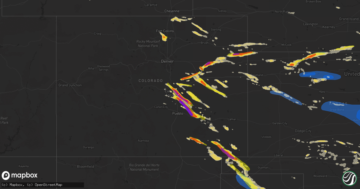
Hail Map on August 5, 2023
Get this storm
August 5 map
$229
one time, instant access
Download today. No call, no setup
Keep the $229
Bought the map and want the full workflow? Apply the entire $229 to a subscription within 7 days. None of it is wasted.
Every map, not just this one
This buys you this map. Subscription and you get every map we run, in the markets you choose from a few cities to whole states to nationwide. Plus real-time alerts the moment a storm fires.
Contact data
Name, contact info, occupancy, even credit band for addresses in the footprint. You go from where it hit to who to call.
Become the source they trust
Unlimited branding weather history reports on demand. You already have the documented answer ready for the property owner, and you are the one who showed up with it.
Property data and RoofTrace estimates
Pull up any address you have got, its value and the exact code rules for that jurisdiction, straight from One Click Code. Then RoofTrace estimates the squares, pitch, and roof value, priced the way you price.
States Impacted by Hail Map on August 5, 2023
Storm reports
Arkansas
| Date | Description |
|---|---|
| 08/05/20233:20 PM CDT | Large tree uprooted in burdette. |
| 08/05/202310:30 AM CDT | Uprooted trees and numerous branches down. Pics relayed via social media. Time estimated from radar. |
| 08/05/20239:50 AM CDT | Large tree snapped at base of trunk. Pic relayed via social media. Time estimated from radar. |
Texas
| Date | Description |
|---|---|
| 08/05/20234:05 PM CDT | Report from mping: quarter |
| 08/05/20234:05 PM CDT | A local report indicates 1.00 inch wind near 1 W Amarillo |
| 08/05/20234:02 PM CDT | Photo submitted via social media. |
| 08/05/20234:00 PM CDT | A local report indicates 1.00 inch wind near 5 W Amarillo |
| 08/05/20233:55 PM CDT | A local report indicates 1.00 inch wind near 3 W Amarillo |
| 08/05/20233:55 PM CDT | A local report indicates 1.00 inch wind near 3 WSW Amarillo |
| 08/05/20233:54 PM CDT | A local report indicates 1.00 inch wind near 4 WSW Amarillo |
| 08/05/20233:53 PM CDT | Photo submitted via social media. |
| 08/05/20233:46 PM CDT | Report from mping: quarter |
| 08/05/20233:44 PM CDT | Report from mping: half dollar |
| 08/04/202310:51 PM CDT | Observed by mesonet. |
| 08/04/202310:48 PM CDT | Measured by mesonet. A 62 mph wind gust was observed at 10:47pm. |
| 08/04/202310:16 PM CDT | Mesonet gusted to 67 mph at 10:08pm followed by a 59 mph at 10:09pm... Then dropped below severe limits. A 66 mph gust was observed at 10:13pm and peaked at 71 mph at 1 |
| 08/04/20239:40 PM CDT | Picture sent in to facebook. Time estimated from radar. |
| 08/04/20239:35 PM CDT | Corrects previous tstm wnd gst report from 4 wnw stratford. A 61 mph wind gust was observed at 9:29pm. Gusts weakened until the 78 mph gust at 9:35pm. A 66 mph gust occ |
Nebraska
| Date | Description |
|---|---|
| 08/05/20236:14 PM CDT | Weatherlink site brunswig shop. |
| 08/04/202311:15 PM CDT | Large tree branches broken. Pictures of the damage received via social media. |
| 08/04/202310:29 PM CDT | Measured from a private weather station. |
| 08/04/202310:17 PM CDT | Delayed report of 12-14 inch diameter tree and fence blown over. Time estimated from radar. |
| 08/04/20238:33 PM CDT | Range from pea to quarter sized hail. Time estimated from radar. |
| 08/04/20238:00 PM CDT | Public report of nickel to quarter size hail. Location estimated. |
| 08/04/20237:55 PM CDT | Hail up to quarter size...most smaller. |
| 08/04/20237:53 PM CDT | Report relayed from local official... Time estimated from radar data. |
Mississippi
| Date | Description |
|---|---|
| 08/05/20235:51 PM CDT | Quarter sized hail fell in fulton. Size is estimated |
| 08/05/20235:48 PM CDT | Tree down in dorsey |
Maine
| Date | Description |
|---|---|
| 08/05/20232:00 PM CDT | Estimated hail size from facebook photo. |
Indiana
| Date | Description |
|---|---|
| 08/05/20235:31 PM CDT | 8 inch diameter limbs and a tree are down across park ave between 13st and lafayette ave. Per ham network. |
Colorado
| Date | Description |
|---|---|
| 08/05/20236:05 PM CDT | A local report indicates 1.75 inch wind near Olney Springs |
| 08/05/20235:59 PM CDT | A local report indicates 1.75 inch wind near Fowler |
| 08/05/20235:40 PM CDT | Observer called in a report of hail between quarter to half-dollar in size. Hail was ongoing as of the call. |
| 08/05/20235:35 PM CDT | Trained spotter reports hail ping pong to golf ball size. |
| 08/05/20235:31 PM CDT | Trained spotter reports hail up to ping pong ball size. Started out as quarter size... Then went up to ping pong ball size. |
| 08/05/20235:30 PM CDT | Delayed report... Report of golf ball sized hail just north of vernon. |
| 08/05/20234:49 PM CDT | Report from mping: tennis ball |
| 08/05/20234:48 PM CDT | Report from mping: baseball+ |
| 08/05/20234:47 PM CDT | Report from mping: hen egg+ |
| 08/05/20234:46 PM CDT | Measured 3.3 inch hail with picture on social media. |
| 08/05/20234:45 PM CDT | Hail between 3 and 4 inches. |
| 08/05/20234:43 PM CDT | Several social media reports of dime to quarter size hail in loveland from lake loveland to centerra. Time and location estimated. |
| 08/05/20234:43 PM CDT | Report from mping: quarter |
| 08/05/20234:41 PM CDT | *** 1 inj *** social media report from lake loveland park. Estimated up to golf ball sized hail... Though most stones were smaller. One swimmer sustained a large welt/b |
| 08/05/20234:35 PM CDT | Relayed via social media. |
| 08/05/20234:31 PM CDT | A local report indicates 1.25 inch wind near 4 E Security |
| 08/05/20234:26 PM CDT | Report from mping: tennis ball |
| 08/05/20234:24 PM CDT | Delayed report via spotternetwork. Time estimated by radar. |
| 08/05/20234:23 PM CDT | A local report indicates 1.00 inch wind near 2 ESE Security |
| 08/05/20234:23 PM CDT | Report from mping: half dollar |
| 08/05/20234:14 PM CDT | Report from mping: baseball |
| 08/05/20234:08 PM CDT | Report from mping: tennis ball |
| 08/05/20234:05 PM CDT | A local report indicates 1.50 inch wind near 8 S Last Chance |
| 08/05/20234:00 PM CDT | A local report indicates 1.75 inch wind near 3 N Peterson AFB |
| 08/05/20234:00 PM CDT | Report from mping: ping pong ball |
| 08/05/20234:00 PM CDT | Report from mping: ping pong ball |
| 08/05/20233:59 PM CDT | Report from mping: golf ball |
| 08/05/20233:57 PM CDT | A local report indicates 2.00 inch wind near 3 NE Peterson AFB |
| 08/05/20233:57 PM CDT | A local report indicates 2.00 inch wind near 4 NE Peterson AFB |
| 08/05/20233:56 PM CDT | Report from mping: ping pong ball |
| 08/05/20233:53 PM CDT | Numerous reports of ping pong to golf ball size hail. |
| 08/05/20233:49 PM CDT | A local report indicates 1.75 inch wind near 4 WSW Falcon |
| 08/05/20233:46 PM CDT | Report from mping: golf ball |
| 08/05/20233:46 PM CDT | A local report indicates 1.50 inch wind near 2 SSW Falcon |
| 08/05/20233:45 PM CDT | Numerous reports of hail 1.00 to 1.5 inches in this immediate region. |
| 08/05/20233:40 PM CDT | A local report indicates 1.75 inch wind near 5 SSW Black Forest |
| 08/05/20233:38 PM CDT | A local report indicates 1.25 inch wind near 3 E Air Force Academy |
| 08/05/20233:35 PM CDT | Pictures relayed via broadcast media. |
| 08/05/20233:27 PM CDT | Report from mping: half dollar |
| 08/05/20233:22 PM CDT | Report from mping: quarter |
| 08/05/20233:22 PM CDT | A local report indicates 1.00 inch wind near 3 ESE Air Force Academy |
| 08/05/20233:20 PM CDT | Located on i-25... Just north of air force academy. |
| 08/05/20233:15 PM CDT | Spotter reported visually seeing a funnel cloud within the past 5 minutes towards the northeast near black forest. |
| 08/05/20233:15 PM CDT | A local report indicates 1.00 inch wind near 2 SSE Air Force Academy |
| 08/05/20233:13 PM CDT | Report from mping: half dollar |
| 08/05/20233:10 PM CDT | Spotter can visually see a funnel cloud to the northeast of location... Just east of monument... Near black forest. |
| 08/05/20233:03 PM CDT | Spotter can visually see a funnel cloud to the west beginning to appear... Just north of monument. |
| 08/05/20233:00 PM CDT | A local report indicates 1.00 inch wind near 13 NNW Simla |
| 08/05/20232:43 PM CDT | Social media report of up to 2 inch diameter hail on county road 102 east of elbert. Time and location estimated by radar. |
| 08/05/20232:40 PM CDT | Spotter can visually see tornado on the ground about 3 to 4 miles north of their location. |
| 08/05/20232:37 PM CDT | Report via social media... With photos of roughly ping pong to golf ball size hail. Time estimated by radar. |
| 08/05/20232:30 PM CDT | A local report indicates 1.00 inch wind near 5 N Peyton |
| 08/04/20239:31 PM CDT | Hail lasted approximately 15 minutes. |
| 08/04/20239:19 PM CDT | A local report indicates 1.25 inch wind near 8 ENE Matheson |
| 08/04/20238:54 PM CDT | Report from mping: quarter |
| 08/04/20238:50 PM CDT | Social media report. Two trees uprooted on high plains blvd with a corn field flattened to the west. Time estimated by radar. |
| 08/04/20237:20 PM CDT | Weatherlink. |
| 08/04/20237:14 PM CDT | Winds came from the back side of the thunderstorm as the storm was moving southeast. |
| 08/04/20237:10 PM CDT | Pictures via social media. |
Idaho
| Date | Description |
|---|---|
| 08/04/202310:25 PM CDT | Quarter-sized hail...some were larger. |
Florida
| Date | Description |
|---|---|
| 08/05/20232:16 PM CDT | Tree down near carson oaks ln and mack bayou road. |
| 08/05/20232:16 PM CDT | Report from mping: 1-inch tree limbs broken; shingles blown off. |
Iowa
| Date | Description |
|---|---|
| 08/05/20236:25 PM CDT | Awos station klrj le mars airport. |
| 08/05/20232:36 PM CDT | Reported by iowa state patrol: sioux center fire reported tornado on the ground 2.5 sw of sioux center. |
| 08/05/20232:30 PM CDT | Social media report with picture of tornado south of sioux center ia. 1 mile east of highway 75 on highway 10 looking southwest. |
| 08/04/20239:53 PM CDT | Tree blown down and blocking highway 175 in lake city. |
| 08/04/20239:45 PM CDT | Trees down south of bennett access. Time estimated with radar. |
| 08/04/20239:33 PM CDT | Reports of trees and a powerline down in the city of carroll. |
| 08/04/20239:33 PM CDT | Building structure damaged. Time estimated by radar. Delayed report. |
| 08/04/20239:31 PM CDT | Tree damage near us71. |
| 08/04/20239:30 PM CDT | Outbuilding damaged... Portions blown into field. Delayed report. Time estimated by radar. |
| 08/04/20239:27 PM CDT | Semi trailer blown over near the intersection of highway 71 and 110th st. Time estimated from radar. |
| 08/04/20239:05 PM CDT | Quarter size hail. Tree blown on highway 59 blocking traffic in both directions. |
Illinois
| Date | Description |
|---|---|
| 08/05/20235:30 PM CDT | Brief |
Kansas
| Date | Description |
|---|---|
| 08/05/202311:55 AM CDT | A local report indicates 60 MPH wind near Wamego |
| 08/05/202311:23 AM CDT | 2 foot diameter tree branch down. |
| 08/05/20237:52 AM CDT | A local report indicates 65 MPH wind near Tyro |
| 08/05/20237:52 AM CDT | 2-3 inch tree limbs down in town. |
| 08/05/20237:20 AM CDT | A local report indicates 60 MPH wind near Sedan |
| 08/05/20231:30 AM CDT | 8 inch tree limbs down as well as many 4 to 5 inch tree limbs broken off. |
| 08/05/20231:16 AM CDT | A local report indicates 59 MPH wind near Chanute |
| 08/05/202312:53 AM CDT | Kfoe. |
| 08/05/202312:31 AM CDT | A local report indicates 60 MPH wind near Eureka |
| 08/05/202312:29 AM CDT | A local report indicates 72 MPH wind near 2 N Eureka |
| 08/05/202312:27 AM CDT | Damaged power pole at the north end of the city; some power outages in the area. Also a report of a tree down on the west side of el dorado |
| 08/05/202312:21 AM CDT | A local report indicates 63 MPH wind near 4 E Matfield Green |
| 08/05/202312:15 AM CDT | A local report indicates 73 MPH wind near 1 W El Dorado |
| 08/05/202312:02 AM CDT | Power outage. |
| 08/05/202312:02 AM CDT | Lines down... Poles on fire in wichita metro area. |
| 08/04/202311:58 PM CDT | Corrects previous tstm wnd dmg report from potwin. |
| 08/04/202311:55 PM CDT | Vehicle accident on us 50 and rock road. |
| 08/04/202311:54 PM CDT | Several branches down. |
| 08/04/202311:51 PM CDT | Northbound lane of i-135 blocked due to vehicle accident in vicinity of highway 50 exit... Vicinity of rest area. |
| 08/04/202311:51 PM CDT | A local report indicates 61 MPH wind near 3 ESE Bel Aire |
| 08/04/202311:50 PM CDT | Personal weather station measured 62 mph gust. |
| 08/04/202311:45 PM CDT | Delayed report. Time based on radar. |
| 08/04/202311:45 PM CDT | Corrects previous tstm wnd dmg report from 4 s maize. Delayed report. Time based on radar. Approximately 12 inch diameter tree branch downed. |
| 08/04/202311:41 PM CDT | A local report indicates 70 MPH wind near Newton |
| 08/04/202311:39 PM CDT | A local report indicates 70 MPH wind near 1 E Sedgwick |
| 08/04/202311:37 PM CDT | A local report indicates 70 MPH wind near Goessel |
| 08/04/202311:31 PM CDT | Personal weather station measured wind gust. |
| 08/04/202311:28 PM CDT | Delayed report of an uprooted tree in hesston. Received via social media and the report time was estimated via radar. |
| 08/04/202311:26 PM CDT | Delayed report via social media of a tree trunk nearly completely snapped. Health of the tree is unknown. Time of the report was estimated via radar. |
| 08/04/202311:25 PM CDT | Corrects previous tstm wnd dmg report from mount hope. |
| 08/04/202311:23 PM CDT | Extremely high winds in the city of mcpherson right now. Several locations without power 11:24 we have downed power lines at avenue a and main street in the city of mcp |
| 08/04/202311:23 PM CDT | Extremely high winds in the city of mcpherson right now. Several locations without power 11:24 we |
| 08/04/202311:20 PM CDT | 2 foot diameter tree branch down. |
| 08/04/202311:18 PM CDT | A local report indicates 80 MPH wind near Mcpherson |
| 08/04/202311:16 PM CDT | Estimated 60-70 mph. |
| 08/04/202311:15 PM CDT | 70+ estimated wind gusts north central part of hutchinson- north of fairgrounds. Power is out. No hail... Heavy rain & strong winds continue. Some large tree damage . |
| 08/04/202311:15 PM CDT | A local report indicates 63 MPH wind near Mcpherson Airport |
| 08/04/202311:15 PM CDT | Large tree limbs down... Size was 4 to 5 inch limbs which caused some roof damage to a home. |
| 08/04/202311:14 PM CDT | Delayed report via social media of 4 to 5 inch diameter tree limbs snapped. Time estimated via radar. |
| 08/04/202311:13 PM CDT | A local report indicates 74 MPH wind near Hutchinson |
| 08/04/202311:10 PM CDT | Personal weather station. |
| 08/04/202311:10 PM CDT | Personal weather station. |
| 08/04/202311:06 PM CDT | A local report indicates 60 MPH wind near 6 SW Hutchinson |
| 08/04/202311:06 PM CDT | Personal weather station. |
| 08/04/202311:05 PM CDT | Power flickering and heavy rain and very strong winds and down tree. |
| 08/04/202310:56 PM CDT | Trees coming down. |
| 08/04/202310:48 PM CDT | A local report indicates 60 MPH wind near Sterling |
| 08/04/202310:40 PM CDT | Corrects previous tstm wnd gst report from 5 n silica. Corrects previous tstm wnd gst report from 6 nnw silica. |
| 08/04/202310:27 PM CDT | 55 to 60 mph. |
| 08/04/202310:21 PM CDT | A local report indicates 60 MPH wind near Hoisington |
| 08/04/202310:17 PM CDT | A local report indicates 61 MPH wind near Great Bend Airport |
| 08/04/20239:22 PM CDT | Unofficial personal station. |
| 08/04/20239:18 PM CDT | Unofficial weather station. |
| 08/04/20239:16 PM CDT | Unofficial weather station. |
| 08/04/20239:16 PM CDT | Unofficial weather station. |
| 08/04/20239:06 PM CDT | Unofficial weather station. |
| 08/04/20239:05 PM CDT | A local report indicates 64 MPH wind near 6 SSW Stockton |
| 08/04/20238:59 PM CDT | Unofficial weather station. |
| 08/04/20238:38 PM CDT | Estimated 80-90 mph wind gusts in town. Reported a roaring sound with the wind. |
| 08/04/20238:35 PM CDT | A power pole was broken at cr n and hwy 283. Estimated time of report. |
| 08/04/20238:31 PM CDT | A local report indicates 72 MPH wind near 1 NE Hill City |
| 08/04/20238:30 PM CDT | Public report of estimated 60+ mph thunderstorm winds. |
| 08/04/20238:30 PM CDT | Public re |
| 08/04/20238:27 PM CDT | A local report indicates 59 MPH wind near 1 NE Hill City |
| 08/04/20238:23 PM CDT | Spotter estimated 65-70 mph wind gusts. |
| 08/04/20238:22 PM CDT | A local report indicates 64 MPH wind near Penokee |
| 08/04/20238:06 PM CDT | Unofficial personal station. |
| 08/04/20238:03 PM CDT | Also estimated 60 mph winds. |
| 08/04/20238:03 PM CDT | Estimated 60 mph winds. Also half dollar size hail. |
| 08/04/20238:00 PM CDT | *** 1 inj *** golf ball sized hail caused damage to a camper... Siding... And broke several windows in vehicles and the house. One person was hit in the head by hail an |
| 08/04/20237:50 PM CDT | Social media report of estimated 60mph wind gust. |
| 08/04/20237:44 PM CDT | Update from previous tstm wnd dmg report from almena. Report from a trained spotter of 6 to 8 inch tree limbs down. The spotter and another spotter also reported whole |
| 08/04/20237:44 PM CDT | Report from a trained spotter of 6 to 8 inch tree limbs down. The spotter and another spotter also reported whole trees down across town in almena. Some house and vehic |
| 08/04/20237:44 PM CDT | Delayed report... Spotter reported hail that was just below tennis ball in size. Time estimated from radar. |
| 08/04/20237:40 PM CDT | Corrects previous hail report from jennings. Several rounds of hail this size through :50 after. |
| 08/04/20237:30 PM CDT | Several rounds of hail this size through :40 after. |
| 08/04/20237:30 PM CDT | Delayed report via social media with photo of hailstones. Location estimated. |
| 08/04/20237:27 PM CDT | Report from mping: ping pong ball |
| 08/04/20237:25 PM CDT | A local report indicates 63 MPH wind near 3 N Colby |
| 08/04/20237:20 PM CDT | Trained spotter estimated wind gusts of 60-70 mph. |
| 08/04/20237:19 PM CDT | Social media report with picture of multiple golf ball sized hail stones. |
| 08/04/20237:15 PM CDT | Reported via weather underground kksatwoo3. |
| 08/04/20237:15 PM CDT | 6:15-20 pm mt estimated wind gusts of 50-60 mph. |
| 08/04/20237:00 PM CDT | Pea to sporadic golf ball sized hail. |
Oklahoma
| Date | Description |
|---|---|
| 08/05/20238:53 AM CDT | Large tree down. |
| 08/05/20237:44 AM CDT | Broadcast media reports tree uprooted... Pics relayed via social media. Time estimated from radar. |
| 08/05/20237:30 AM CDT | Measured at the wynona oklahoma mesonet. |
| 08/05/20231:55 AM CDT | Mesonet station mayr may ranch. |
Alabama
| Date | Description |
|---|---|
| 08/05/20236:57 PM CDT | Power lines across alabama highway 172 between hackleburg and hodges. |
| 08/05/20236:50 PM CDT | Report of a tree down near the 100 block of old natchez trace rd. Time estimated by radar. |
| 08/05/20236:30 PM CDT | Report of a tree down on power lines along highway 278 at brentwood dr. |
| 08/04/20239:35 PM CDT | Multiple trees down near salem. |
| 08/04/20239:26 PM CDT | Trees down near hwy 107 and cr 51. |
| 08/04/20239:05 PM CDT | Trees were knocked down in berlin. |
| 08/04/20238:24 PM CDT | Tree down on highway 17 near geiger. Another tree down on highway 116 between geiger and gainesville. Time estimated via radar. |
| 08/04/20238:16 PM CDT | Winston county sheriffs dispatch reported trees down on highway 278 close to the sipsey fork bridge. |
| 08/04/20237:50 PM CDT | Report of a tree down near river road and point road. Time estimated by radar. |
| 08/04/20237:49 PM CDT | Report of a tree down near spout springs rd and river rd. Time estimated by radar. |
| 08/04/20237:40 PM CDT | Emergency manager reports numerous trees down as well as power lines from russellville to phill campbell. Time estimated by radar. |
| 08/04/20237:40 PM CDT | Numerous trees down around natural bridge and lynn with power outages reported. |
| 08/04/20237:36 PM CDT | Social media photo of hail up to quarter size. Time estimated by radar. |
| 08/04/20237:35 PM CDT | Report of pole leaning or down near the 400 block of annapolis avenue. Time estimated by radar. |
| 08/04/20237:35 PM CDT | Storm spotter reports trees snapped or uprooted near the foresthill subdivision in florence. |
| 08/04/20237:35 PM CDT | Report of a tree down near the 300 block of north atlanta avenue. Time estimated by radar. |
| 08/04/20237:33 PM CDT | Report of a tree down near the 500 block of southeast 17th street. Time estimated by radar. |
| 08/04/20237:32 PM CDT | Tree and power lines down along county road 19 near highway 129. |
| 08/04/20237:30 PM CDT | Report of a tree down near north hook street. Time estimated by radar. |
| 08/04/20237:30 PM CDT | A social media report of a tree knocked onto a truck in downtown florence. |
| 08/04/20237:27 PM CDT | Report of a tree down near ridge pointe. |
| 08/04/20237:25 PM CDT | Report of a tree down near mt. Mills rd and highway 247. Time estimated by radar. |
| 08/04/20237:24 PM CDT | Corrects previous tstm wnd dmg report from 2 ene sheffield. Report of a tree down on the 1600 block of southern boulevard. Time estimated by radar. |
| 08/04/20237:22 PM CDT | Trees and power lines down along highways 44 and 129 on the southwest side of brilliant. |
| 08/04/20237:00 PM CDT | Report of a pole down or leaning near the 4000 block of cross lane. Time estimated by radar. |
Tennessee
| Date | Description |
|---|---|
| 08/05/20236:46 PM CDT | Tree and powerlines down on pyburns drive close to hwy 69. |
| 08/05/20235:58 PM CDT | Several trees down... Powerlines down... And light post snapped in half across hardeman co. |
| 08/05/20235:57 PM CDT | Trees and powerlines down in hornsby. |
| 08/05/20235:57 PM CDT | Reported tree fallen on house. |
| 08/05/20235:37 PM CDT | Power lines and a large tree down along highway 64. |
| 08/05/20235:25 PM CDT | Reported large tree down on highway 125 in bolivar... Tn. |
| 08/05/20235:21 PM CDT | Several trees down along highway 18 near medon. |
| 08/05/20235:16 PM CDT | Several utility poles were snapped along highway 76 just north of town. Large were downed as well. |
| 08/05/20235:15 PM CDT | Tree down blocking road east bound. |
| 08/05/20234:41 PM CDT | Several trees down. |
| 08/05/20234:40 PM CDT | Public reported tree down off chester st. |
| 08/05/20234:40 PM CDT | Several trees down across arlington. |
| 08/05/20234:40 PM CDT | Large tree uprooted in bartlett near memphis-arlington rd and venson dr. |
| 08/04/20237:34 PM CDT | Emergency manager reports a large tree across lexington highway |
| 08/04/20237:30 PM CDT | Adds to previous tstm wnd dmg report from 1 ssw saint joseph. Dispatch reports power lines down across us-43 approx 1 mile north of state line and numerous trees down o |
| 08/04/20237:30 PM CDT | Dispatch reports power lines down across us-43 approx 1 mile north of state line. |
Cities Impacted by Hail Map on August 5, 2023
- Cedar Vale, KS
- Bartlesville, OK
- Barnsdall, OK
- Pawhuska, OK
- Shidler, OK
- Sedan, KS
- Ochelata, OK
- Chautauqua, KS
- Copan, OK
- Peru, KS
- S Coffeyville, OK
- Caney, KS
- Wann, OK
- Dewey, OK
- Ramona, OK
- Dearing, KS
- Niotaze, KS
- Havana, KS
- Independence, KS
- Lenapah, OK
- Delaware, OK
- Tyro, KS
- Coffeyville, KS
- Nowata, OK
- Kanorado, KS
- Burlington, CO
- Goodland, KS
- Murray, KY
- Hazel, KY
- Stratton, CO
- Bethune, CO
- Eureka Springs, AR
- Booker, TX
- Peyton, CO
- Elbert, CO
- Kiowa, CO
- Calhan, CO
- Ramah, CO
- Friona, TX
- Hereford, TX
- Summerfield, TX
- Colorado Springs, CO
- Monument, CO
- Palmer Lake, CO
- Simla, CO
- Agate, CO
- Usaf Academy, CO
- Dimmitt, TX
- Amarillo, TX
- Limon, CO
- Fountain, CO
- Rush, CO
- Yoder, CO
- Earth, TX
- Claude, TX
- Springlake, TX
- Genoa, CO
- Woodrow, CO
- Lindon, CO
- Anton, CO
- Boone, CO
- Yuma, CO
- Ordway, CO
- Sudan, TX
- Amherst, TX
- Littlefield, TX
- Eckley, CO
- Vernon, CO
- Wray, CO
- Olney Springs, CO
- Crowley, CO
- Fowler, CO
- Saint Francis, KS
- Manzanola, CO
- Rocky Ford, CO
- Sugar City, CO
- La Junta, CO
- Merrill, IA
- Akron, IA
- Le Mars, IA
- Brunsville, IA
- Marcus, IA
- Remsen, IA
- Alton, IA
- Granville, IA
- Paullina, IA
- Oyens, IA
- Kim, CO
- Pritchett, CO
- Selden, KS
- Oberlin, KS
- Jennings, KS
- Dresden, KS
- Hughes, AR
- Leachville, AR
- Alvord, TX
- Sunset, TX
- Chico, TX
- Ellsworth, ME
- Aurora, ME
- Nunn, CO
- Carr, CO
- Bryant, AR
- Benton, AR
- Alexander, AR
- Akron, CO
- Onawa, IA
- Whiting, IA
- Cotton Plant, AR
- Little Rock, AR
- Brownsville, TN
- Brinkley, AR
- Grand Junction, TN
- Cobden, IL
- Alto Pass, IL
- Grover, CO
- Loveland, CO
- Brewton, AL
- Oakland, TN
- Somerville, TN
- Milton, FL
- Crestview, FL
- Dexter, MO
- Dudley, MO
- Macy, NE
- Lonsdale, AR
- Carlisle, AR
- Williston, TN
- Lynch, NE
- Verdigre, NE
- Hot Springs National Park, AR
- Story, AR
- Panhandle, TX
- Butler, AL
- Moscow, TN
- Wing, AL
- Toxey, AL
- Attapulgus, GA
- Gainestown, AL
- Jackson, AL
- Miramar Beach, FL
- Destin, FL
- Santa Rosa Beach, FL
- Earle, AR
- Parkin, AR
- Drummonds, TN
- Cardwell, MO
- Alamo, TN
- Scott, AR
- Malvern, AR
- Lonoke, AR
- Molino, FL
- Perdido, AL
- Laurel Hill, FL
- Wynne, AR
- McDavid, FL
- Luxora, AR
- Bells, TN
- Bernie, MO
- Cape Girardeau, MO
- McClure, IL
- Niceville, FL
- Fort Collins, CO
- New Madrid, MO
- Cantonment, FL
- Blytheville, AR
- Manila, AR
- Rose Hill, MS
- West Terre Haute, IN
- Inlet Beach, FL
- Halls, TN
- Eglin Afb, FL
- Jessieville, AR
- Broken Bow, OK
- Kennett, MO
- Hornersville, MO
- Senath, MO
- Mobile, AL
- Widener, AR
- Forrest City, AR
- Hull, IA
- Boyden, IA
- Mabelvale, AR
- Dell, AR
- Osceola, AR
- Ripley, TN
- Paron, AR
- Hot Springs Village, AR
- Eads, TN
- East Prairie, MO
- Dover Foxcroft, ME
- Woodland Park, CO
- Fort Walton Beach, FL
- Munford, TN
- Wilson, AR
- Rossville, TN
- Arlington, TN
- Memphis, TN
- Atoka, TN
- Millington, TN
- Climax, GA
- Hickman, KY
- Model, CO
- Clayton, KS
- Norcatur, KS
- Norton, KS
- Campo, CO
- Springfield, CO
- Almena, KS
- Prairie View, KS
- Long Island, KS
- Phillipsburg, KS
- Boise City, OK
- Riverton, NE
- Inavale, NE
- Red Cloud, NE
- Keyes, OK
- Morland, KS
- Penokee, KS
- Hill City, KS
- Bogue, KS
- Agra, KS
- Damar, KS
- Palco, KS
- Stockton, KS
- Plainville, KS
- Winona, KS
- Oakley, KS
- Grinnell, KS
- Gove, KS
- Healy, KS
- Dighton, KS
- Utica, KS
- Beeler, KS
- Guide Rock, NE
- Trinidad, CO
- Branson, CO
- Woodston, KS
- Superior, NE
- Texhoma, OK
- Dalhart, TX
- Matheson, CO
- Hugo, CO
- Natoma, KS
- Alton, KS
- Osborne, KS
- Paradise, KS
- Waldo, KS
- Lucas, KS
- Goodwell, OK
- Stratford, TX
- Karval, CO
- Cactus, TX
- Dumas, TX
- Sunray, TX
- Rush Center, KS
- La Crosse, KS
- Nekoma, KS
- Rozel, KS
- Bison, KS
- Otis, KS
- Albert, KS
- Hoisington, KS
- Larned, KS
- Olmitz, KS
- Great Bend, KS
- Claflin, KS
- Pawnee Rock, KS
- Ellinwood, KS
- Bushton, KS
- Kit Carson, CO
- Stinnett, TX
- Raymond, KS
- Chase, KS
- Hudson, KS
- St John, KS
- Lyons, KS
- Sylvia, KS
- Alden, KS
- Inman, KS
- Windom, KS
- Sterling, KS
- Little River, KS
- Abbyville, KS
- Nickerson, KS
- Wild Horse, CO
- Burrton, KS
- Haven, KS
- Hutchinson, KS
- Halstead, KS
- Buhler, KS
- Partridge, KS
- South Hutchinson, KS
- Moundridge, KS
- Newton, KS
- Valley Center, KS
- Colwich, KS
- Mount Hope, KS
- Sedgwick, KS
- Bentley, KS
- Geneseo, KS
- Marquette, KS
- Galva, KS
- Hesston, KS
- Mcpherson, KS
- Roxbury, KS
- Lehigh, KS
- Canton, KS
- Hillsboro, KS
- Durham, KS
- Goessel, KS
- Andale, KS
- Morse, TX
- Borger, TX
- Skellytown, TX
- Pampa, TX
- Miami, TX
- Walton, KS
- North Newton, KS
- Florence, KS
- Marion, KS
- Peabody, KS
- Maize, KS
- Whitewater, KS
- Kechi, KS
- Mcconnell Afb, KS
- Derby, KS
- Benton, KS
- Elbing, KS
- Andover, KS
- Burns, KS
- Potwin, KS
- Greenwich, KS
- Wichita, KS
- Cassoday, KS
- Augusta, KS
- Cottonwood Falls, KS
- Towanda, KS
- Rose Hill, KS
- El Dorado, KS
- Cedar Point, KS
- Mulvane, KS
- Elmdale, KS
- Matfield Green, KS
- Goddard, KS
- Leon, KS
- Rosalia, KS
- Eureka, KS
- Olpe, KS
- Palisade, NE
- Shelley, ID
- Idaho Falls, ID
- Stanton, NE
- Spencer, IN
- Wallace, KS
- Bancroft, NE
- Pender, NE
- Randolph, NE
- Hamilton, AL
- Denison, IA
- Sharon Springs, KS
- Geneva, NE
- Edgar, NE
- Sutton, NE
- Beaverton, AL
- Lake View, IA
- Odebolt, IA
- Kiron, IA
- Wall Lake, IA
- Knoxville, AL
- Eutaw, AL
- Macon, MS
- Battle Creek, IA
- Correctionville, IA
- Charter Oak, IA
- Ute, IA
- Dow City, IA
- Arion, IA
- Soldier, IA
- Nunnelly, TN
- Lyles, TN
- Shuqualak, MS
- Brady, NE
- Maxwell, NE
- Preston, MS
- Otis, CO
- Maple, TX
- Morton, TX
- New Raymer, CO
- Briggsdale, CO
- Fort Morgan, CO
- Oneill, NE
- Rosalie, NE
- Jackson, TN
- Beech Bluff, TN
- Beatrice, NE
- Plymouth, NE
- De Witt, NE
- Ellis, KS
- Fulton, MS
- Walsh, CO
- Benkelman, NE
- Parks, NE
- Max, NE
- Haigler, NE
- Lenora, KS
- Kensington, KS
- Gordo, AL
- Berthoud, CO
- Freeport, FL
- Kenton, OK
- Grenville, NM
- Mankato, KS
- Esbon, KS
- Burr Oak, KS
- Mountain City, NV
- Prague, NE
- Linwood, NE
- Decatur, NE
- Henderson, TN
- Pinson, TN
- Loretto, TN
- West Point, NE
- Scribner, NE
- Neola, IA
- Missouri Valley, IA
- Modale, IA
- Persia, IA
- Blair, NE
- Herman, NE
- Logan, IA
- Odell, NE
- Hanover, KS
- Hollenberg, KS
- Bremen, KS
- Danbury, IA
- Merino, CO
- Stoneham, CO
- Craig, NE
- Hooper, NE
- Bethel Springs, TN
- Hornsby, TN
- Rogers, NE
- Glade, KS
- Jamestown, KS
- Johnstown, CO
- Jonesboro, IL
- Hackleburg, AL
- Booneville, MS
- Medicine Lodge, KS
- Wisner, NE
- Pilger, NE
- Idalia, CO
- Tamms, IL
- Thebes, IL
- Concordia, KS
- Schuyler, NE
- David City, NE
- Saulsbury, TN
- Shickley, NE
- Tremont, MS
- Ogallah, KS
- Wakeeney, KS
- Bird City, KS
- Farwell, NE
- Portales, NM
- Pep, NM
- Crab Orchard, NE
- Filley, NE
- Mullinville, KS
- Sulligent, AL
- Clay Center, NE
- Luray, TN
- Ault, CO
- Boligee, AL
- McDonald, KS
- Atwood, KS
- Poland, IN
- Huron, TN
- Pickrell, NE
- Swanton, NE
- Cortland, NE
- Wilber, NE
- Clatonia, NE
- Lebanon, TN
- Mount Juliet, TN
- Carrollton, AL
- Aliceville, AL
- Tekamah, NE
- Ullin, IL
- Scott City, MO
- Saint Joseph, TN
- Killen, AL
- Iron City, TN
- Western, NE
- Daykin, NE
- Ohiowa, NE
- Strang, NE
- Milligan, NE
- Saronville, NE
- Tobias, NE
- Walthill, NE
- Cheraw, CO
- Clyde, KS
- Clifton, KS
- Washington, KS
- Fairview, TN
- Bloomington, NE
- Stratton, NE
- Joes, CO
- Kirk, CO
- Lebanon, KS
- Smith Center, KS
- Moorhead, IA
- Elwood, IN
- Tipton, IN
- Atlanta, IN
- Bolivar, TN
- Cope, CO
- Ida Grove, IA
- Herndon, KS
- Monument, KS
- Cherokee, AL
- Iuka, MS
- Diller, NE
- Flagler, CO
- Arriba, CO
- Evergreen, AL
- Andalusia, AL
- Burchard, NE
- Detroit, AL
- Winside, NE
- Hoskins, NE
- Dunlap, IA
- Brilliant, AL
- Guin, AL
- Gilbertsville, KY
- Benton, KY
- Symsonia, KY
- Calvert City, KY
- De Kalb, MS
- Wolf Lake, IL
- Medon, TN
- Finger, TN
- Elida, NM
- Morrowville, KS
- Corinth, MS
- Glen, MS
- Burnsville, MS
- Haviland, KS
- Protection, KS
- Red Bay, AL
- Russellville, AL
- Winfield, AL
- Rogers, NM
- Oakland, NE
- Uehling, NE
- Dodge, NE
- Haddam, KS
- Linn, KS
- Adams, NE
- Spruce Pine, AL
- Phil Campbell, AL
- Hodges, AL
- Narka, KS
- Seminole, AL
- Green, KS
- Rienzi, MS
- Tishomingo, MS
- Mantachie, MS
- Bear Creek, AL
- Golden, MS
- Haleyville, AL
- Vina, AL
- Scooba, MS
- Emelle, AL
- Attica, KS
- Lincoln, ME
- Ashton, NE
- Pulaski, IL
- Louisville, MS
- Sturgis, MS
- Uriah, AL
- Hoxie, KS
- Lamar, CO
- Mercer, TN
- Columbus, NE
- Florence, AL
- Lexington, AL
- Sloan, IA
- Columbus, MS
- Falkner, MS
- Ripley, MS
- Paducah, KY
- Brookport, IL
- Ledbetter, KY
- Grand Chain, IL
- Las Animas, CO
- Republican City, NE
- Minneola, KS
- Bucklin, KS
- Howells, NE
- Clay Center, KS
- Morganville, KS
- Aurora, KS
- Dickson, TN
- Hubbell, NE
- Reynolds, NE
- Eagle Lake, ME
- Mason, TN
- Wakefield, NE
- Snyder, CO
- Severy, KS
- Piedmont, KS
- Hamilton, KS
- Madison, KS
- Emporia, KS
- Hartford, KS
- Neosho Rapids, KS
- Virgil, KS
- Fall River, KS
- Toronto, KS
- Neal, KS
- Howard, KS
- Iona, ID
- Gridley, KS
- Burlington, KS
- Yates Center, KS
- Fredonia, KS
- Neosho Falls, KS
- Waverly, KS
- Lebo, KS
- Buffalo, KS
- Le Roy, KS
- Westphalia, KS
- Humboldt, KS
- Chanute, KS
- Piqua, KS
- Iola, KS
- Benedict, KS
- Colony, KS
- Warner, OK
- Alva, OK
- Burlington, OK
- Shubert, NE
- Nemaha, NE
- Hancock, IA
- Oakland, IA
- Walnut, MS
- Powhattan, KS
- Robinson, KS
- Denton, KS
- Everest, KS
- Horton, KS
- Hiawatha, KS
- Okmulgee, OK
- Haskell, OK
- Savannah, TN
- Council Bluffs, IA
- Underwood, IA
- McClelland, IA
- Medford, OK
- Deer Creek, OK
- Nardin, OK
- Falls City, NE
- Verdon, NE
- Carmen, OK
- Aline, OK
- Ramer, TN
- Michie, TN
- Guys, TN
- Hays, KS
- Tecumseh, NE
- Steinauer, NE
- Fayette, AL
- Berry, AL
- Bankston, AL
- Alexander, KS
- Bazine, KS
- Ness City, KS
- Auburn, IA
- Vona, CO
- Seibert, CO
- Coldwater, KS
- Wilmore, KS
- Epes, AL
- Gainesville, AL
- Pocahontas, TN
- Middleton, TN
- Nashville, KS
- Zenda, KS
- Vossburg, MS
- Mounds, OK
- Beggs, OK
- Logan, KS
- Wakita, OK
- Anthony, KS
- Waldron, KS
- Bluff City, KS
- Amorita, OK
- Manchester, OK
- Agenda, KS
- Minden, IA
- Avoca, IA
- Shelby, IA
- Hickory Valley, TN
- Shiloh, TN
- Counce, TN
- Selmer, TN
- Stantonville, TN
- Adamsville, TN
- Crump, TN
- Lamont, OK
- Blackwell, OK
- Tonkawa, OK
- McCracken, KS
- Ralston, OK
- Walnut, IA
- Randolph, KS
- Milnesand, NM
- Webbers Falls, OK
- Porum, OK
- Jewell, KS
- Ashland, KS
- Hopkinsville, KY
- Herndon, KY
- Cadiz, KY
- Troy, KS
- Atchison, KS
- Bendena, KS
- Tiplersville, MS
- Carbon Hill, AL
- Steele City, NE
- Atlantic, IA
- Lewis, IA
- Cumberland, IA
- Griswold, IA
- Dacoma, OK
- Cherokee, OK
- Wiota, IA
- Fowler, KS
- Isabel, KS
- Sawyer, KS
- Manilla, IA
- Michigan City, MS
- Lake City, KS
- Plattsmouth, NE
- Palmer, KS
- Pawnee, OK
- Hardtner, KS
- Morris, OK
- Harper, KS
- Danville, KS
- Northport, AL
- Glencoe, OK
- Stigler, OK
- Beaver Dam, KY
- Eufaula, OK
- Kuttawa, KY
- Coats, KS
- Brownell, KS
- Stanton, IA
- Red Oak, IA
- Fairview, KS
- Ashland, MS
- Nash, OK
- Jet, OK
- Hendley, NE
- Beaver City, NE
- Argonia, KS
- Baileyville, KS
- Gruver, TX
- Greenwood Springs, MS
- Tompkinsville, KY
- Milan, KS
- Akron, AL
- La Grange, TN
- Mooreville, MS
- Tupelo, MS
- Quinton, OK
- Mcalester, OK
- Buffalo, OK
- Rosston, OK
- Cromwell, KY
- Morgantown, KY
- Sterling, NE
- Elk Creek, NE
- Checotah, OK
- Pulaski, TN
- Freedom, OK
- Kellerton, IA
- Davis City, IA
- Lamoni, IA
- Hackett, AR
- Fort Smith, AR
- Prospect, TN
- Corning, IA
- Prescott, IA
- Clearfield, IA
- Diagonal, IA
- Lenox, IA
- Muldrow, OK
- Keota, OK
- South Pittsburg, TN
- Garnett, KS
- Elkmont, AL
- Helena, OK
- Lancaster, KS
- Greenwood, AR
- Sharon, KS
- Saint Joseph, MO
- De Kalb, MO
- Rushville, MO
- Grand River, IA
- Spiro, OK
- Pocola, OK
- Winston, MO
- Weatherby, MO
- Kidder, MO
- Gentry, MO
- Penrose, CO
- Oktaha, OK
- Bixby, OK
- Council Hill, OK
- Boynton, OK
- Charleston, AR
- Faucett, MO
- Wathena, KS
- Milton, KS
- Lavaca, AR
- Barling, AR
- Glenpool, OK
- Petersburg, TN
- Frankewing, TN
- Fayetteville, TN
- Goodspring, TN
- Ardmore, TN