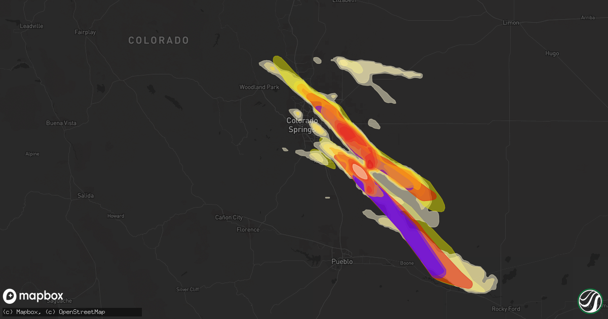
Hail Map in Colorado Springs, CO on August 5, 2023
Get this storm
August 5 map
$229
one time, instant access
Download today. No call, no setup
Keep the $229
Bought the map and want the full workflow? Apply the entire $229 to a subscription within 7 days. None of it is wasted.
Every map, not just this one
This buys you this map. Subscription and you get every map we run, in the markets you choose from a few cities to whole states to nationwide. Plus real-time alerts the moment a storm fires.
Contact data
Name, contact info, occupancy, even credit band for addresses in the footprint. You go from where it hit to who to call.
Become the source they trust
Unlimited branding weather history reports on demand. You already have the documented answer ready for the property owner, and you are the one who showed up with it.
Property data and RoofTrace estimates
Pull up any address you have got, its value and the exact code rules for that jurisdiction, straight from One Click Code. Then RoofTrace estimates the squares, pitch, and roof value, priced the way you price.
Storm reports in Colorado Springs, CO
Colorado Springs, CO
| Date | Description |
|---|---|
| 08/05/20234:49 PM CDT | Report from mping: tennis ball |
| 08/05/20234:48 PM CDT | Report from mping: baseball+ |
| 08/05/20234:47 PM CDT | Report from mping: hen egg+ |
| 08/05/20234:46 PM CDT | Measured 3.3 inch hail with picture on social media. |
| 08/05/20234:45 PM CDT | Hail between 3 and 4 inches. |
| 08/05/20234:43 PM CDT | Report from mping: quarter |
| 08/05/20234:35 PM CDT | Relayed via social media. |
| 08/05/20234:31 PM CDT | A local report indicates 1.25 inch wind near 4 E Security |
| 08/05/20234:26 PM CDT | Report from mping: tennis ball |
| 08/05/20234:23 PM CDT | Report from mping: half dollar |
| 08/05/20234:23 PM CDT | A local report indicates 1.00 inch wind near 2 ESE Security |
| 08/05/20234:14 PM CDT | Report from mping: baseball |
| 08/05/20234:08 PM CDT | Report from mping: tennis ball |
| 08/05/20234:00 PM CDT | Report from mping: ping pong ball |
| 08/05/20234:00 PM CDT | A local report indicates 1.75 inch wind near 3 N Peterson AFB |
| 08/05/20234:00 PM CDT | Report from mping: ping pong ball |
| 08/05/20233:59 PM CDT | Report from mping: golf ball |
| 08/05/20233:57 PM CDT | A local report indicates 2.00 inch wind near 4 NE Peterson AFB |
| 08/05/20233:57 PM CDT | A local report indicates 2.00 inch wind near 3 NE Peterson AFB |
| 08/05/20233:56 PM CDT | Report from mping: ping pong ball |
| 08/05/20233:53 PM CDT | Numerous reports of ping pong to golf ball size hail. |
| 08/05/20233:49 PM CDT | A local report indicates 1.75 inch wind near 4 WSW Falcon |
| 08/05/20233:46 PM CDT | Report from mping: golf ball |
| 08/05/20233:46 PM CDT | A local report indicates 1.50 inch wind near 2 SSW Falcon |
| 08/05/20233:45 PM CDT | Numerous reports of hail 1.00 to 1.5 inches in this immediate region. |
| 08/05/20233:40 PM CDT | A local report indicates 1.75 inch wind near 5 SSW Black Forest |
| 08/05/20233:38 PM CDT | A local report indicates 1.25 inch wind near 3 E Air Force Academy |
| 08/05/20233:35 PM CDT | Pictures relayed via broadcast media. |
| 08/05/20233:27 PM CDT | Report from mping: half dollar |
| 08/05/20233:15 PM CDT | Spotter reported visually seeing a funnel cloud within the past 5 minutes towards the northeast near black forest. |
| 08/05/20233:10 PM CDT | Spotter can visually see a funnel cloud to the northeast of location... Just east of monument... Near black forest. |
| 08/05/20233:03 PM CDT | Spotter can visually see a funnel cloud to the west beginning to appear... Just north of monument. |
| 08/05/20232:40 PM CDT | Spotter can visually see tornado on the ground about 3 to 4 miles north of their location. |
All States Impacted by Hail Map on August 5, 2023
All Cities Impacted by Hail Map on August 5, 2023
- Cedar Vale, KS
- Bartlesville, OK
- Barnsdall, OK
- Pawhuska, OK
- Shidler, OK
- Sedan, KS
- Ochelata, OK
- Chautauqua, KS
- Copan, OK
- Peru, KS
- S Coffeyville, OK
- Caney, KS
- Wann, OK
- Dewey, OK
- Ramona, OK
- Dearing, KS
- Niotaze, KS
- Havana, KS
- Independence, KS
- Lenapah, OK
- Delaware, OK
- Tyro, KS
- Coffeyville, KS
- Nowata, OK
- Kanorado, KS
- Burlington, CO
- Goodland, KS
- Murray, KY
- Hazel, KY
- Stratton, CO
- Bethune, CO
- Eureka Springs, AR
- Booker, TX
- Peyton, CO
- Elbert, CO
- Kiowa, CO
- Calhan, CO
- Ramah, CO
- Friona, TX
- Hereford, TX
- Summerfield, TX
- Colorado Springs, CO
- Monument, CO
- Palmer Lake, CO
- Simla, CO
- Agate, CO
- Usaf Academy, CO
- Dimmitt, TX
- Amarillo, TX
- Limon, CO
- Fountain, CO
- Rush, CO
- Yoder, CO
- Earth, TX
- Claude, TX
- Springlake, TX
- Genoa, CO
- Woodrow, CO
- Lindon, CO
- Anton, CO
- Boone, CO
- Yuma, CO
- Ordway, CO
- Sudan, TX
- Amherst, TX
- Littlefield, TX
- Eckley, CO
- Vernon, CO
- Wray, CO
- Olney Springs, CO
- Crowley, CO
- Fowler, CO
- Saint Francis, KS
- Manzanola, CO
- Rocky Ford, CO
- Sugar City, CO
- La Junta, CO
- Merrill, IA
- Akron, IA
- Le Mars, IA
- Brunsville, IA
- Marcus, IA
- Remsen, IA
- Alton, IA
- Granville, IA
- Paullina, IA
- Oyens, IA
- Kim, CO
- Pritchett, CO
- Selden, KS
- Oberlin, KS
- Jennings, KS
- Dresden, KS
- Hughes, AR
- Leachville, AR
- Alvord, TX
- Sunset, TX
- Chico, TX
- Ellsworth, ME
- Aurora, ME
- Nunn, CO
- Carr, CO
- Bryant, AR
- Benton, AR
- Alexander, AR
- Akron, CO
- Onawa, IA
- Whiting, IA
- Cotton Plant, AR
- Little Rock, AR
- Brownsville, TN
- Brinkley, AR
- Grand Junction, TN
- Cobden, IL
- Alto Pass, IL
- Grover, CO
- Loveland, CO
- Brewton, AL
- Oakland, TN
- Somerville, TN
- Milton, FL
- Crestview, FL
- Dexter, MO
- Dudley, MO
- Macy, NE
- Lonsdale, AR
- Carlisle, AR
- Williston, TN
- Lynch, NE
- Verdigre, NE
- Hot Springs National Park, AR
- Story, AR
- Panhandle, TX
- Butler, AL
- Moscow, TN
- Wing, AL
- Toxey, AL
- Attapulgus, GA
- Gainestown, AL
- Jackson, AL
- Miramar Beach, FL
- Destin, FL
- Santa Rosa Beach, FL
- Earle, AR
- Parkin, AR
- Drummonds, TN
- Cardwell, MO
- Alamo, TN
- Scott, AR
- Malvern, AR
- Lonoke, AR
- Molino, FL
- Perdido, AL
- Laurel Hill, FL
- Wynne, AR
- McDavid, FL
- Luxora, AR
- Bells, TN
- Bernie, MO
- Cape Girardeau, MO
- McClure, IL
- Niceville, FL
- Fort Collins, CO
- New Madrid, MO
- Cantonment, FL
- Blytheville, AR
- Manila, AR
- Rose Hill, MS
- West Terre Haute, IN
- Inlet Beach, FL
- Halls, TN
- Eglin Afb, FL
- Jessieville, AR
- Broken Bow, OK
- Kennett, MO
- Hornersville, MO
- Senath, MO
- Mobile, AL
- Widener, AR
- Forrest City, AR
- Hull, IA
- Boyden, IA
- Mabelvale, AR
- Dell, AR
- Osceola, AR
- Ripley, TN
- Paron, AR
- Hot Springs Village, AR
- Eads, TN
- East Prairie, MO
- Dover Foxcroft, ME
- Woodland Park, CO
- Fort Walton Beach, FL
- Munford, TN
- Wilson, AR
- Rossville, TN
- Arlington, TN
- Memphis, TN
- Atoka, TN
- Millington, TN
- Climax, GA
- Hickman, KY
- Model, CO
- Clayton, KS
- Norcatur, KS
- Norton, KS
- Campo, CO
- Springfield, CO
- Almena, KS
- Prairie View, KS
- Long Island, KS
- Phillipsburg, KS
- Boise City, OK
- Riverton, NE
- Inavale, NE
- Red Cloud, NE
- Keyes, OK
- Morland, KS
- Penokee, KS
- Hill City, KS
- Bogue, KS
- Agra, KS
- Damar, KS
- Palco, KS
- Stockton, KS
- Plainville, KS
- Winona, KS
- Oakley, KS
- Grinnell, KS
- Gove, KS
- Healy, KS
- Dighton, KS
- Utica, KS
- Beeler, KS
- Guide Rock, NE
- Trinidad, CO
- Branson, CO
- Woodston, KS
- Superior, NE
- Texhoma, OK
- Dalhart, TX
- Matheson, CO
- Hugo, CO
- Natoma, KS
- Alton, KS
- Osborne, KS
- Paradise, KS
- Waldo, KS
- Lucas, KS
- Goodwell, OK
- Stratford, TX
- Karval, CO
- Cactus, TX
- Dumas, TX
- Sunray, TX
- Rush Center, KS
- La Crosse, KS
- Nekoma, KS
- Rozel, KS
- Bison, KS
- Otis, KS
- Albert, KS
- Hoisington, KS
- Larned, KS
- Olmitz, KS
- Great Bend, KS
- Claflin, KS
- Pawnee Rock, KS
- Ellinwood, KS
- Bushton, KS
- Kit Carson, CO
- Stinnett, TX
- Raymond, KS
- Chase, KS
- Hudson, KS
- St John, KS
- Lyons, KS
- Sylvia, KS
- Alden, KS
- Inman, KS
- Windom, KS
- Sterling, KS
- Little River, KS
- Abbyville, KS
- Nickerson, KS
- Wild Horse, CO
- Burrton, KS
- Haven, KS
- Hutchinson, KS
- Halstead, KS
- Buhler, KS
- Partridge, KS
- South Hutchinson, KS
- Moundridge, KS
- Newton, KS
- Valley Center, KS
- Colwich, KS
- Mount Hope, KS
- Sedgwick, KS
- Bentley, KS
- Geneseo, KS
- Marquette, KS
- Galva, KS
- Hesston, KS
- Mcpherson, KS
- Roxbury, KS
- Lehigh, KS
- Canton, KS
- Hillsboro, KS
- Durham, KS
- Goessel, KS
- Andale, KS
- Morse, TX
- Borger, TX
- Skellytown, TX
- Pampa, TX
- Miami, TX
- Walton, KS
- North Newton, KS
- Florence, KS
- Marion, KS
- Peabody, KS
- Maize, KS
- Whitewater, KS
- Kechi, KS
- Mcconnell Afb, KS
- Derby, KS
- Benton, KS
- Elbing, KS
- Andover, KS
- Burns, KS
- Potwin, KS
- Greenwich, KS
- Wichita, KS
- Cassoday, KS
- Augusta, KS
- Cottonwood Falls, KS
- Towanda, KS
- Rose Hill, KS
- El Dorado, KS
- Cedar Point, KS
- Mulvane, KS
- Elmdale, KS
- Matfield Green, KS
- Goddard, KS
- Leon, KS
- Rosalia, KS
- Eureka, KS
- Olpe, KS
- Palisade, NE
- Shelley, ID
- Idaho Falls, ID
- Stanton, NE
- Spencer, IN
- Wallace, KS
- Bancroft, NE
- Pender, NE
- Randolph, NE
- Hamilton, AL
- Denison, IA
- Sharon Springs, KS
- Geneva, NE
- Edgar, NE
- Sutton, NE
- Beaverton, AL
- Lake View, IA
- Odebolt, IA
- Kiron, IA
- Wall Lake, IA
- Knoxville, AL
- Eutaw, AL
- Macon, MS
- Battle Creek, IA
- Correctionville, IA
- Charter Oak, IA
- Ute, IA
- Dow City, IA
- Arion, IA
- Soldier, IA
- Nunnelly, TN
- Lyles, TN
- Shuqualak, MS
- Brady, NE
- Maxwell, NE
- Preston, MS
- Otis, CO
- Maple, TX
- Morton, TX
- New Raymer, CO
- Briggsdale, CO
- Fort Morgan, CO
- Oneill, NE
- Rosalie, NE
- Jackson, TN
- Beech Bluff, TN
- Beatrice, NE
- Plymouth, NE
- De Witt, NE
- Ellis, KS
- Fulton, MS
- Walsh, CO
- Benkelman, NE
- Parks, NE
- Max, NE
- Haigler, NE
- Lenora, KS
- Kensington, KS
- Gordo, AL
- Berthoud, CO
- Freeport, FL
- Kenton, OK
- Grenville, NM
- Mankato, KS
- Esbon, KS
- Burr Oak, KS
- Mountain City, NV
- Prague, NE
- Linwood, NE
- Decatur, NE
- Henderson, TN
- Pinson, TN
- Loretto, TN
- West Point, NE
- Scribner, NE
- Neola, IA
- Missouri Valley, IA
- Modale, IA
- Persia, IA
- Blair, NE
- Herman, NE
- Logan, IA
- Odell, NE
- Hanover, KS
- Hollenberg, KS
- Bremen, KS
- Danbury, IA
- Merino, CO
- Stoneham, CO
- Craig, NE
- Hooper, NE
- Bethel Springs, TN
- Hornsby, TN
- Rogers, NE
- Glade, KS
- Jamestown, KS
- Johnstown, CO
- Jonesboro, IL
- Hackleburg, AL
- Booneville, MS
- Medicine Lodge, KS
- Wisner, NE
- Pilger, NE
- Idalia, CO
- Tamms, IL
- Thebes, IL
- Concordia, KS
- Schuyler, NE
- David City, NE
- Saulsbury, TN
- Shickley, NE
- Tremont, MS
- Ogallah, KS
- Wakeeney, KS
- Bird City, KS
- Farwell, NE
- Portales, NM
- Pep, NM
- Crab Orchard, NE
- Filley, NE
- Mullinville, KS
- Sulligent, AL
- Clay Center, NE
- Luray, TN
- Ault, CO
- Boligee, AL
- McDonald, KS
- Atwood, KS
- Poland, IN
- Huron, TN
- Pickrell, NE
- Swanton, NE
- Cortland, NE
- Wilber, NE
- Clatonia, NE
- Lebanon, TN
- Mount Juliet, TN
- Carrollton, AL
- Aliceville, AL
- Tekamah, NE
- Ullin, IL
- Scott City, MO
- Saint Joseph, TN
- Killen, AL
- Iron City, TN
- Western, NE
- Daykin, NE
- Ohiowa, NE
- Strang, NE
- Milligan, NE
- Saronville, NE
- Tobias, NE
- Walthill, NE
- Cheraw, CO
- Clyde, KS
- Clifton, KS
- Washington, KS
- Fairview, TN
- Bloomington, NE
- Stratton, NE
- Joes, CO
- Kirk, CO
- Lebanon, KS
- Smith Center, KS
- Moorhead, IA
- Elwood, IN
- Tipton, IN
- Atlanta, IN
- Bolivar, TN
- Cope, CO
- Ida Grove, IA
- Herndon, KS
- Monument, KS
- Cherokee, AL
- Iuka, MS
- Diller, NE
- Flagler, CO
- Arriba, CO
- Evergreen, AL
- Andalusia, AL
- Burchard, NE
- Detroit, AL
- Winside, NE
- Hoskins, NE
- Dunlap, IA
- Brilliant, AL
- Guin, AL
- Gilbertsville, KY
- Benton, KY
- Symsonia, KY
- Calvert City, KY
- De Kalb, MS
- Wolf Lake, IL
- Medon, TN
- Finger, TN
- Elida, NM
- Morrowville, KS
- Corinth, MS
- Glen, MS
- Burnsville, MS
- Haviland, KS
- Protection, KS
- Red Bay, AL
- Russellville, AL
- Winfield, AL
- Rogers, NM
- Oakland, NE
- Uehling, NE
- Dodge, NE
- Haddam, KS
- Linn, KS
- Adams, NE
- Spruce Pine, AL
- Phil Campbell, AL
- Hodges, AL
- Narka, KS
- Seminole, AL
- Green, KS
- Rienzi, MS
- Tishomingo, MS
- Mantachie, MS
- Bear Creek, AL
- Golden, MS
- Haleyville, AL
- Vina, AL
- Scooba, MS
- Emelle, AL
- Attica, KS
- Lincoln, ME
- Ashton, NE
- Pulaski, IL
- Louisville, MS
- Sturgis, MS
- Uriah, AL
- Hoxie, KS
- Lamar, CO
- Mercer, TN
- Columbus, NE
- Florence, AL
- Lexington, AL
- Sloan, IA
- Columbus, MS
- Falkner, MS
- Ripley, MS
- Paducah, KY
- Brookport, IL
- Ledbetter, KY
- Grand Chain, IL
- Las Animas, CO
- Republican City, NE
- Minneola, KS
- Bucklin, KS
- Howells, NE
- Clay Center, KS
- Morganville, KS
- Aurora, KS
- Dickson, TN
- Hubbell, NE
- Reynolds, NE
- Eagle Lake, ME
- Mason, TN
- Wakefield, NE
- Snyder, CO
- Severy, KS
- Piedmont, KS
- Hamilton, KS
- Madison, KS
- Emporia, KS
- Hartford, KS
- Neosho Rapids, KS
- Virgil, KS
- Fall River, KS
- Toronto, KS
- Neal, KS
- Howard, KS
- Iona, ID
- Gridley, KS
- Burlington, KS
- Yates Center, KS
- Fredonia, KS
- Neosho Falls, KS
- Waverly, KS
- Lebo, KS
- Buffalo, KS
- Le Roy, KS
- Westphalia, KS
- Humboldt, KS
- Chanute, KS
- Piqua, KS
- Iola, KS
- Benedict, KS
- Colony, KS
- Warner, OK
- Alva, OK
- Burlington, OK
- Shubert, NE
- Nemaha, NE
- Hancock, IA
- Oakland, IA
- Walnut, MS
- Powhattan, KS
- Robinson, KS
- Denton, KS
- Everest, KS
- Horton, KS
- Hiawatha, KS
- Okmulgee, OK
- Haskell, OK
- Savannah, TN
- Council Bluffs, IA
- Underwood, IA
- McClelland, IA
- Medford, OK
- Deer Creek, OK
- Nardin, OK
- Falls City, NE
- Verdon, NE
- Carmen, OK
- Aline, OK
- Ramer, TN
- Michie, TN
- Guys, TN
- Hays, KS
- Tecumseh, NE
- Steinauer, NE
- Fayette, AL
- Berry, AL
- Bankston, AL
- Alexander, KS
- Bazine, KS
- Ness City, KS
- Auburn, IA
- Vona, CO
- Seibert, CO
- Coldwater, KS
- Wilmore, KS
- Epes, AL
- Gainesville, AL
- Pocahontas, TN
- Middleton, TN
- Nashville, KS
- Zenda, KS
- Vossburg, MS
- Mounds, OK
- Beggs, OK
- Logan, KS
- Wakita, OK
- Anthony, KS
- Waldron, KS
- Bluff City, KS
- Amorita, OK
- Manchester, OK
- Agenda, KS
- Minden, IA
- Avoca, IA
- Shelby, IA
- Hickory Valley, TN
- Shiloh, TN
- Counce, TN
- Selmer, TN
- Stantonville, TN
- Adamsville, TN
- Crump, TN
- Lamont, OK
- Blackwell, OK
- Tonkawa, OK
- McCracken, KS
- Ralston, OK
- Walnut, IA
- Randolph, KS
- Milnesand, NM
- Webbers Falls, OK
- Porum, OK
- Jewell, KS
- Ashland, KS
- Hopkinsville, KY
- Herndon, KY
- Cadiz, KY
- Troy, KS
- Atchison, KS
- Bendena, KS
- Tiplersville, MS
- Carbon Hill, AL
- Steele City, NE
- Atlantic, IA
- Lewis, IA
- Cumberland, IA
- Griswold, IA
- Dacoma, OK
- Cherokee, OK
- Wiota, IA
- Fowler, KS
- Isabel, KS
- Sawyer, KS
- Manilla, IA
- Michigan City, MS
- Lake City, KS
- Plattsmouth, NE
- Palmer, KS
- Pawnee, OK
- Hardtner, KS
- Morris, OK
- Harper, KS
- Danville, KS
- Northport, AL
- Glencoe, OK
- Stigler, OK
- Beaver Dam, KY
- Eufaula, OK
- Kuttawa, KY
- Coats, KS
- Brownell, KS
- Stanton, IA
- Red Oak, IA
- Fairview, KS
- Ashland, MS
- Nash, OK
- Jet, OK
- Hendley, NE
- Beaver City, NE
- Argonia, KS
- Baileyville, KS
- Gruver, TX
- Greenwood Springs, MS
- Tompkinsville, KY
- Milan, KS
- Akron, AL
- La Grange, TN
- Mooreville, MS
- Tupelo, MS
- Quinton, OK
- Mcalester, OK
- Buffalo, OK
- Rosston, OK
- Cromwell, KY
- Morgantown, KY
- Sterling, NE
- Elk Creek, NE
- Checotah, OK
- Pulaski, TN
- Freedom, OK
- Kellerton, IA
- Davis City, IA
- Lamoni, IA
- Hackett, AR
- Fort Smith, AR
- Prospect, TN
- Corning, IA
- Prescott, IA
- Clearfield, IA
- Diagonal, IA
- Lenox, IA
- Muldrow, OK
- Keota, OK
- South Pittsburg, TN
- Garnett, KS
- Elkmont, AL
- Helena, OK
- Lancaster, KS
- Greenwood, AR
- Sharon, KS
- Saint Joseph, MO
- De Kalb, MO
- Rushville, MO
- Grand River, IA
- Spiro, OK
- Pocola, OK
- Winston, MO
- Weatherby, MO
- Kidder, MO
- Gentry, MO
- Penrose, CO
- Oktaha, OK
- Bixby, OK
- Council Hill, OK
- Boynton, OK
- Charleston, AR
- Faucett, MO
- Wathena, KS
- Milton, KS
- Lavaca, AR
- Barling, AR
- Glenpool, OK
- Petersburg, TN
- Frankewing, TN
- Fayetteville, TN
- Goodspring, TN
- Ardmore, TN


