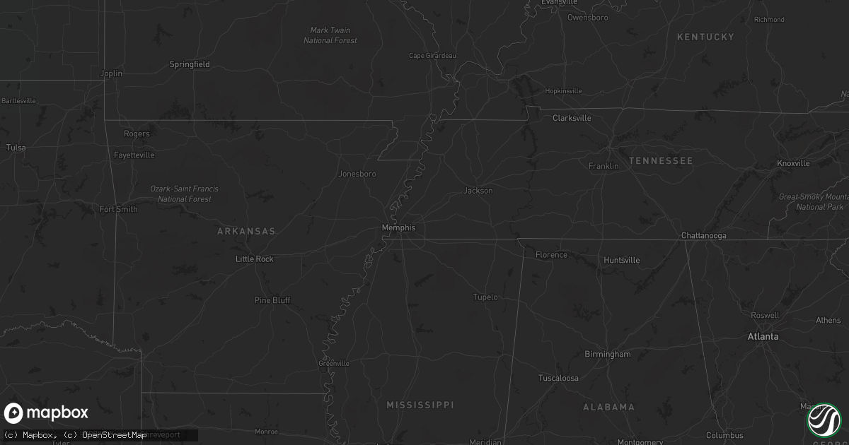
Hail Map in West Virginia on August 4, 2022
Get this storm
August 4 map
$229
one time, instant access
Download today. No call, no setup
Keep the $229
Bought the map and want the full workflow? Apply the entire $229 to a subscription within 7 days. None of it is wasted.
Every map, not just this one
This buys you this map. Subscription and you get every map we run, in the markets you choose from a few cities to whole states to nationwide. Plus real-time alerts the moment a storm fires.
Contact data
Name, contact info, occupancy, even credit band for addresses in the footprint. You go from where it hit to who to call.
Become the source they trust
Unlimited branding weather history reports on demand. You already have the documented answer ready for the property owner, and you are the one who showed up with it.
Property data and RoofTrace estimates
Pull up any address you have got, its value and the exact code rules for that jurisdiction, straight from One Click Code. Then RoofTrace estimates the squares, pitch, and roof value, priced the way you price.
Storm reports in West Virginia
West Virginia
| Date | Description |
|---|---|
| 08/04/20224:27 PM CDT | Multiple trees down across allison road. |
| 08/04/20223:46 PM CDT | Downed tree partially blocking the roadway near the 2500 block of shirley rd. |
| 08/04/20222:59 PM CDT | Multiple trees down just east of martinsburg. |
| 08/04/20222:52 PM CDT | Multiple trees down along wv-9 hedgesville road. |
| 08/04/20222:52 PM CDT | Multiple trees down along hedgesville rd. |
| 08/04/20222:38 PM CDT | Trees blew down near the intersection of ascension drive and terrain drive. |
| 08/04/20222:32 PM CDT | Tree down along bald eagle trail |
| 08/04/20222:32 PM CDT | Trees down near the intersection of ascension dr and terrain dr. |
| 08/04/20222:02 PM CDT | A tree was down along johnson mill road. |
| 08/04/20222:00 PM CDT | A tree was down along highland ridge road. |
| 08/04/202212:11 PM CDT | Three trees down in old fields near us-220. |
| 08/03/202211:24 PM CDT | At 423 PM EDT, a severe thunderstorm was located near Inwood, or 8 miles west of Charles Town, moving northeast at 10 mph. HAZARD...60 mph wind gusts and quarter size hail. SOURCE...Radar indicated. IMPACT...Damaging winds will cause some trees and large branches to fall. This could injure those outdoors, as well as damage homes and vehicles. Roadways may become blocked by downed trees. Localized power outages are possible. Unsecured light objects may become projectiles. Locations impacted include... Martinsburg, Ranson, Kearneysville, Shenandoah Junction, Middleway, Winebrenners Cross, Vanville and Martinsburg Airport. |
| 08/03/202211:07 PM CDT | At 407 PM EDT, severe thunderstorms were located along a line extending from near Wilson-Conococheague to 8 miles west of Williamsport to near Martinsburg, moving northeast at 25 mph. HAZARD...60 mph wind gusts and quarter size hail. SOURCE...Radar indicated. IMPACT...Damaging winds will cause some trees and large branches to fall. This could injure those outdoors, as well as damage homes and vehicles. Roadways may become blocked by downed trees. Localized power outages are possible. Unsecured light objects may become projectiles. Locations impacted include... Hagerstown, Martinsburg, Municipal Stadium, Wilson-Conococheague, Williamsport, Saint James, Berkeley, Halfway, Falling Waters, Hedgesville and Big Spring. |
| 08/03/202210:00 PM CDT | At 300 PM EDT, a severe thunderstorm was located near Berkeley Springs, or 8 miles south of Hancock, moving northeast at 15 mph. HAZARD...60 mph wind gusts and quarter size hail. SOURCE...Radar indicated. IMPACT...Damaging winds will cause some trees and large branches to fall. This could injure those outdoors, as well as damage homes and vehicles. Roadways may become blocked by downed trees. Localized power outages are possible. Unsecured light objects may become projectiles. Locations impacted include... Clear Spring, Pecktonville, Big Pool, Johnsons Mill, Cherry Run, Spohrs Crossroads, New Hope, Spruce Pine Hollow, Sleepy Creek and Shady Grove. |
| 08/03/20229:23 PM CDT | At 223 PM EDT, a severe thunderstorm was located 9 miles northeast of Weirton, moving east at 15 mph. HAZARD...60 mph wind gusts and quarter size hail. SOURCE...Radar indicated. IMPACT...Minor hail damage to vehicles is possible. Expect wind damage to trees and power lines, resulting in some power outages. Locations impacted include... Weirton, Imperial, Sturgeon-Noblestown, Burgettstown, Frankfort Springs, Pittsburgh International Airport, Enlow, Hanover Township, Raccoon Creek State Park, Langeloth, North Fayette Township, and Slovan. |
| 08/03/20229:05 PM CDT | At 205 PM EDT, a severe thunderstorm was located 11 miles east of Addison (Webster Springs), or 11 miles east of Webster Springs, moving east at 30 mph. HAZARD...60 mph wind gusts and penny size hail. SOURCE...Radar indicated. IMPACT...Expect damage to roofs, siding, and trees. Locations impacted include... Mingo, Monterville, Valley Head and Waneta. |
| 08/03/20228:06 PM CDT | At 106 PM EDT, a severe thunderstorm was located 9 miles north of Moorefield, moving east at 10 mph. HAZARD...60 mph wind gusts and quarter size hail. SOURCE...Radar indicated. IMPACT...Damaging winds will cause some trees and large branches to fall. This could injure those outdoors, as well as damage homes and vehicles. Roadways may become blocked by downed trees. Localized power outages are possible. Unsecured light objects may become projectiles. Locations impacted include... Williamsport, Mcneill, Old Fields and Purgitsville. |
| 08/03/20227:42 PM CDT | One tree down.time estimated from radar. |
All States Impacted by Hail Map on August 4, 2022
Cities Impacted by Hail Map on August 4, 2022
- Berkeley Springs, WV
- Campton, NH
- Holderness, NH
- Jefferson, NY
- Stamford, NY
- Melrose, NY
- Troy, NY
- Holtwood, PA
- Arlington, VT
- Wysox, PA
- Wyalusing, PA
- Mechanicville, NY
- Winner, SD
- Ravena, NY
- Slingerlands, NY
- Coeymans Hollow, NY
- Alcove, NY
- Feura Bush, NY
- Selkirk, NY
- Delmar, NY
- Bainbridge, NY
- Oxford, NY
- Greene, NY
- Schaghticoke, NY
- Stillwater, NY
- Schuylerville, NY
- Eldred, PA
- Turtlepoint, PA
- Smethport, PA
- Monongahela, PA
- Elizabeth, PA
- Sykesville, MD
- Woodbine, MD
- Gambrills, MD
- Millersville, MD
- Crownsville, MD
- Panhandle, TX
- Hart, TX
- Cohoes, NY
- Windsor, VA
- Suffolk, VA
- Mount Gilead, OH
- Cardington, OH
- New Park, PA
- Fawn Grove, PA
- Airville, PA
- Stewartstown, PA
- Pylesville, MD
- Ijamsville, MD
- Monrovia, MD
- New Market, MD
- Essex, MD
- Sparrows Point, MD
- Charlotte Court House, VA
- Cullen, VA
- Dimmitt, TX
- Petersburg, TX
- Long Valley, SD
- Mission, SD
- Martin, SD
- Kilgore, NE
- Tuthill, SD
- Cody, NE
- Saint Francis, SD
- Nenzel, NE
- Norris, SD
- Parmelee, SD
- Crookston, NE
- Valentine, NE
- Somerset, OH
- Beech Creek, PA
- Laurel Bloomery, TN
- Lake City, SC
- Kingstree, SC
- New Zion, SC
- Clio, SC
- Manchester Center, VT
- Gregory, SD
- Whiteford, MD
- Street, MD
- Patton, PA
- Martinsburg, PA
- Oil City, PA
- Bessemer, PA
- Hillsville, PA
- New Castle, PA
- Edinburg, PA
- Ashville, PA
- Loretto, PA
- Danby, VT
- Wallingford, VT
- Gifford, PA
- Lutherville Timonium, MD
- Rosedale, MD
- Parkville, MD
- Halethorpe, MD
- Baltimore, MD
- Catonsville, MD
- Cockeysville, MD
- Curtis Bay, MD
- Towson, MD
- Gwynn Oak, MD
- Brooklyn, MD
- Severn, MD
- Dundalk, MD
- Phoenix, MD
- Glen Burnie, MD
- Linthicum Heights, MD
- Nottingham, MD
- Summerhill, PA
- Portage, PA
- Cropseyville, NY
- White Post, VA
- Stephens City, VA
- Floydada, TX
- Owego, NY
- Candor, NY
- Anton, TX
- Littlefield, TX
- Needmore, PA
- Warfordsburg, PA
- Mardela Springs, MD
- Kim, CO
- Pleasantville, PA
- Turbeville, SC
- Howard, PA
- Northern Cambria, PA
- Nicktown, PA
- Silverton, TX
- Pampa, TX
- Kenbridge, VA
- Dundas, VA
- Stevensville, MD
- Easton, MD
- Claiborne, MD
- Saint Michaels, MD
- Mcdaniel, MD
- Spartanburg, SC
- Pauline, SC
- Groom, TX
- White Deer, TX
- Ballston Spa, NY
- Greenwich, NY
- Saratoga Springs, NY
- Fort Edward, NY
- Ulster, PA
- Rome, PA
- Guilford, NY
- Rockwood, PA
- Saxton, PA
- James Creek, PA
- Claremont, NH
- Charlestown, NH
- Amity, PA
- Royersford, PA
- Collegeville, PA
- Schwenksville, PA
- Carrollton, OH
- Nathalie, VA
- Burke, VA
- Fairfax Station, VA
- Wytheville, VA
- Fonda, NY
- Sprakers, NY
- Canajoharie, NY
- Palatine Bridge, NY
- Oldtown, MD
- Milan, PA
- Athens, PA
- Stanardsville, VA
- Elmira, NY
- Hedgesville, WV
- Shinglehouse, PA
- Port Allegany, PA
- Bellefonte, PA
- Julian, PA
- Huntingdon, PA
- Finleyville, PA
- Mountain Top, PA
- Freeland, PA
- White Haven, PA
- Drums, PA
- Ballston Lake, NY
- Burnt Hills, NY
- Schenectady, NY
- Punxsutawney, PA
- Milford, VA
- Hustle, VA
- Champlain, VA
- Claude, TX
- Campbell, NY
- Addison, NY
- Johnsonville, NY
- Buskirk, NY
- Valley Falls, NY
- Commodore, PA
- Cherry Tree, PA
- Wilkes Barre, PA
- Gouldsboro, PA
- Dysart, PA
- Divide, CO
- Florissant, CO
- Woodland Park, CO
- Horseheads, NY
- Wye Mills, MD
- Queen Anne, MD
- Centreville, MD
- Queenstown, MD
- Clifton Park, NY
- Tyrone, PA
- Spruce Creek, PA
- Peyton, CO
- Blairsville, PA
- Rougemont, NC
- Timberlake, NC
- Cloudcroft, NM
- Fairfax, VA
- Annandale, VA
- Falls Church, VA
- Florence, SC
- Brandywine, MD
- Mount Upton, NY
- North Bennington, VT
- Eagle Bridge, NY
- Bennington, VT
- Hoosick Falls, NY
- Tulia, TX
- Quitaque, TX
- Mill Hall, PA
- Greensboro, MD
- Ridgely, MD
- Cordova, MD
- Goldsboro, MD
- Denton, MD
- Felton, DE
- Hillsboro, MD
- Harrington, DE
- Royal Oak, MD
- Big Prairie, OH
- Glenmont, OH
- Brinkhaven, OH
- Alexandria, VA
- Monroeton, PA
- Towanda, PA
- Elida, NM
- Byron, GA
- Sussex, VA
- Yale, VA
- Stony Creek, VA
- Waverly, VA
- Donnybrook, ND
- Summit, NY
- Fultonham, NY
- Richmondville, NY
- West Fulton, NY
- Warnerville, NY
- Harleysville, PA
- Damascus, MD
- Brookeville, MD
- Gaithersburg, MD
- Mount Airy, MD
- Nichols, NY
- Waverly, NY
- Barton, NY
- Hancock, MD
- Kearneysville, WV
- Clear Brook, VA
- Bunker Hill, WV
- Berryville, VA
- Summit Point, WV
- Springfield, WV
- Cumberland, MD
- Newtown, VA
- Grasonville, MD
- Fallston, MD
- Monkton, MD
- Baldwin, MD
- Forest Hill, MD
- Jarrettsville, MD
- Lunenburg, VA
- Victoria, VA
- Bowie, MD
- Edgewater, MD
- Riva, MD
- Harwood, MD
- Annapolis, MD
- Galesville, MD
- Davidsonville, MD
- Upper Marlboro, MD
- West River, MD
- Lothian, MD
- Shady Side, MD
- New Waterford, OH
- East Palestine, OH
- Enon Valley, PA
- Petersburg, OH
- New Springfield, OH
- Pamplin, VA
- Allen, SD
- Schenevus, NY
- Worcester, NY
- Harpersfield, NY
- Charlotteville, NY
- Davenport, NY
- Hollis, OK
- Barney, GA
- Quitman, GA
- Morven, GA
- Henderson, NC
- Windsor, NY
- Alexandria, PA
- Petersburg, PA
- Pennsylvania Furnace, PA
- Port Crane, NY
- Linden, VA
- Flint Hill, VA
- Huntly, VA
- Hume, VA
- Belleville, PA
- Reedsville, PA
- Milroy, PA
- Dunkirk, MD
- Cripple Creek, CO
- White River, SD
- Wood, SD
- Okreek, SD
- Sayre, PA
- Ebensburg, PA
- Middletown, VA
- Strasburg, VA
- Odenton, MD
- Glenn Dale, MD
- Greenbelt, MD
- Lanham, MD
- Fort George G Meade, MD
- Laurel, MD
- Beltsville, MD
- Martinsburg, WV
- Olton, TX
- Plainview, TX
- Kress, TX
- Saint Johns, AZ
- Lakeland, GA
- Trappe, MD
- Canyon, TX
- Hudson, FL
- Brandon, MS
- Pelahatchie, MS
- King William, VA
- West Point, VA
- Saltsburg, PA
- Avonmore, PA
- Lakeview, TX
- Dorset, VT
- Childress, TX
- Yorktown, VA
- Happy, TX
- Wayside, TX
- Courtland, VA
- Tampa, FL
- Dublin, VA
- Voorheesville, NY
- Fort Hancock, TX
- New Port Richey, FL
- Skellytown, TX
- Trinidad, CO
- Nazareth, TX
- Chapel Hill, NC
- Hillsborough, NC
- Borger, TX
- Sierra Blanca, TX
- Shelby, NC
- Pittsboro, NC
- Easley, SC
- Bokeelia, FL
- West Rupert, VT
- Pawlet, VT
- Clover, VA
- Woodville, VA
- Washington, VA
- Sperryville, VA
- Lawrenceville, VA
- Dolphin, VA
- Webster Springs, WV
- Brownfield, TX
- Pritchett, CO
- Raleigh, NC
- Odessa, FL
- Graham, NC
- Efland, NC
- Shonto, AZ
- Randolph, VA
- Murrysville, PA
- Export, PA
- Slickville, PA
- Bryans Road, MD
- Accokeek, MD
- Effingham, SC
- Pamplico, SC
- Crewe, VA
- Turkey, TX
- Carrizozo, NM
- Woodbridge, VA
- Spring Hill, FL
- Land O'Lakes, FL
- Winburne, PA
- Lanse, PA
- Allport, PA
- Munson, PA
- Philipsburg, PA
- Hawk Run, PA
- West Decatur, PA
- Morrisdale, PA
- Gansevoort, NY
- Middleburgh, NY
- Flintstone, MD
- Ewell, MD


