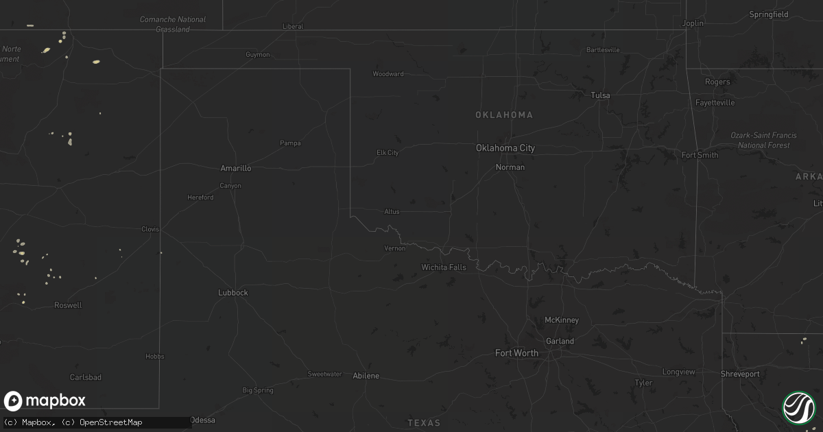
Hail Map on August 3, 2022
Get this storm
August 3 map
$229
one time, instant access
Download today. No call, no setup
Keep the $229
Bought the map and want the full workflow? Apply the entire $229 to a subscription within 7 days. None of it is wasted.
Every map, not just this one
This buys you this map. Subscription and you get every map we run, in the markets you choose from a few cities to whole states to nationwide. Plus real-time alerts the moment a storm fires.
Contact data
Name, contact info, occupancy, even credit band for addresses in the footprint. You go from where it hit to who to call.
Become the source they trust
Unlimited branding weather history reports on demand. You already have the documented answer ready for the property owner, and you are the one who showed up with it.
Property data and RoofTrace estimates
Pull up any address you have got, its value and the exact code rules for that jurisdiction, straight from One Click Code. Then RoofTrace estimates the squares, pitch, and roof value, priced the way you price.
States Impacted by Hail Map on August 3, 2022
Storm reports
Ohio
| Date | Description |
|---|---|
| 08/03/20225:55 PM CDT | A tree was downed in a yard... Taking down electrical wires going to the house. |
| 08/03/20225:40 PM CDT | Updates previous report. Trees down and a semi truck blown over. |
| 08/03/20225:37 PM CDT | Asos station ktol toledo. |
| 08/03/20225:24 PM CDT | Corrects previous tstm wnd dmg report from liberty center. Updates previous report. Trees down and a semi truck blown over. |
| 08/03/20225:15 PM CDT | Several large tree limbs down near road 11 and road s intersection. A large tree also downed and roof damage to a nearby barn. Time estimated from radar. |
| 08/03/20225:10 PM CDT | Private weather station measured gust. Shingles blew off of the roof as well. |
| 08/03/20224:40 PM CDT | Multiple trees/power poles down in the area of the city. |
| 08/03/20224:25 PM CDT | Pear tree split in half. |
| 08/03/20223:54 PM CDT | Branches down |
| 08/03/20222:52 AM CDT | At 751 PM EDT, a severe thunderstorm was located near Sabina, moving northeast at 20 mph. HAZARD...60 mph wind gusts and penny size hail. SOURCE...Radar indicated. IMPACT...Expect damage to trees and power lines. Locations impacted include... Washington Court House, Wilmington, Sabina, New Vienna, Jeffersonville, Bloomingburg, Staunton, Milledgeville, Octa, Melvin, Bloomington, New Antioch, Jasper Mills, Lees Creek and Reesville.This includes I-71 in Ohio between mile markers 69 and 70. |
| 08/02/20228:37 PM CDT | Flag pole knocked down by wind gust. Time estimated from radar. |
Arizona
| Date | Description |
|---|---|
| 08/03/20225:41 AM CDT | At 1040 PM MST, severe thunderstorms were located along a line extending from 13 miles north of Steins to 9 miles west of Cotton City, moving west at 15 mph. HAZARD...60 mph wind gusts and quarter size hail. SOURCE...Radar indicated. IMPACT...Hail damage to vehicles is expected. Expect wind damage to roofs, siding, and trees. Locations impacted include... San Simon. |
| 08/03/20223:50 AM CDT | At 849 PM MST, a severe thunderstorm was located near Tombstone, or 15 miles northeast of Sierra Vista, moving northwest at 15 mph. HAZARD...60 mph wind gusts and quarter size hail. SOURCE...Radar indicated. IMPACT...Hail damage to vehicles is expected. Expect wind damage to roofs, siding, and trees. Locations impacted include... Tombstone, Fairbank and Charleston. |
| 08/03/20223:14 AM CDT | At 814 PM MST, a severe thunderstorm was located near Bisbee, moving northwest at 10 mph. HAZARD...60 mph wind gusts and quarter size hail. SOURCE...Radar indicated. IMPACT...Hail damage to vehicles is expected. Expect wind damage to roofs, siding, and trees. Locations impacted include... Bisbee. |
| 08/03/20222:54 AM CDT | Measured at the airport. |
| 08/03/20222:33 AM CDT | At 733 PM MST, a severe thunderstorm was located 8 miles southwest of Bisbee-Douglas Airport, or 10 miles west of Douglas, moving northeast at 5 mph. HAZARD...60 mph wind gusts and quarter size hail. SOURCE...Radar indicated. IMPACT...Hail damage to vehicles is expected. Expect wind damage to roofs, siding, and trees. Locations impacted include... Bisbee, Naco, Bisbee-Douglas Airport and Pirtleville. |
| 08/03/20222:07 AM CDT | At 707 PM MST, a severe thunderstorm was located 20 miles northeast of Bisbee-Douglas Airport, or 22 miles northeast of Douglas, moving north at 15 mph. HAZARD...60 mph wind gusts and half dollar size hail. SOURCE...Radar indicated. IMPACT...Hail damage to vehicles is expected. Expect wind damage to roofs, siding, and trees. Locations impacted include... Rucker Canyon. |
| 08/03/202212:43 AM CDT | At 543 PM MST, a severe thunderstorm was located over Parker Canyon Lake, or 14 miles west of Sierra Vista, moving northwest at 10 mph. HAZARD...60 mph wind gusts and quarter size hail. SOURCE...Radar indicated. IMPACT...Hail damage to vehicles is expected. Expect wind damage to roofs, siding, and trees. Locations impacted include... Elgin, Fort Huachuca, Parker Canyon Lake and Canelo. |
| 08/02/202211:00 PM CDT | Power poles down on gleeson road. |
| 08/02/202210:28 PM CDT | At 327 PM MST, a severe thunderstorm was located over Blake Ranch Road, or 11 miles east of Kingman, moving west at 10 mph. HAZARD...60 mph wind gusts and quarter size hail. SOURCE...Radar indicated. IMPACT...Hail damage to vehicles is expected. Expect wind damage to roofs and trees. Locations impacted include... Kingman, Dw Ranch Road, Blake Ranch Road, New Kingman-Butler, Hualapai Mountain Park and Golden Valley. |
| 08/02/202210:11 PM CDT | At 311 PM MST, a severe thunderstorm was located near Jerome, or 12 miles northeast of Prescott Valley, moving southwest at 5 mph. HAZARD...60 mph wind gusts and quarter size hail. SOURCE...Radar indicated. IMPACT...Hail damage to vehicles is expected. Expect wind damage to roofs, siding, and trees. Locations impacted include... Yavapai County Fairgrounds, Jerome, Potato Patch Campground, Mingus Mountain Campground and Playground Group Campground. |
| 08/02/20229:43 PM CDT | At 243 PM MST, a severe thunderstorm was located 15 miles south of Young, or 16 miles north of Roosevelt, moving west at 25 mph. HAZARD...60 mph wind gusts and quarter size hail. SOURCE...Radar indicated. IMPACT...Hail damage to vehicles is expected. Expect wind damage to roofs, siding, and trees. Locations impacted include... Reynolds Creek Group Campground and Rose Creek Campground. |
Oregon
| Date | Description |
|---|---|
| 08/03/20222:55 AM CDT | At 754 PM MDT, a severe thunderstorm was located near Mann Creek Reservoir, or near Weiser, moving east at 20 mph. HAZARD...60 mph wind gusts and quarter size hail. SOURCE...Radar indicated. IMPACT...Hail damage to vehicles is expected. Expect wind damage to roofs, siding, and trees. Locations impacted include... Weiser, Midvale, Paddock Valley Reservoir, Mann Creek Reservoir, Bear Creek Summit, Presley Bridge, Star Butte, Midvale Hill, Crane Creek Reservoir and Annex. |
Kentucky
| Date | Description |
|---|---|
| 08/03/20224:14 PM CDT | One tree down on rabbit hash road. |
| 08/03/20224:49 AM CDT | At 949 PM EDT, severe thunderstorms were located along a line extending from near Maynardville to 7 miles northwest of Oliver Springs, moving north at 20 mph. HAZARD...60 mph wind gusts and nickel size hail. SOURCE...Radar indicated. IMPACT...Expect damage to roofs, siding, and trees. Locations impacted include... Clinton, La Follette, Oneida, Maynardville, Oliver Springs, Jacksboro, Huntsville, Helenwood, Jellico and Caryville.This includes Interstate 75 in Tennessee between mile markers 120 and161. |
| 08/03/202212:24 AM CDT | At 524 PM EDT, a severe thunderstorm was located near Union, moving northeast at 40 mph. HAZARD...60 mph wind gusts. SOURCE...Radar indicated. IMPACT...Expect damage to trees and power lines. Locations impacted include... Covington, Florence, Independence, Erlanger, Edgewood, Elsmere, Fort Mitchell, Villa Hills, Taylor Mill, Fort Wright, Crescent Springs, Crestview Hills, Park Hills, Lakeside Park, Oakbrook, Burlington, Union, Wilder, Ryland Heights and Fairview.This includes I-75 in Kentucky between mile markers 175 and 190. |
| 08/02/20228:30 PM CDT | Wrn ambassador reported multiple trees down and a porch roof blown off on old monticello road near smith chapel church. 600 power outages in clinton county also. Time e |
Iowa
| Date | Description |
|---|---|
| 08/03/202211:05 AM CDT | Several small limbs down. Winds estimated around 60 mph. |
| 08/03/202211:00 AM CDT | Some power lines reported down along with power outages. |
| 08/03/202211:00 AM CDT | Reports of tree branches down and tree damage around town. |
| 08/03/202210:59 AM CDT | Livestock building flipped over. Time is estimated based on radar. |
| 08/03/202210:35 AM CDT | 50 to 60 mph wind gusts estimated. Heavy downpour also with winds. |
| 08/03/202210:30 AM CDT | 6 inch diameter tree snapped. |
| 08/03/202210:30 AM CDT | Estimated 55 to 60 mph gust. |
| 08/03/202210:27 AM CDT | Small branches down. |
| 08/03/20226:28 AM CDT | At 1127 AM CDT, a severe thunderstorm was located over Earlville, or 10 miles east of Manchester, moving east at 20 mph. HAZARD...60 mph wind gusts. SOURCE...Radar indicated. IMPACT...Expect damage to roofs, siding, and trees. Locations impacted include... Manchester, Dyersville, Farley, Earlville, Hopkinton, Delhi, New Vienna, Worthington, Ryan, Delaware, Oneida, Delaware County Fairgrounds, New Wine Park, Baileys Ford Park, Petersburg and Turtle Creek Park. |
| 08/03/20226:02 AM CDT | At 1102 AM CDT, a severe thunderstorm was located over Manchester, moving east at 25 mph. HAZARD...60 mph wind gusts. SOURCE...Radar indicated. IMPACT...Expect damage to roofs, siding, and trees. Locations impacted include... Manchester, Dyersville, Earlville, Hopkinton, Delhi, Worthington, Ryan, Delaware, Oneida, Delaware County Fairgrounds, Manchester Airport, New Wine Park, Coffins Grove Park, Buck Creek, Baileys Ford Park and Turtle Creek Park. |
| 08/03/20225:29 AM CDT | At 1029 AM CDT, a severe thunderstorm was located near Brandon, or 11 miles southwest of Independence, moving northeast at 20 mph. HAZARD...60 mph wind gusts. SOURCE...Radar indicated. IMPACT...Expect damage to roofs, siding, and trees. This severe thunderstorm will remain over mainly rural areas of southeastern Black Hawk County.This includes Interstate 380 between mile markers 56 and 64. |
| 08/03/20225:19 AM CDT | At 1018 AM CDT, severe thunderstorms were located along a line extending from near La Porte City to Fairfax, moving northeast at 40 mph. HAZARD...60 mph wind gusts and penny size hail. SOURCE...Radar indicated. IMPACT...Expect damage to roofs, siding, and trees. Locations impacted include... Cedar Rapids, Independence, Anamosa, Vinton, Marion, Hiawatha, Robins, Jesup, Center Point, Fairfax, Atkins, Urbana, Central City, Springville, Palo, Shellsburg, Winthrop, Hazleton, Walker and Alburnett. |
| 08/03/20221:38 AM CDT | At 638 AM CDT, a severe thunderstorm was located near Aurelia, or 9 miles east of Cherokee, moving east at 45 mph. HAZARD...60 mph wind gusts and quarter size hail. SOURCE...Radar indicated. IMPACT...Hail damage to vehicles is expected. Expect wind damage to roofs, siding, and trees. This severe thunderstorm will be near... Storm Lake, Lakeside and Truesdale around 650 AM CDT. Sioux Rapids around 655 AM CDT.Other locations in the path of this severe thunderstorm includeAlbert City and Marathon. |
Illinois
| Date | Description |
|---|---|
| 08/03/20226:56 PM CDT | Tree limbs and power lines down in town. Time estimated. |
| 08/03/20226:10 PM CDT | 100yr long tin roof from outhouse ripped off. |
| 08/03/20226:10 PM CDT | 3in tree limbs down in aviston. Time reported via spotter and confirmed on radar. |
| 08/03/20226:02 PM CDT | Large tree snapped off at ground. |
| 08/03/20225:40 PM CDT | Measured - kblv awos. |
| 08/03/20225:23 PM CDT | Large tree limbs down... A few snapped trees... Tree on car. |
| 08/03/20225:19 PM CDT | Report from mping: tree limbs broken. |
| 08/03/20225:14 PM CDT | 3-4 inch diameter tree limbs down. |
| 08/03/20225:08 PM CDT | Numerous trees... Tree limbs and power lines blown down... Some of which were blocking roads in the oakdale lake drive area. |
| 08/03/20224:56 PM CDT | Report from mping: tree limbs broken. |
| 08/03/20224:55 PM CDT | Multiple power lines down throughout the city. |
| 08/03/20224:55 PM CDT | Large tree branches down. |
| 08/03/20224:53 PM CDT | Measured 66 kts at k3lf awos. |
| 08/03/20224:25 PM CDT | Corrects previous tstm wnd dmg report from elsah. Corrects previous tstm wnd dmg report from elsah. Multiple trees down in area. |
| 08/03/20224:25 PM CDT | Corrects previous tstm wnd dmg report from elsah. Multiple trees down in area. |
| 08/03/20224:05 PM CDT | Multiple trees down in area. |
| 08/03/20224:05 PM CDT | Power line down on west main st. Time estimated. |
| 08/03/20224:00 PM CDT | Tree and power line down near decatur airport. Time estimated. |
| 08/03/20223:59 PM CDT | A local report indicates 61 MPH wind near DECATUR AIRPORT |
| 08/03/20223:35 PM CDT | Tree fell on a house. |
| 08/03/20223:32 PM CDT | Multiple trees down on 4th and henry streets. |
| 08/03/20223:25 PM CDT | Semi truck blown over on i-55 near farmersville. |
| 08/03/20223:24 PM CDT | Road sign blown over near north bound lanes of i-55 about 4 miles north of farmersville. |
| 08/03/20222:17 PM CDT | Tree limbs downed on power lines and a shed. |
| 08/03/20222:14 PM CDT | Private weather station in clifton reported 65 mph gust. |
| 08/03/20222:05 PM CDT | Tree uprooted. |
| 08/03/20222:04 PM CDT | Report of light pole bent and several 3-6 inch tree limbs downed. Winds estimated 65mph. |
| 08/03/20222:00 PM CDT | Power lines reported down i-57 and court street exit |
| 08/03/20221:56 PM CDT | Tree down in yard. |
| 08/03/20221:55 PM CDT | Multiple trees reported down. |
| 08/03/20221:55 PM CDT | Multiple large trees uprooted and down on roadways. |
| 08/03/20221:54 PM CDT | 25 large trees downed across small memorial park. Time estimated from radar. |
| 08/03/20221:50 PM CDT | Tree downed on house... Roof damaged. |
| 08/03/20221:50 PM CDT | Tree reported down on power lines. |
| 08/03/20221:48 PM CDT | Trees and limbs reported down. |
| 08/03/20221:46 PM CDT | Large 6-8 inch limbs reported down in roadway with estimated 60-70mph winds. |
| 08/03/20221:45 PM CDT | Many 4-6 inch branches down across the area. Multiple roads closed or impassable. Residents also report no power in area. |
| 08/03/20221:43 PM CDT | Uprooted trees and large limbs down. |
| 08/03/20221:42 PM CDT | Large tree fell on to power lines with pole bending. |
| 08/03/20221:40 PM CDT | Tree reported down on lewis ave north of washington ave. |
| 08/03/20221:40 PM CDT | Photo relayed of small tree snapped near base at intersection of montrose and lake shore drive. Time estimated by radar. |
| 08/03/20221:40 PM CDT | Large 12 inch diameter tree uprooted. |
| 08/03/20221:38 PM CDT | Numerous 4 inch limbs down throughout town. |
| 08/03/20221:35 PM CDT | Large trees reported down along il-71... East of winding creek road. |
| 08/03/20221:33 PM CDT | Tree top snapped off and fell on parked car. |
| 08/03/20221:33 PM CDT | Couple of trees reported down in town. |
| 08/03/20221:28 PM CDT | Large tree limbs downed at corner of avers and roscoe. Time estimated by radar. |
| 08/03/20221:25 PM CDT | Reports of semi-trucks blown over on i-80 at i-355. |
| 08/03/20221:25 PM CDT | Numerous trees snapped and downed. Also reports of power lines downed due to tree damage. Hardest hit areas include subdivisions along parker road south of il-6. |
| 08/03/20221:25 PM CDT | Report of debris and large branches down off of 187th. Also heavy rainfall and power outages. |
| 08/03/20221:24 PM CDT | Report from mping: quarter |
| 08/03/20221:20 PM CDT | Tree limbs reported down in roadway. |
| 08/03/20221:20 PM CDT | Several large branches reported down in the cedar francis road area. |
| 08/03/20221:17 PM CDT | Tree limbs down on car and house. |
| 08/03/20221:15 PM CDT | Corrects previous countryside report with updated time based on radar. Numerous 4 inch limbs down throughout town. |
| 08/03/20227:55 AM CDT | Delayed report... Numerous 8-10 branches down... Some trampolines also turned over. Time estimated from radar. |
| 08/03/20222:07 AM CDT | At 707 PM CDT, a severe thunderstorm was located near Omega, or 9 miles east of Salem, moving east at 40 mph. HAZARD...60 mph wind gusts and penny size hail. SOURCE...Radar indicated. IMPACT...Expect damage to roofs, siding, and trees. This severe thunderstorm will be near... Cisne around 740 PM CDT.Other locations impacted by this severe thunderstorm includeJohnsonville. |
| 08/03/20222:00 AM CDT | At 659 PM CDT, severe thunderstorms were located along a line extending from Watson to near Iola to Salem, moving east at 35 mph. HAZARD...60 mph wind gusts and penny size hail. SOURCE...Radar indicated. IMPACT...Expect damage to roofs, siding, and trees. Severe thunderstorms will be near... Iola around 705 PM CDT. Louisville and Dieterich around 715 PM CDT.Other locations in the path of these severe thunderstorms includeFlora, Bible Grove, Wheeler, Xenia, Sailor Springs, Bogota, Ingrahamand Clay City. |
| 08/03/20221:50 AM CDT | At 650 PM CDT, a severe thunderstorm was located near Salem, moving east at 35 mph. HAZARD...60 mph wind gusts and penny size hail. SOURCE...Radar indicated. IMPACT...Expect damage to roofs, siding, and trees. This severe thunderstorm will be near... Kinmundy around 700 PM CDT. Omega around 705 PM CDT. Stephen Forbes Station around 710 PM CDT.This includes Interstate 57 in Illinois between exits 116 and 127. |
| 08/03/20221:34 AM CDT | At 634 PM CDT, severe thunderstorms were located along a line extending from near Shumway to 6 miles northwest of Kinmundy, moving east at 30 mph. HAZARD...60 mph wind gusts and penny size hail. SOURCE...Radar indicated. IMPACT...Expect damage to roofs, siding, and trees. Severe thunderstorms will be near... Shumway around 640 PM CDT. Effingham around 645 PM CDT. Watson around 650 PM CDT.Other locations in the path of these severe thunderstorms includeTeutopolis, Edgewood, Iola and Dieterich.This includes the following highways... Interstate 57 between mile markers 142 and 164. Interstate 70 between mile markers 78 and 100. |
| 08/03/20221:15 AM CDT | At 614 PM CDT, severe thunderstorms were located along a line extending from near Brownstown to Germantown, moving east at 35 mph. HAZARD...60 mph wind gusts. SOURCE...Radar indicated. IMPACT...Expect damage to roofs, siding, and trees. These severe thunderstorms will remain over areas of Clinton, southeastern Bond, northwestern Marion, central Fayette and northeastern Washington Counties, including the following locations: Bartelso...Alma...La Clede...Loogootee...St. James... Huey...Hoffman...Pittsburg...St. Paul and Avena.This includes the following highways... Interstate 70 in Illinois between exits 63 and 76. Interstate 57 in Illinois between exits 116 and 135.This also includes Carlyle Lake Recreational Area. |
| 08/03/202212:41 AM CDT | At 541 PM CDT, a severe thunderstorm was located 8 miles south of Olympian Village, moving southeast at 30 mph. HAZARD...60 mph wind gusts and penny size hail. SOURCE...Radar indicated. IMPACT...Expect damage to roofs, siding, and trees. This severe thunderstorm will be near... Bloomsdale around 600 PM CDT.Other locations in the path of this severe thunderstorm include RockyRidge, Weingarten, Coffman and St. Mary.This includes Interstate 55 in Missouri between exits 141 and 162. This also includes St. Joe State Park, St. Francois State Park, HawnState Park, Felix Valle House State Park, and Missouri Mines HistoricSite. |
| 08/03/202212:34 AM CDT | At 534 PM CDT, severe thunderstorms were located along a line extending from near Reno to near Lebanon, moving southeast at 30 mph. HAZARD...60 mph wind gusts and nickel size hail. SOURCE...Radar indicated. IMPACT...Expect damage to roofs, siding, and trees. Severe thunderstorms will be near... New Baden and Trenton around 545 PM CDT. Greenville, Aviston, Woburn and Van Burensburg around 550 PM CDT.Other locations in the path of these severe thunderstorms includeBreese, Albers, New Memphis, Germantown, Mulberry Grove, Okawvilleand Shobonier.This includes the following highways... Interstate 70 in Illinois between exits 24 and 68. Interstate 64 in Illinois between exits 19 and 41.This also includes Ramsey Lake State Park and Carlyle LakeRecreational Area. |
| 08/03/202212:16 AM CDT | At 516 PM CDT, a severe thunderstorm was located over Olympian Village, moving east at 45 mph. HAZARD...60 mph wind gusts. SOURCE...Radar indicated. IMPACT...Expect damage to roofs, siding, and trees. Locations impacted include... Bloomsdale and Ste. Genevieve.This includes Interstate 55 in Missouri between exits 150 and 178. This also includes Felix Valle House State Park and Sandy CreekCovered Bridge Historic Site. |
| 08/03/202212:05 AM CDT | At 505 PM CDT, a severe thunderstorm was located over Pontoon Beach, moving east at 25 mph. HAZARD...70 mph wind gusts and penny size hail. SOURCE...Radar indicated. IMPACT...Expect considerable tree damage. Damage is likely to mobile homes, roofs, and outbuildings. This severe thunderstorm will be near... Edwardsville and Maryville around 515 PM CDT. Troy around 520 PM CDT. Glen Carbon around 525 PM CDT.Other locations in the path of this severe thunderstorm include St.Jacob, Marine and Highland.This includes the following highways... Interstate 70 in Illinois between exits 21 and 24. Interstate 55 in Illinois between exits 23 and 30. Interstate 64 in Illinois between exits 9 and 14.This also includes Horseshoe Lake State Park. |
| 08/03/202212:03 AM CDT | At 503 PM EDT, severe thunderstorms were located along a line extending from Remington to near Hoopeston, moving east at 30 mph. HAZARD...60 mph wind gusts. SOURCE...Radar indicated. IMPACT...Expect damage to roofs, siding, and trees. Locations impacted include... Fowler, Otterbein, Oxford, Boswell, Ambia, Dunnington, Templeton, Wadena and Swanington. |
| 08/02/202211:42 PM CDT | At 442 PM CDT, a severe thunderstorm was located near East Gillespie, moving northeast at 30 mph. HAZARD...60 mph wind gusts and penny size hail. SOURCE...Radar indicated. IMPACT...Expect damage to roofs, siding, and trees. This severe thunderstorm will be near... Litchfield around 500 PM CDT.Other locations in the path of this severe thunderstorm includeHillsboro, Raymond and Witt.This includes Interstate 55 in Illinois between exits 44 and 63. This also includes Lake Lou Yaeger. |
| 08/02/202211:29 PM CDT | At 429 PM CDT, a severe thunderstorm was located over West Alton, moving east at 30 mph. HAZARD...60 mph wind gusts and nickel size hail. SOURCE...Radar indicated. IMPACT...Expect damage to roofs, siding, and trees. This severe thunderstorm will be near... Alton, Godfrey and East Alton around 440 PM CDT. Wood River, Pontoon Beach, South Roxana and Hartford around 445 PM CDT.Other locations in the path of this severe thunderstorm includeBethalto, Roxana, Rosewood Heights, Edwardsville and Dorsey.This includes Interstate 55 in Illinois near exit 23. This also includes Confluence State Park. |
| 08/02/202211:22 PM CDT | At 422 PM CDT, a severe thunderstorm was located over Jerseyville, moving east at 25 mph. HAZARD...60 mph wind gusts and quarter size hail. SOURCE...Radar indicated. IMPACT...Hail damage to vehicles is expected. Expect wind damage to roofs, siding, and trees. Locations impacted include... Kemper. |
| 08/02/202211:19 PM CDT | At 418 PM CDT, severe thunderstorms were located along a line extending from Philo to near Lovington, moving east at 40 mph. HAZARD...60 mph wind gusts and penny size hail. SOURCE...Radar indicated. IMPACT...Expect damage to roofs, siding, and trees. Severe thunderstorms will be near... Philo and Sidney around 425 PM CDT. Broadlands around 430 PM CDT. Homer and Allerton around 435 PM CDT.Other locations in the path of these severe thunderstorms includeArcola, Humboldt, Fairmount, Sidell, Catlin, Hindsboro, Rardin andOakland.This includes Interstate 57 between mile markers 198 and 229. |
| 08/02/202211:12 PM CDT | At 412 PM CDT, a severe thunderstorm was located over Shipman, moving northeast at 25 mph. HAZARD...60 mph wind gusts and quarter size hail. SOURCE...Radar indicated. IMPACT...Hail damage to vehicles is expected. Expect wind damage to roofs, siding, and trees. This severe thunderstorm will be near... Bunker Hill and Shipman around 420 PM CDT.Other locations in the path of this severe thunderstorm includeWilsonville, Sawyerville, Mount Clare, Gillespie, Benld, EastGillespie, Eagarville, Carlinville and Mount Olive.This includes Interstate 55 in Illinois near exit 44. This also includes Beaver Dam State Park. |
| 08/02/202210:49 PM CDT | At 348 PM CDT, severe thunderstorms were located along a line extending from near Monticello to near Macon, moving east at 30 mph. HAZARD...60 mph wind gusts and penny size hail. SOURCE...Radar indicated. IMPACT...Expect damage to roofs, siding, and trees. Severe thunderstorms will be near... Monticello and Bement around 355 PM CDT.Other locations in the path of these severe thunderstorms includeTolono, Pesotum, Savoy, Lovington, Philo, Hammond, Arthur and Atwood.This includes the following highways... Interstate 57 between mile markers 220 and 232. Interstate 72 between mile markers 144 and 153, and between milemarkers 156 and 168. |
| 08/02/202210:13 PM CDT | At 313 PM CDT, a severe thunderstorm was located over Girard, moving east at 25 mph. HAZARD...60 mph wind gusts and quarter size hail. SOURCE...Radar indicated. IMPACT...Hail damage to vehicles is expected. Expect wind damage to roofs, siding, and trees. This severe thunderstorm will be near... Farmersville around 325 PM CDT.Other locations in the path of this severe thunderstorm include WhiteOak.This includes Interstate 55 in Illinois between exits 60 and 63. |
| 08/02/202210:04 PM CDT | At 304 PM CDT, a severe thunderstorm was located over Josephville, moving east at 30 mph. HAZARD...60 mph wind gusts and nickel size hail. SOURCE...Radar indicated. IMPACT...Expect damage to roofs, siding, and trees. Locations impacted include... O'Fallon, St. Charles, St. Peters, Wentzville, Lake St. Louis, Dardenne Prairie, Weldon Spring, Cottleville, St. Paul, Moscow Mills, Grafton, Josephville, Chain of Rocks, Weldon Spring Heights, Harvester, Defiance, Orchard Farms, Flint Hill, Old Monroe and Brussels.This includes Interstate 70 in Missouri between exits 208 and 227. This also includes Pere Marquette State Park. |
| 08/02/20229:33 PM CDT | At 232 PM CDT, a severe thunderstorm was located near Latham, or 13 miles west of Decatur, moving east at 15 mph. HAZARD...60 mph wind gusts and quarter size hail. SOURCE...Radar indicated. IMPACT...Hail damage to vehicles is expected. Expect wind damage to roofs, siding, and trees. This severe thunderstorm will be near... Latham around 235 PM CDT. Harristown around 250 PM CDT.Other locations in the path of this severe thunderstorm includeWarrensburg and Decatur.This includes Interstate 72 between mile markers 134 and 138. |
| 08/02/20229:14 PM CDT | At 214 PM CDT, a severe thunderstorm was located near Middletown, or 12 miles south of Mason City, moving east at 20 mph. HAZARD...60 mph wind gusts and quarter size hail. SOURCE...Radar indicated. IMPACT...Hail damage to vehicles is expected. Expect wind damage to roofs, siding, and trees. This severe thunderstorm will be near... Williamsville around 230 PM CDT.Other locations in the path of this severe thunderstorm includeElkhart and Cornland.This includes Interstate 55 between mile markers 108 and 121. |
| 08/02/20229:01 PM CDT | At 200 PM CDT, a severe thunderstorm was located over McLean, or 14 miles southwest of Bloomington, moving northeast at 15 mph. HAZARD...60 mph wind gusts and penny size hail. SOURCE...Radar indicated. IMPACT...Expect damage to roofs, siding, and trees. Locations impacted include... Heyworth and Bloomington.This includes the following highways... Interstate 55 between mile markers 140 and 157. Interstate 74 between mile markers 134 and 135. |
| 08/02/20228:58 PM CDT | At 157 PM CDT, a severe thunderstorm was located near Elwood, or near Joliet, moving northeast at 30 mph. HAZARD...60 mph wind gusts. SOURCE...Radar indicated. IMPACT...Expect damage to roofs, siding, and trees. This severe thunderstorm will be near... New Lenox around 205 PM CDT.Other locations in the path of this severe thunderstorm includeOrland Park, Mokena and Frankfort. |
| 08/02/20228:52 PM CDT | At 151 PM CDT, a severe thunderstorm was located over Lincoln, moving east at 20 mph. HAZARD...60 mph wind gusts and penny size hail. SOURCE...Radar indicated. IMPACT...Expect damage to roofs, siding, and trees. Locations impacted include... Beason.This includes the following highways... Interstate 155 between mile markers 0 and 2. Interstate 55 between mile markers 124 and 136. |
| 08/02/20228:48 PM CDT | At 147 PM CDT, severe thunderstorms were located along a line extending from Oak Forest to University Park to Peotone, moving east at 25 mph. HAZARD...60 mph wind gusts and quarter size hail. SOURCE...Radar indicated. IMPACT...Hail damage to vehicles is expected. Expect wind damage to roofs, siding, and trees. Locations impacted include... Hammond, Gary, Merrillville, East Chicago, Schererville, Hobart, Crown Point, Highland, Munster, Cedar Lake, Lowell, Griffith, Dyer, St. John, Lake Station, Lakes of the Four Seasons, Whiting, Winfield, New Chicago and Lake Dalecarlia.Including the following interstates... Indiana I-80 between mile markers 1 and 15. Indiana I-90 between mile markers 3 and 20. Indiana I-65 between mile markers 242 and 261.This includes... Indiana University Northwest, Purdue UniversityNorthwest Hammond, Illiana Motor Speedway, Lake County Fairgrounds,and South Shore Rail Cats Baseball. |
| 08/02/20228:31 PM CDT | At 131 PM CDT, a severe thunderstorm was located over Yorkville, moving east at 35 mph. HAZARD...60 mph wind gusts and penny size hail. SOURCE...Radar indicated. IMPACT...Expect damage to roofs, siding, and trees. Locations impacted include... Aurora, Naperville, Bolingbrook, Wheaton, Romeoville, Plainfield, Woodridge, Oswego, Homer Glen, Yorkville, Plano, Lisle, Darien, Montgomery, Warrenville, Boulder Hill and Bristol.This includes... Aurora University, Benedictine University, andNorth Central College. |
| 08/02/20228:25 PM CDT | At 124 PM CDT, a severe thunderstorm was located over Long Grove, or over Buffalo Grove, moving east at 35 mph. HAZARD...60 mph wind gusts and penny size hail. SOURCE...Radar indicated. IMPACT...Expect damage to roofs, siding, and trees. Locations impacted include... Waukegan, Arlington Heights, Evanston, Palatine, Des Plaines, Mount Prospect, Glenview, Buffalo Grove, Wheeling, Northbrook, North Chicago, Mundelein, Highland Park, Wilmette, Vernon Hills, Libertyville, Lake Zurich, Lake Forest, Rolling Meadows and Deerfield.This includes... Great Lakes Naval Training Center, Lake ForestCollege, and Ravinia Music Festival. |
| 08/02/20228:22 PM CDT | At 122 PM CDT, multiple severe thunderstorms were located over New Lenox, moving east at 30 mph. HAZARD...70 mph wind gusts and penny size hail. SOURCE...Radar indicated. IMPACT...Expect considerable tree damage. Damage is likely to mobile homes, roofs, and outbuildings. Locations impacted include... Joliet, Orland Park, Tinley Park, Calumet City, Chicago Heights, Roseland, Lansing, Oak Forest, Harvey, Lockport, New Lenox, Homer Glen, Blue Island, Dolton, Park Forest, Homewood, Alsip, Matteson, Mokena and Frankfort.This includes... University of St. Francis, Windy City ThunderboltsBaseball, Channahon State Park, Chicagoland Speedway...Route 66Raceway, Hollywood Casino Amphitheatre, Governors State University,Joliet Junior College, Joliet Slammers Baseball, Prairie StateCollege, South Suburban College, and Will County Fairgrounds. |
| 08/02/20228:14 PM CDT | At 113 PM CDT, a severe thunderstorm was located over Indian Head Park, or over Burr Ridge, moving east at 30 mph. HAZARD...60 mph wind gusts and penny size hail. SOURCE...Radar indicated. IMPACT...Expect damage to roofs, siding, and trees. Locations impacted include... Chicago, Cicero, Oak Lawn, Berwyn, Downers Grove, Chicago Lawn, Englewood, Bridgeport, Chicago Loop, South Lawndale, South Shore, Midway Airport, West Town, Roseland, Austin, Burbank, Brookfield, Palos Hills, Hinsdale and Lemont.This includes... Brookfield Zoo, SeatGeek Stadium, University ofChicago, Hawthorne Park, Soldier Field, University of IllinoisChicago, Guaranteed Rate Field...IL Institute of Technology, TheLoop, Museum of Science and Industry, Museum Campus, and NortherlyIsland. |
| 08/02/20227:23 PM CDT | Tree knocked down a couple poles west of louisville on kinmundy rd. Time estimated. |
Wisconsin
| Date | Description |
|---|---|
| 08/03/202210:17 AM CDT | Delayed public report via broadcast media. Multiple trees uprooted and blown over around the cheeseville area. Time estimated based on radar. |
| 08/03/20228:02 AM CDT | Report from mping: trees uprooted or snapped; roof blown off. |
| 08/03/20227:59 AM CDT | Numerous trees down. Power poles snapped. Time estimated via radar. |
| 08/03/20227:59 AM CDT | Numerous trees down. Power poles snapped. Time estimated via radar |
| 08/03/20227:55 AM CDT | Trees down and power pole snapped. |
| 08/03/20227:50 AM CDT | Multiple trees down. Time estimated via radar. |
| 08/03/20227:50 AM CDT | Multiple trees down. Time estimated via radar |
| 08/03/20227:46 AM CDT | Numerous trees down. Power lines damaged. Time estimated via radar |
| 08/03/20227:46 AM CDT | Numerous trees down. Power lines damaged. Time estimated via radar. |
| 08/03/20227:34 AM CDT | A local report indicates 79 MPH wind near 3 W FOREST JUNCTION |
| 08/03/20227:34 AM CDT | 10-12 inch diameter tree limb damage at mulberry farms. Time estimated via radar. |
| 08/03/20227:31 AM CDT | Near highway 10 and highway 55. 3 semi trucks tipped over. A roof was blown off a barn. Several trees and power lines damaged. |
| 08/03/20227:30 AM CDT | Large pine tree snapped in half. Damage to machine shed doors. Time estimated. Measured on home weather station. |
| 08/03/20227:29 AM CDT | At 1229 AM CDT, severe thunderstorms were located along a line extending from near Columbia Heights to St. Paul Park to 5 miles southeast of Rosemount, moving east at 60 mph. HAZARD...60 mph wind gusts. SOURCE...Radar indicated. IMPACT...Expect damage to roofs, siding, and trees. Severe thunderstorms will be near... Cottage Grove and Hastings around 1235 AM CDT. Oakdale and Prescott around 1240 AM CDT. Woodbury and Mahtomedi around 1245 AM CDT.Other locations in the path of these severe thunderstorms includeRiver Falls, Stillwater, Lake Elmo, Bayport, Afton, Hudson, NorthHudson, Ellsworth, Bay City, Somerset and Roberts. |
| 08/03/20227:21 AM CDT | At 1221 PM CDT, severe thunderstorms were located along a line extending from near Poynette to near Deforest to Madison, moving east at 35 mph. HAZARD...60 mph wind gusts. SOURCE...Radar indicated. IMPACT...Expect damage to roofs, siding, and trees. Locations impacted include... Eastern Madison, Sun Prairie, Windsor, Columbus, Marshall, Waterloo, Deforest, Poynette, Fall River, Milford, Arlington, Reeseville, Otsego, Richwood, Clyman, Lowell, Doylestown, Morrisonville, Hubbleton and South Beaver Dam. |
| 08/03/20227:00 AM CDT | At 1200 AM CDT, a severe thunderstorm was located 13 miles northeast of Weston, or 13 miles southwest of Antigo, moving southeast at 45 mph. HAZARD...60 mph wind gusts and penny size hail. SOURCE...Radar indicated. IMPACT...Expect damage to roofs, siding, and trees. Locations impacted include... Wausau, Antigo, Weston, Rib Mountain, Wittenberg, Neopit, Schofield, Ringle, Norrie and Birnamwood. |
| 08/03/20226:48 AM CDT | At 1148 AM CDT, a severe thunderstorm was located near Black Earth, or near Sauk City, moving east at 45 mph. HAZARD...60 mph wind gusts. SOURCE...Radar indicated. IMPACT...Expect damage to roofs, siding, and trees. Locations impacted include... Madison, Sun Prairie, Middleton, Waunakee, McFarland, Monona, Windsor, Prairie Du Sac, Sauk City, Lake Wisconsin, Deforest, Cottage Grove, Cross Plains, Lodi, Mazomanie, Shorewood Hills, Black Earth, Maple Bluff, Dane and Arlington.People attending The Crossfit Games in Madison should seek safeshelter immediately!This includes the following Location Wisconsin State Capitol. |
| 08/03/20225:12 AM CDT | At 1012 AM CDT, a severe thunderstorm was located over Newburg, or near West Bend, moving east at 35 mph. HAZARD...60 mph wind gusts and quarter size hail. SOURCE...Radar indicated. IMPACT...Hail damage to vehicles is expected. Expect wind damage to roofs, siding, and trees. Locations impacted include... West Bend, Port Washington, Saukville, Kewaskum, Belgium, Fredonia, Newburg, Harrington Beach St Park, Boltonville, Waubeka and Fillmore. |
| 08/03/20222:23 AM CDT | At 723 AM CDT, a severe thunderstorm was located over High Cliff State Park, or 9 miles southeast of Appleton, moving east at 55 mph. HAZARD...60 mph wind gusts and quarter size hail. SOURCE...Radar indicated. IMPACT...Hail damage to vehicles is expected. Expect wind damage to roofs, siding, and trees. This severe thunderstorm will be near... Brillion around 735 AM CDT.Other locations in the path of this severe thunderstorm includeDenmark and Two Creeks. |
| 08/02/202210:46 PM CDT | At 346 AM CDT, a severe thunderstorm was located 7 miles south of Turtle Flambeau Flowage, moving east at 60 mph. HAZARD...60 mph wind gusts. SOURCE...Radar indicated. IMPACT...Expect damage to roofs, siding, and trees. Locations impacted include... Park Falls, Turtle Flambeau Flowage, Fifield, Butternut, Glidden, Butternut Lake, Pike Lake, and Musser Lake. |
| 08/02/202210:25 PM CDT | At 325 AM CDT, a severe thunderstorm was located 10 miles west of Butternut, or 12 miles west of Park Falls, moving east at 55 mph. HAZARD...60 mph wind gusts. SOURCE...Radar indicated. IMPACT...Expect damage to roofs, siding, and trees. Locations impacted include... Park Falls, Turtle Flambeau Flowage, Phillips, Fifield, Butternut, Winter, Glidden, Connors Lake, Pike Lake, Wilson Lake Near Phillips, Loretta, Butternut Lake, Cranberry Lake, Blaisdell Lake, Musser Lake, and Brantwood. |
| 08/02/20229:50 PM CDT | At 249 AM CDT, a severe thunderstorm was located over Round Lake, or 7 miles east of Hayward, moving east at 50 mph. HAZARD...60 mph wind gusts. SOURCE...Radar indicated. IMPACT...Expect damage to roofs, siding, and trees. Locations impacted include... Park Falls, Hayward, Chippewa Flowage West, Chippewa Flowage East, Round Lake, Cable, Mellen, Butternut, New Post, Chief Lake on Chippewa Flowage, Little Round Lake, Seeley, Glidden, Clam Lake, Namekagon Lake, Namekagon, Morse, Spider Lake, Northwoods Beach, and Ghost Lake. |
| 08/02/20229:15 PM CDT | At 214 AM CDT, severe thunderstorms were located along a line extending from 8 miles west of Sheldon, to near Cadott, to 7 miles northeast of Augusta, moving east at 55 mph. HAZARD...60 mph wind gusts. SOURCE...Radar indicated. IMPACT...Expect damage to roofs, siding, and trees. Severe thunderstorms will be near... Ogema around 300 AM CDT. Prentice around 305 AM CDT. Spirit around 310 AM CDT.Other locations impacted by these severe thunderstorms includeBrantwood, Clifford and Kennan. |
| 08/02/20229:03 PM CDT | At 201 AM CDT, severe thunderstorms were located along a line extending from near Cornell to near Fall Creek, moving east at 60 mph. HAZARD...60 mph wind gusts. SOURCE...Radar indicated. IMPACT...Expect damage to roofs, siding, and trees. Severe thunderstorms will be near... Thorp and Jump River around 220 AM CDT. Owen around 235 AM CDT. Abbotsford, Colby, Dorchester and Westboro around 245 AM CDT.Other locations impacted by these severe thunderstorms include Polley, Atwood, Tioga, Perkinstown, Esadore Lake and Eidsvold. |
| 08/02/20228:39 PM CDT | At 138 AM CDT, a severe thunderstorm was located over Elk Mound, or 9 miles west of Eau Claire, moving east at 50 mph. HAZARD...60 mph wind gusts. SOURCE...Radar indicated. IMPACT...Expect damage to roofs, siding, and trees. This severe thunderstorm will be near... Lake Hallie around 145 AM CDT. Chippewa Falls and Altoona around 150 AM CDT. Eau Claire and Lake Wissota around 155 AM CDT. Cadott around 210 AM CDT. Boyd around 215 AM CDT. Stanley around 220 AM CDT.Other locations impacted by this severe thunderstorm includeCaryville, Holcombe, Tilden, Otter Lake, Jim Falls, Allen, SandCreek, Chippewa Moraine State Rec Area, Brackett and Lake Eau ClaireCounty Park. |
| 08/02/20228:05 PM CDT | At 104 AM CDT, a severe thunderstorm was located near Elmwood, or 17 miles west of Menomonie, moving east at 60 mph. HAZARD...60 mph wind gusts. SOURCE...Radar indicated. IMPACT...Expect damage to roofs, siding, and trees. This severe thunderstorm will be near... Menomonie around 120 AM CDT.Other locations in the path of this severe thunderstorm include ElkMound. |
Florida
| Date | Description |
|---|---|
| 08/03/20226:25 PM CDT | Delayed report. Powerlines down and other reports of trees down in the area. |
| 08/03/20226:20 PM CDT | Delayed report. Four trees down blocking roadway on old bellamy. |
| 08/03/20225:36 PM CDT | Strong winds caused damage to a residence. Extent of damage unknown. |
| 08/03/20224:38 PM CDT | Member of public reported quarter-sized hail |
| 08/03/20222:13 AM CDT | At 713 PM EDT, a severe thunderstorm was located over Muse, or 7 miles northwest of Labelle, moving northwest at 15 mph. HAZARD...60 mph wind gusts and quarter size hail. SOURCE...Radar indicated. IMPACT...Hail damage to vehicles is expected. Expect wind damage to roofs, siding, and trees. This severe thunderstorm will remain over mainly rural areas of southeastern Charlotte and northeastern Lee Counties. |
| 08/03/20222:02 AM CDT | At 702 PM EDT, a severe thunderstorm was located over Fort Myers, moving northwest at 25 mph. HAZARD...60 mph wind gusts and quarter size hail. SOURCE...Radar indicated. IMPACT...Hail damage to vehicles is expected. Expect wind damage to roofs, siding, and trees. Locations impacted include... Cape Coral, Fort Myers, Page Park, East Dunbar, Fort Myers Villas, Matlacha, Tice, Palmona Park, Southwest Florida Airport and Harlem Heights. |
| 08/03/202212:30 AM CDT | At 530 PM EDT, a severe thunderstorm was located over Vineyards, or near Naples, moving northwest at 15 mph. HAZARD...60 mph wind gusts and quarter size hail. SOURCE...Radar indicated. IMPACT...Hail damage to vehicles is expected. Expect wind damage to roofs, siding, and trees. Locations impacted include... Naples, Golden Gate Estates, Naples Park, Vineyards and North Naples. |
Kansas
| Date | Description |
|---|---|
| 08/03/20225:46 PM CDT | Severe thunderstorm wind gusts downed tree limbs. Observer estimated 65 mph wind gusts. |
| 08/03/20225:30 PM CDT | Severe thunderstorm winds downed two trees across roads in the city of fort scott. |
| 08/03/20228:10 AM CDT | One power pole and multiple trees down across the east half of lawrence. Time estimated by radar. |
| 08/03/20227:45 AM CDT | 15 inch diameter tree snapped half way up and corn blown over in the field. |
| 08/03/20221:29 AM CDT | Delayed report - large tree downed on n1 road. Multiple smaller limbs down as well. Winds were estimated at 70 mph. Time estimated radar. |
| 08/03/202212:41 AM CDT | At 541 PM CDT, a severe thunderstorm was located 7 miles northeast of Fort Scott, moving east at 30 mph. HAZARD...60 mph wind gusts and quarter size hail. SOURCE...Radar indicated. IMPACT...Hail damage to vehicles is expected. Expect wind damage to roofs, siding, and trees. Locations impacted include... Nevada... Fort Scott... Walker... Schell City... Richards... Deerfield... Metz... Harwood... Stotesbury... Hammond... Horton... This includes Interstate 49 between mile markers 85 and 107. |
| 08/02/202211:57 PM CDT | At 456 PM CDT, a severe thunderstorm was located near Redfield, or near Fort Scott, moving east at 20 mph. Other thunderstorms near Mapleton and Uniontown could also produce severe weather within the next hour. HAZARD...60 mph wind gusts and quarter size hail. SOURCE...Radar indicated. IMPACT...Hail damage to vehicles is expected. Expect wind damage to roofs, siding, and trees. Locations impacted include... Fort Scott... Marmaton... Uniontown... Fulton... Redfield... Mapleton... Hammond... Devon... Garland... Harding... Xenia... |
Missouri
| Date | Description |
|---|---|
| 08/03/20226:45 PM CDT | Severe thunderstorm wind gusts downed a tree across the road. |
| 08/03/20225:35 PM CDT | Tree blown over onto hwy v just northwest of town. Via twitter with picture. |
| 08/03/20225:20 PM CDT | Corrects previous tstm wnd dmg report from de soto. Large tree branches blown down around town. Via facebook post with picture. |
| 08/03/20225:15 PM CDT | Large tree branches blown down around town. Via facebook post with picture. |
| 08/03/20223:43 PM CDT | Report from mping: quarter |
| 08/03/20223:42 PM CDT | Report from mping: tree limbs broken. |
| 08/03/20223:36 PM CDT | Report from mping: tree limbs broken; shingles blown off. |
| 08/03/20223:30 PM CDT | Corrects previous tstm wnd dmg report from saint ann. Large tree uprooted in town. |
| 08/03/20223:13 PM CDT | Several trees blown down onto hwy 94. |
| 08/03/20223:13 PM CDT | Falling timber reported. |
| 08/03/20223:11 PM CDT | Large tree uprooted in town. |
| 08/03/20223:05 PM CDT | Delayed report. Several pictures of large limbs down in the rolla area. Pictures via social media. |
| 08/03/20222:40 PM CDT | Thunderstorm wind gusts snapped a couple of large limbs. |
| 08/03/20228:30 AM CDT | Wind gust displaced and severely damaged a car port. Very little to no rain occurred at time of gust which may have been a microburst. Delayed report and time estimated |
| 08/03/20225:20 AM CDT | At 1020 PM CDT, a severe thunderstorm was located over Kirkwood, moving east at 20 mph. HAZARD...60 mph wind gusts. SOURCE...Radar indicated. IMPACT...Expect damage to roofs, siding, and trees. This severe thunderstorm will be near... Crestwood, Ladue, Olivette, Glendale and Oakland around 1025 PM CDT. University City, Webster Groves, Clayton, Richmond Heights, Brentwood, Rock Hill, Grantwood Village, Concord and Sappington around 1030 PM CDT. Maplewood, Shrewsbury, Lakeshire, Affton, Pagedale, Green Park, Marlborough and Mackenzie around 1035 PM CDT. Lemay, Mehlville, Oakville, St. George, Bella Villa and Wilbur Park around 1040 PM CDT.Other locations in the path of this severe thunderstorm include EastCarondelet, Columbia, Dupo, Brooklyn, East St. Louis, Cahokia,Centreville, Washington Park, Cahokia Parks Airport, Fairmont Cityand Alorton.This includes Interstate 44 in Missouri between exits 272 and 277. This also includes Scott Joplin Historic Site. |
| 08/03/20223:19 AM CDT | At 819 PM CDT, a severe thunderstorm was located over Conway, or 12 miles southwest of Lebanon, moving southeast at 30 mph. HAZARD...60 mph wind gusts and quarter size hail. SOURCE...Radar indicated. IMPACT...Hail damage to vehicles is expected. Expect wind damage to roofs, siding, and trees. Locations impacted include... Morgan... Conway... Duncan... Phillipsburg... Twin Bridges... Rader... Grovespring... Odin... This includes Interstate 44 between mile markers 108 and 109, andbetween mile markers 112 and 123. |
| 08/03/20221:56 AM CDT | At 656 PM CDT, a severe thunderstorm was located 7 miles northwest of Lebanon, moving southeast at 30 mph. HAZARD...60 mph wind gusts and quarter size hail. SOURCE...Radar indicated. IMPACT...Hail damage to vehicles is expected. Expect wind damage to roofs, siding, and trees. Locations impacted include... Lebanon... Bennett Spring State Park... Twin Bridges... Competition... Lynchburg... Dry Knob... Falcon... This includes Interstate 44 between mile markers 121 and 134. |
| 08/03/20221:55 AM CDT | Delayed report. Overnight storm produced extensive wind damage with five homes damaged... Barn destroyed... 20-30 power lines down. Numerous trees/tree limbs. Time esti |
| 08/03/20221:49 AM CDT | At 649 PM CDT, a severe thunderstorm was located over St. Robert, or over Waynesville, moving east at 35 mph. HAZARD...60 mph wind gusts and quarter size hail. SOURCE...Radar indicated. IMPACT...Hail damage to vehicles is expected. Expect wind damage to roofs, siding, and trees. Locations impacted include... Fort Leonard Wood... Waynesville... St. Robert... Edgar Springs... Laquey... Beulah... Devil's Elbow... This includes Interstate 44 between mile markers 150 and 165. |
| 08/03/20221:41 AM CDT | At 641 PM CDT, a severe thunderstorm was located near Fordland, or 8 miles south of Marshfield, moving east at 15 mph. HAZARD...60 mph wind gusts and quarter size hail. SOURCE...Radar indicated. IMPACT...Hail damage to vehicles is expected. Expect wind damage to roofs, siding, and trees. Locations impacted include... Seymour... Fordland... Diggins... Northview... This includes Interstate 44 near mile marker 96. |
| 08/02/202211:49 PM CDT | At 449 PM CDT, a severe thunderstorm was located 7 miles southeast of Miramiguoa Park, moving east at 20 mph. HAZARD...60 mph wind gusts and nickel size hail. SOURCE...Radar indicated. IMPACT...Expect damage to roofs, siding, and trees. Locations impacted include... Richwoods.This also includes Washington State Park. |
| 08/02/202210:49 PM CDT | At 349 PM CDT, a severe thunderstorm was located 9 miles northwest of Linn, moving east at 25 mph. HAZARD...60 mph wind gusts and quarter size hail. SOURCE...Radar indicated. IMPACT...Hail damage to vehicles is expected. Expect wind damage to roofs, siding, and trees. This severe thunderstorm will be near... Linn around 405 PM CDT.Other locations in the path of this severe thunderstorm includeChamois. |
| 08/02/202210:45 PM CDT | At 344 PM CDT, a severe thunderstorm was located near Hardin, moving east at 20 mph. HAZARD...60 mph wind gusts and quarter size hail. SOURCE...Radar indicated. IMPACT...Hail damage to vehicles is expected. Expect wind damage to roofs, siding, and trees. Locations impacted include... Carrollton, Jerseyville and Old Kane. |
| 08/02/202210:36 PM CDT | At 336 PM CDT, a severe thunderstorm was located near Union, moving east at 30 mph. HAZARD...60 mph wind gusts and quarter size hail. SOURCE...Radar indicated. IMPACT...Hail damage to vehicles is expected. Expect wind damage to roofs, siding, and trees. This severe thunderstorm will be near... Union, St. Clair and Parkway around 345 PM CDT.Other locations in the path of this severe thunderstorm include VillaRidge, Gray Summit and Pacific.This includes Interstate 44 in Missouri between exits 230 and 257. This also includes Robertsville State Park. |
| 08/02/202210:30 PM CDT | Tree... Tree limbs down. Unknown diameter. |
| 08/02/202210:21 PM CDT | At 320 PM CDT, a severe thunderstorm was located over Lambert-St. Louis International Airport, moving east at 10 mph. HAZARD...60 mph wind gusts and penny size hail. SOURCE...Radar indicated. IMPACT...Expect damage to roofs, siding, and trees. This severe thunderstorm will be near... University City, Clayton, St. John, Vinita Park, Charlack, Sycamore Hills and Vinita Terrace around 325 PM CDT. Florissant, Pagedale and Hanley Hills around 330 PM CDT. Berkeley, Bel-Ridge, Kinloch, Wellston, Bel-Nor, Greendale and Bellerive around 335 PM CDT. Normandy, Hillsdale, Cool Valley, Velda City, Calverton Park, Velda Village Hills, Norwood Court, Pasadena Hills, Beverly Hills and Pasadena Park around 340 PM CDT.Other locations in the path of this severe thunderstorm includeFerguson, Northwoods, Pine Lawn, Country Club Hills, Jennings,Dellwood, Flordell Hills, Moline Acres, Castle Point, St. Louis,Granite City, Bellefontaine Neighbors, Black Jack, Madison,Riverview, Venice, Spanish Lake and Glasgow Village.This includes Interstate 70 in Missouri between exits 229 and 231. This also includes Confluence State Park, First Missouri StateCapitol Historic Site, and Horseshoe Lake State Park. |
| 08/02/202210:12 PM CDT | At 312 PM CDT, a severe thunderstorm was located near Treloar, moving east at 30 mph. HAZARD...60 mph wind gusts and nickel size hail. SOURCE...Radar indicated. IMPACT...Expect damage to roofs, siding, and trees. Locations impacted include... Wentzville, Washington, Warrenton, Wright City, New Haven, Marthasville, Truesdale, Innsbrook, New Melle, Treloar, Dutzow, Foristell, Lyon and Holstein.This includes Interstate 70 in Missouri between exits 199 and 203. |
| 08/02/20229:27 PM CDT | At 226 PM CDT, a severe thunderstorm was located near Truesdale, moving east at 20 mph. HAZARD...60 mph wind gusts and penny size hail. SOURCE...Radar indicated. IMPACT...Expect damage to roofs, siding, and trees. Locations impacted include... Wentzville, Warrenton, Wright City, Truesdale, Innsbrook, New Melle, Treloar, Foristell and Holstein.This includes Interstate 70 in Missouri between exits 193 and 203. |
| 08/02/20227:31 PM CDT | Reported by trained spotter. |
| 08/02/20227:07 PM CDT | Severe thunderstorm wind gusts caused significant damage to a barn and the roof of a home suffered moderate damage. |
| 08/02/20227:07 PM CDT | Corrects previous tstm wnd dmg report from 3 wnw lebanon. Severe thunderstorm wind gusts caused significant damage to a barn and the roof of a home suffered moderate da |
North Carolina
| Date | Description |
|---|---|
| 08/03/20226:33 PM CDT | At least ten reports of trees down across the northern parts of the county. Time/location estimated from radar. |
| 08/03/20226:08 PM CDT | Multiple trees down in the northern part of the county. Time/location estimated from radar. |
| 08/03/20224:49 PM CDT | Trees blown down onto powerlines resulted in a a large power outage. |
| 08/03/20224:46 PM CDT | A local report indicates 64 MPH wind near 5 ENE EAST LAURINBURG |
| 08/03/20224:43 PM CDT | Tree reported down across nc-130 near the queheel fire department. Time estimated by radar. |
| 08/03/20224:36 PM CDT | Multiple trees down and power outages just west of maxton. Time estimated by radar. |
| 08/03/20223:16 AM CDT | At 815 PM EDT, a severe thunderstorm was located 13 miles northwest of Rutherfordton, or near Lake Lure, moving north at 10 mph. HAZARD...60 mph wind gusts and penny size hail. SOURCE...Radar indicated. IMPACT...Expect damage to trees and power lines. Locations impacted include... Black Mountain, Swannanoa, Lake Lure, Old Fort, Chimney Rock Village, Chimney Rock State Park, Shingle Hollow, Green Hill, Montreat and Bat Cave. |
| 08/03/20222:18 AM CDT | At 718 PM EDT, a severe thunderstorm was located 8 miles northeast of Forest City, or 5 miles west of Polkville, moving northwest at 10 mph. HAZARD...60 mph wind gusts and penny size hail. SOURCE...Radar indicated. IMPACT...Expect damage to trees and power lines. Locations impacted include... Forest City, Rutherfordton, Spindale, Polkville, Ellenboro, Bostic, Thermal City, Sunshine, Union Mills and Shingle Hollow. |
| 08/03/20222:01 AM CDT | At 701 PM EDT, a severe thunderstorm was located 5 miles north of Robbinsville, or near Fontana Village, moving northwest at 10 mph. HAZARD...60 mph wind gusts and penny size hail. SOURCE...Radar indicated. IMPACT...Expect damage to trees and power lines. Locations impacted include... Robbinsville, Town Of Santeetlah, Fontana Lake, Fontana Village, Lake Santeetlah, Smoky Mountains-Twentymile Creek, Stecoah, Tapoco, Cheoah and Deals Gap. |
| 08/03/202212:33 AM CDT | At 532 PM EDT, a severe thunderstorm was located over Maxton, or 7 miles east of Laurinburg, moving north at 10 mph. HAZARD...60 mph wind gusts and quarter size hail. SOURCE...Radar indicated. IMPACT...Hail damage to vehicles is expected. Expect wind damage to roofs, siding, and trees. Locations impacted include... Laurinburg, Maxton, Wagram, East Laurinburg and Bowmore. |
| 08/03/202212:33 AM CDT | At 532 PM EDT, a severe thunderstorm was located over Maxton, or near Laurinburg, and is nearly stationary. HAZARD...60 mph wind gusts and quarter size hail. SOURCE...Radar indicated. IMPACT...Minor hail damage to vehicles is possible. Expect wind damage to trees and power lines. Locations impacted include... Red Springs, Maxton, Wakulla and Prospect. |
| 08/02/20227:15 PM CDT | A few trees and large limbs down in fletcher community park. Pea to marble hail was also reported. |
| 08/02/20227:00 PM CDT | Fire dept respond to multiple trees down in the marion area. Time estimated from radar. |
South Carolina
| Date | Description |
|---|---|
| 08/03/20225:36 PM CDT | Fire chief reported numerous trees down on old clemson hwy and lawrence bridge rd. Time estimated from radar. |
| 08/03/20224:55 PM CDT | Report of trees down in iva... Sc via social media. |
| 08/03/20224:50 PM CDT | Numerous trees down in the antreville area. Time estimated from radar. |
| 08/03/20224:47 PM CDT | Dot reported a tree down at peak street and columbia avenue. Time estimated by radar. |
| 08/03/20224:40 PM CDT | Several reports from local emergency manager and public of trees and powerlines down in downtown aiken. Tree reported down in front of aiken library with another down a |
| 08/03/20224:15 PM CDT | Multiple reports of trees down east of the city of abbeville. Time estimated from radar. |
| 08/03/20224:10 PM CDT | Schp and emergency management reported trees down on neeses hwy near calvary church rd. Time estimated. |
| 08/03/20224:10 PM CDT | Schp reported trees down at middle willow rd and norway rd. Time estimated. |
| 08/03/20224:05 PM CDT | Tree down on s willow rd. Time estimated. |
| 08/03/20223:55 PM CDT | Schp reported tree in roadway at beason rd and neeses hwy. Time estimated. |
| 08/03/20223:48 PM CDT | Schp reported tree in roadway at carver school rd and dry swamp rd. Time estimated. |
| 08/03/20223:45 PM CDT | Schp reported tree in roadway on sc hwy 4 and shillings bridge rd. Time estimated. |
| 08/03/20223:35 PM CDT | Tree down at fox paw ct. Time estimated. |
| 08/03/20223:20 PM CDT | Schp reported tree in roadway on bedford ave in north. Time estimated. |
| 08/03/20223:17 PM CDT | Multiple trees down along gregg avenue in florence. Time estimated by radar. |
| 08/03/20223:16 PM CDT | Tree down at 1st texas street and alonzo road. |
| 08/03/20223:13 PM CDT | Tree down at second texas street and alonzo road. |
| 08/03/20223:00 PM CDT | Tree down near campbell thicket road and south railroad avenue due to thunderstorm outflow. |
| 08/03/20223:00 PM CDT | Tree down near campbell thicket road and south railroad avenue. |
| 08/03/20222:59 PM CDT | Tree down at 4450 hwy 78. |
| 08/03/20222:45 PM CDT | Multiple large tree branches down near the match factors trucking company off of tv road. One of the branches slammed through dry wall of a house. Wind speed is unknown |
| 08/03/20222:43 PM CDT | Tree down at 586 short cut road. |
| 08/03/20222:33 PM CDT | The berkeley county warning point reported a tree down along the 4000 block of highway 78 due to thunderstorm outflow. |
| 08/03/20221:45 PM CDT | Sumter 911 reported trees and power lines down at nettles rd and bethel church rd. Time estimated. |
| 08/03/20221:40 PM CDT | Sumter 911 reported trees and power lines down at horatio hagood rd and sc hwy 261 near rembert. Time estimated. |
| 08/03/202212:40 PM CDT | Manchester state forest personnel reported a tree down on a power line on evanwood lane. Power was knocked out. |
| 08/03/20222:38 AM CDT | At 738 PM EDT, a severe thunderstorm was located 9 miles north of Clarkesville, or near Lake Rabun, moving northwest at 10 mph. HAZARD...60 mph wind gusts and penny size hail. SOURCE...Radar indicated. IMPACT...Expect damage to trees and power lines. Locations impacted include... Tiger, Tallulah Falls, Lake Rabun, Lake Burton, Lakemont, Tallulah Gorge State Park, Batesville, Seed Lake, Turnerville and Clayton. |
| 08/03/20221:31 AM CDT | At 631 PM EDT, a severe thunderstorm was located 5 miles northeast of Seneca, moving northwest at 15 mph. HAZARD...60 mph wind gusts and penny size hail. SOURCE...Radar indicated. IMPACT...Expect damage to trees and power lines. Locations impacted include... Seneca, Walhalla, Central, Six Mile, Salem, Lake Keowee, Lake Jocassee, Devils Fork State Park, Keowee Toxaway State Park and Oconee State Park. |
| 08/03/202212:42 AM CDT | At 539 PM EDT, a severe thunderstorm was located near Ballentine, or 7 miles south of VC Summer Nuclear Station, moving northwest at 15 mph. HAZARD...60 mph wind gusts and quarter size hail. SOURCE...Radar indicated. IMPACT...Hail damage to vehicles is expected. Expect wind damage to trees and powerlines. Locations impacted include... Jenkinsville, Chapin, Little Mountain, Peak, Lighthouse Marina, White Rock and Melvin Park.This includes Interstate 26 between mile markers 84 and 97. |
| 08/02/202211:59 PM CDT | At 459 PM EDT, a severe thunderstorm was located 6 miles northwest of Greenwood, or near Hodges, moving northwest at 10 mph. HAZARD...60 mph wind gusts and penny size hail. SOURCE...Radar indicated. IMPACT...Expect damage to trees and power lines. Locations impacted include... Ware Shoals, Due West, Donalds, Cokesbury, Hodges, Shoals Junction and Greenwood. |
| 08/02/202211:32 PM CDT | At 432 PM EDT, a severe thunderstorm was located near Edisto Gardens, or 7 miles west of Orangeburg, moving south at 10 mph. HAZARD...60 mph wind gusts and quarter size hail. SOURCE...Radar indicated. IMPACT...Hail damage to vehicles is expected. Expect wind damage to trees and powerlines. Locations impacted include... Orangeburg, Brookdale, Branchville, Orangeburg County Airport, Claflin College, Edisto Gardens, South Carolina State University, Rowesville, Cordova, Cope, Wilkinson Heights, Prince of Orange Mall and Edisto. |
| 08/02/202211:13 PM CDT | At 413 PM EDT, a severe thunderstorm was located over Quinby, or over Florence, and is nearly stationary. HAZARD...60 mph wind gusts and penny size hail. SOURCE...Radar indicated. IMPACT...Expect wind damage to trees and power lines. Locations impacted include... Florence, Darlington, Quinby, Mechanicsville, Florence Darlington Technical College Main Campus, Carolinas Hospital System, Mcleod Regional Medical Center, Carolinas Hospital System - Cedar Tower and Health South Rehabilitation Hospital. |
| 08/02/202211:04 PM CDT | At 404 PM EDT, a severe thunderstorm was located 10 miles south of Sandy Run, or 14 miles northwest of Brookdale, moving west at 15 mph. HAZARD...60 mph wind gusts and penny size hail. SOURCE...Radar indicated. IMPACT...Expect damage to trees and powerlines. Locations impacted include... North and Woodford. |
| 08/02/202210:48 PM CDT | At 348 PM EDT, severe thunderstorms were located along a line extending from near Dorchester to near Knightsville, moving west at 5 mph. HAZARD...60 mph wind gusts and quarter size hail. SOURCE...Radar indicated. IMPACT...Minor hail damage to vehicles is possible. Expect wind damage to trees and powerlines. Locations impacted include: Summerville, Saint George, Givhans Ferry State Park, Dorchester, Ridgeville, Cottageville, Harleyville, Reevesville, Smoaks, Givhans, Canadys, Round O and Knightsville.This warning includes the following interstates: I-26 between mile markers 171 and 178. I-95 in South Carolina between mile markers 61 and 85. |
| 08/02/202210:39 PM CDT | At 339 PM EDT, a severe thunderstorm was located near Saluda County Airport, or 19 miles west of Batesburg-Leesville, and is nearly stationary. HAZARD...60 mph wind gusts and penny size hail. SOURCE...Radar indicated. IMPACT...Expect damage to trees and powerlines. Locations impacted include... Saluda County Airport, Pleasant Lane, Northside Fire Station Main and Good Hope. |
| 08/02/202210:39 PM CDT | At 337 PM EDT, a severe thunderstorm was located over Hyman, or 11 miles northeast of Lake City, moving northwest at 15 mph. HAZARD...60 mph wind gusts and penny size hail. SOURCE...Radar indicated. IMPACT...Expect wind damage to trees and power lines. Locations impacted include... Pamplico, Hyman, Hannah, Effingham, Friendfield, Claussen, New Hope, Evergreen, Kingsburg and Coward. |
| 08/02/202210:37 PM CDT | At 336 PM EDT, a severe thunderstorm was located near Aiken State Park, or 17 miles northeast of Aiken, moving northwest at 15 mph. HAZARD...60 mph wind gusts. SOURCE...Radar indicated. IMPACT...Expect damage to trees and powerlines. Locations impacted include... Aiken State Park, Wagener, Perry, Perry Airport and New Holland. This includes Interstate 20 in South Carolina between mile markers 22and 37. |
| 08/02/202210:04 PM CDT | At 304 PM EDT, a severe thunderstorm was located 8 miles southwest of Pinopolis, moving north at 5 mph. HAZARD...60 mph wind gusts and quarter size hail. SOURCE...Radar indicated. IMPACT...Minor hail damage to vehicles is possible. Expect wind damage to trees and powerlines. Locations impacted include: Summerville, Moncks Corner, Ridgeville, Harleyville, Southern Lake Moultrie, Eadytown, Cross, Jedburg, Old Santee Canal State Park, Pinopolis and Northern Lake Moultrie.This warning includes I-26 between mile markers 178 and 199. |
| 08/02/20229:32 PM CDT | At 232 PM EDT, a severe thunderstorm was located 8 miles north of Oakland, or 9 miles north of Shaw Air Base, and is nearly stationary. HAZARD...60 mph wind gusts and penny size hail. SOURCE...Radar indicated. IMPACT...Expect damage to trees and powerlines. Locations impacted include... Boykin, Rembert, Dinkins Mill and Wateree River Correctional Institution.This includes Interstate 20 in South Carolina between mile markers102 and 104. |
| 08/02/20229:13 PM CDT | At 213 PM EDT, a severe thunderstorm was located near Newberry, moving northwest at 10 mph. HAZARD...60 mph wind gusts and penny size hail. SOURCE...Radar indicated. IMPACT...Expect damage to trees and powerlines. Locations impacted include... Newberry, Prosperity, Newberry College, Newberry County Airport, Newberry County Detention Center, US-176 and SC- 34 Crossroads, Bush River Fire Station and Enoree Ranger District Office.This includes Interstate 26 between mile markers 64 and 80. |
| 08/02/20228:32 PM CDT | At 131 PM EDT, a severe thunderstorm was located over Poinsett State Park, or 10 miles south of Shaw Air Base, and is nearly stationary. HAZARD...60 mph wind gusts and penny size hail. SOURCE...Radar indicated. IMPACT...Expect damage to trees and powerlines. Locations impacted include... Poinsett State Park, Pinewood, Wedgewood, Rimini and Cane Savannah. |
Arkansas
| Date | Description |
|---|---|
| 08/02/202211:47 PM CDT | At 447 PM CDT, a severe thunderstorm was located over Byron, or near Salem in Fulton County, moving east at 10 mph. HAZARD...60 mph wind gusts and quarter size hail. SOURCE...Radar indicated. IMPACT...Hail damage to vehicles is expected. Expect wind damage to roofs, siding, and trees. Locations impacted include... Salem in Fulton County... Horseshoe Bend... Oxford... Viola... Franklin... Bexar... Byron... Flint Springs... Heart... Morriston... Glencoe... Wheeling... Union... Salem Airport... Mitchell... Wiseman... |
Indiana
| Date | Description |
|---|---|
| 08/03/20224:16 PM CDT | Tree reported on power lines county road 400w and 700s. |
| 08/03/20224:00 PM CDT | Trees down blocking the road. |
| 08/03/20224:00 PM CDT | Trees down blocking the road. |
| 08/03/20223:00 PM CDT | Multiple trees and power lines down within the city. |
| 08/03/20222:56 PM CDT | Report of tree limb downed and partially blocking us-41. |
| 08/03/20222:47 PM CDT | Dispatch reports downed tree limbs on power lines. |
| 08/03/20222:40 PM CDT | Photo of tree branch about six inches in diameter snapped relayed via social media. Time estimated by radar. |
| 08/03/20222:27 PM CDT | Portions of wooden fence blown over. |
| 08/03/20222:26 PM CDT | [delayed report] several trees down on tecumseh street in portage. Time estimated based on radar. |
| 08/03/20222:23 PM CDT | Large tree down in lake station off of 80/94 eastbound exit 15a. |
| 08/03/20222:14 PM CDT | Multiple trees reported down. |
| 08/03/20222:00 PM CDT | Report from mping: 1-inch tree limbs broken; shingles blown off. |
| 08/03/202212:57 AM CDT | At 556 PM EDT, severe thunderstorms were located along a line extending from 7 miles northwest of Covington to Sidell, moving east at 25 mph. HAZARD...60 mph wind gusts. SOURCE...Radar indicated. IMPACT...Expect damage to roofs, siding, and trees. Severe thunderstorms will be near... Foster around 600 PM EDT. Covington around 605 PM EDT. West Lebanon around 610 PM EDT.Other locations in the path of these severe thunderstorms includeWilliamsport and Attica.This includes Interstate 74 between mile markers 1 and 9. |
| 08/03/202212:30 AM CDT | At 530 PM EDT, severe thunderstorms were located along a line extending from 6 miles north of Otterbein to 8 miles west of Williamsport, moving northeast at 35 mph. HAZARD...60 mph wind gusts. SOURCE...Radar indicated. IMPACT...Expect damage to roofs, siding, and trees. Severe thunderstorms will be near... Rainsville around 550 PM EDT.Other locations in the path of these severe thunderstorms includePine Village.This includes Interstate 65 near mile marker 184. |
| 08/03/202212:14 AM CDT | At 513 PM EDT, severe thunderstorms were located along a line extending from 7 miles southwest of Winamac to near Monticello to near Atkinson, moving southeast at 35 mph. HAZARD...60 mph wind gusts. SOURCE...Radar indicated. IMPACT...Expect damage to roofs, siding, and trees. Locations impacted include... Logansport, Monticello, Monon, Brookston, Wolcott, Royal Center, Pulaski, Reynolds, Chalmers, Burnettsville, Clymers, Smithson, Leases Corner, Indiana Beach, Idaville, Sitka, Thornhope, Lucerne, Buffalo and Badger Grove.This includes Interstate 65 between mile markers 185 and 198. |
| 08/02/202211:43 PM CDT | At 442 PM EDT/342 PM CDT/, severe thunderstorms were located along a line extending from Hamlet to near Knox to near Medaryville to near Collegeville, moving southeast at 30 mph. HAZARD...60 mph wind gusts. SOURCE...Radar indicated. IMPACT...Expect damage to roofs, siding, and trees. Locations impacted include... Plymouth, Winamac, Argos, Culver, Pulaski, Walnut, Oak Grove, Ripley, Kewanna, Monterey, Leiters Ford, Beardstown, Ober, Hibbard, Winona, Delong, Lake Bruce, Donaldson, Star City and Tiosa. |
| 08/02/202211:19 PM CDT | At 419 PM EDT, severe thunderstorms were located along a line extending from near Hartford to 7 miles northwest of Dowagiac to near New Carlisle, moving east at 45 mph. HAZARD...60 mph wind gusts. SOURCE...Radar indicated. IMPACT...Expect damage to roofs, siding, and trees. Locations impacted include... Niles, Three Rivers, Dowagiac, Constantine, Cassopolis, White Pigeon, Edwardsburg, Marcellus, Union, Pokagon, Penn, Flowerfield, Mottville, Vandalia, Magician Lake, Dewey Lake, La Grange, Adamsville, Juno Lake and Indian Lake. |
| 08/02/202211:12 PM CDT | At 411 PM EDT/311 PM CDT/, severe thunderstorms were located along a line extending from near La Crosse to near Surrey, moving east at 30 mph. HAZARD...60 mph wind gusts and penny size hail. SOURCE...Radar indicated. IMPACT...Expect damage to roofs, siding, and trees. Locations impacted include... Knox, North Judson, Francesville, Hamlet, Medaryville, La Crosse, Lomax, English Lake, Denham, Brems, Toto, Clarks, San Pierre, Grovertown and Bass Lake. |
| 08/02/202210:41 PM CDT | At 340 PM EDT, severe thunderstorms were located along a line extending from 16 miles northwest of Lake Michigan Beach to 8 miles west of Shorewood-Tower Hill to Beverly Shores, moving east at 35 mph. HAZARD...60 mph wind gusts and penny size hail. SOURCE...Radar indicated. IMPACT...Expect damage to roofs, siding, and trees. Locations impacted include... Niles, Benton Harbor, St. Joseph, Buchanan, Fair Plain, Benton Heights, Bridgman, New Buffalo, Berrien Springs, Watervliet, Three Oaks, Coloma, Stevensville, Shorewood-Tower Hill, Paw Paw Lake, Shorewood-Tower Hills-Harbert, Lake Michigan Beach, Bertrand, Dayton and Sodus.This includes the following highways... Interstate 196 between mile markers 0 and 7. Interstate 94 in Michigan between mile markers 0 and 42. |
| 08/02/202210:26 PM CDT | At 326 PM CDT/426 PM EDT/, severe thunderstorms were located along a line extending from near Rensselaer to near Rankin, moving east at 20 mph. HAZARD...60 mph wind gusts. SOURCE...Radar indicated. IMPACT...Expect damage to roofs, siding, and trees. Locations impacted include... Watseka, Fowler, Kentland, Milford, Morocco, Sheldon, Goodland, Brook, Cissna Park, Buckley, Earl Park, Stockland, Loda, Woodland, Donovan, Wellington, Ambia, Iroquois, Mount Ayr and Dunnington.Including the following interstate... I-57 between mile markers 264 and 276. |
| 08/02/20229:56 PM CDT | At 256 PM CDT, severe thunderstorms were located along a line extending from near Kouts to 6 miles north of Sheldon, moving northeast at 20 mph. HAZARD...60 mph wind gusts. SOURCE...Radar indicated. IMPACT...Expect damage to roofs, siding, and trees. Locations impacted include... Rensselaer, DeMotte, Hebron, Remington, Wheatfield, Roselawn, Kouts, Hanging Grove, Collegeville, Baileys Corner, Stoutsburg, Fair Oaks, Parr and Dunns Bridge.Including the following interstate... Indiana I-65 between mile markers 200 and 234. |
| 08/02/20229:36 PM CDT | At 235 PM CDT, a line of severe thunderstorms was located near Lowell to St. Anne to 9 miles east of Clifton, moving east at 30 mph. HAZARD...60 mph wind gusts. SOURCE...Radar indicated. IMPACT...Expect damage to roofs, siding, and trees. Locations impacted include... Watseka, Kentland, Milford, Morocco, Lake Village, Roselawn, Sheldon, Goodland, Brook, Cissna Park, Hopkins Park, Buckley, Shelby, Martinton, Stockland, Crescent City, Loda, Beaverville, Woodland and Donovan.Including the following interstates... I-57 between mile markers 264 and 273. Indiana I-65 between mile markers 233 and 241.This includes... US 41 Dragway. |
| 08/02/20229:29 PM CDT | At 228 PM CDT, severe thunderstorms were located along a line extending from 9 miles north of Ogden Dunes to Wheeler to near Hebron, moving east at 35 mph. HAZARD...60 mph wind gusts and nickel size hail. SOURCE...Radar indicated. IMPACT...Expect damage to roofs, siding, and trees. Locations impacted include... Michigan City, La Porte, Westville, Trail Creek, Kingsford Heights, Long Beach, Wanatah, Pottawattamie Park, Hanna, Michiana Shores, Kingsbury, Michiana, Waterford, Pinhook, Salem Heights, Otis, Stillwell, Hesston, Haskell and Byron.This includes the following highways... Interstate 80 in Indiana between mile markers 38 and 58. Interstate 94 in Indiana between mile markers 33 and 45. Interstate 94 in Michigan near mile marker 0. |
| 08/02/20229:17 PM CDT | At 217 PM CDT, severe thunderstorms were located along a line extending from 6 miles north of Gary to near Hobart to near Lake Dalecarlia, moving east at 50 mph. HAZARD...60 mph wind gusts. SOURCE...Radar indicated. IMPACT...Expect damage to roofs, siding, and trees. Locations impacted include... Portage, Valparaiso, Chesterton, Hebron, Lakes of the Four Seasons, South Haven, Porter, Burns Harbor, Ogden Dunes, Town of Pines, Beverly Shores, Wheeler, Dune Acres, Boone Grove and Malden.Including the following interstates... Indiana I-80 near mile marker 16. Indiana I-90 between mile markers 22 and 37. Indiana I-94 between mile markers 17 and 32.This includes... Valparaiso University, Indiana Dunes State Park,and Porter County Fairgrounds. |
| 08/02/20229:15 PM CDT | At 215 PM CDT, a severe thunderstorm was located over Homer Glen, moving east at 35 mph. HAZARD...60 mph wind gusts. SOURCE...Radar indicated. IMPACT...Expect damage to roofs, siding, and trees. Locations impacted include... Chicago, Hammond, Orland Park, Tinley Park, Oak Lawn, Calumet City, Chicago Heights, Chicago Lawn, Englewood, South Shore, Roseland, Burbank, Lansing, Oak Forest, Harvey, Homer Glen, Blue Island, Munster, Dolton and Park Forest.Including the following interstates... I-57 between mile markers 330 and 358. I-80 between mile markers 144 and 155. I-90 between mile markers 101 and 107. I-94 between mile markers 57 and 74. I-294 between mile markers 57 and 74. I-355 near mile marker 8. Indiana I-90 between mile markers 1 and 2.This includes... University of Chicago, Windy City ThunderboltsBaseball, Hollywood Casino Amphitheatre, Governors State University,Moraine Valley Community College, Prairie State College, SouthSuburban College, Will County Fairgrounds, and Museum of Science andIndustry. |
| 08/02/20228:56 PM CDT | At 155 PM CDT, severe thunderstorms were located along a line extending from near Manteno to 8 miles west of Ashkum to near Saybrook, moving east at 20 mph. HAZARD...60 mph wind gusts and quarter size hail. SOURCE...Radar indicated. IMPACT...Hail damage to vehicles is expected. Expect wind damage to roofs, siding, and trees. Locations impacted include... Kankakee, Bourbonnais, Bradley, Lowell, Manteno, Gibson City, Momence, Gilman, Clifton, Chatsworth, Onarga, Grant Park, St. Anne, Chebanse, Piper City, Ashkum, Aroma Park, Hopkins Park, Martinton and Crescent City.Including the following interstate... I-57 between mile markers 271 and 319. This includes... Kankakee Community College, Kankakee CountyFairgrounds and Speedway, and Olivet Nazarine University. |
Georgia
| Date | Description |
|---|---|
| 08/03/20226:50 PM CDT | Report of a tree down along seed lake and another near lake burton. Time estimated from radar. |
| 08/03/20226:18 PM CDT | A tree was downed on the 200 block of highway 22. |
| 08/03/20224:00 PM CDT | Powerlines down from wind on turkey rd... Caused power outages. |
| 08/03/202212:59 PM CDT | Chatham county emergency managment reported a power line down near the intersection of highway 80 and seabrook parkway and along the 1000 block of highway 80. A power t |
| 08/03/202212:34 PM CDT | Chatham county emergency management reported a power line down near the intersection of harry s truman parkway and anderson street. |
| 08/03/20222:08 AM CDT | At 708 PM EDT, a severe thunderstorm was located near Browns Crossing, or 7 miles west of Milledgeville, moving north at 10 mph. HAZARD...60 mph wind gusts. SOURCE...Radar indicated. IMPACT...Expect damage to roofs, siding, and trees. Locations impacted include... Milledgeville, Eatonton, Midway-Hardwick, Meriwether, Ethridge, Allenwood, Haddock, Resseaus Crossroads, Warfield, Plant Harlee Branch, Hardwick, Browns Crossing, Stanfordville and Blountsville. |
| 08/03/202212:44 AM CDT | At 543 PM EDT, a severe thunderstorm was located 8 miles northwest of Abbeville, or 6 miles east of Lake Secession, moving northwest at 20 mph. HAZARD...60 mph wind gusts and penny size hail. SOURCE...Radar indicated. IMPACT...Expect damage to trees and power lines. Locations impacted include... Homeland Park, Iva, Lake Secession, Starr, Lowndesville, Anderson Airport, Antreville, Rock Branch, Due West and Nuberg. |
| 08/02/202211:44 PM CDT | At 444 PM EDT, a severe thunderstorm was located near Race Pond, or 15 miles southwest of Nahunta, moving west at 25 mph. HAZARD...60 mph wind gusts. SOURCE...Radar indicated. IMPACT...Expect damage to roofs, siding, and trees. Locations impacted include... Waycross, Braganza, Boggy Bay, Race Pond, Fort Mudge and Needham. |
| 08/02/202211:10 PM CDT | At 409 PM EDT, a severe thunderstorm was located over Newtown, or near Washington, moving northwest at 20 mph. HAZARD...60 mph wind gusts and quarter size hail. SOURCE...Radar indicated. IMPACT...Hail damage to vehicles is expected. Expect wind damage to roofs, siding, and trees. Locations impacted include... Washington, Tignall, Rayle, Jacksons Crossroads, Mallorysville, Newtown, Delhi, Norman, Danburg, Celeste and Floral Hill. |
| 08/02/202210:14 PM CDT | At 314 PM EDT, severe thunderstorms were located along a line extending from Gifford to Captolo, moving northwest at 5 mph. HAZARD...60 mph wind gusts and quarter size hail. SOURCE...Radar indicated. IMPACT...Minor hail damage to vehicles is possible. Expect wind damage to trees and powerlines. Locations impacted include: Allendale, Sylvania, Hampton, Lake Warren State Park, Varnville, Estill, Fairfax, Brunson, Gifford, Newington, Furman, Oliver, Scotia, Sycamore and Luray. |
Michigan
| Date | Description |
|---|---|
| 08/03/20225:31 PM CDT | Report of multiple downed trees and wires |
| 08/03/20225:30 PM CDT | Tree limb down. |
| 08/03/20225:26 PM CDT | Multiple tree limbs and power lines down across the area. |
| 08/03/20225:18 PM CDT | Multiple trees down and blown over tents at michigan international speedway |
| 08/03/20225:18 PM CDT | Report of a downed tree roughly 18 inches in diameter. Photo sent via social media |
| 08/03/20225:15 PM CDT | Multiple trees down or sheared. Report sent via social media photos |
| 08/03/20225:15 PM CDT | Reports of five downed trees and several downed powerlines |
| 08/03/20225:11 PM CDT | Tree damage. Healthy pine tree snapped off one quarter of the way up from base. |
| 08/03/20225:05 PM CDT | Multiple downed trees. Photos sent via social media |
| 08/03/20224:54 PM CDT | Report of several downed trees. Report sent via social media photos |
| 08/03/20224:34 PM CDT | 3 trees down at concord blvd near argyle rod in jackson. |
| 08/03/20224:31 PM CDT | Report from mping: 3-inch tree limbs broken; power poles broken. |
| 08/03/20224:20 PM CDT | Trees down beadle lake area. Power outages. Time estimated from radar. |
| 08/03/20224:20 PM CDT | Trees down. Time estimated from radar. |
| 08/03/20224:18 PM CDT | Trees and powerlines down. Photo send via social media. |
| 08/03/20224:11 PM CDT | Kbtl asos. |
| 08/03/20224:04 PM CDT | Multiple trees down in millwood neighborhood. |
| 08/03/20224:02 PM CDT | Report of a tree limbs down estimated 6 to 8 inches diameter. Photo sent via social media |
| 08/03/20223:54 PM CDT | Tree across random road. |
| 08/03/20223:45 PM CDT | Report of multiple trees down or sheared near intersection of groveland rd and m15 |
| 08/03/20223:41 PM CDT | Large tree down. |
| 08/03/20223:40 PM CDT | Multiple tree limbs down near the twin lakes area. |
| 08/03/20223:39 PM CDT | Report of multiple trees and powerlines down |
| 08/03/20223:29 PM CDT | *** 1 fatal *** large tree limb onto vehicle on peavine st. Near california rd. Vehicle then collided with a tree. 17 year-old male driver pronounced dead at the scene. |
| 08/03/20223:28 PM CDT | Report of multiple trees and powerlines down |
| 08/03/20223:25 PM CDT | Report of a downed tree |
| 08/03/20223:25 PM CDT | Tree limb down. |
| 08/03/20223:25 PM CDT | Large healthy tree down roughly 18 inches in diameter. Sent via social media photo. |
| 08/03/20223:25 PM CDT | Main and mechanic - berrien springs - large tree over road. |
| 08/03/20223:22 PM CDT | Report of multiple trees and powerlines down |
| 08/03/20223:21 PM CDT | Report of multiple trees and powerlines down |
| 08/03/20223:20 PM CDT | Multiple trees down. |
| 08/03/20223:19 PM CDT | Trees snapped with large limbs down. |
| 08/03/20223:17 PM CDT | Measured at flint bishop airport |
| 08/03/20223:17 PM CDT | Watervliet twp - tree on car. |
| 08/03/20223:16 PM CDT | Report of a large tree down near intersection of bristol and fenton rd. |
| 08/03/20223:12 PM CDT | Red arrow hwy and boyer rd hagar township berrien - tree in road. |
| 08/03/20223:11 PM CDT | 24 inch diameter tree sheared off |
| 08/03/20223:10 PM CDT | Several large limbs and trees down around town. One landed on american legion building and one destroyed a backyard shed. Numerous power outages in the area. |
| 08/03/20223:04 PM CDT | Report of multiple trees and powerlines down |
| 08/03/20222:45 PM CDT | Report of multiple trees and powerlines down |
| 08/03/20222:38 PM CDT | Several 6-8 inch diameter branches down |
| 08/03/20222:31 PM CDT | An rv shelter/car port was blown into the air high enough to take down power lines then landed about 200 feet away. |
| 08/03/20222:15 PM CDT | Tree on house on charlotte hwy near butler road. |
| 08/03/20221:40 PM CDT | Large tree limb down over power lines. Time estimated from radar. |
| 08/03/202211:45 AM CDT | Multiple trees down. Time estimated from radar. |
| 08/03/202211:01 AM CDT | Trees/powerlines down. Time estimated via radar. |
| 08/03/202210:42 AM CDT | Trees down in front of the dollar general in rose city. Time estimated via radar. |
| 08/03/202210:14 AM CDT | Central dispatch reports trees down on top of powerlines near old us-27 and w emery rd. Time estimated via radar. |
| 08/03/20229:51 AM CDT | Central dispatch reports trees and powerlines down in lake city. Time estimated via radar. |
| 08/03/20229:50 AM CDT | Dime and quarter size hail east of cadillac in missaukee county. Time estimated via radar. |
| 08/03/20229:45 AM CDT | Central dispatch reports trees and powerlines down across wexford county. Time estimated by radar. |
| 08/03/20226:41 AM CDT | At 1140 AM EDT, a severe thunderstorm was located over Rose City, or 12 miles northeast of West Branch, moving east at 60 mph. HAZARD...60 mph wind gusts. SOURCE...Radar indicated. This storm has a history of producing tree and powerline damage across Wexford and Missaukee counties. IMPACT...Expect damage to roofs, siding, and trees. This severe thunderstorm will be near... Long Lake, South Branch, Hale and Curtisville around 1150 AM EDT. Glennie around 1200 PM EDT.Other locations in the path of this severe thunderstorm include AuSable, Mikado, Wurtsmith Airfield, Oscoda and Harrisville State Park. |
| 08/03/20226:06 AM CDT | At 1105 AM EDT, severe thunderstorms were located along a line extending from near Vogel Center to near Marion to 5 miles northeast of Evart, moving east at 45 mph. HAZARD...60 mph wind gusts and quarter size hail. SOURCE...Radar indicated. IMPACT...Hail damage to vehicles is expected. Expect wind damage to roofs, siding, and trees. Locations impacted include... Marion... Harrison... Temple... Long Lake... Lake George... Leota... |
| 08/03/20226:02 AM CDT | At 1101 AM EDT, a severe thunderstorm was located near Moorestown, or 12 miles northwest of Houghton Lake, moving east at 60 mph. HAZARD...60 mph wind gusts and penny size hail. SOURCE...Radar indicated. At 1043 AM, Wexford County Airport gusted to 55 mph. IMPACT...Expect damage to roofs, siding, and trees. This severe thunderstorm will be near... Houghton Lake around 1110 AM EDT. South Higgins Lake, Higgins Lake, North Higgins Lake and Roscommon County Airport around 1115 AM EDT. Roscommon around 1120 AM EDT.Other locations in the path of this severe thunderstorm include SouthBranch Township, Luzerne, Rose Township and Mack Lake. |
| 08/03/20225:31 AM CDT | At 1031 AM EDT, a severe thunderstorm was located over Boon, or 8 miles west of Cadillac, moving east at 55 mph. HAZARD...60 mph wind gusts and penny size hail. SOURCE...Radar indicated. IMPACT...Expect damage to roofs, siding, and trees. This severe thunderstorm will be near... Meauwataka around 1035 AM EDT. Cadillac and Mitchell State Park around 1040 AM EDT. Mcbain, Lucas and Jennings around 1050 AM EDT.Other locations in the path of this severe thunderstorm include LakeCity, Falmouth, Vogel Center and Moddersville. |
| 08/03/20224:46 AM CDT | At 945 AM EDT, a severe thunderstorm was located 15 miles northwest of Orchard Beach State Park, or 16 miles northwest of Manistee, moving east at 60 mph. HAZARD...60 mph wind gusts and penny size hail. SOURCE...Radar indicated. This storm has a history of producing wind damage in northeast Wisconsin. IMPACT...Expect damage to roofs, siding, and trees. This severe thunderstorm will be near... Onekama and Pierport around 1000 AM EDT. Arcadia, Bear Lake and Wildwood around 1005 AM EDT.Other locations in the path of this severe thunderstorm includeThompsonville, Copemish, Karlin, Bendon, Interlochen State Park andInterlochen. |
| 08/03/20221:24 AM CDT | At 624 PM EDT, a severe thunderstorm was located near Manchester, moving east at 60 mph. HAZARD...60 mph wind gusts. SOURCE...Radar indicated. IMPACT...Expect damage to roofs, siding, and trees. This severe thunderstorm will be near... Ann Arbor and Saline around 635 PM EDT. Ypsilanti, Dixboro and Willis around 645 PM EDT. Belleville around 650 PM EDT. Canton around 655 PM EDT. Romulus around 700 PM EDT. Taylor and Greenfield Village around 705 PM EDT. Detroit, Dearborn and Wyandotte around 710 PM EDT. Downtown Detroit and Belle Isle around 715 PM EDT.Other locations impacted by this severe thunderstorm includeMelvindale, Whittaker, Hudson Mills Metropark, New Boston, DelhiMills, Pleasant Lake, Harper Woods, Westland, Grosse Pointe Shoresand Ecorse.People attending the Aretha Franklin Amphitheater should seek safe shelter immediately! |
| 08/03/20221:09 AM CDT | At 608 PM EDT, a severe thunderstorm was located over Southfield, moving east at 50 mph. HAZARD...60 mph wind gusts. SOURCE...Radar indicated. IMPACT...Expect damage to roofs, siding, and trees. This severe thunderstorm will be near... Warren around 620 PM EDT. Sterling Heights and Clinton around 625 PM EDT. Mount Clemens around 630 PM EDT. St. Clair Shores around 635 PM EDT.Other locations impacted by this severe thunderstorm includeFranklin, Keego Harbor, Waterford, Orchard Lake, Roseville, ShelbyTownship, Commerce, Ray Center, Utica and Washington. |
| 08/03/202212:37 AM CDT | At 536 PM EDT, a severe thunderstorm was located over Stockbridge, or 10 miles west of Pinckney, moving northeast at 60 mph. HAZARD...60 mph wind gusts. SOURCE...Radar indicated. IMPACT...Expect damage to roofs, siding, and trees. This severe thunderstorm will be near... Pinckney around 545 PM EDT. Howell around 550 PM EDT. Brighton around 555 PM EDT. Hartland around 600 PM EDT.Other locations impacted by this severe thunderstorm includePlainfield, Island Lake State Recreation Area, Conway Township,Pinckney State Recreation Area, Hudson Mills, Parkers Corners,Lakeland, Lyndon Township, Chilson and Unadilla. |
| 08/03/202212:30 AM CDT | At 529 PM EDT, a severe thunderstorm was located near M-28 between Shingleton and Seney, or 12 miles southeast of Pictured Rocks National Lakeshore, moving east at 35 mph. HAZARD...60 mph wind gusts and quarter size hail. SOURCE...Radar indicated. IMPACT...Hail damage to vehicles is expected. Wind damage to roofs, siding, and trees possible. This severe thunderstorm will be near... M-28 between Shingleton and Seney around 535 PM EDT.Other locations in the path of this severe thunderstorm include Seneyand Germfask. |
| 08/03/202212:23 AM CDT | At 522 PM EDT, severe thunderstorms were located along a line extending from near Osceola to near Argos, moving east at 30 mph. HAZARD...60 mph wind gusts. SOURCE...Radar indicated. IMPACT...Expect damage to roofs, siding, and trees. Locations impacted include... Goshen, Warsaw, Nappanee, Syracuse, Middlebury, Bourbon, Bristol, Milford, North Webster, Millersburg, New Paris, Benton, Etna Green, Leesburg, Big Barbee Lake, Ridinger Lake, Monoquet, Hoffman Lake, Atwood and Irish Lake.This includes Interstate 80 in Indiana between mile markers 101 and108. |
| 08/03/202212:23 AM CDT | At 523 PM EDT, a severe thunderstorm was located 6 miles west of Charlotte, moving east at 35 mph. HAZARD...60 mph wind gusts and penny size hail. SOURCE...Radar indicated. IMPACT...Expect damage to roofs, siding, and trees. Locations impacted include... Lansing... Charlotte... Eaton Rapids... Grand Ledge... Potterville... Nashville... Bellevue... Kalamo... Olivet... Brookfield... Dimondale... Vermontville... Sunfield... Mulliken... Waverly... Gresham... |
| 08/03/202212:18 AM CDT | At 518 PM EDT, a severe thunderstorm was located over Manchester, moving northeast at 30 mph. HAZARD...60 mph wind gusts. SOURCE...Radar indicated. IMPACT...Expect damage to roofs, siding, and trees. This severe thunderstorm will be near... Saline and Dexter around 545 PM EDT. Ann Arbor around 550 PM EDT. Ypsilanti and Dixboro around 605 PM EDT. Salem around 615 PM EDT.Other locations impacted by this severe thunderstorm includePittsfield Township, Whittaker, Hudson Mills Metropark, Bridgewater,Delhi Mills, Pleasant Lake and Barton Hills. |
| 08/03/202212:14 AM CDT | At 514 PM EDT, severe thunderstorms were located along a line extending from near Mason to 10 miles northeast of Litchfield, moving east at 35 mph. HAZARD...60 mph wind gusts and quarter size hail. SOURCE...Radar indicated. IMPACT...Hail damage to vehicles is expected. Expect wind damage to roofs, siding, and trees. Locations impacted include... Lansing... Jackson... Mason... East Lansing... Williamston... Leslie... Stockbridge... Brooklyn... Grass Lake... Edgemont Park... Vandercook Lake... Leoni... Spring Arbor... Napoleon... Sandstone... Aurelius... Onondaga... Norvell... Bunker Hill... Pulaski... |
| 08/03/202212:09 AM CDT | At 509 PM EDT, severe thunderstorms were located along a line extending from near Vicksburg to Bristol, moving east at 45 mph. HAZARD...60 mph wind gusts. SOURCE...Radar indicated. IMPACT...Expect damage to roofs, siding, and trees. Locations impacted include... Sturgis, Coldwater, Three Rivers, Bronson, Constantine, Quincy, Union City, White Pigeon, Centreville, Colon, Nottawa, Girard, Flowerfield, Fawn River, Mottville, Batavia, Leonidas, Mendon, Burr Oak and Gilead.This includes Interstate 69 in Michigan between mile markers 5 and21. |
| 08/03/202212:09 AM CDT | At 508 PM EDT, severe thunderstorms were located along a line extending from near Capac to near Romeo to Pontiac, moving east at 40 mph. HAZARD...60 mph wind gusts. SOURCE...Radar indicated. IMPACT...Expect damage to roofs, siding, and trees. Severe thunderstorms will be near... Armada around 510 PM EDT. Richmond and Sterling Heights around 525 PM EDT. Clinton and Macomb Township around 530 PM EDT. St. Clair Shores, Port Huron, Mount Clemens and Marysville around 535 PM EDT. New Baltimore and St. Clair around 545 PM EDT. Harsens Island around 555 PM EDT. Algonac and Marine City around 600 PM EDT.Other locations impacted by these severe thunderstorms includeAnchorville, North Street, Roseville, Shelby Township, Ray Center,Utica, Washington, Fort Gratiot, Center Line and Berville. |
| 08/03/202212:05 AM CDT | At 505 PM EDT, a severe thunderstorm was located near Climax, or near Battle Creek, moving east at 60 mph. HAZARD...60 mph wind gusts. SOURCE...Radar indicated. IMPACT...Expect damage to roofs, siding, and trees. Locations impacted include... Albion... Marshall... Battle Creek... Homer... Union City... Burlington... Level Park-Oak Park... Brownlee Park... Marengo... Athens... Tekonsha... Pine Creek... Bedford... Ceresco... |
| 08/02/202211:54 PM CDT | At 453 PM EDT, severe thunderstorms were located along a line extending from near Niles to near Plymouth, moving east at 25 mph. HAZARD...60 mph wind gusts. SOURCE...Radar indicated. IMPACT...Expect damage to roofs, siding, and trees. Locations impacted include... South Bend, Elkhart, Mishawaka, Goshen, Nappanee, Bremen, Georgetown, Gulivoire Park, Simonton Lake, Granger, Dunlap, Osceola, Walkerton, North Liberty, Wakarusa, Bristol, Lakeville, Roseland, Koontz Lake and Locke.This includes Interstate 80 in Indiana between mile markers 71 and101. |
| 08/02/202211:51 PM CDT | At 451 PM EDT, a severe thunderstorm was located 6 miles east of Martin, or 13 miles southwest of Hastings, moving east at 40 mph. HAZARD...60 mph wind gusts. SOURCE...Radar indicated. IMPACT...Expect damage to roofs, siding, and trees. Locations impacted include... Hastings... Middleville... Nashville... Freeport... Orangeville... Irving... Assyria... Woodland... Delton... Banfield... Gun Lake... Yankee Springs... Prairieville... Hickory Corners... Dowling... Pine Lake... Woodbury... Cloverdale... Lacey... |
| 08/02/202211:34 PM CDT | At 434 PM EDT, a severe thunderstorm was located near Mattawan, or near Paw Paw, moving east at 45 mph. HAZARD...60 mph wind gusts and quarter size hail. SOURCE...Radar indicated. IMPACT...Hail damage to vehicles is expected. Expect wind damage to roofs, siding, and trees. Locations impacted include... Kalamazoo... Portage... Vicksburg... Galesburg... Mattawan... Schoolcraft... Climax... Richland... Comstock Northwest... Westwood... Gull Lake... Alamo... Fulton... Augusta... Oshtemo... Comstock... Scotts... Cooper... |
| 08/02/202211:33 PM CDT | At 433 PM EDT, severe thunderstorms were located along a line extending from near Applegate to Goodrich, moving southeast at 15 mph. HAZARD...60 mph wind gusts and penny size hail. SOURCE...Radar indicated. IMPACT...Expect damage to roofs, siding, and trees. Severe thunderstorms will be near... Croswell around 440 PM EDT. Lexington around 450 PM EDT. Metamora around 510 PM EDT.Other locations impacted by these severe thunderstorms includeGoodland Township, Birch Beach, Attica, Lynn Township, Amador,Brockway, Valley Center, Thornville, Allenton and Avoca. |
| 08/02/202211:31 PM CDT | At 431 PM EDT, a severe thunderstorm was located near Pictured Rocks National Lakeshore, moving east at 45 mph. HAZARD...Quarter size hail and winds in excess of 40 mph. SOURCE...Radar indicated. IMPACT...Damage to vehicles is expected. This severe thunderstorm will remain over mainly rural areas of southwestern Luce, northeastern Schoolcraft and northeastern Alger Counties, including the following locations... Melstrand, Snyder Lake, Cusino Lake, Nawakwa Lake, Kingston Lake and Beaver Lake. |
| 08/02/202211:23 PM CDT | At 422 PM EDT, severe thunderstorms were located along a line extending from near Flint to near Linden to near Fowlerville, moving southeast at 35 mph. HAZARD...60 mph wind gusts and penny size hail. SOURCE...Radar indicated. IMPACT...Expect damage to roofs, siding, and trees. Severe thunderstorms will be near... Linden around 425 PM EDT. Fenton, Grand Blanc and Lake Fenton around 430 PM EDT. Goodrich and Oak Grove around 435 PM EDT. Howell and Holly around 440 PM EDT. Ortonville around 445 PM EDT. Hartland around 450 PM EDT. Brighton and Clarkston around 455 PM EDT. Oxford around 500 PM EDT.Other locations impacted by these severe thunderstorms includeFranklin, Keego Harbor, Waterford, Orchard Lake, Rankin, Holly StateRecreation Area, Commerce, Rose Center, Conway Township and LathrupVillage.People attending Pine Knob Music Theatre should seek safe shelterimmediately! |
| 08/02/202211:04 PM CDT | At 404 PM EDT/304 PM CDT/, severe thunderstorms were located along a line extending from near New Buffalo to near La Crosse, moving east at 35 mph. HAZARD...60 mph wind gusts and penny size hail. SOURCE...Radar indicated. IMPACT...Expect damage to roofs, siding, and trees. Locations impacted include... South Bend, Mishawaka, Georgetown, Gulivoire Park, Granger, Walkerton, North Liberty, New Carlisle, Kingsford Heights, Hamlet, Lakeville, Roseland, Koontz Lake, La Paz, Kingsbury, Indian Village, Teegarden, Salem Heights, Fish Lake and Chain-o-lakes.This includes Interstate 80 in Indiana between mile markers 56 and82. |
| 08/02/202211:03 PM CDT | At 403 PM EDT, severe thunderstorms were located along a line extending from near Marlette to near North Branch to Otisville, moving east at 65 mph. HAZARD...60 mph wind gusts and penny size hail. SOURCE...Radar indicated. IMPACT...Expect damage to roofs, siding, and trees. These severe thunderstorms will remain over mainly rural areas of northern Lapeer County, including the following locations... Burnside, Kings Mill, Silverwood and Elba. |
| 08/02/202210:59 PM CDT | At 358 PM EDT, severe thunderstorms were located along a line extending from near Flushing to near Lennon to near Perry, moving east at 50 mph. HAZARD...60 mph wind gusts and penny size hail. SOURCE...Radar indicated. IMPACT...Expect damage to roofs, siding, and trees. Severe thunderstorms will be near... Flushing, Clio, Mount Morris, Gaines and Beecher around 405 PM EDT. Flint, Swartz Creek and Crossroads Village around 410 PM EDT. Burton around 415 PM EDT. Davison, Otisville, Otter Lake and Lake Fenton around 420 PM EDT. Grand Blanc and Linden around 425 PM EDT. Fenton and Goodrich around 430 PM EDT.Other locations impacted by these severe thunderstorms include Atlas,Thetford Township, Argentine, Rankin and Genesee. |
| 08/02/202210:56 PM CDT | At 356 PM EDT, severe thunderstorms were located along a line extending from near Ubly to 6 miles west of Sandusky to Marlette, moving northeast at 20 mph. HAZARD...60 mph wind gusts and quarter size hail. SOURCE...Radar indicated. IMPACT...Hail damage to vehicles is expected. Expect wind damage to roofs, siding, and trees. Severe thunderstorms will be near... Forestville around 420 PM EDT. Deckerville around 430 PM EDT. Sandusky around 435 PM EDT. Carsonville around 450 PM EDT. Port Sanilac around 500 PM EDT.Other locations impacted by these severe thunderstorms include Tyre,Decker, Palms, Watertown, McGregor, Forester, Minden, Snover, Juhland Elmer. |
| 08/02/202210:50 PM CDT | At 349 PM EDT, severe thunderstorms were located along a line extending from near South Haven to near St. Joseph, moving east at 45 mph. HAZARD...60 mph wind gusts and quarter size hail. SOURCE...Radar indicated. IMPACT...Hail damage to vehicles is expected. Expect wind damage to roofs, siding, and trees. Locations impacted include... Holland... Allegan... South Haven... Paw Paw... Wayland... Otsego... Plainwell... Hartford... Mattawan... Lawton... Bangor... Decatur... Fennville... Saugatuck... Martin... Van Buren SP... Lake Michigan Beach... Dorr... Pine Grove... Covert... |
| 08/02/202210:36 PM CDT | At 334 PM EDT, severe thunderstorms were located along a line extending from 5 miles south of St. Johns to 6 miles northwest of Potterville, moving east at 35 mph. HAZARD...60 mph wind gusts and quarter size hail. SOURCE...Radar indicated. IMPACT...Hail damage to vehicles is expected. Expect wind damage to roofs, siding, and trees. Locations impacted include... Lansing... Charlotte... Mason... Eaton Rapids... East Lansing... Grand Ledge... Williamston... Potterville... Leslie... Bellevue... Stockbridge... Edgemont Park... Aurelius... Onondaga... Bunker Hill... Kalamo... Olivet... Brookfield... Webberville... Dimondale... |
| 08/02/202210:32 PM CDT | At 331 PM EDT, severe thunderstorms were located along a line extending from near Elsie to near St. Johns to DeWitt, moving east at 35 mph. HAZARD...60 mph wind gusts and quarter size hail. SOURCE...Radar indicated. IMPACT...Hail damage to vehicles is expected. Expect wind damage to roofs, siding, and trees. Severe thunderstorms will be near... Oakley and Henderson around 345 PM EDT. Owosso, Chesaning and Laingsburg around 355 PM EDT. Corunna around 400 PM EDT. Perry and New Lothrop around 405 PM EDT. Morrice around 410 PM EDT. Lennon around 415 PM EDT. Bancroft around 420 PM EDT. Durand around 425 PM EDT.Other locations impacted by these severe thunderstorms includeJuddville, Layton Corners, Bennington, Shaftsburg, Carland, Vernonand Burt. |
| 08/02/202210:08 PM CDT | At 307 PM EDT, a severe thunderstorm was located 7 miles southwest of Marion Springs, or 9 miles southeast of Ithaca, moving northeast at 25 mph. HAZARD...60 mph wind gusts and quarter size hail. SOURCE...Radar indicated. IMPACT...Hail damage to vehicles is expected. Expect wind damage to roofs, siding, and trees. This severe thunderstorm will be near... Marion Springs around 325 PM EDT. St. Charles around 350 PM EDT. Saginaw, Zilwaukee and Bridgeport around 415 PM EDT.Other locations impacted by this severe thunderstorm include Brant,Nelson, Carrollton, Garfield, Arthur, Fenmore, Burt, Buena VistaTownship, Gera and Indiantown.People attending Saginaw County Fair should seek safe shelter immediately! |
| 08/02/202210:04 PM CDT | At 303 PM EDT, severe thunderstorms were located along a line extending from 10 miles north of St. Johns to near Portland, moving east at 35 mph. HAZARD...60 mph wind gusts and quarter size hail. SOURCE...Radar indicated. IMPACT...Hail damage to vehicles is expected. Expect wind damage to roofs, siding, and trees. Locations impacted include... St. Johns... Ithaca... Grand Ledge... Elsie... DeWitt... Eureka... Ovid... Fowler... North Star... Westphalia... Maple Rapids... Ashley... Perrinton... Hubbardston... Eagle... Wacousta... Bath... Bannister... Pompeii... Middleton... |
| 08/02/20229:48 PM CDT | At 248 PM EDT, a severe thunderstorm was located near Lake Odessa, or 9 miles southeast of Lowell, moving east at 35 mph. HAZARD...60 mph wind gusts and quarter size hail. SOURCE...Radar indicated. IMPACT...Hail damage to vehicles is expected. Expect wind damage to roofs, siding, and trees. Locations impacted include... Ionia... Portland... Lake Odessa... Saranac... Sebewa... Lyons... Muir... Mulliken... Pewamo... Hubbardston... Clarksville... |
| 08/02/20229:33 PM CDT | At 233 PM EDT, a severe thunderstorm was located near Middleville, or 9 miles west of Hastings, moving east at 35 mph. HAZARD...60 mph wind gusts and quarter size hail. SOURCE...Radar indicated. IMPACT...Hail damage to vehicles is expected. Expect wind damage to roofs, siding, and trees. Locations impacted include... Hastings... Wayland... Middleville... Freeport... Martin... Orangeville... Irving... Woodland... Gun Lake... Yankee Springs... Green Lake... Woodbury... Shelbyville... |
| 08/02/20229:11 PM CDT | At 210 PM EDT, a severe thunderstorm was located 7 miles east of Edmore, or 11 miles northeast of Stanton, moving east at 40 mph. HAZARD...60 mph wind gusts. SOURCE...Radar indicated. IMPACT...Expect damage to roofs, siding, and trees. Locations impacted include... Mount Pleasant... Alma... Greenville... Ithaca... Stanton... St. Louis... Shepherd... Breckenridge... Edmore... Carson City... Wheeler... Crystal... Sidney... Sumner... Sheridan... McBride... Westville... Gowen... Elm Hall... Cedar Lake... |
| 08/02/20228:24 PM CDT | At 123 PM EDT, a severe thunderstorm was located 9 miles west of Farwell, or 11 miles east of Evart, moving east at 40 mph. HAZARD...60 mph wind gusts and penny size hail. SOURCE...Radar indicated. IMPACT...Expect damage to roofs, siding, and trees. Locations impacted include... Clare... Farwell... Harrison... Lake... Lake George... Temple... Long Lake... |
Tennessee
| Date | Description |
|---|---|
| 08/03/20226:30 PM CDT | Dispatch reports multiple trees down across mainly northern parts of meigs county. |
| 08/03/20225:20 PM CDT | 1 tree down on hartford road. |
| 08/03/20223:25 PM CDT | A tree was knocked down between harry hill road and campbell lane. Time estimated by radar. |
| 08/03/20223:24 PM CDT | A tree was knocked down into the roadway along pleasant hill road. Time estimated by radar. |
| 08/03/20223:24 PM CDT | A tree was knocked down on griffin road on the sharp curve coming from chestnut ridge. Time estimated by radar. |
| 08/03/20223:23 PM CDT | A tree was knocked down onto the road at 1672 bull run road. Time estimated by radar. |
| 08/03/20223:23 PM CDT | Tree limbs were knocked down into the roadway on short creek road. Time estimated by radar. |
| 08/03/20223:23 PM CDT | A tree was knocked down into the roadway on preston ridge. Time estimated by radar. |
| 08/03/20223:22 PM CDT | A tree was knocked down blocking one lane of the roadway at 5646 tanyard hill road. Time estimated by radar. |
| 08/03/20223:22 PM CDT | A tree was knocked down partially blocking the road at 700 bull run road. Time estimated by radar. |
| 08/03/20223:22 PM CDT | Phone lines were knocked down across the roadway at highway 50 and lee gray road. Time estimated by radar. |
| 08/03/20223:21 PM CDT | A tree was knocked down at the intersection of winchester highway and bull run road. Time estimated by radar. |
| 08/03/20223:20 PM CDT | Two trees were knocked down on wet prong road. A tree was also hanging over the road. Time estimated by radar. |
| 08/03/20223:18 PM CDT | A tree was overhanging the road along maple hill road. Time estimated by radar. |
| 08/03/20224:05 AM CDT | At 904 PM EDT, a severe thunderstorm was located over Knoxville, moving north at 10 mph. HAZARD...60 mph wind gusts and quarter size hail. SOURCE...Radar indicated. IMPACT...Hail damage to vehicles is expected. Expect wind damage to roofs, siding, and trees. Locations impacted include... Knoxville, Oak Ridge, Clinton, Maynardville, Farragut, Plainview, Caryville, Halls, Rocky Top and Norris.This includes the following highways... Interstate 40 in Tennessee between mile markers 371 and 397. Interstate 75 in Tennessee between mile markers 108 and 134. |
| 08/03/20223:42 AM CDT | At 842 PM EDT, a severe thunderstorm was located over Louisville, or near Alcoa, moving northwest at 20 mph. HAZARD...60 mph wind gusts and quarter size hail. SOURCE...Radar indicated. IMPACT...Hail damage to vehicles is expected. Expect wind damage to roofs, siding, and trees. Locations impacted include... Knoxville, Oak Ridge, Maryville, Clinton, Lenoir City, Alcoa, Farragut, Oliver Springs, Louisville and Rockford.This includes the following highways... Interstate 40 in Tennessee between mile markers 362 and 384. Interstate 75 in Tennessee between mile markers 83 and 84. |
| 08/03/20223:23 AM CDT | At 823 PM EDT, a severe thunderstorm was located near Eagleton Village, or 8 miles east of Alcoa, moving northwest at 10 mph. HAZARD...60 mph wind gusts and quarter size hail. SOURCE...Radar indicated. IMPACT...Hail damage to vehicles is expected. Expect wind damage to roofs, siding, and trees. Locations impacted include... Knoxville, Maryville, Alcoa, Louisville, Rockford, Eagleton Village, Walland, Lake Forest, Bearden and Seymour.This includes Interstate 40 in Tennessee between mile markers 381 and384, between mile markers 386 and 388, and between mile markers 395and 402. |
| 08/03/20223:12 AM CDT | At 811 PM EDT, severe thunderstorms were located along a line extending from near Loudon to 10 miles east of Madisonville, moving north at 15 mph. HAZARD...60 mph wind gusts and nickel size hail. SOURCE...Radar indicated. IMPACT...Expect damage to roofs, siding, and trees. Locations impacted include... Oak Ridge, Maryville, Lenoir City, Alcoa, Kingston, Loudon, Farragut, Louisville, Midtown and Harriman.This includes the following highways... Interstate 40 in Tennessee between mile markers 350 and 373. Interstate 75 in Tennessee between mile markers 66 and 84. |
| 08/03/20222:59 AM CDT | At 759 PM EDT, a severe thunderstorm was located 11 miles southeast of Eagleton Village, or 11 miles east of Maryville, moving northwest at 15 mph. HAZARD...60 mph wind gusts and nickel size hail. SOURCE...Radar indicated. IMPACT...Expect damage to roofs, siding, and trees. Locations impacted include... Maryville, Alcoa, Louisville, Rockford, Eagleton Village, Townsend, Walland, Wildwood, McMahan and Wears Valley. |
| 08/03/20222:54 AM CDT | At 754 PM EDT/654 PM CDT/, a severe thunderstorm was located over Spring City, or 12 miles north of Decatur, moving northwest at 25 mph. HAZARD...60 mph wind gusts and nickel size hail. SOURCE...Radar indicated. IMPACT...Expect damage to roofs, siding, and trees. Locations impacted include... Spring City, Piney Falls State Park, Grandview, Melvine and Stinging Fork Falls State Park. |
| 08/03/20222:20 AM CDT | At 719 PM EDT, a severe thunderstorm was located near Decatur, moving north at 15 mph. HAZARD...60 mph wind gusts and quarter size hail. SOURCE...Radar indicated. IMPACT...Hail damage to vehicles is expected. Expect wind damage to roofs, siding, and trees. Locations impacted include... Athens, Sweetwater, Decatur, Spring City, Niota, Paint Rock, Peakland, Clear Water, Stinging Fork Falls State Park and Eagle Furnace.This includes Interstate 75 in Tennessee between mile markers 46 and60. |
| 08/03/202212:51 AM CDT | At 550 PM EDT, a severe thunderstorm was located 7 miles south of Newport, moving north at 5 mph. HAZARD...60 mph wind gusts and quarter size hail. SOURCE...Radar indicated. IMPACT...Hail damage to vehicles is expected. Expect wind damage to roofs, siding, and trees. Locations impacted include... Newport, Smoky Mountains-Big Creek, Cosby, Bird Crossing, Hartford and Waterville.This includes Interstate 40 in Tennessee between mile markers 436 and451. |
| 08/03/202212:22 AM CDT | At 521 PM EDT, a severe thunderstorm was located near Hot Springs, or 14 miles south of Greeneville, moving northeast at 5 mph. HAZARD...60 mph wind gusts and quarter size hail. SOURCE...Radar indicated. IMPACT...Hail damage to vehicles is expected. Expect wind damage to roofs, siding, and trees. Locations impacted include... Cedar Creek. |
| 08/02/202210:18 PM CDT | At 318 PM CDT, a severe thunderstorm was located near Lynchburg, moving northwest at 20 mph. HAZARD...60 mph wind gusts. SOURCE...Radar indicated. IMPACT...Expect damage to roofs, siding, and trees. Locations impacted include... Lynchburg, Huntland, Tims Ford Lake, Lexie Crossroads, Mulberry, Harmony, Belleville, Hurdlow, Lois and Maxwell. |
| 08/02/20228:52 PM CDT | Multiple trees down across mainly eastern and northern parts of the county. (mr |
| 08/02/20228:52 PM CDT | Multiple trees down across mainly eastern and northern parts of the county. |
| 08/02/20228:25 PM CDT | Several trees down across roadways throughout the county. Most centered west or northwest of knoxville. |
| 08/02/20227:42 PM CDT | Power lines down in roadway. Time estimated. |
| 08/02/20227:07 PM CDT | County dispatch reports a couple of trees down on hatchers cut road. |
| 08/02/20227:03 PM CDT | Tree down covering the entire roadway. |
| 08/02/20227:02 PM CDT | County dispatch reports multiple trees down across northern parts of rhea county. |
New Mexico
| Date | Description |
|---|---|
| 08/03/20224:14 AM CDT | At 914 PM MDT, a severe thunderstorm was located 13 miles northwest of Alamo Hueco, moving west at 10 mph. HAZARD...60 mph wind gusts and half dollar size hail. SOURCE...Radar indicated. IMPACT...Hail damage to vehicles is expected. Expect wind damage to roofs, siding, and trees. Locations impacted include... Playas Valley. |
| 08/03/20222:17 AM CDT | At 716 PM MDT, a severe thunderstorm was located 9 miles southwest of Separ, and is nearly stationary. HAZARD...Quarter size hail. SOURCE...Radar indicated. IMPACT...Damage to vehicles is expected. This severe thunderstorm will remain over mainly rural areas of south central Grant and central Hidalgo Counties. |
| 08/03/20221:50 AM CDT | A local report indicates 60 MPH wind near 9 ENE ROAD FORKS |
| 08/03/20221:27 AM CDT | At 625 PM MST, a severe thunderstorm was located 15 miles northeast of Douglas, moving northwest at 5 to 10 mph. Another severe thunderstorm was located along the Arizona and New Mexico border. At this time Douglas could see 60 mph winds, but the large hail is located 15 miles northeast. HAZARD...Ping pong ball size hail and 60 mph wind gusts. SOURCE...Radar indicated. IMPACT...People and animals outdoors will be injured. Expect hail damage to roofs, siding, windows, and vehicles. Expect wind damage to roofs, siding, and trees. Locations impacted include... Douglas, Bisbee-Douglas Airport and Pirtleville. |
| 08/03/20221:14 AM CDT | At 613 PM MST, a severe thunderstorm was located 12 miles east of Douglas, moving west at 10 mph. Another severe thunderstorm was located along the Arizona and New Mexico border. HAZARD...60 mph wind gusts and quarter size hail. SOURCE...Radar indicated. IMPACT...Hail damage to vehicles is expected. Expect wind damage to roofs, siding, and trees. Locations impacted include... Douglas, Bisbee-Douglas Airport and Pirtleville. |
Cities Impacted by Hail Map on August 3, 2022
- Mayville, MI
- Allenton, WI
- West Bend, WI
- Hartford, WI
- Birch Run, MI
- Clio, MI
- Falmouth, MI
- Roscommon, MI
- Lansing, IA
- Brooklyn, MI
- Sherwood, MI
- Coldwater, MI
- Bronson, MI
- Columbiaville, MI
- North Branch, MI
- Lapeer, MI
- Avoca, MI
- Croswell, MI
- Cadillac, MI
- Lake City, MI
- Brown City, MI
- Kingston, MI
- Marlette, MI
- Sandusky, MI
- Melvin, MI
- Peck, MI
- Wisconsin Rapids, WI
- Houghton Lake, MI
- Hastings, MI
- Battle Creek, MI
- Dowling, MI
- Nashville, MI
- Bellevue, MI
- Delton, MI
- Winneconne, WI
- Brillion, WI
- Maribel, WI
- Greenleaf, WI
- Butte Des Morts, WI
- Potter, WI
- Sherwood, WI
- Larsen, WI
- Whitelaw, WI
- Menasha, WI
- Reedsville, WI
- Forest Junction, WI
- Oshkosh, WI
- Denmark, WI
- Hilbert, WI
- Kaukauna, WI
- Neenah, WI
- Yale, MI
- Memphis, MI
- Goodells, MI
- Hobart, IN
- Portage, IN
- Merrillville, IN
- Saint Anne, IL
- Milford, IL
- Loda, IL
- West Lebanon, IN
- Shipman, IL
- Brighton, IL
- Viola, AR
- Dalton, GA
- Hurricane, UT
- Elfrida, AZ
- Bartow, GA
- Silverwood, MI
- Clifford, MI
- Montrose, MI
- Eastman, WI
- Harpers Ferry, IA
- Manitowoc, WI
- Two Rivers, WI
- Remus, MI
- Jackson, MI
- Mahomet, IL
- Mansfield, IL
- Germfask, MI
- Seney, MI
- Manistique, MI
- Grand Marais, MI
- Munising, MI
- Benton Harbor, MI
- Watervliet, MI
- Lake Bluff, IL
- Libertyville, IL
- Lake Forest, IL
- Sullivan, MO
- Bourbon, MO
- Lanark, IL
- Mount Carroll, IL
- Pearl City, IL
- Tebbetts, MO
- Bonnots Mill, MO
- La Porte City, IA
- Marion, MI
- Tustin, MI
- McBain, MI
- Lincoln, IL
- Arrowsmith, IL
- Davison, MI
- Burton, MI
- Pinckneyville, IL
- Ivesdale, IL
- Seymour, IL
- White Heath, IL
- Champaign, IL
- Potosi, MO
- Steelville, MO
- Augusta, MO
- Marthasville, MO
- Foristell, MO
- Rives Junction, MI
- Plainwell, MI
- Sedalia, MO
- Hettick, IL
- Chesterfield, IL
- Carlinville, IL
- Saranac, MI
- Lake Odessa, MI
- Clarksville, MI
- Lowell, MI
- Ionia, MI
- Barrington, IL
- Duluth, GA
- Smoaks, SC
- Walterboro, SC
- Bismarck, IL
- Schererville, IN
- Crown Point, IN
- Corona, NM
- Newport, TN
- Cosby, TN
- Cotopaxi, CO
- Pittsfield, IL
- Tignall, GA
- Cissna Park, IL
- Prosperity, SC
- Lancaster, SC
- Sylvania, GA
- Dallas, GA
- Seneca, SC
- Washington, MO
- Hermann, MO
- Berger, MO
- Warrenton, MO
- New Haven, MO
- Mount Pulaski, IL
- Bruning, NE
- Carleton, NE
- Clinton, IL
- Williamsport, IN
- Coaldale, CO
- Howard, CO
- Evart, MI
- Waterville, IA
- Applegate, MI
- Lexington, MI
- Canton, MI
- Brandon, IA
- Jesup, IA
- Palatine, IL
- Charlotte, MI
- Sunfield, MI
- Mulliken, MI
- Eagle, MI
- Grand Ledge, MI
- Vermontville, MI
- Aviston, IL
- Kankakee, IL
- Aroma Park, IL
- Chebanse, IL
- Athens, IL
- Middletown, IL
- Elkhart, IL
- Silva, MO
- Fredericktown, MO
- Annapolis, MO
- Des Arc, MO
- Lodi, MO
- Patterson, MO
- Lebanon, MO
- Stoutland, MO
- Summerville, SC
- Moncks Corner, SC
- Ridgeville, SC
- Dewitt, MI
- Lansing, MI
- Saint Johns, MI
- Chicago, IL
- Saint Joseph, MI
- Berrien Springs, MI
- Sodus, MI
- Eau Claire, MI
- Stevensville, MI
- Watseka, IL
- Sheldon, IL
- Conklin, MI
- Coopersville, MI
- Vernon Hills, IL
- Lake Zurich, IL
- Grayslake, IL
- Hillsboro, MO
- De Soto, MO
- Garnavillo, IA
- Bagley, WI
- Napoleon, OH
- Defiance, OH
- Walled Lake, MI
- Wixom, MI
- Commerce Township, MI
- Milford, MI
- West Bloomfield, MI
- Westphalia, MI
- Fowler, MI
- Flushing, MI
- Flint, MI
- Swartz Creek, MI
- Gaines, MI
- Brussels, IL
- Bismarck, MO
- Union, MO
- Beaufort, MO
- Saluda, SC
- Johnston, SC
- Edgefield, SC
- Knoxville, TN
- Sevierville, TN
- Highland Park, IL
- Argenta, IL
- Macon, IL
- Hammond, IL
- Decatur, IL
- Mt Zion, IL
- Milmine, IL
- Cisco, IL
- Cerro Gordo, IL
- Oreana, IL
- Richland, MO
- Portland, MI
- Cutler, IL
- Robbinsville, NC
- Alton, IL
- Bridgeton, MO
- Saint Charles, MO
- Maryland Heights, MO
- Saint Louis, MO
- Saint Ann, MO
- West Alton, MO
- Hazelwood, MO
- Florissant, MO
- Godfrey, IL
- Ocala, FL
- Wauzeka, WI
- Prairie Du Chien, WI
- Bernice, LA
- Lehigh Acres, FL
- Noble, IL
- Ingraham, IL
- Sparta, MI
- Northville, MI
- Plymouth, MI
- Shelbyville, MI
- Martin, MI
- Wayland, MI
- Middleville, MI
- Hopkins, MI
- Bannister, MI
- Oakley, MI
- Ashley, MI
- Perrinton, MI
- Elsie, MI
- Chesaning, MI
- Henderson, MI
- Maple Rapids, MI
- South Lyon, MI
- Ann Arbor, MI
- Ovid, MI
- Laingsburg, MI
- Bath, MI
- Richland Center, WI
- Lone Rock, WI
- Hillpoint, WI
- Mascoutah, IL
- Coloma, MI
- Covert, MI
- Edinburg, IL
- Caseyville, IL
- Collinsville, IL
- Cass City, MI
- Deford, MI
- Decker, MI
- Grass Lake, MI
- Chelsea, MI
- Munith, MI
- Weiser, ID
- Attica, MI
- Rankin, IL
- Abbeville, SC
- Girard, IL
- Thomson, GA
- Dearing, GA
- Haddock, GA
- Milledgeville, GA
- Eatonton, GA
- Orangeburg, SC
- Crown King, AZ
- Mayer, AZ
- Rocky Face, GA
- Ringgold, GA
- Chesterton, IN
- Saint George, SC
- Buffalo, IL
- Tombstone, AZ
- Bisbee, AZ
- Tinnie, NM
- Ellenboro, NC
- Elgin, AZ
- Stapleton, GA
- Louisville, GA
- Washington, GA
- Jesup, GA
- Salley, SC
- Wagener, SC
- Naples, FL
- Bonita Springs, FL
- North, SC
- Sandoval, IL
- Carlyle, IL
- Gobles, MI
- Estancia, NM
- Green Ridge, MO
- Warthen, GA
- Owosso, MI
- Bostic, NC
- Statesboro, GA
- Fort Myers, FL
- Johnsonville, SC
- Pamplico, SC
- Lake Lure, NC
- Norwood, GA
- Labelle, FL
- Conway, SC
- Millen, GA
- Kouts, IN
- Ellabell, GA
- Mount Olive, IL
- Gillespie, IL
- Litchfield, IL
- Harrietta, MI
- Hardeeville, SC
- Brook, IN
- Morocco, IN
- Animas, NM
- Willard, NM
- Ridgeland, SC
- Greeneville, TN
- Del Rio, TN
- Allegan, MI
- Wrightsville, GA
- Lordsburg, NM
- Bloomingdale, GA
- Douglas, AZ
- Barton City, MI
- Bogart, GA
- Bishop, GA
- Good Hope, GA
- Fieldon, IL
- Louisville, TN
- Ashkum, IL
- Savoy, IL
- Heyworth, IL
- Wapella, IL
- Le Roy, IL
- Downs, IL
- Smithton, MO
- Mora, MO
- Iberia, MO
- Ulman, MO
- Greenville, MO
- Bonne Terre, MO
- Cadet, MO
- Statham, GA
- Rocky Ford, GA
- Eastman, GA
- Port Wentworth, GA
- Pooler, GA
- Savannah, GA
- Reidsville, GA
- Glennville, GA
- Batchtown, IL
- Hardin, IL
- Jerseyville, IL
- Trenton, IL
- New Baden, IL
- Climax Springs, MO
- Edwards, MO
- Stover, MO
- Maxton, NC
- Laurinburg, NC
- Cedar Lake, IN
- Rochester, IL
- Divernon, IL
- Pawnee, IL
- Gary, IN
- Union Mills, IN
- Marietta, SC
- Pickens, SC
- Pima, AZ
- Branchville, SC
- Cope, SC
- Florence, SC
- Harrison, GA
- Davisboro, GA
- Benson, AZ
- Murrayville, IL
- Jacksonville, IL
- Imlay City, MI
- Winchester, TN
- Huntland, TN
- Mulberry, TN
- Belvidere, TN
- Kempton, IL
- Bainbridge, OH
- South Salem, OH
- Farmersville, IL
- Virden, IL
- O'Fallon, IL
- Benld, IL
- Neeses, SC
- Norway, SC
- Saint Clair, MO
- Lonedell, MO
- Bethalto, IL
- Bangor, MI
- Paw Paw, MI
- Bloomingdale, MI
- Hillsboro, IL
- Coffeen, IL
- Walshville, IL
- Warrensburg, IL
- Maroa, IL
- Weldon, IL
- Modesto, IL
- Villa Rica, GA
- Gadsden, AL
- Newberry, SC
- Latham, IL
- Lena, LA
- Illiopolis, IL
- Fort Myers Beach, FL
- Rembert, SC
- Dewey, AZ
- Cottonwood, AZ
- Union Point, GA
- Townsend, TN
- Bixby, MO
- Hendersonville, NC
- Immokalee, FL
- Wetmore, CO
- Salem, IL
- Odin, IL
- Boon, MI
- Dewitt, IL
- Farmer City, IL
- Blackwell, MO
- Saint Jacob, IL
- Troy, IL
- Superior, NE
- Franklin, IL
- Iva, SC
- Due West, SC
- Ellington, MO
- Vulcan, MO
- Piedmont, MO
- Trementina, NM
- Williston, SC
- Windsor, SC
- Loris, SC
- Springport, MI
- Gilman, IL
- Onarga, IL
- Caro, MI
- Palmyra, IL
- Kentland, IN
- Donovan, IL
- Granite City, IL
- Valparaiso, IN
- Monroe, GA
- Belle, MO
- Alcoa, TN
- Maryville, TN
- Vonore, TN
- Dutton, AL
- Livingston, IL
- Staunton, IL
- New Douglas, IL
- Rutledge, GA
- Madison, GA
- Estill, SC
- Luray, SC
- Springfield, SC
- Rincon, GA
- Bunker, MO
- Black, MO
- Sanderson, FL
- Bryceville, FL
- Wellston, MI
- Comstock Park, MI
- Grand Junction, MI
- Lawrence, MI
- Otsego, MI
- Hartford, MI
- Portage Des Sioux, MO
- Golden Eagle, IL
- Fort Scott, KS
- Penfield, IL
- Galien, MI
- Homer, IL
- Saint Stephen, SC
- Old Fort, TN
- Bexar, AR
- Salem, AR
- Cleveland, TN
- Punta Gorda, FL
- Brooklet, GA
- Concord, MI
- Spring Arbor, MI
- Parma, MI
- New Buffalo, MI
- Michigan City, IN
- Onondaga, MI
- Leslie, MI
- Eaton Rapids, MI
- Mason, MI
- Highland, IL
- Richwoods, MO
- Dittmer, MO
- Grubville, MO
- Lowell, IN
- Westcliffe, CO
- Andrews, SC
- Stevenson, AL
- Crawford, TN
- Allred, TN
- Rickman, TN
- Wedgefield, SC
- Saint Robert, MO
- Fort Leonard Wood, MO
- Devils Elbow, MO
- Duke, MO
- Edgar Springs, MO
- Newburg, MO
- Kalamazoo, MI
- Olney, IL
- Philo, IL
- Urbana, IL
- Hebron, IN
- Highwood, IL
- Wheeling, IL
- Buffalo Grove, IL
- Arlington Heights, IL
- Northbrook, IL
- Deerfield, IL
- Prospect Heights, IL
- De Land, IL
- Wheatfield, IN
- La Crosse, IN
- Vienna, MO
- Wentzville, MO
- Wright City, MO
- Farmington, MO
- Davenport, NE
- Emmett, MI
- Rolla, MO
- Louisville, IL
- Mason, IL
- Odum, GA
- Swansea, SC
- Gaston, SC
- Hemingway, SC
- Guyton, GA
- Waynesville, MO
- Versailles, MO
- Fortuna, MO
- Sparta, GA
- Cordova, SC
- Bamberg, SC
- Lillie, LA
- Red Springs, NC
- Union Mills, NC
- Rutherfordton, NC
- Laquey, MO
- Timmonsville, SC
- Manchester, TN
- Swainsboro, GA
- Farmersburg, IA
- Otterville, MO
- Riverton, IL
- Niantic, IL
- Williamsville, IL
- Dawson, IL
- Mechanicsburg, IL
- Athens, TN
- Decatur, TN
- Whitmore Lake, MI
- Pinckney, MI
- Dexter, MI
- Mount Morris, MI
- Genesee, MI
- Shady Dale, GA
- Colfax, LA
- Blue Mound, IL
- Cullom, IL
- Paxton, IL
- Leasburg, MO
- Congress, AZ
- Newborn, GA
- Carlton, GA
- Newberry, FL
- Townsend, GA
- Merritt, MI
- Manton, MI
- Glennie, MI
- Mikado, MI
- Greenbush, MI
- National City, MI
- Oscoda, MI
- Long Lake, MI
- South Branch, MI
- Hale, MI
- Lupton, MI
- East Tawas, MI
- Tawas City, MI
- Vernon, MI
- Byron, MI
- Grand Blanc, MI
- Corunna, MI
- Lennon, MI
- Durand, MI
- Bancroft, MI
- Lyons, MI
- Linden, MI
- Morrice, MI
- Fenton, MI
- Holly, MI
- New Lothrop, MI
- East Lansing, MI
- Haslett, MI
- Perry, MI
- Pullman, MI
- Fennville, MI
- South Haven, MI
- Stockbridge, MI
- Webberville, MI
- Gregory, MI
- Albion, MI
- Pleasant Lake, MI
- Dansville, MI
- Howell, MI
- Cecil, OH
- Holland, OH
- Liberty Center, OH
- Holgate, OH
- Berkey, OH
- Swanton, OH
- Wauseon, OH
- Delta, OH
- Paulding, OH
- Oakwood, OH
- Monclova, OH
- Sylvania, OH
- Toledo, OH
- Harbert, MI
- Three Oaks, MI
- New Carlisle, IN
- Union Pier, MI
- New Troy, MI
- La Porte, IN
- Buchanan, MI
- Bridgman, MI
- Westville, IN
- Beverly Shores, IN
- Baroda, MI
- Rolling Prairie, IN
- Sawyer, MI
- Lakeside, MI
- Orland Park, IL
- Mokena, IL
- Dalton City, IL
- Lovington, IL
- Arthur, IL
- La Place, IL
- Witt, IL
- Irving, IL
- Butler, IL
- Nokomis, IL
- Raymond, IL
- Lebanon, IL
- Scott Air Force Base, IL
- Belleville, IL
- Germantown, IL
- Albers, IL
- Defiance, MO
- Manchester, IA
- Kewaunee, WI
- Mishicot, WI
- Columbus, WI
- Waunakee, WI
- Deforest, WI
- Sauk City, WI
- Marshall, WI
- Sun Prairie, WI
- Dane, WI
- Rio, WI
- Morrisonville, WI
- Lodi, WI
- Mazomanie, WI
- Arlington, WI
- New Lenox, IL