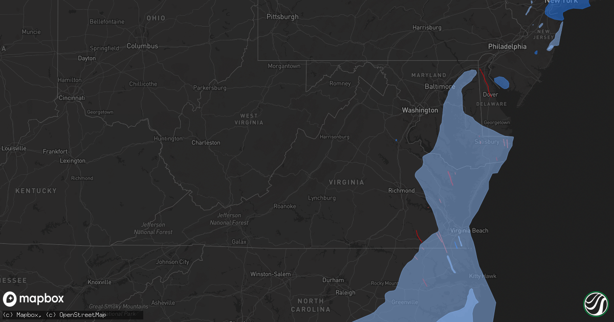
Hail Map in Virginia on August 3, 2020
Get this storm
August 3 map
$229
one time, instant access
Download today. No call, no setup
Keep the $229
Bought the map and want the full workflow? Apply the entire $229 to a subscription within 7 days. None of it is wasted.
Every map, not just this one
This buys you this map. Subscription and you get every map we run, in the markets you choose from a few cities to whole states to nationwide. Plus real-time alerts the moment a storm fires.
Contact data
Name, contact info, occupancy, even credit band for addresses in the footprint. You go from where it hit to who to call.
Become the source they trust
Unlimited branding weather history reports on demand. You already have the documented answer ready for the property owner, and you are the one who showed up with it.
Property data and RoofTrace estimates
Pull up any address you have got, its value and the exact code rules for that jurisdiction, straight from One Click Code. Then RoofTrace estimates the squares, pitch, and roof value, priced the way you price.
Storm reports in Virginia
Virginia
| Date | Description |
|---|---|
| 08/03/20203:49 PM CDT | Tree down in the 11300 block of homeland road. |
| 08/03/20203:43 PM CDT | Trees and wires down near annandale and merrifield... Including near the intersection of whispering lane and watkins trail... And on va-699 prosperity avenue near us-50 |
| 08/03/20203:27 PM CDT | Tree down at the intersection of massaponax church rd and smith station rd. |
| 08/03/20203:12 PM CDT | A tree fell onto a car in the 4000 block of us-522 zachary taylor highway. |
| 08/03/20202:34 PM CDT | Tree down near 729 walnut dr. |
| 08/03/20202:31 PM CDT | Tree down near 120 river rd. |
| 08/03/20202:27 PM CDT | Tree down at the intersection of caledon rd and garcia ct |
| 08/03/20202:25 PM CDT | Tree down at the intersection of muscoe place and comorn road |
| 08/03/20202:22 PM CDT | Tree down at the intersection of massaponax church rd and smith station rd. |
| 08/03/20202:22 PM CDT | Tree down at 5979 partlow rd. |
| 08/03/20202:20 PM CDT | Tree down on us-17 tidewater trail near the spotsylvania/caroline county line. |
| 08/03/20202:13 PM CDT | Tree down at the intersection of muscoe place and comorn road |
| 08/03/20201:18 PM CDT | Tree down at the intersection of hope rd and somerset ln. |
| 08/03/202012:55 PM CDT | Tree on power line in the 500 block of dillons fork road. |
| 08/03/202012:52 PM CDT | Multiple reports of trees down at the intersection of trustlow rd and poplar rd. |
| 08/03/202012:48 PM CDT | Tree down at 92 east river bend dr. |
| 08/03/202012:40 PM CDT | Tree down at the intersection of soapstone road and chestnut knob road. |
| 08/03/202012:31 PM CDT | Tree down across plantation drive. |
| 08/03/202012:14 PM CDT | Tree down at the intersection of swain and chatham rd.. |
| 08/03/20205:08 AM CDT | Nws storm survey confirmed an ef1 tornado with a peak wind speed of 105 mph occurred near the town of fleeton in northumberland county... Va. The tornado occurred from |
| 08/03/20205:07 AM CDT | Damage in the fleeton and buzzard point area. |
| 08/03/20204:57 AM CDT | Tornado damage in the browns store area. |
| 08/03/20204:47 AM CDT | Serious damage on waverly avenue and rt. 200 in kilmarnock. |
| 08/03/20204:45 AM CDT | *** 5 inj *** nws storm survey confirmed an ef2 tornado with a peak wind speed of 135 mph occurred from lancaster county... Va into northumberland county... Va. The tor |
| 08/03/20204:42 AM CDT | *** 2 inj *** significant structural damage along tornado path in eastern lancaster county. |
| 08/03/20203:57 AM CDT | Nws storm survey confirmed an ef1 tornado with a peak wind speed of 90 to 95 mph tracked across gloucester county near middle peninsula state park. The tornado likely t |
| 08/03/20203:55 AM CDT | Trees down and damaged houses in the abingdon area of gloucester county. |
| 08/03/20203:14 AM CDT | Numerous trees down near two rivers country club. |
| 08/03/20203:13 AM CDT | Nws storm survey confirmed an ef1 tornado with a peak wind speed of 90 mph occurred at governors land at two rivers in james city county... Va. The tornado occurred aro |
| 08/03/20202:17 AM CDT | Nws storm survey confirmed an ef1 tornado with a peak wind speed of 100 mph tracked from northern pasquotank county... Nc through the city of suffolk... Va... Including |
| 08/03/20202:15 AM CDT | Numerous trees and power lines down... Along with roof damage to many houses in downtown suffolk. Time estimated. |
| 08/03/20202:13 AM CDT | Nws storm survey confirmed an ef0 tornado with a peak wind speed of 80 mph occurred in the city of suffolk just west of downtown suffolk. The tornado touched down just |
| 08/03/20201:56 AM CDT | Major damage to structures and trees down along along business route 58 in courtland. |
| 08/03/20201:55 AM CDT | Nws storm survey confirmed an ef2 tornado with peak wind speed of 120 to 125 mph tracked across southampton county... Va near the town of courtland. The tornado touched |
| 08/02/202010:55 PM CDT | At 355 PM EDT, severe thunderstorms were located along a line extending from 6 miles northwest of Boswells Tavern to near Orange to 9 miles northeast of Mineral, moving north at 35 mph. HAZARD...60 mph wind gusts. SOURCE...Radar indicated. IMPACT...Damaging winds will cause some trees and large branches to fall. This could injure those outdoors, as well as damage homes and vehicles. Roadways may become blocked by downed trees. Localized power outages are possible. Unsecured light objects may become projectiles. Locations impacted include... Culpeper, Orange, Madison, Gordonsville, Brightwood, Catalpa, Stevensburg, Eheart, Brandy Station, Oakpark, Barboursville, Everona, Verdiersville, Haywood, Montpelier Station, Syria, Thornhill, Nasons, Winston and Banco. |
| 08/02/202010:32 PM CDT | At 331 AM EDT, a severe thunderstorm was located just southeast of Cana near the North Carolina/Virginia border, moving northeast at 25 mph. HAZARD...60 mph wind gusts and quarter size hail. SOURCE...Radar indicated. IMPACT...Hail damage to vehicles is expected. Expect wind damage to roofs, siding, and trees. Locations impacted include... Mount Airy... Fancy Gap... Ararat... Cana... Dugspur... Laurel Fork... and Lambsburg. |
| 08/02/20209:31 PM CDT | At 230 PM EDT, a severe thunderstorm was located over Western Smith Mountain Lake, or 7 miles northwest of Penhook, moving northeast at 30 mph. HAZARD...60 mph wind gusts. SOURCE...Radar indicated. IMPACT...Expect damage to roofs, siding, and trees. Locations impacted include... Bedford... Huddleston... Montvale... Moneta... Penhook... Forest... and Burnt Chimney.This includes The following Location The National D-Day Memorial. |
| 08/02/20209:22 PM CDT | At 222 PM EDT, a severe thunderstorm was located 10 miles east of Orange, moving northeast at 15 mph. HAZARD...60 mph wind gusts and quarter size hail. SOURCE...Radar indicated. IMPACT...Damaging winds will cause some trees and large branches to fall. This could injure those outdoors, as well as damage homes and vehicles. Roadways may become blocked by downed trees. Localized power outages are possible. Unsecured light objects may become projectiles. Locations impacted include... Raccoon Ford, Mine Run, Stevensburg, Rhoadesville, Everona, Verdiersville, Burr Hill, Locust Grove, Flat Run, Lignum, Lahore, Lake Of The Woods and Unionville. |
| 08/02/20208:47 PM CDT | At 146 PM EDT, a severe thunderstorm was located near Fredericksburg, moving northeast at 10 mph. HAZARD...60 mph wind gusts and quarter size hail. SOURCE...Radar indicated. IMPACT...Damaging winds will cause some trees and large branches to fall. This could injure those outdoors, as well as damage homes and vehicles. Roadways may become blocked by downed trees. Localized power outages are possible. Unsecured light objects may become projectiles. Locations impacted include... Stafford, Fredericksburg, Falmouth, Leeland, Roseville, Brooke, Ramoth, Storck, Holly Corner, Dunavant, Glendie, Hartwood, Ruby and Spring Valley. |
All States Impacted by Hail Map on August 3, 2020
Cities Impacted by Hail Map on August 3, 2020
- Fredericksburg, VA
- La Veta, CO
- Weston, CO
- Fort Garland, CO
- Elizabeth, CO
- Kiowa, CO
- Parker, CO
- Raton, NM
- Branson, CO
- Trinchera, CO
- Springfield, CO
- Pritchett, CO
- Gaylesville, AL
- Mentone, AL
- Centre, AL
- Cedar Bluff, AL
- Rome, GA
- Anniston, AL
- Fairmount, GA
- Plainville, GA
- Armuchee, GA
- Adairsville, GA
- Calhoun, GA
- Rydal, GA
- Gainesville, GA
- Flowery Branch, GA
- Kaycee, WY
- Bosler, WY
- Wheatland, WY
- Belle Haven, VA
- Salisbury, MD
- Rose Hill, NC
- Powells Point, NC
- Ahoskie, NC
- Hallieford, VA
- Point Harbor, NC
- Grandy, NC
- Elizabeth City, NC
- Solomons, MD
- Kure Beach, NC
- Maple Hill, NC
- Rich Square, NC
- Horntown, VA
- Cobbs Creek, VA
- Bolton, NC
- Fayetteville, NC
- Avenue, MD
- Oak City, NC
- Wallops Island, VA
- Willards, MD
- Onemo, VA
- Federalsburg, MD
- Abell, MD
- Trappe, MD
- Linkwood, MD
- Columbia, NC
- Kilmarnock, VA
- New Church, VA
- Edward, NC
- Carrollton, VA
- Hubert, NC
- Seven Springs, NC
- Nags Head, NC
- King And Queen Court House, VA
- Wake, VA
- Bethel, DE
- Gibson Island, MD
- Albertson, NC
- Melfa, VA
- Grantsboro, NC
- Kinsale, VA
- Fremont, NC
- Eden, MD
- Council, NC
- Plymouth, NC
- Gatesville, NC
- Hebron, MD
- North Beach, MD
- Wilmington, NC
- Callao, VA
- Teachey, NC
- Moyock, NC
- Easton, MD
- Claiborne, MD
- Fruitland, MD
- Creswell, NC
- Salemburg, NC
- Virginia Beach, VA
- Montross, VA
- Scotland, MD
- Great Mills, MD
- Winnabow, NC
- Chester, MD
- Marshallberg, NC
- Windsor, NC
- North, VA
- Bladenboro, NC
- Deep Run, NC
- Chinquapin, NC
- Pollocksville, NC
- Tall Timbers, MD
- Stedman, NC
- Surry, VA
- Bolivia, NC
- Moon, VA
- Atlantic, NC
- Mattaponi, VA
- Deale, MD
- Pawleys Island, SC
- Broomes Island, MD
- Wittman, MD
- Ocean Isle Beach, NC
- Burgess, VA
- Lusby, MD
- Bethel, NC
- Deltaville, VA
- Laurel, DE
- Frisco, NC
- Dudley, NC
- Harkers Island, NC
- Manteo, NC
- Avon, NC
- Hollywood, MD
- Oriental, NC
- Delmar, MD
- Churchton, MD
- Owings, MD
- Center Cross, VA
- Deal Island, MD
- Seaford, DE
- Lake Waccamaw, NC
- Delmar, DE
- Galesville, MD
- Royal Oak, MD
- Aylett, VA
- Garland, NC
- Maple, NC
- Painter, VA
- Longwood, NC
- Warwick, MD
- Hurlock, MD
- Ayden, NC
- Arapahoe, NC
- Hallwood, VA
- West Point, VA
- Nanticoke, MD
- Willard, NC
- Saint Michaels, MD
- Hartfield, VA
- New Kent, VA
- Hamilton, NC
- Oxford, MD
- Shacklefords, VA
- Foster, VA
- Farmville, NC
- Kitty Hawk, NC
- Jacksonville, NC
- Gloucester Point, VA
- Murfreesboro, NC
- Gunpowder, MD
- Ernul, NC
- Grimesland, NC
- Tracys Landing, MD
- Williamsburg, VA
- Poplar Branch, NC
- Valley Lee, MD
- Snow Hill, NC
- Riegelwood, NC
- Drayden, MD
- South Mills, NC
- Colerain, NC
- Merry Hill, NC
- Gates, NC
- Hatteras, NC
- Queenstown, MD
- Kenansville, NC
- Lanexa, VA
- Dameron, MD
- Lexington Park, MD
- Bloxom, VA
- Hayes, VA
- Dunnsville, VA
- Merritt, NC
- Belhaven, NC
- Hampstead, NC
- Prince Frederick, MD
- Harrellsville, NC
- La Grange, NC
- Onley, VA
- Jamesville, NC
- Salvo, NC
- Georgetown, SC
- Dover, NC
- Conway, SC
- Atlantic, VA
- Atlantic Beach, NC
- Tyner, NC
- Hookerton, NC
- Barco, NC
- Whiteville, NC
- Aberdeen Proving Ground, MD
- Hobbsville, NC
- Rhodesdale, MD
- Roper, NC
- Girdletree, MD
- Hacksneck, VA
- Murrells Inlet, SC
- Still Pond, MD
- King William, VA
- Delco, NC
- Selbyville, DE
- Quantico, MD
- Stokes, NC
- Bath, NC
- Colonial Beach, VA
- Laneview, VA
- Vanceboro, NC
- Wingate, MD
- Frankford, DE
- Carolina Beach, NC
- Newton Grove, NC
- Princess Anne, MD
- Southport, NC
- Beaufort, NC
- Oak Island, NC
- Gloucester, VA
- Cambridge, MD
- Davis, NC
- Farnham, VA
- Champlain, VA
- Smithfield, VA
- Carrsville, VA
- Engelhard, NC
- Shady Side, MD
- Corolla, NC
- Tangier, VA
- Pinetops, NC
- Mcdaniel, MD
- Preston, MD
- Stacy, NC
- Lewiston Woodville, NC
- Stantonsburg, NC
- Bayboro, NC
- Withams, VA
- Suffolk, VA
- Scranton, NC
- North East, MD
- Turkey, NC
- Chestertown, MD
- Betterton, MD
- Mears, VA
- Tilghman, MD
- Burgaw, NC
- Chesapeake City, MD
- Saint Inigoes, MD
- Lancaster, VA
- Yorktown, VA
- Washington, NC
- Midway Park, NC
- Cardinal, VA
- Dutton, VA
- Parksley, VA
- Port Haywood, VA
- Windsor, VA
- Winton, NC
- Wanchese, NC
- Norfolk, VA
- Fairfield, NC
- Roxobel, NC
- Emerald Isle, NC
- Gwynn, VA
- Wallace, NC
- Saluda, VA
- Chesapeake, VA
- Fort Monroe, VA
- Mardela Springs, MD
- Tappahannock, VA
- Crisfield, MD
- Stella, NC
- Greenbush, VA
- North Myrtle Beach, SC
- Mount Olive, NC
- Stevensville, MD
- Callaway, MD
- Warsaw, NC
- Showell, MD
- Clements, MD
- Toddville, MD
- Pinetown, NC
- Rock Hall, MD
- Benson, NC
- East New Market, MD
- Sanford, VA
- Cedar Island, NC
- Mascot, VA
- Macclesfield, NC
- Eure, NC
- Four Oaks, NC
- California, MD
- Centreville, MD
- Shiloh, NC
- Neavitt, MD
- Stockton, MD
- Fishing Creek, MD
- Water View, VA
- Newsoms, VA
- Weems, VA
- Smyrna, NC
- Bivalve, MD
- Nakina, NC
- Urbanna, VA
- Waves, NC
- Princeton, NC
- Sherwood, MD
- Rodanthe, NC
- Woodland, NC
- Ridge, MD
- Ewell, MD
- Worton, MD
- Walkerton, VA
- Temperanceville, VA
- Bozman, MD
- Maysville, NC
- Franklin, VA
- Assawoman, VA
- Coltons Point, MD
- Park Hall, MD
- Millsboro, DE
- Edgewater, MD
- Sealevel, NC
- Goldsboro, NC
- Stumpy Point, NC
- Swanquarter, NC
- Pasadena, MD
- Hertford, NC
- Vienna, MD
- Reedville, VA
- Little River, SC
- Autryville, NC
- Topping, VA
- Greenbackville, VA
- Faison, NC
- Barhamsville, VA
- Salter Path, NC
- Magnolia, NC
- Camden, NC
- White Stone, VA
- Church Creek, MD
- Clarendon, NC
- Hobucken, NC
- Loris, SC
- Sneads Ferry, NC
- Quinby, VA
- Edenton, NC
- Parsonsburg, MD
- Accomac, VA
- Taylors Island, MD
- Robersonville, NC
- Holly Ridge, NC
- Sunset Beach, NC
- Clinton, NC
- Bruington, VA
- Ash, NC
- Stevensville, VA
- Sunderland, MD
- Secretary, MD
- Harrells, NC
- Church View, VA
- Sparrows Point, MD
- Marion Station, MD
- Buxton, NC
- Ocean City, MD
- Elberon, VA
- Atkinson, NC
- Elkton, MD
- Corapeake, NC
- Mechanicsville, MD
- Piney Point, MD
- Lowland, NC
- Vandemere, NC
- Harbinger, NC
- Nassawadox, VA
- Wilson, NC
- Lottsburg, VA
- Mathews, VA
- Beulaville, NC
- McClellanville, SC
- Saint Stephens Church, VA
- Dowell, MD
- West River, MD
- Kelly, NC
- Cove City, NC
- Swansboro, NC
- Grifton, NC
- Little Plymouth, VA
- Warsaw, VA
- Currituck, NC
- Conway, NC
- Franktown, VA
- Chincoteague Island, VA
- Chocowinity, NC
- Irvington, VA
- Newport News, VA
- Whaleyville, MD
- Castle Hayne, NC
- Annapolis, MD
- Kennedyville, MD
- Coinjock, NC
- Longs, SC
- Leland, NC
- Myrtle Beach, SC
- Greenville, NC
- Como, NC
- Westover, MD
- Supply, NC
- Hardyville, VA
- Ocracoke, NC
- Chadbourn, NC
- Hobgood, NC
- Camp Lejeune, NC
- Birdsnest, VA
- Shawboro, NC
- Madison, MD
- Pink Hill, NC
- Winterville, NC
- Earleville, MD
- Fountain, NC
- Tyaskin, MD
- New Bern, NC
- Walstonburg, NC
- Pittsville, MD
- Manns Harbor, NC
- Currie, NC
- Cape Charles, VA
- Belvidere, NC
- Kill Devil Hills, NC
- Tarawa Terrace, NC
- Perryville, MD
- Aulander, NC
- Woolford, MD
- Kelford, NC
- Pikeville, NC
- Crapo, MD
- Hemingway, SC
- Cofield, NC
- Jarvisburg, NC
- Saint Leonard, MD
- Toano, VA
- Newport, NC
- Sharptown, MD
- Sunbury, NC
- Portsmouth, VA
- Exmore, VA
- Loveville, MD
- Tabor City, NC
- Calypso, NC
- Chesapeake Beach, MD
- Tarboro, NC
- Arnold, MD
- Morehead City, NC
- Knotts Island, NC
- Aydlett, NC
- Williamston, NC
- Seaford, VA
- Diggs, VA
- Blounts Creek, NC
- Grasonville, MD
- Wrightsville Beach, NC
- Port Republic, MD
- Calabash, NC
- Trenton, NC
- Aurora, NC
- Crocheron, MD
- Bohannon, VA
- Clarkton, NC
- Elizabethtown, NC
- Fort Eustis, VA
- Patuxent River, MD
- Hague, VA
- Pantego, NC
- Oak Hall, VA
- Richlands, NC
- Leonardtown, MD
- Shallotte, NC
- Dunn, NC
- Berlin, MD
- Scotland Neck, NC
- Snow Hill, MD
- Jamaica, VA
- Ivanhoe, NC
- Heathsville, VA
- Havelock, NC
- Machipongo, VA
- Locust Hill, VA
- Kinston, NC
- Newark, MD
- Hallsboro, NC
- Elm City, NC
- Huntingtown, MD
- Onancock, VA
- Susan, VA
- Friendship, MD
- Roseboro, NC
- Harwood, MD
- Rocky Point, NC
- Bishopville, MD
- Godwin, NC
- Gloucester, NC
- Poquoson, VA
- Hudgins, VA
- Hampton, VA
- Pocomoke City, MD
- Greenwich, NJ
- Bridgeton, NJ
- Millville, NJ
- Cedarville, NJ
- Newport, NJ
- Port Norris, NJ
- Woodbury, NY
- Hazlet, NJ
- Lawrence, NY
- New Haven, CT
- Irvington, NJ
- Roosevelt, NY
- Nutley, NJ
- Huntington Station, NY
- Teterboro, NJ
- Carteret, NJ
- Sewaren, NJ
- Red Bank, NJ
- Merrick, NY
- Richmond Hill, NY
- Hastings On Hudson, NY
- Maywood, NJ
- Queens Village, NY
- Port Washington, NY
- South Ozone Park, NY
- Pelham, NY
- Bogota, NJ
- South Amboy, NJ
- Fairfield, CT
- Closter, NJ
- Bronx, NY
- Bayonne, NJ
- Inwood, NY
- Greenvale, NY
- Newark, NJ
- College Point, NY
- Holmdel, NJ
- Hewlett, NY
- Port Chester, NY
- Lynbrook, NY
- Mill Neck, NY
- Middle Village, NY
- Manhasset, NY
- Union, NJ
- Ridgewood, NY
- Leonia, NJ
- Roselle, NJ
- Elmont, NY
- North Bergen, NJ
- Jersey City, NJ
- Saint Albans, NY
- White Plains, NY
- Ridgefield Park, NJ
- Carlstadt, NJ
- Woodmere, NY
- New Milford, NJ
- Cambria Heights, NY
- Bayville, NY
- East Rutherford, NJ
- Rockville Centre, NY
- Weehawken, NJ
- Staten Island, NY
- Roselle Park, NJ
- Hasbrouck Heights, NJ
- Purchase, NY
- Wood Ridge, NJ
- Kew Gardens, NY
- Glen Head, NY
- East Rockaway, NY
- Oceanside, NY
- Rutherford, NJ
- Bayside, NY
- Hackensack, NJ
- Hoboken, NJ
- Hillside, NJ
- Westport, CT
- Rumson, NJ
- Bellmore, NY
- Edgewater, NJ
- Breezy Point, NY
- Clifton, NJ
- Rahway, NJ
- Sea Cliff, NY
- Fort Lee, NJ
- Atlantic Highlands, NJ
- Perth Amboy, NJ
- Harrison, NJ
- Westbury, NY
- Malverne, NY
- Maspeth, NY
- Massapequa, NY
- Port Monmouth, NJ
- Haworth, NJ
- Parlin, NJ
- Melville, NY
- Fairview, NJ
- Point Lookout, NY
- Cresskill, NJ
- Demarest, NJ
- Trumbull, CT
- East Norwich, NY
- Hicksville, NY
- Lyndhurst, NJ
- East Haven, CT
- River Edge, NJ
- Elmhurst, NY
- Whitestone, NY
- East Elmhurst, NY
- Hollis, NY
- Eastchester, NY
- Long Beach, NY
- Port Reading, NJ
- Norwalk, CT
- Far Rockaway, NY
- Garden City, NY
- Oyster Bay, NY
- Jamaica, NY
- Glen Cove, NY
- East Meadow, NY
- Tuckahoe, NY
- Middletown, NJ
- Harrison, NY
- Cedarhurst, NY
- Greenwich, CT
- Larchmont, NY
- Sunnyside, NY
- Belford, NJ
- Wantagh, NY
- Williston Park, NY
- Teaneck, NJ
- Floral Park, NY
- New Hyde Park, NY
- Babylon, NY
- Moonachie, NJ
- Elizabeth, NJ
- Albertson, NY
- Bellerose, NY
- Elizabethport, NJ
- Woodside, NY
- Scarsdale, NY
- Arverne, NY
- Carle Place, NY
- Alpine, NJ
- Cos Cob, CT
- South Richmond Hill, NY
- Franklin Square, NY
- Matawan, NJ
- Highlands, NJ
- Rockaway Park, NY
- Sayreville, NJ
- Long Island City, NY
- Tenafly, NJ
- Rosedale, NY
- Springfield Gardens, NY
- Glen Oaks, NY
- Edison, NJ
- Cold Spring Harbor, NY
- Brooklyn, NY
- Massapequa Park, NY
- Amityville, NY
- Mineola, NY
- Southport, CT
- Milford, CT
- Mount Vernon, NY
- New York, NY
- Stratford, CT
- Keyport, NJ
- Oakland Gardens, NY
- Ridgefield, NJ
- Bridgeport, CT
- Roslyn, NY
- Forest Hills, NY
- Old Westbury, NY
- Huntington, NY
- Rye, NY
- Palisades Park, NJ
- Darien, CT
- Ozone Park, NY
- Island Park, NY
- Jericho, NY
- South Hackensack, NJ
- Howard Beach, NY
- Avenel, NJ
- Astoria, NY
- Fresh Meadows, NY
- West Hempstead, NY
- Roslyn Heights, NY
- Jackson Heights, NY
- Woodhaven, NY
- Lodi, NJ
- New Rochelle, NY
- Colonia, NJ
- Freeport, NY
- Flushing, NY
- Metuchen, NJ
- Uniondale, NY
- Mamaroneck, NY
- Little Ferry, NJ
- Secaucus, NJ
- Iselin, NJ
- Englewood, NJ
- Little Neck, NY
- Great Neck, NY
- Seaford, NY
- Wallington, NJ
- Bergenfield, NJ
- Norwood, NJ
- Baldwin, NY
- Plainview, NY
- Dumont, NJ
- Englewood Cliffs, NJ
- East Orange, NJ
- Orange, CT
- Yonkers, NY
- West Harrison, NY
- Locust Valley, NY
- Bronxville, NY
- Old Bethpage, NY
- Atlantic Beach, NY
- Kearny, NJ
- Glenwood Landing, NY
- Cliffside Park, NJ
- Syosset, NY
- Corona, NY
- Stamford, CT
- Union City, NJ
- New Canaan, CT
- North Arlington, NJ
- Valley Stream, NY
- Belleville, NJ
- Bloomfield, NJ
- Farmingdale, NY
- Keasbey, NJ
- Linden, NJ
- Keansburg, NJ
- Cliffwood, NJ
- Fords, NJ
- Rego Park, NY
- Clark, NJ
- Levittown, NY
- Leonardo, NJ
- Old Greenwich, CT
- Hempstead, NY
- West New York, NJ
- West Haven, CT
- Bethpage, NY
- Riverside, CT
- Woodbridge, NJ
- West Hartford, CT
- Portland, CT
- Hartford, CT
- Wethersfield, CT
- Rocky Hill, CT
- Higganum, CT
- Newington, CT
- Cromwell, CT
- Bloomfield, CT
- Windsor, CT
- Middletown, CT
- Princeton Junction, NJ
- Monroe Township, NJ
- Hightstown, NJ
- Bridgewater, NJ
- Hillsborough, NJ
- Neshanic Station, NJ
- Somerville, NJ
- Peapack, NJ
- Bedminster, NJ
- Far Hills, NJ
- Basking Ridge, NJ
- Chester, NJ
- Boonton, NJ
- Pine Brook, NJ
- Lake Hiawatha, NJ
- Montville, NJ
- Parsippany, NJ
- East Hanover, NJ
- Towaco, NJ
- Centerport, NY
- Greenlawn, NY
- East Northport, NY
- Northport, NY
- Commack, NY
- Hopewell Junction, NY
- Lagrangeville, NY
- Poughquag, NY
- Holmes, NY
- Stormville, NY
- Patterson, NY
- Brewster, NY
- Carmel, NY
- Middlebury, CT
- Oxford, CT
- Woodbury, CT
- Southbury, CT
- Naugatuck, CT
- Watertown, CT
- Waterbury, CT
- Oakville, CT
- Bristol, CT
- Harwinton, CT
- New Hartford, CT
- Burlington, CT
- Winsted, CT
- Torrington, CT
- East Hartford, CT
- South Windsor, CT
- East Windsor, CT
- West Suffield, CT
- Southwick, MA
- Enfield, CT
- Windsor Locks, CT
- East Granby, CT
- Manchester, CT
- Feeding Hills, MA
- Suffield, CT
- Broad Brook, CT
- Westfield, MA
- Huntington, MA
- Russell, MA
- Chester, MA
- Worthington, MA
- Granby, MA
- South Hadley, MA
- Amherst, MA
- Belchertown, MA
- Hadley, MA
- Marlborough, CT
- Glastonbury, CT
- Hebron, CT
- Andover, CT
- Lebanon, CT
- Columbia, CT
- Bolton, CT
- Colchester, CT
- Amston, CT
- Coventry, CT
- Blandford, MA
- Holyoke, MA
- Chicopee, MA
- Agawam, MA
- Springfield, MA
- West Springfield, MA
- Courtland, VA
- Bear, DE
- Odessa, DE
- Middletown, DE
- Townsend, DE
- Dover, DE
- Smyrna, DE
- Gravel Switch, KY
- Harrodsburg, KY
- Perryville, KY
- Danville, KY
- Junction City, KY
- Parksville, KY
- Livingston, MT
- Columbus, MT
- Molt, MT
- Park City, MT
- Laurel, MT
- Billings, MT
- Rainsville, NM
- Buena Vista, NM
- Ocate, NM
- Sapello, NM
- Moriarty, NM
- Ribera, NM
- Cimarron, NM
- Las Vegas, NM
- Serafina, NM
- San Jose, NM
- Albuquerque, NM
- Tijeras, NM
- Edgewood, NM
- Corrales, NM
- Gallatin Gateway, MT
- Lewistown, MT
- Manhattan, MT
- Bozeman, MT
- Ranger, GA
- Atlanta, GA
- Fairburn, GA
- Dacula, GA
- Hoschton, GA
- Buford, GA
- Auburn, GA
- Conyers, GA
- Lincolnton, GA
- Chatsworth, NJ
- Vincentown, NJ
- Toms River, NJ
- Point Pleasant Beach, NJ
- Bayville, NJ
- Manasquan, NJ
- Deal, NJ
- Ocean Grove, NJ
- Manchester Township, NJ
- Avon By The Sea, NJ
- Asbury Park, NJ
- Allenhurst, NJ
- Lavallette, NJ
- Sea Girt, NJ
- Allenwood, NJ
- Long Branch, NJ
- Lakewood, NJ
- Belmar, NJ
- Brick, NJ
- Neptune, NJ
- Monmouth Beach, NJ
- Bradley Beach, NJ
- Oceanport, NJ
- Spring Lake, NJ
- Mantoloking, NJ
- Forked River, NJ
- Farmingdale, NJ
- Beachwood, NJ
- West Long Branch, NJ
- Oakhurst, NJ
- Howell, NJ
- Brielle, NJ
- Big Timber, MT
- Floweree, MT
- Great Falls, MT
- Buffalo, WY
- Aguilar, CO
- Moscow, KS
- Lance Creek, WY
- Lead, SD
- Spearfish, SD
- Kim, CO
- Custer, SD
- Belle Fourche, SD
- Bad Axe, MI
- Fort Benton, MT
- Embudo, NM
- Hernandez, NM
- Dawsonville, GA
- Mora, NM
- White, GA
- Cumming, GA
- Cleveland, NM
- Resaca, GA
- Chatsworth, GA


