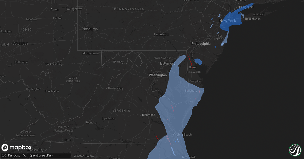
Hail Map in Maryland on August 3, 2020
Get this storm
August 3 map
$229
one time, instant access
Download today. No call, no setup
Keep the $229
Bought the map and want the full workflow? Apply the entire $229 to a subscription within 7 days. None of it is wasted.
Every map, not just this one
This buys you this map. Subscription and you get every map we run, in the markets you choose from a few cities to whole states to nationwide. Plus real-time alerts the moment a storm fires.
Contact data
Name, contact info, occupancy, even credit band for addresses in the footprint. You go from where it hit to who to call.
Become the source they trust
Unlimited branding weather history reports on demand. You already have the documented answer ready for the property owner, and you are the one who showed up with it.
Property data and RoofTrace estimates
Pull up any address you have got, its value and the exact code rules for that jurisdiction, straight from One Click Code. Then RoofTrace estimates the squares, pitch, and roof value, priced the way you price.
Storm reports in Maryland
Maryland
| Date | Description |
|---|---|
| 08/03/20203:15 PM CDT | Tree down on us-301 crain hgwy at dyson rd |
| 08/03/20203:14 PM CDT | Trees down in the area of md-382 croom road and molly berry road. |
| 08/03/20202:55 PM CDT | Tree down near the intersection of hampshire circle and gray wolf court |
| 08/03/20202:47 PM CDT | Tree down in the 8000 block of kentucky avenue |
| 08/03/20202:43 PM CDT | Powerlines down near the intersection of bayside road and bailey drive |
| 08/03/20202:40 PM CDT | Tree down in the 8000 block of kentucky avenue |
| 08/03/20202:32 PM CDT | Tree down in the 1300 block of saunders marina place |
| 08/03/20202:22 PM CDT | Tree down in the 1300 block of saunders marina place |
| 08/03/20206:47 AM CDT | Trees down and sheared off. Possible tornado. |
| 08/03/20206:39 AM CDT | Nws storm survey confirmed an ef0 tornado with a peak wind speed of 70 mph occurred in worcester county... Md near the town of berlin. The tornado occurred from about 7 |
| 08/03/20206:35 AM CDT | Multiple trees reported down in the willow beach colony area. |
| 08/03/20206:23 AM CDT | Downed trees... Gutter... And fence damage consistent with a brief ef0 tornado at country club south and the green hill country club near quantico in wicomico county... |
| 08/03/20206:17 AM CDT | Tree and home damage. Possible tornado. |
| 08/03/20206:15 AM CDT | Nws storm survey confirmed an ef2 tornado with a peak wind speed of 115 mph occurred near stockton in worcester county... Md. The tornado occurred from about 7:14 am to |
| 08/03/20206:11 AM CDT | Law enforcement reports trees and power lines down... Along with some structural damage. |
| 08/03/20205:46 AM CDT | Multiple trees reported down along with damage to house. |
| 08/03/20205:46 AM CDT | Multiple trees reported down... With several falling onto trees and cars in the same area. |
| 08/03/20205:30 AM CDT | Prelim info from nws storm survey... Will be revised in report issued wed. Ef-1 tornado confirmed. Peak wind 100mph. Path length 7.3 mi. Path width 100yds. Time on grou |
| 08/03/20205:27 AM CDT | Prelim info from nws storm survey... Will be revised in report issued wed. Ef-0 tornado confirmed. Peak wind 80 mph. Path length 0.9 mi. Path width 75 yards. Time on gr |
| 08/03/20204:59 AM CDT | Nws storm survey confirmed an ef2 tornado with a peak wind speed of 125 mph occurred at mardela springs in wicomico county... Md. The tornado occurred from about 5:55 a |
| 08/03/20204:50 AM CDT | Trained spotter reported tornado on the ground near route 50. |
| 08/02/202010:39 PM CDT | At 337 PM EDT, severe thunderstorms were located along a line extending from near Spotsylvania to near Aquia Creek to near Popes Creek, moving north at 25 mph. HAZARD...Scattered damagin wind gusts up to 60 mph. SOURCE...Radar indicated. IMPACT...Damaging winds will cause some trees and large branches to fall. This could injure those outdoors, as well as damage homes and vehicles. Roadways may become blocked by downed trees. Localized power outages are possible. Unsecured light objects may become projectiles. Locations impacted include... Stafford, Waldorf, Dale City, Clinton, Springfield, Fort Washington, Fort Hunt, Groveton, La Plata, Fort Belvoir, Woodbridge, National Harbor, Upper Marlboro, Quantico, Andrews Air Force Base, Lake Ridge, Montclair, Camp Springs, Lorton and Franconia. |
| 08/02/20209:55 PM CDT | At 255 AM EDT, a severe thunderstorm was located near Sheridan Point, moving northeast at 45 mph. HAZARD...60 mph wind gusts. SOURCE...Radar indicated. IMPACT...Damaging winds will cause some trees and large branches to fall. This could injure those outdoors, as well as damage homes and vehicles. Roadways may become blocked by downed trees. Localized power outages are possible. Unsecured light objects may become projectiles. Locations impacted include... Prince Frederick, Hallowing Point, Sheridan Point, Flag Harbor, Golden Beach, Saint Leonard, Long Beach, Mechanicsville, Calvert Beach, Barstow, Port Republic, Sandgates and Dares Beach. |
| 08/02/20209:55 PM CDT | At 255 PM EDT, severe thunderstorms were located along a line extending from 6 miles northeast of Gum Spring to Bowling Green to near White Point Beach, moving northwest at 25 mph. HAZARD...60 mph wind gusts. SOURCE...Radar indicated. IMPACT...Damaging winds will cause some trees and large branches to fall. This could injure those outdoors, as well as damage homes and vehicles. Roadways may become blocked by downed trees. Localized power outages are possible. Unsecured light objects may become projectiles. Locations impacted include... Stafford, Waldorf, Fredericksburg, La Plata, King George, Leonardtown, Dahlgren, Fairview Beach, Popes Creek, Hallowing Point, Aquia Creek, Potomac Creek, Sheridan Point, Saint Clements Bay, Nanjemoy Creek, Wicomico River, White Point Beach, Port Tobacco River, Golden Beach and Massaponax. |
| 08/02/20209:38 PM CDT | At 238 PM EDT, a severe thunderstorm was located over Aquia Creek, moving east at 15 mph. HAZARD...60 mph wind gusts. SOURCE...Radar indicated. IMPACT...Damaging winds will cause some trees and large branches to fall. This could injure those outdoors, as well as damage homes and vehicles. Roadways may become blocked by downed trees. Localized power outages are possible. Unsecured light objects may become projectiles. Locations impacted include... Stafford, Potomac Creek, Aquia Creek, Brooke, Marbury, Nanjemoy, Widewater, Pisgah, Ironsides, Arkendale and Rison. |
| 08/02/20209:13 PM CDT | At 213 AM EDT, a severe thunderstorm was located over Golden Beach, or near Sheridan Point, moving northeast at 30 mph. HAZARD...60 mph wind gusts. SOURCE...Radar indicated. IMPACT...Damaging winds will cause some trees and large branches to fall. This could injure those outdoors, as well as damage homes and vehicles. Roadways may become blocked by downed trees. Localized power outages are possible. Unsecured light objects may become projectiles. Locations impacted include... Chesapeake Beach, Prince Frederick, Hallowing Point, Breezy Point, Sheridan Point, Flag Harbor, Golden Beach, Saint Leonard, Huntingtown, Hughesville, Long Beach, Mechanicsville, Charlotte Hall, Aquasco, Calvert Beach, Benedict, Eagle Harbor, Barstow, Port Republic and Morganza. |
All States Impacted by Hail Map on August 3, 2020
Cities Impacted by Hail Map on August 3, 2020
- Fredericksburg, VA
- La Veta, CO
- Weston, CO
- Fort Garland, CO
- Elizabeth, CO
- Kiowa, CO
- Parker, CO
- Raton, NM
- Branson, CO
- Trinchera, CO
- Springfield, CO
- Pritchett, CO
- Gaylesville, AL
- Mentone, AL
- Centre, AL
- Cedar Bluff, AL
- Rome, GA
- Anniston, AL
- Fairmount, GA
- Plainville, GA
- Armuchee, GA
- Adairsville, GA
- Calhoun, GA
- Rydal, GA
- Gainesville, GA
- Flowery Branch, GA
- Kaycee, WY
- Bosler, WY
- Wheatland, WY
- Belle Haven, VA
- Salisbury, MD
- Rose Hill, NC
- Powells Point, NC
- Ahoskie, NC
- Hallieford, VA
- Point Harbor, NC
- Grandy, NC
- Elizabeth City, NC
- Solomons, MD
- Kure Beach, NC
- Maple Hill, NC
- Rich Square, NC
- Horntown, VA
- Cobbs Creek, VA
- Bolton, NC
- Fayetteville, NC
- Avenue, MD
- Oak City, NC
- Wallops Island, VA
- Willards, MD
- Onemo, VA
- Federalsburg, MD
- Abell, MD
- Trappe, MD
- Linkwood, MD
- Columbia, NC
- Kilmarnock, VA
- New Church, VA
- Edward, NC
- Carrollton, VA
- Hubert, NC
- Seven Springs, NC
- Nags Head, NC
- King And Queen Court House, VA
- Wake, VA
- Bethel, DE
- Gibson Island, MD
- Albertson, NC
- Melfa, VA
- Grantsboro, NC
- Kinsale, VA
- Fremont, NC
- Eden, MD
- Council, NC
- Plymouth, NC
- Gatesville, NC
- Hebron, MD
- North Beach, MD
- Wilmington, NC
- Callao, VA
- Teachey, NC
- Moyock, NC
- Easton, MD
- Claiborne, MD
- Fruitland, MD
- Creswell, NC
- Salemburg, NC
- Virginia Beach, VA
- Montross, VA
- Scotland, MD
- Great Mills, MD
- Winnabow, NC
- Chester, MD
- Marshallberg, NC
- Windsor, NC
- North, VA
- Bladenboro, NC
- Deep Run, NC
- Chinquapin, NC
- Pollocksville, NC
- Tall Timbers, MD
- Stedman, NC
- Surry, VA
- Bolivia, NC
- Moon, VA
- Atlantic, NC
- Mattaponi, VA
- Deale, MD
- Pawleys Island, SC
- Broomes Island, MD
- Wittman, MD
- Ocean Isle Beach, NC
- Burgess, VA
- Lusby, MD
- Bethel, NC
- Deltaville, VA
- Laurel, DE
- Frisco, NC
- Dudley, NC
- Harkers Island, NC
- Manteo, NC
- Avon, NC
- Hollywood, MD
- Oriental, NC
- Delmar, MD
- Churchton, MD
- Owings, MD
- Center Cross, VA
- Deal Island, MD
- Seaford, DE
- Lake Waccamaw, NC
- Delmar, DE
- Galesville, MD
- Royal Oak, MD
- Aylett, VA
- Garland, NC
- Maple, NC
- Painter, VA
- Longwood, NC
- Warwick, MD
- Hurlock, MD
- Ayden, NC
- Arapahoe, NC
- Hallwood, VA
- West Point, VA
- Nanticoke, MD
- Willard, NC
- Saint Michaels, MD
- Hartfield, VA
- New Kent, VA
- Hamilton, NC
- Oxford, MD
- Shacklefords, VA
- Foster, VA
- Farmville, NC
- Kitty Hawk, NC
- Jacksonville, NC
- Gloucester Point, VA
- Murfreesboro, NC
- Gunpowder, MD
- Ernul, NC
- Grimesland, NC
- Tracys Landing, MD
- Williamsburg, VA
- Poplar Branch, NC
- Valley Lee, MD
- Snow Hill, NC
- Riegelwood, NC
- Drayden, MD
- South Mills, NC
- Colerain, NC
- Merry Hill, NC
- Gates, NC
- Hatteras, NC
- Queenstown, MD
- Kenansville, NC
- Lanexa, VA
- Dameron, MD
- Lexington Park, MD
- Bloxom, VA
- Hayes, VA
- Dunnsville, VA
- Merritt, NC
- Belhaven, NC
- Hampstead, NC
- Prince Frederick, MD
- Harrellsville, NC
- La Grange, NC
- Onley, VA
- Jamesville, NC
- Salvo, NC
- Georgetown, SC
- Dover, NC
- Conway, SC
- Atlantic, VA
- Atlantic Beach, NC
- Tyner, NC
- Hookerton, NC
- Barco, NC
- Whiteville, NC
- Aberdeen Proving Ground, MD
- Hobbsville, NC
- Rhodesdale, MD
- Roper, NC
- Girdletree, MD
- Hacksneck, VA
- Murrells Inlet, SC
- Still Pond, MD
- King William, VA
- Delco, NC
- Selbyville, DE
- Quantico, MD
- Stokes, NC
- Bath, NC
- Colonial Beach, VA
- Laneview, VA
- Vanceboro, NC
- Wingate, MD
- Frankford, DE
- Carolina Beach, NC
- Newton Grove, NC
- Princess Anne, MD
- Southport, NC
- Beaufort, NC
- Oak Island, NC
- Gloucester, VA
- Cambridge, MD
- Davis, NC
- Farnham, VA
- Champlain, VA
- Smithfield, VA
- Carrsville, VA
- Engelhard, NC
- Shady Side, MD
- Corolla, NC
- Tangier, VA
- Pinetops, NC
- Mcdaniel, MD
- Preston, MD
- Stacy, NC
- Lewiston Woodville, NC
- Stantonsburg, NC
- Bayboro, NC
- Withams, VA
- Suffolk, VA
- Scranton, NC
- North East, MD
- Turkey, NC
- Chestertown, MD
- Betterton, MD
- Mears, VA
- Tilghman, MD
- Burgaw, NC
- Chesapeake City, MD
- Saint Inigoes, MD
- Lancaster, VA
- Yorktown, VA
- Washington, NC
- Midway Park, NC
- Cardinal, VA
- Dutton, VA
- Parksley, VA
- Port Haywood, VA
- Windsor, VA
- Winton, NC
- Wanchese, NC
- Norfolk, VA
- Fairfield, NC
- Roxobel, NC
- Emerald Isle, NC
- Gwynn, VA
- Wallace, NC
- Saluda, VA
- Chesapeake, VA
- Fort Monroe, VA
- Mardela Springs, MD
- Tappahannock, VA
- Crisfield, MD
- Stella, NC
- Greenbush, VA
- North Myrtle Beach, SC
- Mount Olive, NC
- Stevensville, MD
- Callaway, MD
- Warsaw, NC
- Showell, MD
- Clements, MD
- Toddville, MD
- Pinetown, NC
- Rock Hall, MD
- Benson, NC
- East New Market, MD
- Sanford, VA
- Cedar Island, NC
- Mascot, VA
- Macclesfield, NC
- Eure, NC
- Four Oaks, NC
- California, MD
- Centreville, MD
- Shiloh, NC
- Neavitt, MD
- Stockton, MD
- Fishing Creek, MD
- Water View, VA
- Newsoms, VA
- Weems, VA
- Smyrna, NC
- Bivalve, MD
- Nakina, NC
- Urbanna, VA
- Waves, NC
- Princeton, NC
- Sherwood, MD
- Rodanthe, NC
- Woodland, NC
- Ridge, MD
- Ewell, MD
- Worton, MD
- Walkerton, VA
- Temperanceville, VA
- Bozman, MD
- Maysville, NC
- Franklin, VA
- Assawoman, VA
- Coltons Point, MD
- Park Hall, MD
- Millsboro, DE
- Edgewater, MD
- Sealevel, NC
- Goldsboro, NC
- Stumpy Point, NC
- Swanquarter, NC
- Pasadena, MD
- Hertford, NC
- Vienna, MD
- Reedville, VA
- Little River, SC
- Autryville, NC
- Topping, VA
- Greenbackville, VA
- Faison, NC
- Barhamsville, VA
- Salter Path, NC
- Magnolia, NC
- Camden, NC
- White Stone, VA
- Church Creek, MD
- Clarendon, NC
- Hobucken, NC
- Loris, SC
- Sneads Ferry, NC
- Quinby, VA
- Edenton, NC
- Parsonsburg, MD
- Accomac, VA
- Taylors Island, MD
- Robersonville, NC
- Holly Ridge, NC
- Sunset Beach, NC
- Clinton, NC
- Bruington, VA
- Ash, NC
- Stevensville, VA
- Sunderland, MD
- Secretary, MD
- Harrells, NC
- Church View, VA
- Sparrows Point, MD
- Marion Station, MD
- Buxton, NC
- Ocean City, MD
- Elberon, VA
- Atkinson, NC
- Elkton, MD
- Corapeake, NC
- Mechanicsville, MD
- Piney Point, MD
- Lowland, NC
- Vandemere, NC
- Harbinger, NC
- Nassawadox, VA
- Wilson, NC
- Lottsburg, VA
- Mathews, VA
- Beulaville, NC
- McClellanville, SC
- Saint Stephens Church, VA
- Dowell, MD
- West River, MD
- Kelly, NC
- Cove City, NC
- Swansboro, NC
- Grifton, NC
- Little Plymouth, VA
- Warsaw, VA
- Currituck, NC
- Conway, NC
- Franktown, VA
- Chincoteague Island, VA
- Chocowinity, NC
- Irvington, VA
- Newport News, VA
- Whaleyville, MD
- Castle Hayne, NC
- Annapolis, MD
- Kennedyville, MD
- Coinjock, NC
- Longs, SC
- Leland, NC
- Myrtle Beach, SC
- Greenville, NC
- Como, NC
- Westover, MD
- Supply, NC
- Hardyville, VA
- Ocracoke, NC
- Chadbourn, NC
- Hobgood, NC
- Camp Lejeune, NC
- Birdsnest, VA
- Shawboro, NC
- Madison, MD
- Pink Hill, NC
- Winterville, NC
- Earleville, MD
- Fountain, NC
- Tyaskin, MD
- New Bern, NC
- Walstonburg, NC
- Pittsville, MD
- Manns Harbor, NC
- Currie, NC
- Cape Charles, VA
- Belvidere, NC
- Kill Devil Hills, NC
- Tarawa Terrace, NC
- Perryville, MD
- Aulander, NC
- Woolford, MD
- Kelford, NC
- Pikeville, NC
- Crapo, MD
- Hemingway, SC
- Cofield, NC
- Jarvisburg, NC
- Saint Leonard, MD
- Toano, VA
- Newport, NC
- Sharptown, MD
- Sunbury, NC
- Portsmouth, VA
- Exmore, VA
- Loveville, MD
- Tabor City, NC
- Calypso, NC
- Chesapeake Beach, MD
- Tarboro, NC
- Arnold, MD
- Morehead City, NC
- Knotts Island, NC
- Aydlett, NC
- Williamston, NC
- Seaford, VA
- Diggs, VA
- Blounts Creek, NC
- Grasonville, MD
- Wrightsville Beach, NC
- Port Republic, MD
- Calabash, NC
- Trenton, NC
- Aurora, NC
- Crocheron, MD
- Bohannon, VA
- Clarkton, NC
- Elizabethtown, NC
- Fort Eustis, VA
- Patuxent River, MD
- Hague, VA
- Pantego, NC
- Oak Hall, VA
- Richlands, NC
- Leonardtown, MD
- Shallotte, NC
- Dunn, NC
- Berlin, MD
- Scotland Neck, NC
- Snow Hill, MD
- Jamaica, VA
- Ivanhoe, NC
- Heathsville, VA
- Havelock, NC
- Machipongo, VA
- Locust Hill, VA
- Kinston, NC
- Newark, MD
- Hallsboro, NC
- Elm City, NC
- Huntingtown, MD
- Onancock, VA
- Susan, VA
- Friendship, MD
- Roseboro, NC
- Harwood, MD
- Rocky Point, NC
- Bishopville, MD
- Godwin, NC
- Gloucester, NC
- Poquoson, VA
- Hudgins, VA
- Hampton, VA
- Pocomoke City, MD
- Greenwich, NJ
- Bridgeton, NJ
- Millville, NJ
- Cedarville, NJ
- Newport, NJ
- Port Norris, NJ
- Woodbury, NY
- Hazlet, NJ
- Lawrence, NY
- New Haven, CT
- Irvington, NJ
- Roosevelt, NY
- Nutley, NJ
- Huntington Station, NY
- Teterboro, NJ
- Carteret, NJ
- Sewaren, NJ
- Red Bank, NJ
- Merrick, NY
- Richmond Hill, NY
- Hastings On Hudson, NY
- Maywood, NJ
- Queens Village, NY
- Port Washington, NY
- South Ozone Park, NY
- Pelham, NY
- Bogota, NJ
- South Amboy, NJ
- Fairfield, CT
- Closter, NJ
- Bronx, NY
- Bayonne, NJ
- Inwood, NY
- Greenvale, NY
- Newark, NJ
- College Point, NY
- Holmdel, NJ
- Hewlett, NY
- Port Chester, NY
- Lynbrook, NY
- Mill Neck, NY
- Middle Village, NY
- Manhasset, NY
- Union, NJ
- Ridgewood, NY
- Leonia, NJ
- Roselle, NJ
- Elmont, NY
- North Bergen, NJ
- Jersey City, NJ
- Saint Albans, NY
- White Plains, NY
- Ridgefield Park, NJ
- Carlstadt, NJ
- Woodmere, NY
- New Milford, NJ
- Cambria Heights, NY
- Bayville, NY
- East Rutherford, NJ
- Rockville Centre, NY
- Weehawken, NJ
- Staten Island, NY
- Roselle Park, NJ
- Hasbrouck Heights, NJ
- Purchase, NY
- Wood Ridge, NJ
- Kew Gardens, NY
- Glen Head, NY
- East Rockaway, NY
- Oceanside, NY
- Rutherford, NJ
- Bayside, NY
- Hackensack, NJ
- Hoboken, NJ
- Hillside, NJ
- Westport, CT
- Rumson, NJ
- Bellmore, NY
- Edgewater, NJ
- Breezy Point, NY
- Clifton, NJ
- Rahway, NJ
- Sea Cliff, NY
- Fort Lee, NJ
- Atlantic Highlands, NJ
- Perth Amboy, NJ
- Harrison, NJ
- Westbury, NY
- Malverne, NY
- Maspeth, NY
- Massapequa, NY
- Port Monmouth, NJ
- Haworth, NJ
- Parlin, NJ
- Melville, NY
- Fairview, NJ
- Point Lookout, NY
- Cresskill, NJ
- Demarest, NJ
- Trumbull, CT
- East Norwich, NY
- Hicksville, NY
- Lyndhurst, NJ
- East Haven, CT
- River Edge, NJ
- Elmhurst, NY
- Whitestone, NY
- East Elmhurst, NY
- Hollis, NY
- Eastchester, NY
- Long Beach, NY
- Port Reading, NJ
- Norwalk, CT
- Far Rockaway, NY
- Garden City, NY
- Oyster Bay, NY
- Jamaica, NY
- Glen Cove, NY
- East Meadow, NY
- Tuckahoe, NY
- Middletown, NJ
- Harrison, NY
- Cedarhurst, NY
- Greenwich, CT
- Larchmont, NY
- Sunnyside, NY
- Belford, NJ
- Wantagh, NY
- Williston Park, NY
- Teaneck, NJ
- Floral Park, NY
- New Hyde Park, NY
- Babylon, NY
- Moonachie, NJ
- Elizabeth, NJ
- Albertson, NY
- Bellerose, NY
- Elizabethport, NJ
- Woodside, NY
- Scarsdale, NY
- Arverne, NY
- Carle Place, NY
- Alpine, NJ
- Cos Cob, CT
- South Richmond Hill, NY
- Franklin Square, NY
- Matawan, NJ
- Highlands, NJ
- Rockaway Park, NY
- Sayreville, NJ
- Long Island City, NY
- Tenafly, NJ
- Rosedale, NY
- Springfield Gardens, NY
- Glen Oaks, NY
- Edison, NJ
- Cold Spring Harbor, NY
- Brooklyn, NY
- Massapequa Park, NY
- Amityville, NY
- Mineola, NY
- Southport, CT
- Milford, CT
- Mount Vernon, NY
- New York, NY
- Stratford, CT
- Keyport, NJ
- Oakland Gardens, NY
- Ridgefield, NJ
- Bridgeport, CT
- Roslyn, NY
- Forest Hills, NY
- Old Westbury, NY
- Huntington, NY
- Rye, NY
- Palisades Park, NJ
- Darien, CT
- Ozone Park, NY
- Island Park, NY
- Jericho, NY
- South Hackensack, NJ
- Howard Beach, NY
- Avenel, NJ
- Astoria, NY
- Fresh Meadows, NY
- West Hempstead, NY
- Roslyn Heights, NY
- Jackson Heights, NY
- Woodhaven, NY
- Lodi, NJ
- New Rochelle, NY
- Colonia, NJ
- Freeport, NY
- Flushing, NY
- Metuchen, NJ
- Uniondale, NY
- Mamaroneck, NY
- Little Ferry, NJ
- Secaucus, NJ
- Iselin, NJ
- Englewood, NJ
- Little Neck, NY
- Great Neck, NY
- Seaford, NY
- Wallington, NJ
- Bergenfield, NJ
- Norwood, NJ
- Baldwin, NY
- Plainview, NY
- Dumont, NJ
- Englewood Cliffs, NJ
- East Orange, NJ
- Orange, CT
- Yonkers, NY
- West Harrison, NY
- Locust Valley, NY
- Bronxville, NY
- Old Bethpage, NY
- Atlantic Beach, NY
- Kearny, NJ
- Glenwood Landing, NY
- Cliffside Park, NJ
- Syosset, NY
- Corona, NY
- Stamford, CT
- Union City, NJ
- New Canaan, CT
- North Arlington, NJ
- Valley Stream, NY
- Belleville, NJ
- Bloomfield, NJ
- Farmingdale, NY
- Keasbey, NJ
- Linden, NJ
- Keansburg, NJ
- Cliffwood, NJ
- Fords, NJ
- Rego Park, NY
- Clark, NJ
- Levittown, NY
- Leonardo, NJ
- Old Greenwich, CT
- Hempstead, NY
- West New York, NJ
- West Haven, CT
- Bethpage, NY
- Riverside, CT
- Woodbridge, NJ
- West Hartford, CT
- Portland, CT
- Hartford, CT
- Wethersfield, CT
- Rocky Hill, CT
- Higganum, CT
- Newington, CT
- Cromwell, CT
- Bloomfield, CT
- Windsor, CT
- Middletown, CT
- Princeton Junction, NJ
- Monroe Township, NJ
- Hightstown, NJ
- Bridgewater, NJ
- Hillsborough, NJ
- Neshanic Station, NJ
- Somerville, NJ
- Peapack, NJ
- Bedminster, NJ
- Far Hills, NJ
- Basking Ridge, NJ
- Chester, NJ
- Boonton, NJ
- Pine Brook, NJ
- Lake Hiawatha, NJ
- Montville, NJ
- Parsippany, NJ
- East Hanover, NJ
- Towaco, NJ
- Centerport, NY
- Greenlawn, NY
- East Northport, NY
- Northport, NY
- Commack, NY
- Hopewell Junction, NY
- Lagrangeville, NY
- Poughquag, NY
- Holmes, NY
- Stormville, NY
- Patterson, NY
- Brewster, NY
- Carmel, NY
- Middlebury, CT
- Oxford, CT
- Woodbury, CT
- Southbury, CT
- Naugatuck, CT
- Watertown, CT
- Waterbury, CT
- Oakville, CT
- Bristol, CT
- Harwinton, CT
- New Hartford, CT
- Burlington, CT
- Winsted, CT
- Torrington, CT
- East Hartford, CT
- South Windsor, CT
- East Windsor, CT
- West Suffield, CT
- Southwick, MA
- Enfield, CT
- Windsor Locks, CT
- East Granby, CT
- Manchester, CT
- Feeding Hills, MA
- Suffield, CT
- Broad Brook, CT
- Westfield, MA
- Huntington, MA
- Russell, MA
- Chester, MA
- Worthington, MA
- Granby, MA
- South Hadley, MA
- Amherst, MA
- Belchertown, MA
- Hadley, MA
- Marlborough, CT
- Glastonbury, CT
- Hebron, CT
- Andover, CT
- Lebanon, CT
- Columbia, CT
- Bolton, CT
- Colchester, CT
- Amston, CT
- Coventry, CT
- Blandford, MA
- Holyoke, MA
- Chicopee, MA
- Agawam, MA
- Springfield, MA
- West Springfield, MA
- Courtland, VA
- Bear, DE
- Odessa, DE
- Middletown, DE
- Townsend, DE
- Dover, DE
- Smyrna, DE
- Gravel Switch, KY
- Harrodsburg, KY
- Perryville, KY
- Danville, KY
- Junction City, KY
- Parksville, KY
- Livingston, MT
- Columbus, MT
- Molt, MT
- Park City, MT
- Laurel, MT
- Billings, MT
- Rainsville, NM
- Buena Vista, NM
- Ocate, NM
- Sapello, NM
- Moriarty, NM
- Ribera, NM
- Cimarron, NM
- Las Vegas, NM
- Serafina, NM
- San Jose, NM
- Albuquerque, NM
- Tijeras, NM
- Edgewood, NM
- Corrales, NM
- Gallatin Gateway, MT
- Lewistown, MT
- Manhattan, MT
- Bozeman, MT
- Ranger, GA
- Atlanta, GA
- Fairburn, GA
- Dacula, GA
- Hoschton, GA
- Buford, GA
- Auburn, GA
- Conyers, GA
- Lincolnton, GA
- Chatsworth, NJ
- Vincentown, NJ
- Toms River, NJ
- Point Pleasant Beach, NJ
- Bayville, NJ
- Manasquan, NJ
- Deal, NJ
- Ocean Grove, NJ
- Manchester Township, NJ
- Avon By The Sea, NJ
- Asbury Park, NJ
- Allenhurst, NJ
- Lavallette, NJ
- Sea Girt, NJ
- Allenwood, NJ
- Long Branch, NJ
- Lakewood, NJ
- Belmar, NJ
- Brick, NJ
- Neptune, NJ
- Monmouth Beach, NJ
- Bradley Beach, NJ
- Oceanport, NJ
- Spring Lake, NJ
- Mantoloking, NJ
- Forked River, NJ
- Farmingdale, NJ
- Beachwood, NJ
- West Long Branch, NJ
- Oakhurst, NJ
- Howell, NJ
- Brielle, NJ
- Big Timber, MT
- Floweree, MT
- Great Falls, MT
- Buffalo, WY
- Aguilar, CO
- Moscow, KS
- Lance Creek, WY
- Lead, SD
- Spearfish, SD
- Kim, CO
- Custer, SD
- Belle Fourche, SD
- Bad Axe, MI
- Fort Benton, MT
- Embudo, NM
- Hernandez, NM
- Dawsonville, GA
- Mora, NM
- White, GA
- Cumming, GA
- Cleveland, NM
- Resaca, GA
- Chatsworth, GA


