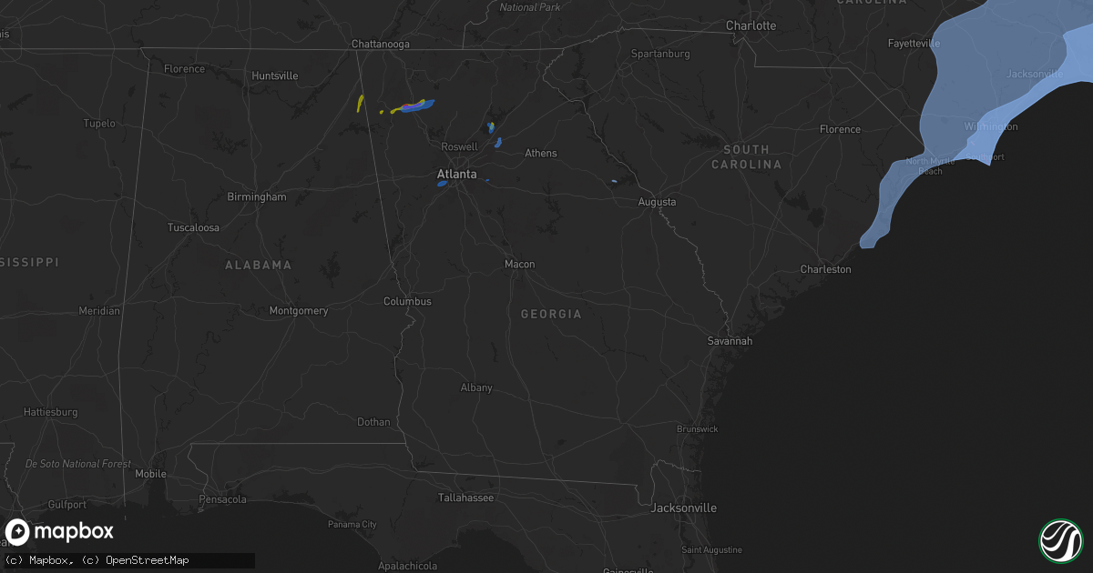
Hail Map in Georgia on August 3, 2020
Get this storm
August 3 map
$229
one time, instant access
Download today. No call, no setup
Keep the $229
Bought the map and want the full workflow? Apply the entire $229 to a subscription within 7 days. None of it is wasted.
Every map, not just this one
This buys you this map. Subscription and you get every map we run, in the markets you choose from a few cities to whole states to nationwide. Plus real-time alerts the moment a storm fires.
Contact data
Name, contact info, occupancy, even credit band for addresses in the footprint. You go from where it hit to who to call.
Become the source they trust
Unlimited branding weather history reports on demand. You already have the documented answer ready for the property owner, and you are the one who showed up with it.
Property data and RoofTrace estimates
Pull up any address you have got, its value and the exact code rules for that jurisdiction, straight from One Click Code. Then RoofTrace estimates the squares, pitch, and roof value, priced the way you price.
Storm reports in Georgia
Georgia
| Date | Description |
|---|---|
| 08/03/20205:34 PM CDT | Trees down on highway 43 at amity woodlawn rd. |
| 08/03/20205:17 PM CDT | Tree down in the city of dublin near intersection of vine st and hudson st. |
| 08/03/20205:07 PM CDT | Tree down along bailey road. |
| 08/03/20205:05 PM CDT | Tree down along ware mclendon road. |
| 08/03/20205:02 PM CDT | Tree down near the intersection of newton road and pecan grove road. |
| 08/03/20205:01 PM CDT | Tree down along jones chapel road. |
| 08/03/20205:00 PM CDT | Tree down along hill street in the city of washington. |
| 08/03/20203:28 PM CDT | Several trees down along high shoals road. |
| 08/03/20203:28 PM CDT | Several trees down along the 2300 block of high shoals road. |
| 08/03/20203:15 PM CDT | Large tree down along grant road. |
| 08/03/20203:15 PM CDT | Large tree down on house along yates drive. |
| 08/03/20203:15 PM CDT | Tree down on powerline along yancy street. |
| 08/03/20203:05 PM CDT | Two trees were downed in the 2100 block of rays church road. |
| 08/03/20203:05 PM CDT | Numerous trees were snapped or uprooted in the 2000 block of rays church road. |
| 08/03/20202:50 PM CDT | Trees reported down on powerlines along hwy 36... North of barnesville. Time estimated from radar. |
| 08/03/20202:47 PM CDT | Tree down near the intersection of michael rd and ike stone rd. |
| 08/03/20202:34 PM CDT | Tree down near intersection of mt. Parin church rd and hwy 11. |
| 08/03/20202:31 PM CDT | Tree down near intersection of monroe jersey rd and criswell rd. |
| 08/03/20202:30 PM CDT | 60+ trees reported down across mainly the western... Central... And northern portions of walton county per emergency management officials. |
| 08/03/20202:27 PM CDT | Tree reported down along fannie thompson road. |
| 08/03/20202:21 PM CDT | Tree down along stock gap rd. |
| 08/03/20202:07 PM CDT | Trees downed on s hicks circle in conyers and along honey creek road. |
| 08/03/20202:05 PM CDT | Metal roofing ripped from the strip mall at the intersection of hwy 53 east and hwy 400. Metal was blown into large power lines behind the building and severed the line |
| 08/03/20202:01 PM CDT | Tree down in the 2000 block of gum creek church rd. |
| 08/03/20202:01 PM CDT | Tree down on power lines. |
| 08/03/20201:58 PM CDT | Several trees reported down near the intersection of center hill church road and south sharon church rd. |
| 08/03/20201:52 PM CDT | Tree downed onto the road at spalding drive and old dominion drive |
| 08/03/20201:50 PM CDT | Tree blocking all lanes at cannady court and treadwick drive. |
| 08/03/20201:45 PM CDT | Tree down on powerlines along kayron drive and reed lane causing road closure. |
| 08/03/20201:42 PM CDT | Tree downed onto a bath house off of vanns tavern rd near vanns tavern park. |
| 08/03/20201:42 PM CDT | Tree downed over the road on donaldson drive near blairsville circle |
| 08/03/20201:40 PM CDT | Quarter-sized hail reported in oscarville on hwy 369... 1.25 miles from the lake lanier bridge. |
| 08/03/20201:40 PM CDT | Boat dock turned loose... Boat dock forced on top of another boat dock... Numerous trees down... And quarter-sized hail reported on/near the 9000 block of ponderosa tra |
| 08/03/20201:39 PM CDT | Numerous trees down along mcswain dr... Old mill dr... And bailey mill road near lake lanier. |
| 08/03/20201:30 PM CDT | Metal awning above boats sustained damage at the aqualand marina. |
| 08/03/20201:15 PM CDT | Trees and power lines down along wolf fork road. |
| 08/03/20201:15 PM CDT | A few trees and power lines downed on antioch church rd. |
| 08/03/20201:10 PM CDT | A few trees and power lines downed on tilley rd. |
| 08/03/20201:10 PM CDT | Several trees downed in south fulton. Old fairburn road and lakeside blvd. |
| 08/03/20201:10 PM CDT | Trees were downed in the deerwood academy area on fairburn rd sw. |
| 08/03/20201:10 PM CDT | 7-10 trees taken down near intersection of hwy 136 and old post trail. |
| 08/03/20201:09 PM CDT | Upwards of 25 trees reported down across the northwestern portion of pickens county. |
| 08/03/202012:40 PM CDT | Tennis ball-sized hail reported on fairmount highway near cash road. |
| 08/03/202012:38 PM CDT | Tennis ball-sized hail reported at sonora drive se... Leaving dents in cars. |
| 08/03/202012:30 PM CDT | Multiple trees down along charmin circle road. |
| 08/03/202012:30 PM CDT | Trees reported snapped/uprooted between hwy 124 and hog mountain rd. |
| 08/03/202012:27 PM CDT | A couple trees downed and roof damage to a structure on hensley rd se |
| 08/03/202012:22 PM CDT | Roof damage to several homes along bowdoin lane... Including shingles and insulation pulled off |
| 08/03/202012:16 PM CDT | Quarter- to half dollar-sized hail reported near the intersection of plainville rd and old calhoun rd. |
| 08/03/202011:12 AM CDT | Quarter-sized hail reported along the al/ga line. |
| 08/03/20207:20 AM CDT | At 1220 PM EDT, a severe thunderstorm was located near Tidings, or 8 miles southeast of Summerville, moving northeast at 25 mph. HAZARD...60 mph wind gusts and quarter size hail. SOURCE...Radar indicated. IMPACT...Hail damage to vehicles is expected. Expect wind damage to roofs, siding, and trees. Locations impacted include... Rome, Calhoun, Plainville, Shannon, Lyerly, Pinson, Oostanaula, Tidings, Armuchee, Lake Marvin, Coosa, Sugar Valley, Everett Springs, James H. Floyd State Park and Holland. |
| 08/03/20206:13 AM CDT | At 1113 AM CDT, a severe thunderstorm was located 8 miles northeast of Little River Falls, or 10 miles northeast of Little River Canyon National Preserve, moving north at 20 mph. HAZARD...Quarter size hail. SOURCE...Radar indicated. IMPACT...Damage to vehicles is expected. This severe thunderstorm will remain over mainly rural areas of east central DeKalb County. |
| 08/02/202010:39 PM CDT | At 339 PM EDT, a severe thunderstorm was located over Monroe, moving east at 15 mph. HAZARD...60 mph wind gusts and quarter size hail. SOURCE...Radar indicated. IMPACT...Hail damage to vehicles is expected. Expect wind damage to roofs, siding, and trees. Locations impacted include... Monroe, Social Circle, Bostwick, Between, Good Hope, Jersey, Herndonville, Ebenezer, Gratis, Nicholasville, Pannell and Campton. |
| 08/02/20209:48 PM CDT | At 248 PM EDT, a severe thunderstorm was located over Big Haynes Creek Park, or near Conyers, moving east at 10 mph. HAZARD...60 mph wind gusts and half dollar size hail. SOURCE...Radar indicated. IMPACT...Hail damage to vehicles is expected. Expect wind damage to roofs, siding, and trees. Locations impacted include... Conyers, Monroe, Snellville, Loganville, Dacula, Grayson, Walnut Grove, Between, Jersey, Lakeview Estates, Bold Springs, Windsor, Harbin, Nicholasville, Milstead, Youth, Big Haynes Creek Park, Pannell and Rosebud. |
| 08/02/20209:41 PM CDT | At 241 PM EDT, a severe thunderstorm was located over Oscarville, or 7 miles west of Gainesville, moving north at 15 mph. HAZARD...60 mph wind gusts and quarter size hail. SOURCE...Radar indicated. IMPACT...Hail damage to vehicles is expected. Expect wind damage to roofs, siding, and trees. Locations impacted include... Gainesville, Dawsonville, Oakwood, Dougherty, Silver City, Chestatee, Murrayville, Oscarville, Coal Mountain and War Hill Park. |
| 08/02/20209:10 PM CDT | At 209 PM EDT, a severe thunderstorm was located over Rest Haven, or 10 miles southeast of Cumming, moving northwest at 10 mph. HAZARD...60 mph wind gusts and half dollar size hail. SOURCE...Radar indicated. IMPACT...Hail damage to vehicles is expected. Expect wind damage to roofs, siding, and trees. Locations impacted include... Gainesville, Sugar Hill, Suwanee, Buford, Flowery Branch, Oakwood, Rest Haven, Buford Dam-Lake Lanier Parks, Aqualand Park, Chestatee, Chestnut Mountain, Oscarville, Lake Lanier Islands and Hog Mountain. |
| 08/02/20209:01 PM CDT | At 201 PM EDT, a severe thunderstorm was located near Campbellton, or 12 miles southeast of Douglasville, moving northeast at 15 mph. HAZARD...60 mph wind gusts and quarter size hail. SOURCE...Radar indicated. IMPACT...Hail damage to vehicles is expected. Expect wind damage to roofs, siding, and trees. Locations impacted include... Atlanta, Douglasville, East Point, Union City, Fairburn, Austell, Palmetto, Lithia Springs, Chattahoochee Hills, Sweetwater Creek State Park, Chapel Hill, Six Flags Over Georgia, Cascade Heights, Campbellton, Sandtown and Mableton. |
| 08/02/20208:54 PM CDT | At 152 PM EDT, a severe thunderstorm was located over Ranger, or 12 miles east of Calhoun, moving northeast at 25 mph. HAZARD...Golf ball size hail and 60 mph wind gusts. SOURCE...Radar indicated. At 145 PM EDT, public reported tennis ball-sized hail on Fairmount Highway in Gordon County. IMPACT...People and animals outdoors will be injured. Expect hail damage to roofs, siding, windows, and vehicles. Expect wind damage to roofs, siding, and trees. Locations impacted include... Ellijay, East Ellijay, Talking Rock, Fairmount, Ranger, Talona, Blaine, Oakman, Hinton and Roundtop. |
| 08/02/20208:20 PM CDT | At 120 PM EDT, a severe thunderstorm was located near Plainville, or near Calhoun, moving east at 25 mph. HAZARD...60 mph wind gusts and quarter size hail. SOURCE...Radar indicated. IMPACT...Hail damage to vehicles is expected. Expect wind damage to roofs, siding, and trees. Locations impacted include... Calhoun, Adairsville, Resaca, Plainville, Fairmount, Ranger, Sonoraville, Oostanaula, Redbud, Folsom, Nickelsville and Audubon. |
All States Impacted by Hail Map on August 3, 2020
Cities Impacted by Hail Map on August 3, 2020
- Fredericksburg, VA
- La Veta, CO
- Weston, CO
- Fort Garland, CO
- Elizabeth, CO
- Kiowa, CO
- Parker, CO
- Raton, NM
- Branson, CO
- Trinchera, CO
- Springfield, CO
- Pritchett, CO
- Gaylesville, AL
- Mentone, AL
- Centre, AL
- Cedar Bluff, AL
- Rome, GA
- Anniston, AL
- Fairmount, GA
- Plainville, GA
- Armuchee, GA
- Adairsville, GA
- Calhoun, GA
- Rydal, GA
- Gainesville, GA
- Flowery Branch, GA
- Kaycee, WY
- Bosler, WY
- Wheatland, WY
- Belle Haven, VA
- Salisbury, MD
- Rose Hill, NC
- Powells Point, NC
- Ahoskie, NC
- Hallieford, VA
- Point Harbor, NC
- Grandy, NC
- Elizabeth City, NC
- Solomons, MD
- Kure Beach, NC
- Maple Hill, NC
- Rich Square, NC
- Horntown, VA
- Cobbs Creek, VA
- Bolton, NC
- Fayetteville, NC
- Avenue, MD
- Oak City, NC
- Wallops Island, VA
- Willards, MD
- Onemo, VA
- Federalsburg, MD
- Abell, MD
- Trappe, MD
- Linkwood, MD
- Columbia, NC
- Kilmarnock, VA
- New Church, VA
- Edward, NC
- Carrollton, VA
- Hubert, NC
- Seven Springs, NC
- Nags Head, NC
- King And Queen Court House, VA
- Wake, VA
- Bethel, DE
- Gibson Island, MD
- Albertson, NC
- Melfa, VA
- Grantsboro, NC
- Kinsale, VA
- Fremont, NC
- Eden, MD
- Council, NC
- Plymouth, NC
- Gatesville, NC
- Hebron, MD
- North Beach, MD
- Wilmington, NC
- Callao, VA
- Teachey, NC
- Moyock, NC
- Easton, MD
- Claiborne, MD
- Fruitland, MD
- Creswell, NC
- Salemburg, NC
- Virginia Beach, VA
- Montross, VA
- Scotland, MD
- Great Mills, MD
- Winnabow, NC
- Chester, MD
- Marshallberg, NC
- Windsor, NC
- North, VA
- Bladenboro, NC
- Deep Run, NC
- Chinquapin, NC
- Pollocksville, NC
- Tall Timbers, MD
- Stedman, NC
- Surry, VA
- Bolivia, NC
- Moon, VA
- Atlantic, NC
- Mattaponi, VA
- Deale, MD
- Pawleys Island, SC
- Broomes Island, MD
- Wittman, MD
- Ocean Isle Beach, NC
- Burgess, VA
- Lusby, MD
- Bethel, NC
- Deltaville, VA
- Laurel, DE
- Frisco, NC
- Dudley, NC
- Harkers Island, NC
- Manteo, NC
- Avon, NC
- Hollywood, MD
- Oriental, NC
- Delmar, MD
- Churchton, MD
- Owings, MD
- Center Cross, VA
- Deal Island, MD
- Seaford, DE
- Lake Waccamaw, NC
- Delmar, DE
- Galesville, MD
- Royal Oak, MD
- Aylett, VA
- Garland, NC
- Maple, NC
- Painter, VA
- Longwood, NC
- Warwick, MD
- Hurlock, MD
- Ayden, NC
- Arapahoe, NC
- Hallwood, VA
- West Point, VA
- Nanticoke, MD
- Willard, NC
- Saint Michaels, MD
- Hartfield, VA
- New Kent, VA
- Hamilton, NC
- Oxford, MD
- Shacklefords, VA
- Foster, VA
- Farmville, NC
- Kitty Hawk, NC
- Jacksonville, NC
- Gloucester Point, VA
- Murfreesboro, NC
- Gunpowder, MD
- Ernul, NC
- Grimesland, NC
- Tracys Landing, MD
- Williamsburg, VA
- Poplar Branch, NC
- Valley Lee, MD
- Snow Hill, NC
- Riegelwood, NC
- Drayden, MD
- South Mills, NC
- Colerain, NC
- Merry Hill, NC
- Gates, NC
- Hatteras, NC
- Queenstown, MD
- Kenansville, NC
- Lanexa, VA
- Dameron, MD
- Lexington Park, MD
- Bloxom, VA
- Hayes, VA
- Dunnsville, VA
- Merritt, NC
- Belhaven, NC
- Hampstead, NC
- Prince Frederick, MD
- Harrellsville, NC
- La Grange, NC
- Onley, VA
- Jamesville, NC
- Salvo, NC
- Georgetown, SC
- Dover, NC
- Conway, SC
- Atlantic, VA
- Atlantic Beach, NC
- Tyner, NC
- Hookerton, NC
- Barco, NC
- Whiteville, NC
- Aberdeen Proving Ground, MD
- Hobbsville, NC
- Rhodesdale, MD
- Roper, NC
- Girdletree, MD
- Hacksneck, VA
- Murrells Inlet, SC
- Still Pond, MD
- King William, VA
- Delco, NC
- Selbyville, DE
- Quantico, MD
- Stokes, NC
- Bath, NC
- Colonial Beach, VA
- Laneview, VA
- Vanceboro, NC
- Wingate, MD
- Frankford, DE
- Carolina Beach, NC
- Newton Grove, NC
- Princess Anne, MD
- Southport, NC
- Beaufort, NC
- Oak Island, NC
- Gloucester, VA
- Cambridge, MD
- Davis, NC
- Farnham, VA
- Champlain, VA
- Smithfield, VA
- Carrsville, VA
- Engelhard, NC
- Shady Side, MD
- Corolla, NC
- Tangier, VA
- Pinetops, NC
- Mcdaniel, MD
- Preston, MD
- Stacy, NC
- Lewiston Woodville, NC
- Stantonsburg, NC
- Bayboro, NC
- Withams, VA
- Suffolk, VA
- Scranton, NC
- North East, MD
- Turkey, NC
- Chestertown, MD
- Betterton, MD
- Mears, VA
- Tilghman, MD
- Burgaw, NC
- Chesapeake City, MD
- Saint Inigoes, MD
- Lancaster, VA
- Yorktown, VA
- Washington, NC
- Midway Park, NC
- Cardinal, VA
- Dutton, VA
- Parksley, VA
- Port Haywood, VA
- Windsor, VA
- Winton, NC
- Wanchese, NC
- Norfolk, VA
- Fairfield, NC
- Roxobel, NC
- Emerald Isle, NC
- Gwynn, VA
- Wallace, NC
- Saluda, VA
- Chesapeake, VA
- Fort Monroe, VA
- Mardela Springs, MD
- Tappahannock, VA
- Crisfield, MD
- Stella, NC
- Greenbush, VA
- North Myrtle Beach, SC
- Mount Olive, NC
- Stevensville, MD
- Callaway, MD
- Warsaw, NC
- Showell, MD
- Clements, MD
- Toddville, MD
- Pinetown, NC
- Rock Hall, MD
- Benson, NC
- East New Market, MD
- Sanford, VA
- Cedar Island, NC
- Mascot, VA
- Macclesfield, NC
- Eure, NC
- Four Oaks, NC
- California, MD
- Centreville, MD
- Shiloh, NC
- Neavitt, MD
- Stockton, MD
- Fishing Creek, MD
- Water View, VA
- Newsoms, VA
- Weems, VA
- Smyrna, NC
- Bivalve, MD
- Nakina, NC
- Urbanna, VA
- Waves, NC
- Princeton, NC
- Sherwood, MD
- Rodanthe, NC
- Woodland, NC
- Ridge, MD
- Ewell, MD
- Worton, MD
- Walkerton, VA
- Temperanceville, VA
- Bozman, MD
- Maysville, NC
- Franklin, VA
- Assawoman, VA
- Coltons Point, MD
- Park Hall, MD
- Millsboro, DE
- Edgewater, MD
- Sealevel, NC
- Goldsboro, NC
- Stumpy Point, NC
- Swanquarter, NC
- Pasadena, MD
- Hertford, NC
- Vienna, MD
- Reedville, VA
- Little River, SC
- Autryville, NC
- Topping, VA
- Greenbackville, VA
- Faison, NC
- Barhamsville, VA
- Salter Path, NC
- Magnolia, NC
- Camden, NC
- White Stone, VA
- Church Creek, MD
- Clarendon, NC
- Hobucken, NC
- Loris, SC
- Sneads Ferry, NC
- Quinby, VA
- Edenton, NC
- Parsonsburg, MD
- Accomac, VA
- Taylors Island, MD
- Robersonville, NC
- Holly Ridge, NC
- Sunset Beach, NC
- Clinton, NC
- Bruington, VA
- Ash, NC
- Stevensville, VA
- Sunderland, MD
- Secretary, MD
- Harrells, NC
- Church View, VA
- Sparrows Point, MD
- Marion Station, MD
- Buxton, NC
- Ocean City, MD
- Elberon, VA
- Atkinson, NC
- Elkton, MD
- Corapeake, NC
- Mechanicsville, MD
- Piney Point, MD
- Lowland, NC
- Vandemere, NC
- Harbinger, NC
- Nassawadox, VA
- Wilson, NC
- Lottsburg, VA
- Mathews, VA
- Beulaville, NC
- McClellanville, SC
- Saint Stephens Church, VA
- Dowell, MD
- West River, MD
- Kelly, NC
- Cove City, NC
- Swansboro, NC
- Grifton, NC
- Little Plymouth, VA
- Warsaw, VA
- Currituck, NC
- Conway, NC
- Franktown, VA
- Chincoteague Island, VA
- Chocowinity, NC
- Irvington, VA
- Newport News, VA
- Whaleyville, MD
- Castle Hayne, NC
- Annapolis, MD
- Kennedyville, MD
- Coinjock, NC
- Longs, SC
- Leland, NC
- Myrtle Beach, SC
- Greenville, NC
- Como, NC
- Westover, MD
- Supply, NC
- Hardyville, VA
- Ocracoke, NC
- Chadbourn, NC
- Hobgood, NC
- Camp Lejeune, NC
- Birdsnest, VA
- Shawboro, NC
- Madison, MD
- Pink Hill, NC
- Winterville, NC
- Earleville, MD
- Fountain, NC
- Tyaskin, MD
- New Bern, NC
- Walstonburg, NC
- Pittsville, MD
- Manns Harbor, NC
- Currie, NC
- Cape Charles, VA
- Belvidere, NC
- Kill Devil Hills, NC
- Tarawa Terrace, NC
- Perryville, MD
- Aulander, NC
- Woolford, MD
- Kelford, NC
- Pikeville, NC
- Crapo, MD
- Hemingway, SC
- Cofield, NC
- Jarvisburg, NC
- Saint Leonard, MD
- Toano, VA
- Newport, NC
- Sharptown, MD
- Sunbury, NC
- Portsmouth, VA
- Exmore, VA
- Loveville, MD
- Tabor City, NC
- Calypso, NC
- Chesapeake Beach, MD
- Tarboro, NC
- Arnold, MD
- Morehead City, NC
- Knotts Island, NC
- Aydlett, NC
- Williamston, NC
- Seaford, VA
- Diggs, VA
- Blounts Creek, NC
- Grasonville, MD
- Wrightsville Beach, NC
- Port Republic, MD
- Calabash, NC
- Trenton, NC
- Aurora, NC
- Crocheron, MD
- Bohannon, VA
- Clarkton, NC
- Elizabethtown, NC
- Fort Eustis, VA
- Patuxent River, MD
- Hague, VA
- Pantego, NC
- Oak Hall, VA
- Richlands, NC
- Leonardtown, MD
- Shallotte, NC
- Dunn, NC
- Berlin, MD
- Scotland Neck, NC
- Snow Hill, MD
- Jamaica, VA
- Ivanhoe, NC
- Heathsville, VA
- Havelock, NC
- Machipongo, VA
- Locust Hill, VA
- Kinston, NC
- Newark, MD
- Hallsboro, NC
- Elm City, NC
- Huntingtown, MD
- Onancock, VA
- Susan, VA
- Friendship, MD
- Roseboro, NC
- Harwood, MD
- Rocky Point, NC
- Bishopville, MD
- Godwin, NC
- Gloucester, NC
- Poquoson, VA
- Hudgins, VA
- Hampton, VA
- Pocomoke City, MD
- Greenwich, NJ
- Bridgeton, NJ
- Millville, NJ
- Cedarville, NJ
- Newport, NJ
- Port Norris, NJ
- Woodbury, NY
- Hazlet, NJ
- Lawrence, NY
- New Haven, CT
- Irvington, NJ
- Roosevelt, NY
- Nutley, NJ
- Huntington Station, NY
- Teterboro, NJ
- Carteret, NJ
- Sewaren, NJ
- Red Bank, NJ
- Merrick, NY
- Richmond Hill, NY
- Hastings On Hudson, NY
- Maywood, NJ
- Queens Village, NY
- Port Washington, NY
- South Ozone Park, NY
- Pelham, NY
- Bogota, NJ
- South Amboy, NJ
- Fairfield, CT
- Closter, NJ
- Bronx, NY
- Bayonne, NJ
- Inwood, NY
- Greenvale, NY
- Newark, NJ
- College Point, NY
- Holmdel, NJ
- Hewlett, NY
- Port Chester, NY
- Lynbrook, NY
- Mill Neck, NY
- Middle Village, NY
- Manhasset, NY
- Union, NJ
- Ridgewood, NY
- Leonia, NJ
- Roselle, NJ
- Elmont, NY
- North Bergen, NJ
- Jersey City, NJ
- Saint Albans, NY
- White Plains, NY
- Ridgefield Park, NJ
- Carlstadt, NJ
- Woodmere, NY
- New Milford, NJ
- Cambria Heights, NY
- Bayville, NY
- East Rutherford, NJ
- Rockville Centre, NY
- Weehawken, NJ
- Staten Island, NY
- Roselle Park, NJ
- Hasbrouck Heights, NJ
- Purchase, NY
- Wood Ridge, NJ
- Kew Gardens, NY
- Glen Head, NY
- East Rockaway, NY
- Oceanside, NY
- Rutherford, NJ
- Bayside, NY
- Hackensack, NJ
- Hoboken, NJ
- Hillside, NJ
- Westport, CT
- Rumson, NJ
- Bellmore, NY
- Edgewater, NJ
- Breezy Point, NY
- Clifton, NJ
- Rahway, NJ
- Sea Cliff, NY
- Fort Lee, NJ
- Atlantic Highlands, NJ
- Perth Amboy, NJ
- Harrison, NJ
- Westbury, NY
- Malverne, NY
- Maspeth, NY
- Massapequa, NY
- Port Monmouth, NJ
- Haworth, NJ
- Parlin, NJ
- Melville, NY
- Fairview, NJ
- Point Lookout, NY
- Cresskill, NJ
- Demarest, NJ
- Trumbull, CT
- East Norwich, NY
- Hicksville, NY
- Lyndhurst, NJ
- East Haven, CT
- River Edge, NJ
- Elmhurst, NY
- Whitestone, NY
- East Elmhurst, NY
- Hollis, NY
- Eastchester, NY
- Long Beach, NY
- Port Reading, NJ
- Norwalk, CT
- Far Rockaway, NY
- Garden City, NY
- Oyster Bay, NY
- Jamaica, NY
- Glen Cove, NY
- East Meadow, NY
- Tuckahoe, NY
- Middletown, NJ
- Harrison, NY
- Cedarhurst, NY
- Greenwich, CT
- Larchmont, NY
- Sunnyside, NY
- Belford, NJ
- Wantagh, NY
- Williston Park, NY
- Teaneck, NJ
- Floral Park, NY
- New Hyde Park, NY
- Babylon, NY
- Moonachie, NJ
- Elizabeth, NJ
- Albertson, NY
- Bellerose, NY
- Elizabethport, NJ
- Woodside, NY
- Scarsdale, NY
- Arverne, NY
- Carle Place, NY
- Alpine, NJ
- Cos Cob, CT
- South Richmond Hill, NY
- Franklin Square, NY
- Matawan, NJ
- Highlands, NJ
- Rockaway Park, NY
- Sayreville, NJ
- Long Island City, NY
- Tenafly, NJ
- Rosedale, NY
- Springfield Gardens, NY
- Glen Oaks, NY
- Edison, NJ
- Cold Spring Harbor, NY
- Brooklyn, NY
- Massapequa Park, NY
- Amityville, NY
- Mineola, NY
- Southport, CT
- Milford, CT
- Mount Vernon, NY
- New York, NY
- Stratford, CT
- Keyport, NJ
- Oakland Gardens, NY
- Ridgefield, NJ
- Bridgeport, CT
- Roslyn, NY
- Forest Hills, NY
- Old Westbury, NY
- Huntington, NY
- Rye, NY
- Palisades Park, NJ
- Darien, CT
- Ozone Park, NY
- Island Park, NY
- Jericho, NY
- South Hackensack, NJ
- Howard Beach, NY
- Avenel, NJ
- Astoria, NY
- Fresh Meadows, NY
- West Hempstead, NY
- Roslyn Heights, NY
- Jackson Heights, NY
- Woodhaven, NY
- Lodi, NJ
- New Rochelle, NY
- Colonia, NJ
- Freeport, NY
- Flushing, NY
- Metuchen, NJ
- Uniondale, NY
- Mamaroneck, NY
- Little Ferry, NJ
- Secaucus, NJ
- Iselin, NJ
- Englewood, NJ
- Little Neck, NY
- Great Neck, NY
- Seaford, NY
- Wallington, NJ
- Bergenfield, NJ
- Norwood, NJ
- Baldwin, NY
- Plainview, NY
- Dumont, NJ
- Englewood Cliffs, NJ
- East Orange, NJ
- Orange, CT
- Yonkers, NY
- West Harrison, NY
- Locust Valley, NY
- Bronxville, NY
- Old Bethpage, NY
- Atlantic Beach, NY
- Kearny, NJ
- Glenwood Landing, NY
- Cliffside Park, NJ
- Syosset, NY
- Corona, NY
- Stamford, CT
- Union City, NJ
- New Canaan, CT
- North Arlington, NJ
- Valley Stream, NY
- Belleville, NJ
- Bloomfield, NJ
- Farmingdale, NY
- Keasbey, NJ
- Linden, NJ
- Keansburg, NJ
- Cliffwood, NJ
- Fords, NJ
- Rego Park, NY
- Clark, NJ
- Levittown, NY
- Leonardo, NJ
- Old Greenwich, CT
- Hempstead, NY
- West New York, NJ
- West Haven, CT
- Bethpage, NY
- Riverside, CT
- Woodbridge, NJ
- West Hartford, CT
- Portland, CT
- Hartford, CT
- Wethersfield, CT
- Rocky Hill, CT
- Higganum, CT
- Newington, CT
- Cromwell, CT
- Bloomfield, CT
- Windsor, CT
- Middletown, CT
- Princeton Junction, NJ
- Monroe Township, NJ
- Hightstown, NJ
- Bridgewater, NJ
- Hillsborough, NJ
- Neshanic Station, NJ
- Somerville, NJ
- Peapack, NJ
- Bedminster, NJ
- Far Hills, NJ
- Basking Ridge, NJ
- Chester, NJ
- Boonton, NJ
- Pine Brook, NJ
- Lake Hiawatha, NJ
- Montville, NJ
- Parsippany, NJ
- East Hanover, NJ
- Towaco, NJ
- Centerport, NY
- Greenlawn, NY
- East Northport, NY
- Northport, NY
- Commack, NY
- Hopewell Junction, NY
- Lagrangeville, NY
- Poughquag, NY
- Holmes, NY
- Stormville, NY
- Patterson, NY
- Brewster, NY
- Carmel, NY
- Middlebury, CT
- Oxford, CT
- Woodbury, CT
- Southbury, CT
- Naugatuck, CT
- Watertown, CT
- Waterbury, CT
- Oakville, CT
- Bristol, CT
- Harwinton, CT
- New Hartford, CT
- Burlington, CT
- Winsted, CT
- Torrington, CT
- East Hartford, CT
- South Windsor, CT
- East Windsor, CT
- West Suffield, CT
- Southwick, MA
- Enfield, CT
- Windsor Locks, CT
- East Granby, CT
- Manchester, CT
- Feeding Hills, MA
- Suffield, CT
- Broad Brook, CT
- Westfield, MA
- Huntington, MA
- Russell, MA
- Chester, MA
- Worthington, MA
- Granby, MA
- South Hadley, MA
- Amherst, MA
- Belchertown, MA
- Hadley, MA
- Marlborough, CT
- Glastonbury, CT
- Hebron, CT
- Andover, CT
- Lebanon, CT
- Columbia, CT
- Bolton, CT
- Colchester, CT
- Amston, CT
- Coventry, CT
- Blandford, MA
- Holyoke, MA
- Chicopee, MA
- Agawam, MA
- Springfield, MA
- West Springfield, MA
- Courtland, VA
- Bear, DE
- Odessa, DE
- Middletown, DE
- Townsend, DE
- Dover, DE
- Smyrna, DE
- Gravel Switch, KY
- Harrodsburg, KY
- Perryville, KY
- Danville, KY
- Junction City, KY
- Parksville, KY
- Livingston, MT
- Columbus, MT
- Molt, MT
- Park City, MT
- Laurel, MT
- Billings, MT
- Rainsville, NM
- Buena Vista, NM
- Ocate, NM
- Sapello, NM
- Moriarty, NM
- Ribera, NM
- Cimarron, NM
- Las Vegas, NM
- Serafina, NM
- San Jose, NM
- Albuquerque, NM
- Tijeras, NM
- Edgewood, NM
- Corrales, NM
- Gallatin Gateway, MT
- Lewistown, MT
- Manhattan, MT
- Bozeman, MT
- Ranger, GA
- Atlanta, GA
- Fairburn, GA
- Dacula, GA
- Hoschton, GA
- Buford, GA
- Auburn, GA
- Conyers, GA
- Lincolnton, GA
- Chatsworth, NJ
- Vincentown, NJ
- Toms River, NJ
- Point Pleasant Beach, NJ
- Bayville, NJ
- Manasquan, NJ
- Deal, NJ
- Ocean Grove, NJ
- Manchester Township, NJ
- Avon By The Sea, NJ
- Asbury Park, NJ
- Allenhurst, NJ
- Lavallette, NJ
- Sea Girt, NJ
- Allenwood, NJ
- Long Branch, NJ
- Lakewood, NJ
- Belmar, NJ
- Brick, NJ
- Neptune, NJ
- Monmouth Beach, NJ
- Bradley Beach, NJ
- Oceanport, NJ
- Spring Lake, NJ
- Mantoloking, NJ
- Forked River, NJ
- Farmingdale, NJ
- Beachwood, NJ
- West Long Branch, NJ
- Oakhurst, NJ
- Howell, NJ
- Brielle, NJ
- Big Timber, MT
- Floweree, MT
- Great Falls, MT
- Buffalo, WY
- Aguilar, CO
- Moscow, KS
- Lance Creek, WY
- Lead, SD
- Spearfish, SD
- Kim, CO
- Custer, SD
- Belle Fourche, SD
- Bad Axe, MI
- Fort Benton, MT
- Embudo, NM
- Hernandez, NM
- Dawsonville, GA
- Mora, NM
- White, GA
- Cumming, GA
- Cleveland, NM
- Resaca, GA
- Chatsworth, GA


