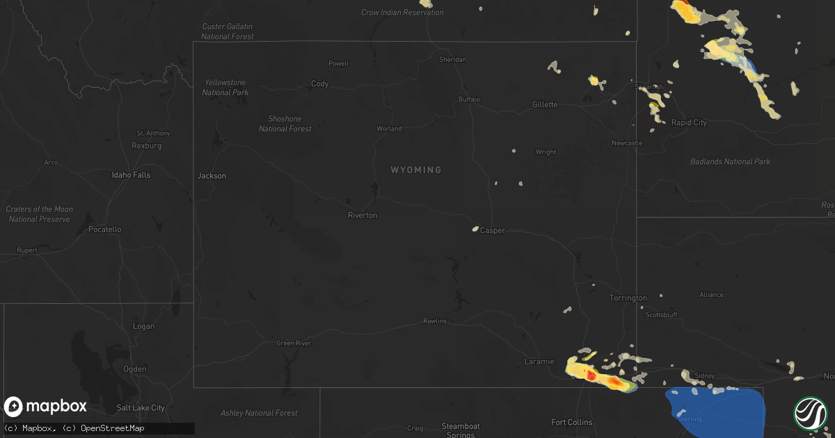
Hail Map in Wyoming on August 1, 2025
Get this storm
August 1 map
$229
one time, instant access
Download today. No call, no setup
Keep the $229
Bought the map and want the full workflow? Apply the entire $229 to a subscription within 7 days. None of it is wasted.
Every map, not just this one
This buys you this map. Subscription and you get every map we run, in the markets you choose from a few cities to whole states to nationwide. Plus real-time alerts the moment a storm fires.
Contact data
Name, contact info, occupancy, even credit band for addresses in the footprint. You go from where it hit to who to call.
Become the source they trust
Unlimited branding weather history reports on demand. You already have the documented answer ready for the property owner, and you are the one who showed up with it.
Property data and RoofTrace estimates
Pull up any address you have got, its value and the exact code rules for that jurisdiction, straight from One Click Code. Then RoofTrace estimates the squares, pitch, and roof value, priced the way you price.
Storm reports in Wyoming
Wyoming
| Date | Description |
|---|---|
| 08/01/20256:59 PM CDT | A local report indicates 2.75 inch wind near Cheyenne |
| 08/01/20256:58 PM CDT | Report from mping: ping pong ball |
| 08/01/20256:56 PM CDT | A local report indicates 1.75 inch wind near 2 E Warren Af Base |
| 08/01/20256:55 PM CDT | Report from mping: hen egg |
| 08/01/20256:55 PM CDT | Report from mping: ping pong ball |
| 08/01/20256:52 PM CDT | Report from mping: ping pong ball |
| 08/01/20256:30 PM CDT | A local report indicates 1.25 inch wind near 13 W Cheyenne |
| 08/01/20256:19 PM CDT | A local report indicates 58 MPH wind near 12 SSE Horse Creek |
| 08/01/20256:18 PM CDT | A local report indicates 1.25 inch wind near 18 WNW Cheyenne |
| 08/01/20254:04 PM CDT | Asos station kgey greybull airport. From a strong outflow boundary. |
| 08/01/20254:04 PM CDT | Asos station kgey greybull airport. From a str |
| 08/01/20254:04 PM CDT | Asos station kgey greybull airport. From a strong outflow bo |
| 08/01/20253:08 PM CDT | Asos station kriw riverton airport. Downdraft from weak convection. |
| 07/31/20259:48 PM CDT | A local report indicates 1.50 inch wind near Devils Tower |
| 07/31/20258:04 PM CDT | Trained spotter reported hail sized up to 3 inches via sm with picture evidence. |
| 07/31/20258:04 PM CDT | Trained spotter reported hail sized up to 3 inches via sm wi |
| 07/31/20257:12 PM CDT | Report from mping: hen egg |
| 07/31/20257:12 PM CDT | Report from mping: tennis ball |
| 07/31/20257:03 PM CDT | Report from mping: ping pong ball |
All States Impacted by Hail Map on August 1, 2025
Cities Impacted by Hail Map on August 1, 2025
- Dodson, MT
- Harlem, MT
- Hays, MT
- Lake City, CO
- Dawson, GA
- Parrott, GA
- Henrietta, TX
- Ellenboro, NC
- Casar, NC
- Munford, AL
- Lawndale, NC
- Talladega, AL
- Tobaccoville, NC
- Pfafftown, NC
- Winston Salem, NC
- Rural Hall, NC
- Patrick, SC
- West, MS
- Tow, TX
- Burnet, TX
- Yadkinville, NC
- Lewisville, NC
- Maben, MS
- Lampasas, TX
- Shelby, NC
- Mathiston, MS
- Harmony, NC
- Mocksville, NC
- Eros, LA
- Newnan, GA
- La Jara, CO
- Abbeville, AL
- Loring, MT
- Sharpsburg, GA
- Camp Hill, AL
- Tallassee, AL
- Boncarbo, CO
- Hobson, MT
- Killeen, TX
- Corsicana, TX
- Sanford, CO
- Antonito, CO
- Maiden, NC
- Lincolnton, NC
- Notasulga, AL
- Statesville, NC
- Buffalo, SD
- Stanford, MT
- Capulin, CO
- Briggs, TX
- Kempner, TX
- Trinidad, CO
- Weston, CO
- Kerens, TX
- Troutman, NC
- Conway, SC
- Lubbock, TX
- Hampton, GA
- Griffin, GA
- Brownfield, TX
- Havelock, NC
- Reva, SD
- Mason, TX
- Locust Grove, GA
- Longs, SC
- Mooresville, NC
- Brady, TX
- Wheatland, WY
- Morganton, NC
- Dallas, NC
- Wetmore, CO
- Gastonia, NC
- McAdenville, NC
- Belmont, NC
- Cramerton, NC
- Lowell, NC
- Fleming, GA
- Richmond Hill, GA
- Midway, GA
- Penrose, CO
- Pueblo, CO
- Prairie City, SD
- Sherrills Ford, NC
- Salisbury, NC
- Linwood, NC
- Kellyton, AL
- Alexander City, AL
- Stanley, NC
- Cubero, NM
- Lexington, NC
- Elizabeth, CO
- Elbert, CO
- Franktown, CO
- Big Timber, MT
- Mount Holly, NC
- Groesbeck, TX
- Charlotte, NC
- Columbus, MT
- Lodge Grass, MT
- Bessemer City, NC
- Absarokee, MT
- Newell, SD
- Model, CO
- Moccasin, MT
- Seagraves, TX
- Walsenburg, CO
- Bennett, CO
- Junction, TX
- Zebulon, GA
- Fowler, CO
- Augusta, MT
- Greensboro, GA
- Cheyenne, WY
- Lamesa, TX
- Mud Butte, SD
- Fort Hood, TX
- Guernsey, WY
- Thornton, TX
- Fort Lupton, CO
- Casper, WY
- Eldorado, TX
- Ocate, NM
- Datil, NM
- Bison, SD
- Miami, NM
- Meadow, SD
- Guadalupita, NM
- Albin, WY
- Pine Bluffs, WY
- Burns, WY
- White Plains, GA
- Matheson, CO
- Immokalee, FL
- Clinton, SC
- Sparta, GA
- Belton, TX
- Temple, TX
- Whitmire, SC
- Limon, CO
- Magdalena, NM
- Skipperville, AL
- Ozark, AL
- Hudson, CO
- Orofino, ID
- Glenrock, WY
- Morrill, NE
- Crow Agency, MT
- Saint Xavier, MT
- Mitchell, GA
- Lemmon, SD
- Lodgepole, SD
- Hugo, CO
- Fe Warren Afb, WY
- Buffalo, MT
- Rocky Ford, CO
- Overton, TX
- Kilgore, TX
- Faith, SD
- Shawmut, MT
- Saluda, SC
- Bushnell, NE
- Somes Bar, CA
- Garryowen, MT
- Warthen, GA
- Pachuta, MS
- Harrison, NE
- Troup, TX
- Midwest, WY
- Rosebud, TX
- Wagon Mound, NM
- Reagan, TX
- Lott, TX
- Jacksonville, TX
- Fort Jones, CA
- Grand Saline, TX
- Valmora, NM
- Custer, MT
- Carpenter, WY
- Karval, CO
- Ramah, CO
- Haswell, CO
- Arlington, CO
- Kit Carson, CO
- Dupree, SD
- Moore, MT
- Union Center, SD
- Sand Coulee, MT
- Great Falls, MT
- Trementina, NM
- Saint George, SC
- Grover, CO
- Lewistown, MT
- Las Vegas, NM
- Klamath River, CA
- Hilger, MT
- Gillette, WY
- Mims, FL
- Harleyville, SC
- Henderson, TX
- Hereford, CO
- Eads, CO
- Deadwood, SD
- Rusk, TX
- Pickton, TX
- Lead, SD
- Murchison, TX
- White Owl, SD
- Howes, SD
- Hill City, SD
- Leroy, AL
- Happy Camp, CA
- Cross Plains, TX
- Brownsboro, TX
- McGregor, TX
- Huntington, TX
- Winnsboro, TX
- Saint Stephens, AL
- Bruneau, ID
- Quitman, TX
- Scroggins, TX
- Padroni, CO
- Sterling, CO
- Peetz, CO
- Iliff, CO
- Fleming, CO
- Crook, CO
- Birney, MT
- Pittsburg, TX
- Leesburg, TX
- Gilmer, TX
- Cherry Creek, SD
- Atwood, CO
- Sedgwick, CO
- Haxtun, CO
- Wild Horse, CO
- Grove Hill, AL
- La Junta, CO
- Jackson, AL
- Two Dot, MT
- Weston, WY
- Akron, CO
- Cheyenne Wells, CO
- Sheridan Lake, CO
- Las Animas, CO
- Otis, CO
- Cameron, TX
- Milesville, SD
- Sundance, WY
- Yuma, CO
- Ovid, CO
- Julesburg, CO
- Devils Tower, WY
- Dix, NE
- Potter, NE
- Burkett, TX
- Sidney, NE
- Kimball, NE
- Winnett, MT
- Como, TX
- Cleveland, TN
- Holyoke, CO
- Eckley, CO
- Paoli, CO
- Wray, CO
- Venango, NE
- Amherst, CO
- Colorado City, TX
- Hermleigh, TX
- Geyser, MT
- Vaughn, NM
- Sturgis, SD
- Champion, NE
- Zortman, MT
- Lloyd, MT
- Snyder, TX
- Kim, CO
- Powderly, TX
- Arthur City, TX
- Santa Rosa, NM
- Klondike, TX
- Ogallala, NE
- Beulah, WY
- Raynesford, MT
- Chinook, MT
- Spearfish, SD
- Alzada, MT
- Grand View, ID
- Cumby, TX
- Lemoyne, NE
- Blossom, TX
- Detroit, TX
- Hammond, MT
- Springfield, CO
- Keystone, NE
- Commerce, TX
- Whitewood, SD
- Big Sandy, MT
- Geraldine, MT
- Paris, TX
- Terrell, TX
- Stapleton, NE
- Hugo, OK
- Yeso, NM
- Kaufman, TX
- Wall, SD
- Paxton, NE
- Belle Fourche, SD
- Nemo, SD
- Lincoln, NM
- Hayes Center, NE
- Zavalla, TX
- Ekalaka, MT
- Sulphur Springs, TX
- Brashear, TX
- Palisade, NE
- Newcastle, WY
- Merkel, TX
- Philip, SD
- Culbertson, NE
- Hawley, TX
- Oneill, NE
- Chappell, NE
- North Platte, NE
- Brady, NE
- Loma, MT
- Fort Benton, MT
- Malta, MT
- Billings, MT
- Cuervo, NM


