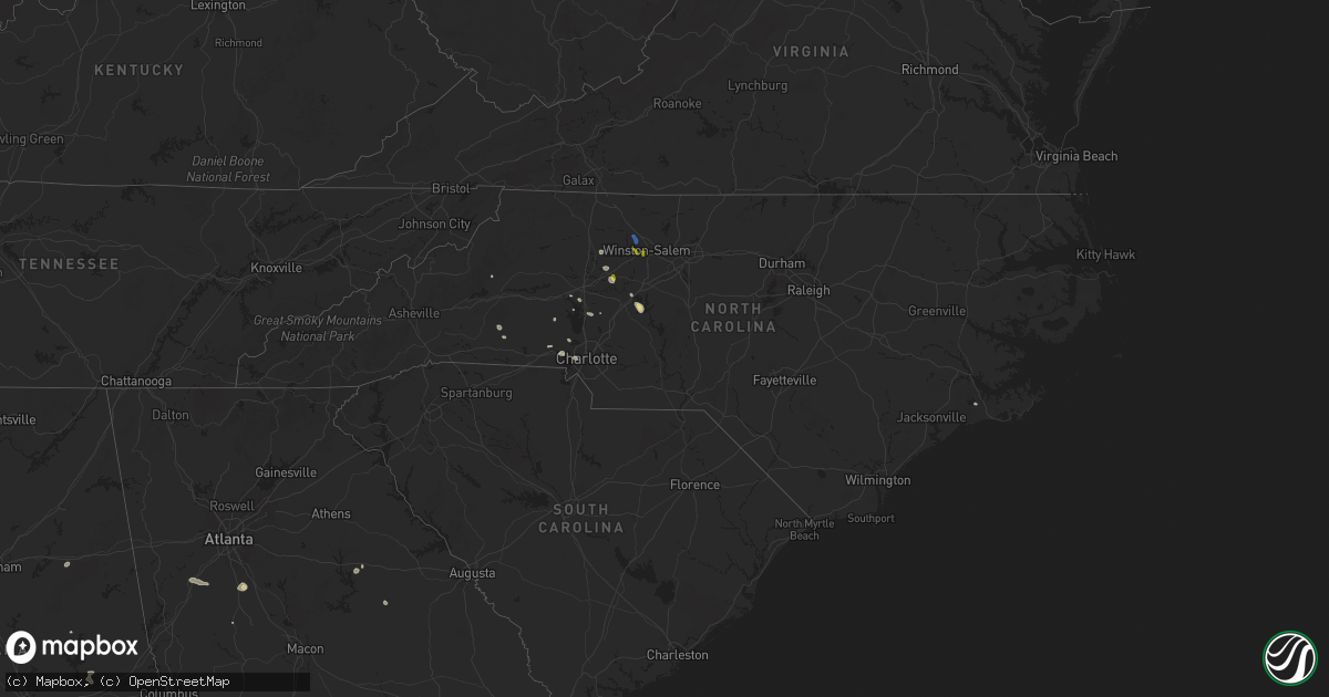
Hail Map in North Carolina on August 1, 2025
Get this storm
August 1 map
$229
one time, instant access
Download today. No call, no setup
Keep the $229
Bought the map and want the full workflow? Apply the entire $229 to a subscription within 7 days. None of it is wasted.
Every map, not just this one
This buys you this map. Subscription and you get every map we run, in the markets you choose from a few cities to whole states to nationwide. Plus real-time alerts the moment a storm fires.
Contact data
Name, contact info, occupancy, even credit band for addresses in the footprint. You go from where it hit to who to call.
Become the source they trust
Unlimited branding weather history reports on demand. You already have the documented answer ready for the property owner, and you are the one who showed up with it.
Property data and RoofTrace estimates
Pull up any address you have got, its value and the exact code rules for that jurisdiction, straight from One Click Code. Then RoofTrace estimates the squares, pitch, and roof value, priced the way you price.
Storm reports in North Carolina
North Carolina
| Date | Description |
|---|---|
| 08/01/20256:12 PM CDT | Fallen trees and power lines. |
| 08/01/20255:30 PM CDT | Trees down on ebenezer church rd on power equipment. |
| 08/01/20255:30 PM CDT | Trees down on ebenezer church |
| 08/01/20255:03 PM CDT | Social media picture of a tree down between mineral springs and wesley chapel. |
| 08/01/20254:58 PM CDT | Tree down across the road. |
| 08/01/20254:37 PM CDT | Social media picture of a tree down on a car near selwyn ave. |
| 08/01/20254:30 PM CDT | Corrects previous tstm wnd dmg report from 3 e mount pleasant. 1501 lentz harness shop rd. Trees blocking the road. Time estimated from radar. |
| 08/01/20254:28 PM CDT | Tree down blocking road on thayer rd & cashatt rd in southern trinity. |
| 08/01/20254:27 PM CDT | Social media report of stop lights blown off lines along south boulevard just north of i-485. |
| 08/01/20254:26 PM CDT | Tree down on utility equipment. |
| 08/01/20254:25 PM CDT | A large number of mature... Old trees fell on homes near st matthews church rd and lakeshore dr along south shore of high rock lake. No injuries but several homes appea |
| 08/01/20254:23 PM CDT | Tree down on utility equipment. |
| 08/01/20254:06 PM CDT | Trees down on power equipment along carr store rd and hwy 86. |
| 08/01/20254:05 PM CDT | Trees down on utility equipment. |
| 08/01/20254:04 PM CDT | Tree on a house off of long ferry rd. |
| 08/01/20254:02 PM CDT | Fallen tree damaged utility equipment. |
| 08/01/20254:00 PM CDT | Trees downed off of presbyterian rd. Time estimated from radar. |
| 08/01/20253:55 PM CDT | Cranford road blocked by downed trees. |
| 08/01/20253:54 PM CDT | Trees down at blackwelder farm dr and shearers rd. |
| 08/01/20253:53 PM CDT | Several trees down on powerlines and utility equipment across the north side of gastonia. |
| 08/01/20253:40 PM CDT | Tree downed along otis dellinger rd. |
| 08/01/20253:36 PM CDT | Multiple power outages reported in pleasant grove due to trees down on powerlines and transformers near jeffries cross rd. |
| 08/01/20253:30 PM CDT | Several trees down on powerlines and utility equipment in troutman. |
| 08/01/20253:30 PM CDT | 1501 lentz harness shop rd. Trees blocking the road. Time estimated from radar. |
| 08/01/20253:20 PM CDT | Emergency manager reports numerous downed trees and power line across the city and county... In addition to a tree down on a mobile home. |
| 08/01/20253:18 PM CDT | Tree down on hillcrest dr. Time estimated. |
| 08/01/20253:15 PM CDT | Tree down on hepler dr. Time estimated. |
| 08/01/20253:12 PM CDT | Numerous trees down on the west side of statesville north of the airport and along/south of i-40. |
| 08/01/20253:00 PM CDT | Tree and/or utility line damage causing power outage along underpass rd. |
| 08/01/20252:55 PM CDT | Tree down along us 421 near mile marker 244. |
| 08/01/20252:47 PM CDT | Trees and power lines down. |
| 08/01/20252:44 PM CDT | Thunderstorm winds blew down a power line along the 3200 block of blankenship road. |
| 08/01/20252:22 PM CDT | Trees on utility equipment. |
| 08/01/20251:58 PM CDT | Thunderstorm winds blew down one tree near the 2400 block of rockford road. |
| 08/01/20251:58 PM CDT | Thunderstorm winds blew down one tree near the 2400 block of rockford road. |
| 08/01/202512:51 PM CDT | Tree down on ramp of i-74 near w pine street. |
| 08/01/202512:14 PM CDT | Tree down along ramey creek road. |
| 07/31/20257:00 PM CDT | Thunderstorm damage. |
All States Impacted by Hail Map on August 1, 2025
Cities Impacted by Hail Map on August 1, 2025
- Dodson, MT
- Harlem, MT
- Hays, MT
- Lake City, CO
- Dawson, GA
- Parrott, GA
- Henrietta, TX
- Ellenboro, NC
- Casar, NC
- Munford, AL
- Lawndale, NC
- Talladega, AL
- Tobaccoville, NC
- Pfafftown, NC
- Winston Salem, NC
- Rural Hall, NC
- Patrick, SC
- West, MS
- Tow, TX
- Burnet, TX
- Yadkinville, NC
- Lewisville, NC
- Maben, MS
- Lampasas, TX
- Shelby, NC
- Mathiston, MS
- Harmony, NC
- Mocksville, NC
- Eros, LA
- Newnan, GA
- La Jara, CO
- Abbeville, AL
- Loring, MT
- Sharpsburg, GA
- Camp Hill, AL
- Tallassee, AL
- Boncarbo, CO
- Hobson, MT
- Killeen, TX
- Corsicana, TX
- Sanford, CO
- Antonito, CO
- Maiden, NC
- Lincolnton, NC
- Notasulga, AL
- Statesville, NC
- Buffalo, SD
- Stanford, MT
- Capulin, CO
- Briggs, TX
- Kempner, TX
- Trinidad, CO
- Weston, CO
- Kerens, TX
- Troutman, NC
- Conway, SC
- Lubbock, TX
- Hampton, GA
- Griffin, GA
- Brownfield, TX
- Havelock, NC
- Reva, SD
- Mason, TX
- Locust Grove, GA
- Longs, SC
- Mooresville, NC
- Brady, TX
- Wheatland, WY
- Morganton, NC
- Dallas, NC
- Wetmore, CO
- Gastonia, NC
- McAdenville, NC
- Belmont, NC
- Cramerton, NC
- Lowell, NC
- Fleming, GA
- Richmond Hill, GA
- Midway, GA
- Penrose, CO
- Pueblo, CO
- Prairie City, SD
- Sherrills Ford, NC
- Salisbury, NC
- Linwood, NC
- Kellyton, AL
- Alexander City, AL
- Stanley, NC
- Cubero, NM
- Lexington, NC
- Elizabeth, CO
- Elbert, CO
- Franktown, CO
- Big Timber, MT
- Mount Holly, NC
- Groesbeck, TX
- Charlotte, NC
- Columbus, MT
- Lodge Grass, MT
- Bessemer City, NC
- Absarokee, MT
- Newell, SD
- Model, CO
- Moccasin, MT
- Seagraves, TX
- Walsenburg, CO
- Bennett, CO
- Junction, TX
- Zebulon, GA
- Fowler, CO
- Augusta, MT
- Greensboro, GA
- Cheyenne, WY
- Lamesa, TX
- Mud Butte, SD
- Fort Hood, TX
- Guernsey, WY
- Thornton, TX
- Fort Lupton, CO
- Casper, WY
- Eldorado, TX
- Ocate, NM
- Datil, NM
- Bison, SD
- Miami, NM
- Meadow, SD
- Guadalupita, NM
- Albin, WY
- Pine Bluffs, WY
- Burns, WY
- White Plains, GA
- Matheson, CO
- Immokalee, FL
- Clinton, SC
- Sparta, GA
- Belton, TX
- Temple, TX
- Whitmire, SC
- Limon, CO
- Magdalena, NM
- Skipperville, AL
- Ozark, AL
- Hudson, CO
- Orofino, ID
- Glenrock, WY
- Morrill, NE
- Crow Agency, MT
- Saint Xavier, MT
- Mitchell, GA
- Lemmon, SD
- Lodgepole, SD
- Hugo, CO
- Fe Warren Afb, WY
- Buffalo, MT
- Rocky Ford, CO
- Overton, TX
- Kilgore, TX
- Faith, SD
- Shawmut, MT
- Saluda, SC
- Bushnell, NE
- Somes Bar, CA
- Garryowen, MT
- Warthen, GA
- Pachuta, MS
- Harrison, NE
- Troup, TX
- Midwest, WY
- Rosebud, TX
- Wagon Mound, NM
- Reagan, TX
- Lott, TX
- Jacksonville, TX
- Fort Jones, CA
- Grand Saline, TX
- Valmora, NM
- Custer, MT
- Carpenter, WY
- Karval, CO
- Ramah, CO
- Haswell, CO
- Arlington, CO
- Kit Carson, CO
- Dupree, SD
- Moore, MT
- Union Center, SD
- Sand Coulee, MT
- Great Falls, MT
- Trementina, NM
- Saint George, SC
- Grover, CO
- Lewistown, MT
- Las Vegas, NM
- Klamath River, CA
- Hilger, MT
- Gillette, WY
- Mims, FL
- Harleyville, SC
- Henderson, TX
- Hereford, CO
- Eads, CO
- Deadwood, SD
- Rusk, TX
- Pickton, TX
- Lead, SD
- Murchison, TX
- White Owl, SD
- Howes, SD
- Hill City, SD
- Leroy, AL
- Happy Camp, CA
- Cross Plains, TX
- Brownsboro, TX
- McGregor, TX
- Huntington, TX
- Winnsboro, TX
- Saint Stephens, AL
- Bruneau, ID
- Quitman, TX
- Scroggins, TX
- Padroni, CO
- Sterling, CO
- Peetz, CO
- Iliff, CO
- Fleming, CO
- Crook, CO
- Birney, MT
- Pittsburg, TX
- Leesburg, TX
- Gilmer, TX
- Cherry Creek, SD
- Atwood, CO
- Sedgwick, CO
- Haxtun, CO
- Wild Horse, CO
- Grove Hill, AL
- La Junta, CO
- Jackson, AL
- Two Dot, MT
- Weston, WY
- Akron, CO
- Cheyenne Wells, CO
- Sheridan Lake, CO
- Las Animas, CO
- Otis, CO
- Cameron, TX
- Milesville, SD
- Sundance, WY
- Yuma, CO
- Ovid, CO
- Julesburg, CO
- Devils Tower, WY
- Dix, NE
- Potter, NE
- Burkett, TX
- Sidney, NE
- Kimball, NE
- Winnett, MT
- Como, TX
- Cleveland, TN
- Holyoke, CO
- Eckley, CO
- Paoli, CO
- Wray, CO
- Venango, NE
- Amherst, CO
- Colorado City, TX
- Hermleigh, TX
- Geyser, MT
- Vaughn, NM
- Sturgis, SD
- Champion, NE
- Zortman, MT
- Lloyd, MT
- Snyder, TX
- Kim, CO
- Powderly, TX
- Arthur City, TX
- Santa Rosa, NM
- Klondike, TX
- Ogallala, NE
- Beulah, WY
- Raynesford, MT
- Chinook, MT
- Spearfish, SD
- Alzada, MT
- Grand View, ID
- Cumby, TX
- Lemoyne, NE
- Blossom, TX
- Detroit, TX
- Hammond, MT
- Springfield, CO
- Keystone, NE
- Commerce, TX
- Whitewood, SD
- Big Sandy, MT
- Geraldine, MT
- Paris, TX
- Terrell, TX
- Stapleton, NE
- Hugo, OK
- Yeso, NM
- Kaufman, TX
- Wall, SD
- Paxton, NE
- Belle Fourche, SD
- Nemo, SD
- Lincoln, NM
- Hayes Center, NE
- Zavalla, TX
- Ekalaka, MT
- Sulphur Springs, TX
- Brashear, TX
- Palisade, NE
- Newcastle, WY
- Merkel, TX
- Philip, SD
- Culbertson, NE
- Hawley, TX
- Oneill, NE
- Chappell, NE
- North Platte, NE
- Brady, NE
- Loma, MT
- Fort Benton, MT
- Malta, MT
- Billings, MT
- Cuervo, NM


